Narrow Results By
Banff, Alta album
https://archives.whyte.org/en/permalink/descriptions55736
- Part Of
- Jim Brewster family fonds
- Scope & Content
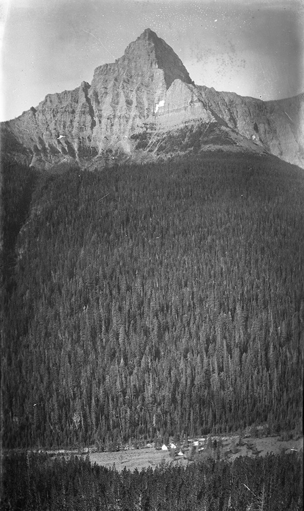
- Item consists of a small photo album bound in maroon leather with "Photographs" stamped on the front. Written on the inside of the front cover is "Tressa Brewster Banff, Alta" in black ink - Lade "Tressa" Brewster (nee Bagley) was Jim Brewster's first wife and mother of Fern. Photographs pertain to…
- Date Range
- [ca. 1900-1915]
- Reference Code
- V90 / IV / PD - 1
- Description Level
- 6 / Item
- GMD
- Photograph
- Part Of
- Jim Brewster family fonds
- Description Level
- 6 / Item
- Fonds Number
- M439 / V90
- Series
- IV. Brewster family
- Sous-Fonds
- V90
- Accession Number
- 2021.26
- Reference Code
- V90 / IV / PD - 1
- GMD
- Photograph
- Date Range
- [ca. 1900-1915]
- Physical Description
- 1 album (50 photographs : b&w ; 14.8 x 12.3 cm)
- History / Biographical
- See fonds level description.
- Scope & Content
- Item consists of a small photo album bound in maroon leather with "Photographs" stamped on the front. Written on the inside of the front cover is "Tressa Brewster Banff, Alta" in black ink - Lade "Tressa" Brewster (nee Bagley) was Jim Brewster's first wife and mother of Fern. Photographs pertain to landscapes taken throughout Alberta, mostly in and around Banff National Park, mounted on pages with built-in windows - some are annotated.
- Name Access
- Brewster, Tressa (Lade)
- Subject Access
- Activities
- Animals
- Banff Jasper Highway
- Buildings
- Buildings and facilities
- Deer
- Elk
- Environment and Nature
- Family and personal life
- Glaciers
- Landscapes
- Mount Assiniboine
- Mountains
- Photography
- Rivers
- Scenery
- Temple Mountain
- Wildlife
- Geographic Access
- Banff
- Lake Louise
- Bow Lake
- Assiniboine
- Banff National Park
- Alberta
- Canada
- Language
- English
- Conservation
- Leather of cover worn along edges, many photographs severely faded, some warped, spine coming loose at the binding towards the back.
- Biographical Source Notes
- https://www.findagrave.com/memorial/50087841/tressa-brewster
- Title Source
- Title based on item
- Processing Status
- Processed
This material is presented as originally created; it may contain outdated cultural descriptions and
potentially offensive content.
Read more.
Byron Harmon on mountain
https://archives.whyte.org/en/permalink/descriptions30202
- Part Of
- Byron Harmon fonds
- Date Range
- [between 1903 and 1942]
- Reference Code
- V263 / NA - 4162
- Description Level
- 6 / Item
- GMD
- Photograph
- Negative
1 image
- Part Of
- Byron Harmon fonds
- Description Level
- 6 / Item
- Fonds Number
- V263
- Series
- I. Scenic / commercial series
- Sub-Series
- A.1.a. Negatives, Main series : 13 x 18 cm and smaller
- Reference Code
- V263 / NA - 4162
- GMD
- Photograph
- Negative
- Date Range
- [between 1903 and 1942]
- Physical Description
- 1 photograph : negative, 13 x 18 cm or smaller
- Subject Access
- Environment and Nature
- Family and personal life
- Geographic Access
- Canada
- Creator
- Byron Harmon (Banff, Alberta)
Images

This material is presented as originally created; it may contain outdated cultural descriptions and
potentially offensive content.
Read more.
Byron Harmon on mountain
https://archives.whyte.org/en/permalink/descriptions37076
- Part Of
- Byron Harmon fonds
- Date Range
- [between 1903 and 1942]
- Reference Code
- V263 / NA - 4163
- Description Level
- 6 / Item
- GMD
- Photograph
- Negative
1 image
- Part Of
- Byron Harmon fonds
- Description Level
- 6 / Item
- Fonds Number
- V263
- Series
- I. Scenic / commercial series
- Sub-Series
- A.1.a. Negatives, Main series : 13 x 18 cm and smaller
- Reference Code
- V263 / NA - 4163
- GMD
- Photograph
- Negative
- Date Range
- [between 1903 and 1942]
- Physical Description
- 1 photograph : negative, 13 x 18 cm or smaller
- Subject Access
- Environment and Nature
- Family and personal life
- Geographic Access
- Canada
- Creator
- Byron Harmon (Banff, Alberta)
Images

This material is presented as originally created; it may contain outdated cultural descriptions and
potentially offensive content.
Read more.
Canadian Rockies negatives
https://archives.whyte.org/en/permalink/descriptions55738
- Part Of
- Jim Brewster family fonds
- Scope & Content
- File consists of 128 black and white photographic negatives of unidentified people, mountain landscapes, wildlife, and scenic views from throughout Banff National Park and surrounding areas.
- Date Range
- [ca. 1900-1915]
- Reference Code
- V90 / IV / NA - 01 to NA - 128
- Description Level
- 5 / File
- GMD
- Photograph
- Part Of
- Jim Brewster family fonds
- Description Level
- 5 / File
- Fonds Number
- M439 / V90
- Series
- IV. Brewster family
- Sous-Fonds
- V90
- Accession Number
- 2021.26
- Reference Code
- V90 / IV / NA - 01 to NA - 128
- GMD
- Photograph
- Date Range
- [ca. 1900-1915]
- Physical Description
- 128 photographs : b&w nitrate negatives ; 11.8 x 8.4 cm
- History / Biographical
- See fonds level description.
- Scope & Content
- File consists of 128 black and white photographic negatives of unidentified people, mountain landscapes, wildlife, and scenic views from throughout Banff National Park and surrounding areas.
- Notes
- Negatives were removed from their original housing in a negatives album (V90 / PD - 2) prior to processing
- Subject Access
- Activities
- Animals
- Banff Jasper Highway
- Buildings
- Buildings and facilities
- Deer
- Elk
- Environment and Nature
- Family and personal life
- Glaciers
- Landscapes
- Mount Assiniboine
- Mountains
- Photography
- Rivers
- Scenery
- Temple Mountain
- Wildlife
- Geographic Access
- Banff
- Lake Louise
- Banff National Park
- Assiniboine
- Alberta
- British Columbia
- Canada
- Language
- English
- Conservation
- Many negatives warped - NA - 13 is folded in half
- Related Material
- V90 / PD - 2
- Title Source
- Title based on item
- Processing Status
- Processed
This material is presented as originally created; it may contain outdated cultural descriptions and
potentially offensive content.
Read more.
Cartographic Materials
https://archives.whyte.org/en/permalink/descriptions23065
- Part Of
- Hans Gmoser fonds
- Scope & Content
- Cartographic materials in these four oversized files consist of the following:
- Date Range
- 1914-1973
- Reference Code
- M224 / O.S. Cartographic
- Description Level
- 5 / File
- Part Of
- Hans Gmoser fonds
- Description Level
- 5 / File
- Series
- IV.C. Textual records: Cartographic records
- Accession Number
- 7361, 7877, 8111
- Reference Code
- M224 / O.S. Cartographic
- Date Range
- 1914-1973
- Physical Description
- 48 cartographic records.
- Scope & Content
- Cartographic materials in these four oversized files consist of the following:
- Subject Access
- Discovery and Exploration
- Environment and Nature
- Family and personal life
- Sports and Recreation
- Title Source
- Title based on contents.
- Content Details
- Folder 1 Map on heavy paper, wrapped in plastic. “A Reconnaissance Topographic Map Suveyed and edited by Bradford Washburn” printed in Bern, Switzerland. Centred on Mt. McKinley.- From 7361. Palliser- Kananaskis Area British Columbia and Alberta- Publication No. 1962- Reprinted by the Surveys and Mapping Branch, Department of Mines and Technical Surveys, Ottawa. Mistaya British Columbia and Alberta- Compiled, drawn and printed at the office of the Surveyor General, Ottawa, 1931. Reprinted with corrections at the Surveys and Mapping Branch, Ottawa, 1950. National Topographic Series. Yoho British Columbia and Alberta- Compiled, drawn and printed at the office of the Surveyor General, Ottawa, 1932. Reprinted with corrections at the Surveys and Mapping Branch, Ottawa, 1952. National Topographic Series. Price 25 cents. Invermere British Columbia Kootenay Land District- National Topographic System- First Status Edition compiled and produced by the Geographic Division, Surveys, and Mapping Branch, Dept. of Lands, Forests and Water Resources, Victoria, BC 1964-65- annotated Beaton British Columbia Kootenay Land District- National Topographic System- First Status Edition compiled and produced by the Geographic Division, Surveys, and Mapping Branch, Dept. of Lands, Forests and Water Resources, Victoria, BC 1964-66- annotated Lardeau British Columbia Kootenay Land District- National Topographic System- First Status Edition compiled and produced by the Geographic Division, Surveys, and Mapping Branch, Dept. of Lands, Forests and Water Resources, Victoria, BC 1963- annotated Mount McKinley Alaska, Published by the Museum of Science, Boston, Mass, USA and the Swiss Foundation for Alpine Research, Zurich. 1960. Centennial Range Yukon Territory- M.C.R. 7 Edition 1- Produced and printed 1967 by the Surveys and Mapping Branch, Department of Energy, Mines and Resources- maps printed in 1961-62- annotated British Columbia Land Recording Dists.- Land Commissioner’s Offices- Department of Lands and Forests- first published 1957- Updated Nov. 1, 1960. Master Site Plan Bugaboo Creek Lodge Project number 6844- June 18, 1973- Cohos Delesalle & Evamy. Folder 2 Boundary Between Alberta and BC- Athabasca Pass- Sheet No. 27A – annotated- centered on Jasper Park Boundary Between Alberta and BC-All below Wheeler Maps (by hand) used for the Great Divide as per Chic-no topographical maps used for both Hans and similar maps were used by Chic bottom rip taped- Sheet No. 20- Drawn and printed by the Topographical Survey of Canada, Ottawa - centered on Clearwater forest and Lyell Icefield at bottom right Boundary Between Alberta and BC- Sheet No. 15- Drawn and printed at the Surveyor General’s Office, Ottawa, Canada- centered on Rocky Mountains Park Boundary Between Alberta and BC - Sheet No. 19- Drawn and printed at the Surveyor General’s Office, Ottawa, Canada- centered on centered on Clearwater Forest with Mt. Alan Campbell at bottom Boundary Between Alberta and BC- Sheet No. 25- annotated- Drawn and printed by the Topographical Survey of Canada, Ottawa - centered on Jasper Park with Chisel Peak at bottom Boundary Between Alberta and BC- Sheet No. 19- dirt and annotated- revised 1925- drawn and printed by the Topographical Survey of Canada, Ottawa- centered on Clearwater and Push Pass W. Boundary Between Alberta and BC- annotated- Sheet 16- revised 1925- drawn and printed by the Topographical Survey of Canada, Ottawa- centered on Yoho Park and Rocky Mountains Park Steele Glacier- Topographical Survey 1967 Arial Photography 1951 Mount St. Elias Canada- United State of America- Produced and Printed by the Surveys and Mapping Branch, Department of Mines and Technical Surveys 1962 from air photographs taken in 1951 and 1956- annotated Woolsey Glacier- Revelstoke National Park British Columbia – Printed by the Surveys and Mapping Branch Department of Energy, Mines and Resources- 1967 Windermere Kootenay District- Map 165A Issued 1918- Reprinted by the Surveys and Mapping Branch, Department of Mines and Technical Surveys, Ottawa. Folder 3 Boundary Between Alberta and BC- Sheet No. 20- heavily annotated- revised 1925- drawn and printed by the Topographical Survey of Canada, Ottawa- centered on Clearwater Forest, Saskatchewan Glacier at top left Boundary Between Alberta and BC- Sheet No. 18- heavily ripped- annotated - notes on back- revised 1925- drawn and printed by the Topographical Survey of Canada, Ottawa- centered on Clearwater Forest, Mt Mummery at bottom Boundary Between Alberta and BC- Sheet No. 17 (in pencil “A and B”)- annotated - heavily ripped- drawn and printed at the Surveyor Generals’ Office- centered on Clearwater Forest and Yoho Park Boundary Between Alberta and BC- Sheet No. 26- annotated- revised 1925- drawn and printed by the Topographical Survey of Canada, Ottawa- centered on Jasper Park and Icefields Boundary Between Alberta and BC- Sheet No. 17- revised 1925- drawn and printed by the Topographical Survey of Canada, Ottawa- centered on Clearwater Forest and Yoho Park Boundary Between Alberta and BC- Sheet No. 28- stained- centered on Jasper Park Boundary Between Alberta and BC- Sheet No. 24- annotated- revised edition, 1925- drawn and printed by the Topographical Survey of Canada, Ottawa- centered on Jasper Park Boundary Between Alberta and BC- Sheet No. 16- annotated- revised 1925- drawn and printed by the Topographical Survey of Canada, Ottawa- centered on Yoho and Rocky Mountains Park Interprovincial Boundary Commission Boundary Between Alberta and British Columbia. Revised edition 1925 drawn and printed by the Topographical Survey of Canada, Ottawa. Sheet No. 27. Following maps are from accession 7877. Interprovincial Boundary Commission Boundary Between Alberta and British Columbia. Surveyed 1920. Drawn and printed by the Topographical Survey of Canada, Ottawa. Sheet No. 26. Interprovincial Boundary Commission Boundary Between Alberta and British Columbia. Surveyed 1920, 1921. Drawn and printed by the Topographical Survey of Canada, Ottawa. Sheet No. 25. Interprovincial Boundary Commission Boundary Between Alberta and British Columbia. Surveyed 1919, 1921. Drawn and printed by the Topographical Survey of Canada, Ottawa. Sheet No. 24. Interprovincial Boundary Commission Boundary Between Alberta and British Columbia. Revised edition 1925 drawn and printed by the Topographical Survey of Canada, Ottawa. Sheet No. 21. Interprovincial Boundary Commission Boundary Between Alberta and British Columbia. Revised edition 1925 drawn and printed by the Topographical Survey of Canada, Ottawa. Sheet No. 18. Interprovincial Boundary Commission Boundary Between Alberta and British Columbia. Surveyed 1913. Drawn and printed by the Topographical Survey of Canada, Ottawa. Sheet No. 13 A. Interprovincial Boundary Commission Boundary Between Alberta and British Columbia. Surveyed 1916. Drawn and printed by the Topographical Survey of Canada, Ottawa. Sheet No. 12 A. Interprovincial Boundary Commission Boundary Between Alberta and British Columbia. Surveyed 1916. Drawn and printed by the Topographical Survey of Canada, Ottawa. Sheet No. 11. Interprovincial Boundary Commission Boundary Between Alberta and British Columbia. Surveyed 1916. Drawn and printed by the Topographical Survey of Canada, Ottawa. Sheet No. 10. Interprovincial Boundary Commission Boundary Between Alberta and British Columbia. Surveyed 1916. Drawn and printed by the Topographical Survey of Canada, Ottawa. Sheet No. 9. Interprovincial Boundary Commission Boundary Between Alberta and British Columbia. Surveyed 1916. Drawn and printed by the Topographical Survey of Canada, Ottawa. Sheet No. 8. Interprovincial Boundary Commission Boundary Between Alberta and British Columbia. Surveyed 1916. Drawn and printed by the Topographical Survey of Canada, Ottawa. Sheet No. 6. Interprovincial Boundary Commission Boundary Between Alberta and British Columbia. Surveyed 1915. Drawn and printed by the Topographical Survey of Canada, Ottawa. Sheet No. 5. Interprovincial Boundary Commission Boundary Between Alberta and British Columbia. Surveyed 1914. Drawn and printed by the Topographical Survey of Canada, Ottawa. Sheet No. 4. Interprovincial Boundary Commission Boundary Between Alberta and British Columbia. Surveyed 1922. Drawn and printed by the Topographical Survey of Canada, Ottawa. Sheet No. 31. Interprovincial Boundary Commission Boundary Between Alberta and British Columbia. Surveyed 1922, 1924. Drawn and printed by the Topographical Survey of Canada, Ottawa. Sheet No. 30. Interprovincial Boundary Commission Boundary Between Alberta and British Columbia. Surveyed 1917. Drawn and printed by the Topographical Survey of Canada, Ottawa. Sheet No. 29.
- Processing Status
- Processed
This material is presented as originally created; it may contain outdated cultural descriptions and
potentially offensive content.
Read more.
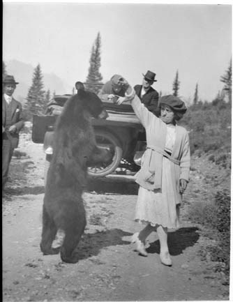
E-24. Woman feeding bear, Elsie Brooks
https://archives.whyte.org/en/permalink/descriptions29210
- Part Of
- Byron Harmon fonds
- Date Range
- [between 1903 and 1942]
- Reference Code
- V263 / NA - 2893
- Description Level
- 6 / Item
- GMD
- Photograph
- Negative
1 image
- Part Of
- Byron Harmon fonds
- Description Level
- 6 / Item
- Fonds Number
- V263
- Series
- I. Scenic / commercial series
- Sub-Series
- A.1.a. Negatives, Main series : 13 x 18 cm and smaller
- Reference Code
- V263 / NA - 2893
- GMD
- Photograph
- Negative
- Date Range
- [between 1903 and 1942]
- Physical Description
- 1 photograph : negative, copy, 13 x 18 cm or smaller
- Subject Access
- Environment and Nature
- Family and personal life
- Geographic Access
- Alberta
- Conservation
- Reprocessed / archival quality gold-toned, 1973
- Creator
- Byron Harmon (Banff, Alberta)
Images
This material is presented as originally created; it may contain outdated cultural descriptions and
potentially offensive content.
Read more.
Joshua Twin (Nûbabin) and daughters
https://archives.whyte.org/en/permalink/descriptions39514
- Part Of
- Moore family fonds
- Scope & Content
- Item consists of hand-couloured transparency of Joshua Twin (Nûbabin) with his daughters.
- Date Range
- 1899 - 1927
- Reference Code
- V439 / PS - 340
- Description Level
- 6 / Item
- GMD
- Photograph
- Lantern slide
- Transparency
1 image
- Part Of
- Moore family fonds
- Description Level
- 6 / Item
- Fonds Number
- V439
- Series
- I. Philip Moore series
- Sous-Fonds
- V439
- Sub-Series
- B. Professional papers and photographs 2. Research, writing and lecturing d. Photographs i. Lantern slides (transparencies)
- Reference Code
- V439 / PS - 340
- Date Range
- 1899 - 1927
- Physical Description
- 1 transparency : lantern slide
- Scope & Content
- Item consists of hand-couloured transparency of Joshua Twin (Nûbabin) with his daughters.
- Name Access
- Twin, William
- Subject Access
- Stoney Nakoda
- Indigenous Peoples
- Discovery and exploration
- Environment and Nature
- Family and personal life
- First Nations
- Geographic Access
- Alberta
- Creator
- [Byron Harmon]
- Title Source
- Title is based on contents of item
- Processing Status
- Processed
Images

This material is presented as originally created; it may contain outdated cultural descriptions and
potentially offensive content.
Read more.
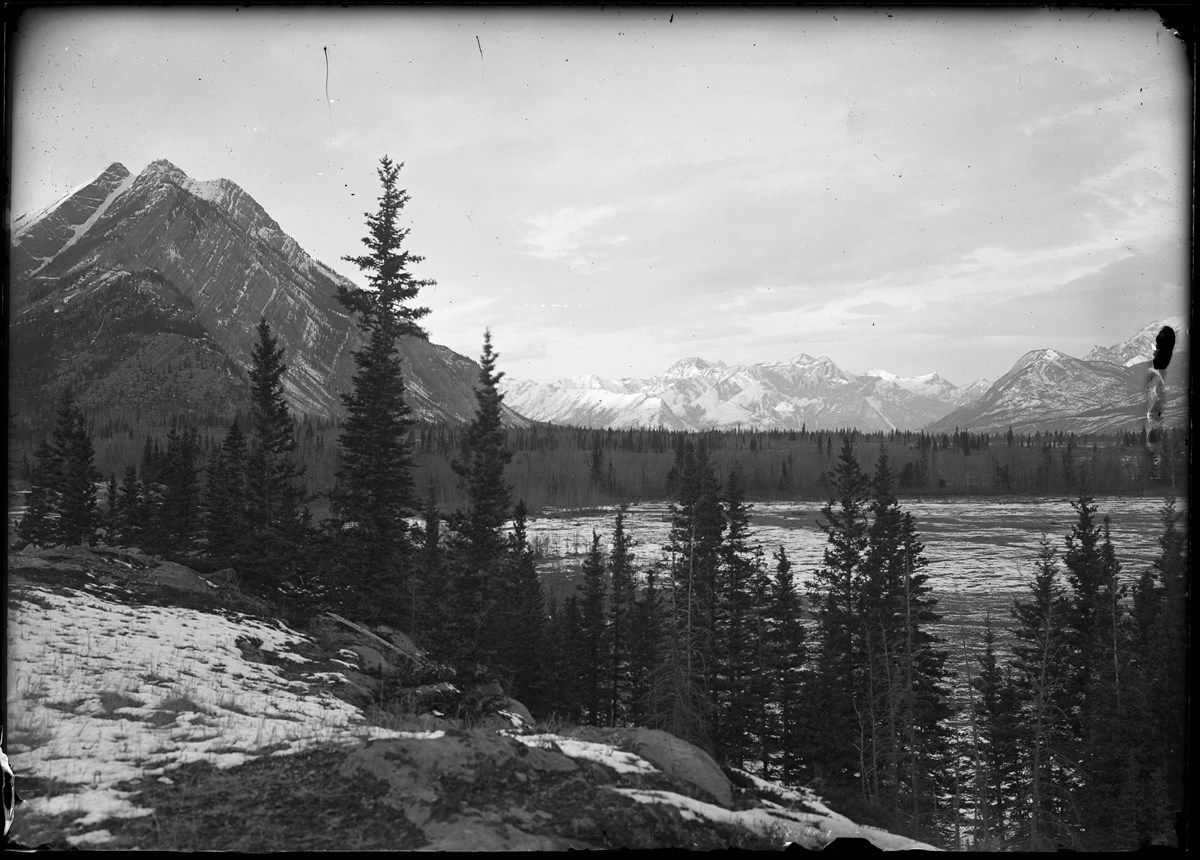
Kootenay Plains and Mt. Siffleur
https://archives.whyte.org/en/permalink/descriptions37887
- Part Of
- Elliott Barnes fonds
- Date Range
- [ca.1905-ca.1914]
- Reference Code
- V48 / NG - 7
- Description Level
- 6 / Item
- GMD
- Photograph
1 image
- Part Of
- Elliott Barnes fonds
- Description Level
- 6 / Item
- Series
- I. Negative series
- Reference Code
- V48 / NG - 7
- GMD
- Photograph
- Date Range
- [ca.1905-ca.1914]
- Physical Description
- 1 photograph : negative, glass, 13 x 18 cm or smaller
- Geographic Access
- Alberta
- Creator
- Elliott Barnes
Images
This material is presented as originally created; it may contain outdated cultural descriptions and
potentially offensive content.
Read more.
Kootenay Plains and unknown peak
https://archives.whyte.org/en/permalink/descriptions37888
- Part Of
- Elliott Barnes fonds
- Date Range
- [ca.1905-ca.1914]
- Reference Code
- V48 / NG - 8
- Description Level
- 6 / Item
- GMD
- Photograph
1 image
- Part Of
- Elliott Barnes fonds
- Description Level
- 6 / Item
- Series
- I. Negative series
- Reference Code
- V48 / NG - 8
- GMD
- Photograph
- Date Range
- [ca.1905-ca.1914]
- Physical Description
- 1 photograph : negative, glass, 13 x 18 cm or smaller
- Geographic Access
- Alberta
- Creator
- Elliott Barnes
Images

This material is presented as originally created; it may contain outdated cultural descriptions and
potentially offensive content.
Read more.
- Part Of
- Bert Riggall fonds
- Scope & Content
- File consists of 425 b&w negatives. The negatives pertain to Riggall packtrains and camps, bighorn sheep, hunting, hunting trophies, various landscapes, men posing with hunting trophies, portraits of the Cox family, portraits of Riggall cousins at Brooks, flowers (calipso orchid), Parkview school p…
- Date Range
- [ca.1904 to ca.1959]
- Reference Code
- V26 / IX / B / NA (B1 to B45)
- Description Level
- 5 / File
- GMD
- Photograph
- Negative
5 images
- Part Of
- Bert Riggall fonds
- Description Level
- 5 / File
- Fonds Number
- M376 / V26
- Series
- IX. Riggall Negatives Scanned and Described
- Sous-Fonds
- V26
- Accession Number
- 7102
- Reference Code
- V26 / IX / B / NA (B1 to B45)
- GMD
- Photograph
- Negative
- Date Range
- [ca.1904 to ca.1959]
- Physical Description
- 425 photographs : b&w negatives
- Scope & Content
- File consists of 425 b&w negatives. The negatives pertain to Riggall packtrains and camps, bighorn sheep, hunting, hunting trophies, various landscapes, men posing with hunting trophies, portraits of the Cox family, portraits of Riggall cousins at Brooks, flowers (calipso orchid), Parkview school picture, Hawk's nest, well drilling, clients fishing, and Riggall's cars.
- Subject Access
- Packing
- Pack trips
- Hunting
- Sports
- Recreation
- Portrait
- Family and personal life
- Animals
- Bighorn Sheep
- Environment and Nature
- Fishing
- Natural resources
- Geographic Access
- Canada
- Alberta
- Brooks
- Language
- N/A
- Category
- Environment
- Family and personal life
- Exploration, discovery and travel
- Sports, recreation and leisure
- Title Source
- Title based on contents of file
- Content Details
- Reference scans available: V26 / IX / B / PA (B1 to B45)
- Processing Status
- Processed
Images

This material is presented as originally created; it may contain outdated cultural descriptions and
potentially offensive content.
Read more.