Narrow Results By
[Gap 82 G/16 West - Alberta]
https://archives.whyte.org/en/permalink/catalogue23623
- Medium
- Library - Maps and blueprints (unannotated; published)
- Map
- Published Date
- 1944
- Publisher
- Dept. of Mines and Technical Surveys
- Call Number
- NTS
- 82G/16W
- Publisher
- Dept. of Mines and Technical Surveys
- Published Date
- 1944
- Physical Description
- Black and White
- Scale
- Scale: 1:50,000
- Relief: Contour interval 100'
- Subjects
- Gap 82 G/16 West - Alberta
- Notes
- National Topographical System
- Call Number
- NTS
- 82G/16W
- Collection
- Archives Library
This material is presented as originally created; it may contain outdated cultural descriptions and
potentially offensive content.
Read more.
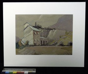
The New Plant at the Gap - Banff Road
https://archives.whyte.org/en/permalink/artifactgyh.05.04
- Date
- 1936
- Medium
- watercolour on paper
- Catalogue Number
- GyH.05.04
- Description
- An industrial plant is situated next to the side of the mountain. This may be a gravel plant or perhaps a cement plant somewhere near Exshaw.
1 image
- Title
- The New Plant at the Gap - Banff Road
- Date
- 1936
- Medium
- watercolour on paper
- Description
- An industrial plant is situated next to the side of the mountain. This may be a gravel plant or perhaps a cement plant somewhere near Exshaw.
- Credit
- Gift of Henry George Glyde, Victoria, 1997
- Catalogue Number
- GyH.05.04
Images
This material is presented as originally created; it may contain outdated cultural descriptions and
potentially offensive content.
Read more.
Topographical sheet
https://archives.whyte.org/en/permalink/catalogue24660
- Medium
- Library - Maps and blueprints (unannotated; published)
- Map
- Published Date
- 1890
- Publisher
- Dept. of the Interio
- Call Number
- C3-8.20
- Publisher
- Dept. of the Interio
- Published Date
- 1890
- Scale
- Scale: 1:40,000
- Relief: Contour interval 100 ft.
- Subjects
- Gap
- Notes
- Photostatic copy from Public Archives
- Accession Number
- 675
- Call Number
- C3-8.20
- Collection
- Archives Library
This material is presented as originally created; it may contain outdated cultural descriptions and
potentially offensive content.
Read more.
- Artist
- Wilfred Lambert
- Date
- 1985
- Medium
- print on paper
- Catalogue Number
- LaW.04.16
- Description
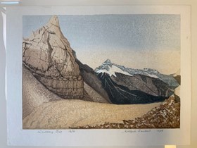
- A block print of a beige plateau with a beige mountain prominently featured at left. In distance are grey snowcapped mountains with tree covered lower slopes. Sky is a gradient from blue to yellow. “Wiwaxy Gap 13/33” is written at bottom left in pencil and “Wilfred Lambert 1985” is written at botto…
1 image
- Artist
- Wilfred Lambert
- Title
- Wiwaxy Gap
- Date
- 1985
- Medium
- print on paper
- Dimensions
- 32.0 x 42.0 cm
- Description
- A block print of a beige plateau with a beige mountain prominently featured at left. In distance are grey snowcapped mountains with tree covered lower slopes. Sky is a gradient from blue to yellow. “Wiwaxy Gap 13/33” is written at bottom left in pencil and “Wilfred Lambert 1985” is written at bottom right.
- Credit
- Gift of Tim Wake, Whistler, 1990
- Catalogue Number
- LaW.04.16
Images
This material is presented as originally created; it may contain outdated cultural descriptions and
potentially offensive content.
Read more.


