Narrow Results By
- Part Of
- Malcolm Geddes fonds
- Scope & Content
- File consists of two lantern slide photographs of western and eastern Canadian national parks maps.
- Date Range
- [ca.1925]
- Reference Code
- V756 / III / A / PS - 231 and 232
- Description Level
- 5 / File
- GMD
- Photograph
- Lantern slide
- Map
- Part Of
- Malcolm Geddes fonds
- Description Level
- 5 / File
- Fonds Number
- M39
- V756
- Series
- V756 / III : Personal and family records
- Sous-Fonds
- V756
- Sub-Series
- V756 / III / A : Travel and mountain expeditions
- Accession Number
- 6504
- Reference Code
- V756 / III / A / PS - 231 and 232
- Date Range
- [ca.1925]
- Physical Description
- 2 photographs : lantern slides
- Scope & Content
- File consists of two lantern slide photographs of western and eastern Canadian national parks maps.
- Material Details
- Lantern slides are hand-coloured
- Subject Access
- Map
- Geography
- National parks and reserves
- Travel
- Geographic Access
- Canada
- Access Restrictions
- Fragile - restrictions may apply
- Language
- N/A
- Category
- Exploration, discovery and travel
- Title Source
- Title based on contents of file
- Processing Status
- Processed
This material is presented as originally created; it may contain outdated cultural descriptions and
potentially offensive content.
Read more.
Canadian news publications
https://archives.whyte.org/en/permalink/descriptions54761
- Part Of
- Luxton family fonds
- Scope & Content
- File consists of 3 full copies of Canadian news publications including The Dominion Illustrated, Montreal Star, and The Montreal Herald, as well as one torn section from a 1937 edition of the Edmonton Bulletin newspaper. Content pertains to business development, agriculture, trade and local history…
- Date Range
- 1890
- 1901
- 1927
- 1937
- Reference Code
- LUX / II / F1 / 41 to 44
- Description Level
- 5 / File
- GMD
- Textual record
- Published record
- Part Of
- Luxton family fonds
- Description Level
- 5 / File
- Fonds Number
- LUX
- Series
- LUX / II / F : Collected material
- Sous-Fonds
- LUX / II : Eleanor Luxton sous-fonds
- Sub-Series
- LUX / II / F1 : Textual
- Accession Number
- LUX
- Reference Code
- LUX / II / F1 / 41 to 44
- Date Range
- 1890
- 1901
- 1927
- 1937
- Physical Description
- 1.5 cm of textual records (4 volumes ; 28.5 x 41 cm or smaller)
- Scope & Content
- File consists of 3 full copies of Canadian news publications including The Dominion Illustrated, Montreal Star, and The Montreal Herald, as well as one torn section from a 1937 edition of the Edmonton Bulletin newspaper. Content pertains to business development, agriculture, trade and local history in Calgary; a Royal Visit by the Duke and Duchess of Cornwall and York to Canada in 1901; Canadian trade, industry and tourism; and political tension between Russia and Japan prior to World War II.
- Subject Access
- Advertising
- Agriculture
- Businesses
- Commerce
- Environment
- Finances
- Indigenous Peoples
- Land, settlement and immigration
- Manufacturing
- Military
- National parks and reserves
- Natural resources
- Politics
- Geography
- History
- Industry
- Government
- Royal Visit
- Royal tours
- Royalty
- Sports and recreation
- Tourism
- Travel
- War
- Geographic Access
- Canada
- Alberta
- Calgary
- Edmonton
- Quebec
- Montreal
- Russia
- Japan
- Language
- English
- Conservation
- Edmonton Bulletin newspaper has been placed in mylar
- All items stored flat in oversize box to prevent further creasing and damage
- Category
- Commerce and industry
- Exploration, discovery and travel
- Land, settlement and immigration
- Politics
- Title Source
- Title based on contents of file
- Content Details
- Items are arranged chronologically in file box: LUX / II / F1 / 41 : "The Dominion Illustrated" [1890] LUX / II / F1 / 42 : "The Royal Visit to Canada 1901", Montreal Star LUX / II / F1 / 43 : "The National Number of the Montreal Herald" [1927] LUX / II / F1 / 44 : "Edmonton Bulletin" [1937]
- Processing Status
- Processed
This material is presented as originally created; it may contain outdated cultural descriptions and
potentially offensive content.
Read more.
Maps of Banff and Western Canada
https://archives.whyte.org/en/permalink/descriptions54772
- Part Of
- Luxton family fonds
- Scope & Content
- File consists of 9 printed maps, b&w and col. [including zoning and topographical maps] depicting the Town of Banff and Banff National Park, the Rocky Mountains Forest Reserve, the Moose Mountain region, Medicine Hat, and the province of Alberta. File includes Trail Riders' Map of the Canadian Rock…
- Date Range
- 1912
- 1914
- 1924
- 1926
- 1932
- 1957
- [1970-1980]
- Reference Code
- LUX / II / C5 / 25
- Description Level
- 5 / File
- GMD
- Textual record
- Published record
- Map
- Part Of
- Luxton family fonds
- Description Level
- 5 / File
- Fonds Number
- LUX
- Series
- LUX / II / C : Personal
- Sous-Fonds
- LUX / II : Eleanor Luxton sous-fonds
- Sub-Series
- LUX / II / C5 : Other
- Accession Number
- LUX
- Reference Code
- LUX / II / C5 / 25
- Date Range
- 1912
- 1914
- 1924
- 1926
- 1932
- 1957
- [1970-1980]
- Physical Description
- 9 maps : b&w and col. ; 168 x 71 cm or smaller
- Scope & Content
- File consists of 9 printed maps, b&w and col. [including zoning and topographical maps] depicting the Town of Banff and Banff National Park, the Rocky Mountains Forest Reserve, the Moose Mountain region, Medicine Hat, and the province of Alberta. File includes Trail Riders' Map of the Canadian Rockies which has smaller maps of Waterton Lakes, Glacier, Revelstoke, and other national parks printed on the back. Map of Medicine Hat includes annotated storage envelope with dimensions written on the front.
- Subject Access
- Cartography
- Geography
- Land use
- Government
- Travel
- National parks and reserves
- Geographic Access
- Canada
- Alberta
- Banff
- Banff National Park
- Medicine Hat
- Rocky Mountains
- Glacier National Park
- Revelstoke
- Waterton Lakes National Park
- Reproduction Restrictions
- Restrictions may apply
- Language
- English
- Title Source
- Title based on contents of file
- Processing Status
- Processed
This material is presented as originally created; it may contain outdated cultural descriptions and
potentially offensive content.
Read more.
Map, Indian Tribes of North America
https://archives.whyte.org/en/permalink/descriptions54800
- Part Of
- Luxton family fonds
- Scope & Content
- File consists of one b&w printed paper copy of a map titled "Indian Tribes of North America" [n.d., creator unknown].
- Date Range
- [1950-1970]
- Reference Code
- LUX / II / F1 / 56
- Description Level
- 5 / File
- GMD
- Map
- Textual record
- Published record
- Part Of
- Luxton family fonds
- Description Level
- 5 / File
- Fonds Number
- LUX
- Series
- LUX / II / F : Collected material
- Sous-Fonds
- LUX / II : Eleanor Luxton sous-fonds
- Sub-Series
- LUX / II / F1 : Textual
- Accession Number
- LUX
- Reference Code
- LUX / II / F1 / 56
- Date Range
- [1950-1970]
- Physical Description
- 0.1 cm of textual records (map : b&w ; 48 x 53.5 cm)
- Scope & Content
- File consists of one b&w printed paper copy of a map titled "Indian Tribes of North America" [n.d., creator unknown].
- Notes
- Date range is estimate provided by Processing Archivist
- Subject Access
- Geography
- Indigenous Peoples
- Land, settlement and immigration
- Geographic Access
- Canada
- United States of America
- Reproduction Restrictions
- Restrictions may apply
- Language
- English
- Title Source
- Title taken from item in file
- Processing Status
- Processed
This material is presented as originally created; it may contain outdated cultural descriptions and
potentially offensive content.
Read more.
Published regional and trail maps
https://archives.whyte.org/en/permalink/descriptions54847
- Scope & Content
- File consists of maps depicting the Banff townsite and nearby travel routes. Includes a trail map for Banff, Yoho and Kootenay National Parks; a road map for Banff and nearby areas [1965]; a numbered townsite map of Banff marking local hotels and attractions; and a photocopied map of a trail route …
- Date Range
- [1950-1970]
- 1965
- Reference Code
- M545 / III / 29
- Description Level
- 5 / File
- GMD
- Textual record
- Published record
- Map
- Description Level
- 5 / File
- Fonds Number
- M545 / V635
- Series
- M545 / III : Published records
- Sous-Fonds
- M545
- Accession Number
- 5939
- Reference Code
- M545 / III / 29
- Date Range
- [1950-1970]
- 1965
- Physical Description
- 0.5 cm of textual records (4 maps ; 35.5 x 21.5 cm or smaller)
- Scope & Content
- File consists of maps depicting the Banff townsite and nearby travel routes. Includes a trail map for Banff, Yoho and Kootenay National Parks; a road map for Banff and nearby areas [1965]; a numbered townsite map of Banff marking local hotels and attractions; and a photocopied map of a trail route used by the Trail Riders of the Canadian Rockies [n.d.]
- Notes
- Banff townsite map has annotation marking the location of the Trail Ride Office on Caribou St.
- Subject Access
- Travel
- Trails
- Map
- Land, settlement and immigration
- Geography
- Geographic Access
- Canada
- Alberta
- Banff
- Banff National Park
- Yoho National Park
- Kootenay National Park
- Reproduction Restrictions
- Restrictions may apply
- Language
- English
- Title Source
- Title based on contents of file
- Processing Status
- Processed
This material is presented as originally created; it may contain outdated cultural descriptions and
potentially offensive content.
Read more.
Banff National Park and Lake Louise maps
https://archives.whyte.org/en/permalink/descriptions54945
- Scope & Content
- File consists of two folded maps and a small clipping [possibly top or bottom portion from a different map or one of maps in file]. One map is of Banff National Park and one is of Lake Louise [1959]. Banff National Park map has black pencil tracings over trail section near the bottom of the map and…
- Date Range
- 1959
- [1960-1970]
- Reference Code
- M545 / V / 53
- Description Level
- 5 / File
- GMD
- Textual record
- Published record
- Map
- Description Level
- 5 / File
- Fonds Number
- M545 / V635
- Series
- M545 / V : Administrative records
- Sous-Fonds
- M545
- Accession Number
- 8235
- Reference Code
- M545 / V / 53
- Date Range
- 1959
- [1960-1970]
- Physical Description
- 0.5 cm of textual records (2 maps ; 60.5 x 57.5 and 60 x 56.5 cm)
- Scope & Content
- File consists of two folded maps and a small clipping [possibly top or bottom portion from a different map or one of maps in file]. One map is of Banff National Park and one is of Lake Louise [1959]. Banff National Park map has black pencil tracings over trail section near the bottom of the map and annotation in bottom right corner which reads "Natural Bridge". Lake Louise map produced by the Government of Canada.
- Subject Access
- Banff National Park
- Environment
- Geography
- Map
- Lake Louise
- Travel
- Government
- National parks and reserves
- Trails
- Geographic Access
- Canada
- Alberta
- Banff National Park
- Lake Louise
- Language
- English
- Conservation
- Clipping stored in mylar due to significant staining and residue from tape
- Items kept folded [not placed in mylar] due to mass production of content and minimal/no annotations
- Title Source
- Title based on contents of file
- Processing Status
- Processed
This material is presented as originally created; it may contain outdated cultural descriptions and
potentially offensive content.
Read more.
Travel guides - United States, Italy
https://archives.whyte.org/en/permalink/descriptions55928
- Part Of
- Ben Gadd fonds
- Scope & Content
- File consists of travel guides collected by Ben Gadd pertaining to Olympic National Park and other destinations in the United States and Italy.
- Date Range
- [ca.1990-2010]
- Reference Code
- M590 / I / A / i / 14
- Description Level
- 5 / File
- GMD
- Published record
- Textual record
- Map
- Part Of
- Ben Gadd fonds
- Description Level
- 5 / File
- Fonds Number
- M590
- V810
- S61
- Series
- M590 / I : Personal records
- Sous-Fonds
- M590
- Sub-Series
- M590 / I / A : Travel guides and maps
- Accession Number
- 2021.20
- Reference Code
- M590 / I / A / i / 14
- Date Range
- [ca.1990-2010]
- Physical Description
- 2 cm of textual records
- Scope & Content
- File consists of travel guides collected by Ben Gadd pertaining to Olympic National Park and other destinations in the United States and Italy.
- Subject Access
- Geography
- Travel
- Tourism
- Tourist information
- National parks and reserves
- Geographic Access
- United States of America
- Washington
- Hawaii
- Italy
- Reproduction Restrictions
- Copyright restrictions may apply
- Language
- English
- Category
- Exploration, discovery and travel
- Title Source
- Title based on contents of file
- Processing Status
- Processed
This material is presented as originally created; it may contain outdated cultural descriptions and
potentially offensive content.
Read more.
Jasper Trails Project - printed trail maps
https://archives.whyte.org/en/permalink/descriptions56152
- Part Of
- Ben Gadd fonds
- Scope & Content
- File consists of printed drafts of trail maps depicting regions near Pyramid Bench, Maligne Canyon, Wabasso Lake and Miette River; and quotes from three printing companies in Alberta. Materials pertain to the updating of trail signage and interpretive information through the Jasper Trails Project.
- Date Range
- 1997-1998
- Reference Code
- M590 / III / D / 106
- Description Level
- 5 / File
- GMD
- Textual record
- Map
- Part Of
- Ben Gadd fonds
- Description Level
- 5 / File
- Fonds Number
- M590
- V810
- S61
- Series
- M590 / III : Published records
- Sous-Fonds
- M590
- Sub-Series
- M590 / III / D : Other contracts and projects
- Accession Number
- 2021.20
- Reference Code
- M590 / III / D / 106
- GMD
- Textual record
- Map
- Date Range
- 1997-1998
- Physical Description
- 0.2 cm of textual records
- Scope & Content
- File consists of printed drafts of trail maps depicting regions near Pyramid Bench, Maligne Canyon, Wabasso Lake and Miette River; and quotes from three printing companies in Alberta. Materials pertain to the updating of trail signage and interpretive information through the Jasper Trails Project.
- Subject Access
- Organization
- Trails
- Research
- Map
- Environment
- Hiking
- Recreation
- Geography
- Parks Canada
- Government
- Geographic Access
- Canada
- Alberta
- Jasper
- Jasper National Park
- Edmonton
- Reproduction Restrictions
- Restrictions may apply
- Language
- English
- Title Source
- Title based on contents of file
- Processing Status
- Processed
This material is presented as originally created; it may contain outdated cultural descriptions and
potentially offensive content.
Read more.
Jasper Trails Project - sign location maps
https://archives.whyte.org/en/permalink/descriptions56154
- Part Of
- Ben Gadd fonds
- Scope & Content
- File consists of maps showing the locations of interpretive signs which were updated and installed as part of the Jasper Trails Project. File includes film positive copies of maps, and related notes and correspondence.
- Date Range
- 1995
- 1997
- Reference Code
- M590 / III / D / 107
- Description Level
- 5 / File
- GMD
- Textual record
- Map
- Part Of
- Ben Gadd fonds
- Description Level
- 5 / File
- Fonds Number
- M590
- V810
- S61
- Series
- M590 / III : Published records
- Sous-Fonds
- M590
- Sub-Series
- M590 / III / D : Other contracts and projects
- Accession Number
- 2021.20
- Reference Code
- M590 / III / D / 107
- GMD
- Textual record
- Map
- Date Range
- 1995
- 1997
- Physical Description
- 1 cm of textual records
- Scope & Content
- File consists of maps showing the locations of interpretive signs which were updated and installed as part of the Jasper Trails Project. File includes film positive copies of maps, and related notes and correspondence.
- Subject Access
- Organization
- Trails
- Research
- Map
- Environment
- Hiking
- Recreation
- Geography
- Parks Canada
- Government
- Geographic Access
- Canada
- Alberta
- Jasper
- Jasper National Park
- Reproduction Restrictions
- Restrictions may apply
- Language
- English
- Title Source
- Title based on contents of file
- Processing Status
- Processed
This material is presented as originally created; it may contain outdated cultural descriptions and
potentially offensive content.
Read more.
World Progress scrapbook
https://archives.whyte.org/en/permalink/descriptions22410
- Part Of
- Luxton family fonds
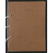
- Scope & Content
- Scrapbook is handmade from coloured construction paper. Scrapbook consists of newspaper clippings dated between 1939 and 1940 pertaining to global and Canadian agriculture, commerce, mining, politics and military statistics. Scrapbook is annotated with title on front cover: "World Progress Finances…
- Date Range
- 1939 - 1940
- Reference Code
- LUX / III / B4 - 26
- Description Level
- 5 / File
- GMD
- Textual record
- Scrapbook
- Newspaper clipping
1 image
1 Electronic Resource
- Part Of
- Luxton family fonds
- Description Level
- 5 / File
- Fonds Number
- LUX
- Series
- III.B.4. Georgina Luxton : Collected Material : Textual Records
- Sous-Fonds
- III. Luxton Family sous-fonds
- Accession Number
- LUX
- Reference Code
- LUX / III / B4 - 26
- Date Range
- 1939 - 1940
- Physical Description
- 2 cm of textual records
- Scope & Content
- Scrapbook is handmade from coloured construction paper. Scrapbook consists of newspaper clippings dated between 1939 and 1940 pertaining to global and Canadian agriculture, commerce, mining, politics and military statistics. Scrapbook is annotated with title on front cover: "World Progress Finances Agriculture Travel Protection". Scrapbook contains table of contents inside front cover [see "Content Details"].
- Subject Access
- Agriculture
- Commerce
- Copper and copper mines
- Environment
- Geography
- History
- Industry
- Labour
- Legal and Financial
- Military
- Mines and mineral resources
- Mining
- Natural resources
- Newspaper
- Politics
- War
- World War II
- Geographic Access
- Canada
- Ireland
- Germany
- England
- Russia
- France
- United States of America
- Panama
- Language
- English
- Conservation
- Three metal binder rings have been removed and replaced with unbleached string to protect paper contents of scrapbook
- Category
- Commerce and industry
- Environment
- Government
- Labour
- Military
- Natural resources
- Politics
- Science and technology
- Title Source
- Title based on contents of item
- Content Details
- [Table of Contents:] Organized Man Power: Ireland and the War Wheat: Britain and War Taxes Food and the War Wool, Cattle, Metal Markets; Bacteria in Milk Oil, Butter, Sugar: Rayon, Bluestone, Radium Chemical Production in the United States New Methods of Transportation The Soy Bean Irrigation Development of the Soviet Union The Chain Store Co-operatives: Frontier Opening Montreal as a Market Investments Africa Chile: Russia Germany and Synthetic Goods Bermuda: Gibraltar The Great Lakes Project: Rice: Farm Moisture London: The Panama and the Americas Great Britain: Banff: Canada Canada's Milk Production: Butter: Results of War on Sugar, etc. U.S. Alaska Highway: Canada Facts and the Flag Possible mines in Canada: U.S.A. and Latin America Deserts and Snow: The Caribbean Pacific Defences [sic] and the Panama Canal Trans Canada Air Lines: Oil and the War Canada and Japan area comparison: Transatlantic Airways European Politics and Men at the Head of Governments
- Processing Status
- Processed
Electronic Resources
Images

This material is presented as originally created; it may contain outdated cultural descriptions and
potentially offensive content.
Read more.