Narrow Results By
- Ben Gadd fonds 27
- Luxton family fonds 8
- Bruno Engler fonds 5
- Trail Riders of the Canadian Rockies fonds 5
- Canadian Inventory of Historic Building Survey fonds 3
- Dorothy Wardle fonds 3
- Kidney family fonds 2
- Maryalice Harvey Stewart fonds 2
- Arthur Oliver Wheeler fonds 1
- Banff Municipal Committee fonds 1
- Banff School District No. 102 fonds 1
- Banff Townsite Provisional Administration Board fonds 1
Maps of Banff and Western Canada
https://archives.whyte.org/en/permalink/descriptions54772
- Part Of
- Luxton family fonds
- Scope & Content
- File consists of 9 printed maps, b&w and col. [including zoning and topographical maps] depicting the Town of Banff and Banff National Park, the Rocky Mountains Forest Reserve, the Moose Mountain region, Medicine Hat, and the province of Alberta. File includes Trail Riders' Map of the Canadian Rock…
- Date Range
- 1912
- 1914
- 1924
- 1926
- 1932
- 1957
- [1970-1980]
- Reference Code
- LUX / II / C5 / 25
- Description Level
- 5 / File
- GMD
- Textual record
- Published record
- Map
- Part Of
- Luxton family fonds
- Description Level
- 5 / File
- Fonds Number
- LUX
- Series
- LUX / II / C : Personal
- Sous-Fonds
- LUX / II : Eleanor Luxton sous-fonds
- Sub-Series
- LUX / II / C5 : Other
- Accession Number
- LUX
- Reference Code
- LUX / II / C5 / 25
- Date Range
- 1912
- 1914
- 1924
- 1926
- 1932
- 1957
- [1970-1980]
- Physical Description
- 9 maps : b&w and col. ; 168 x 71 cm or smaller
- Scope & Content
- File consists of 9 printed maps, b&w and col. [including zoning and topographical maps] depicting the Town of Banff and Banff National Park, the Rocky Mountains Forest Reserve, the Moose Mountain region, Medicine Hat, and the province of Alberta. File includes Trail Riders' Map of the Canadian Rockies which has smaller maps of Waterton Lakes, Glacier, Revelstoke, and other national parks printed on the back. Map of Medicine Hat includes annotated storage envelope with dimensions written on the front.
- Subject Access
- Cartography
- Geography
- Land use
- Government
- Travel
- National parks and reserves
- Geographic Access
- Canada
- Alberta
- Banff
- Banff National Park
- Medicine Hat
- Rocky Mountains
- Glacier National Park
- Revelstoke
- Waterton Lakes National Park
- Reproduction Restrictions
- Restrictions may apply
- Language
- English
- Title Source
- Title based on contents of file
- Processing Status
- Processed
This material is presented as originally created; it may contain outdated cultural descriptions and
potentially offensive content.
Read more.
Four Mountain Parks Planning Program
https://archives.whyte.org/en/permalink/descriptions54919
- Scope & Content
- File consists of a planning scenario draft, response form and information sheet, draft of possible implications, meeting notes and comments, and correspondence between Parks Canada and the Trail Riders of the Canadian Rockies. Content pertains to the Four Mountain Parks Program implemented by Parks…
- Date Range
- 1984-1985
- Reference Code
- M545 / V / 24
- Description Level
- 5 / File
- GMD
- Textual record
- Government record
- Description Level
- 5 / File
- Fonds Number
- M545 / V635
- Series
- M545 / V : Administrative records
- Sous-Fonds
- M545
- Accession Number
- 5939
- Reference Code
- M545 / V / 24
- Date Range
- 1984-1985
- Physical Description
- 2 cm of textual records
- Scope & Content
- File consists of a planning scenario draft, response form and information sheet, draft of possible implications, meeting notes and comments, and correspondence between Parks Canada and the Trail Riders of the Canadian Rockies. Content pertains to the Four Mountain Parks Program implemented by Parks Canada between 1984 and 1985, and related changes adapted by the Trail Riders. Topics include wildlife and resource management, trail use and maintenance, townsite development, hunting and fishing, and other related subjects within Banff, Jasper, Yoho and Kootenay National Parks.
- Notes
- Planning scenario draft has annotations on front cover, annotations and illustrations on second interior page
- Subject Access
- Government
- Environment
- Natural resources
- Townsite development
- Wildlife
- Wildfire
- Conservation
- Ecology
- Fishing
- Forestry
- Hunting
- Land use
- Laws and legislation
- National parks and reserves
- Parks Canada
- Park policy
- Geographic Access
- Canada
- Alberta
- British Columbia
- Banff National Park
- Jasper National Park
- Kootenay National Park
- Yoho National Park
- Language
- English
- Conservation
- Plastic binding removed from planning scenario draft
- Category
- Environment
- Government
- Land, settlement and immigration
- Natural resources
- Sports, recreation and leisure
- Title Source
- Title copied from contents in file
- Processing Status
- Processed
This material is presented as originally created; it may contain outdated cultural descriptions and
potentially offensive content.
Read more.
Banff National Park and Lake Louise maps
https://archives.whyte.org/en/permalink/descriptions54945
- Scope & Content
- File consists of two folded maps and a small clipping [possibly top or bottom portion from a different map or one of maps in file]. One map is of Banff National Park and one is of Lake Louise [1959]. Banff National Park map has black pencil tracings over trail section near the bottom of the map and…
- Date Range
- 1959
- [1960-1970]
- Reference Code
- M545 / V / 53
- Description Level
- 5 / File
- GMD
- Textual record
- Published record
- Map
- Description Level
- 5 / File
- Fonds Number
- M545 / V635
- Series
- M545 / V : Administrative records
- Sous-Fonds
- M545
- Accession Number
- 8235
- Reference Code
- M545 / V / 53
- Date Range
- 1959
- [1960-1970]
- Physical Description
- 0.5 cm of textual records (2 maps ; 60.5 x 57.5 and 60 x 56.5 cm)
- Scope & Content
- File consists of two folded maps and a small clipping [possibly top or bottom portion from a different map or one of maps in file]. One map is of Banff National Park and one is of Lake Louise [1959]. Banff National Park map has black pencil tracings over trail section near the bottom of the map and annotation in bottom right corner which reads "Natural Bridge". Lake Louise map produced by the Government of Canada.
- Subject Access
- Banff National Park
- Environment
- Geography
- Map
- Lake Louise
- Travel
- Government
- National parks and reserves
- Trails
- Geographic Access
- Canada
- Alberta
- Banff National Park
- Lake Louise
- Language
- English
- Conservation
- Clipping stored in mylar due to significant staining and residue from tape
- Items kept folded [not placed in mylar] due to mass production of content and minimal/no annotations
- Title Source
- Title based on contents of file
- Processing Status
- Processed
This material is presented as originally created; it may contain outdated cultural descriptions and
potentially offensive content.
Read more.
- Scope & Content
- File consists of tax forms and documents pertaining to the Trail Riders of the Canadian Rockies, 1978-2008. File includes federal income tax forms, corporate tax forms, GST/HST statements, and annual returns.
- Date Range
- 1978 - 2008
- Reference Code
- M545 / IV / 24 to 30
- Description Level
- 5 / File
- GMD
- Textual record
- Organization record
- Government record
- Description Level
- 5 / File
- Fonds Number
- M545
- V635
- Series
- M545 / IV : Financial records
- Sous-Fonds
- M545
- Accession Number
- 5939
- 8235
- Reference Code
- M545 / IV / 24 to 30
- Date Range
- 1978 - 2008
- Physical Description
- 12 cm of textual records
- Scope & Content
- File consists of tax forms and documents pertaining to the Trail Riders of the Canadian Rockies, 1978-2008. File includes federal income tax forms, corporate tax forms, GST/HST statements, and annual returns.
- Notes
- Contents in file arranged by subject: M545 / IV / 24 : Income tax and registry forms 1978-2008 M545 / IV / 25 : T2 tax forms 1999-2003 M545 / IV / 26 : T2 tax forms 2004-2005 M545 / IV / 27 : Alberta corporate income tax forms 2006 M545 / IV / 28 : GST and HST statements 2006-2008 M545 / IV / 29 : Annual returns 1999-2003 M545 / IV / 30 : Annual returns 2004-2008
- Subject Access
- Administration
- Finances
- Government
- Organizations
- Geographic Access
- Canada
- Alberta
- Language
- English
- Category
- Government
- Title Source
- Title based on contents of file
- Processing Status
- Processed
This material is presented as originally created; it may contain outdated cultural descriptions and
potentially offensive content.
Read more.
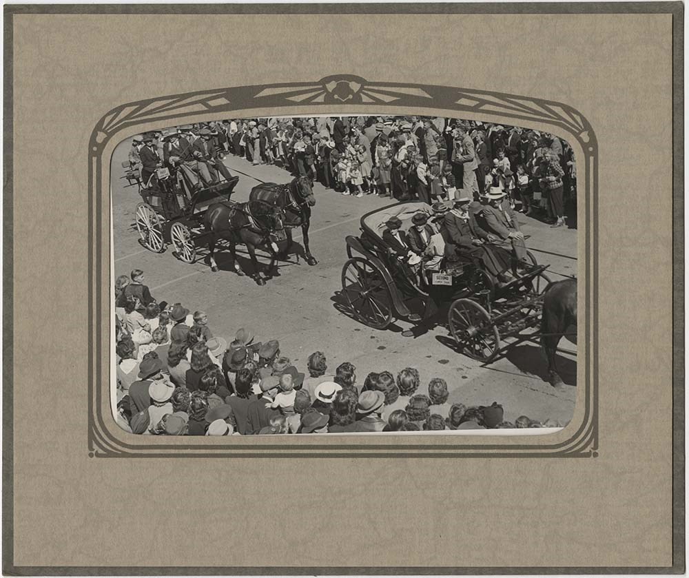
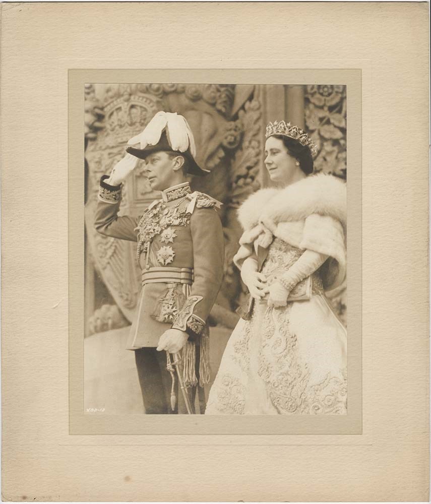
Public events - parade and royal visit
https://archives.whyte.org/en/permalink/descriptions55511
- Part Of
- Luxton family fonds
- Scope & Content
- File consists of two photographs pertaining to public events. Photographs depict horse-drawn carriages riding in a parade procession, date and location unknown; and King George VI and Queen Elizabeth [possibly taken during their visit to Banff in 1939].
- Date Range
- [ca.1920-1940]
- [1939]
- Reference Code
- LUX / I / E4 / PA - 687 to 688
- Description Level
- 5 / File
- GMD
- Photograph
3 images
- Part Of
- Luxton family fonds
- Description Level
- 5 / File
- Fonds Number
- LUX
- Series
- LUX / I / E : Collected material
- Sous-Fonds
- LUX / I : Norman Luxton sous-fonds
- Sub-Series
- LUX / I / E4 : Photographs
- Accession Number
- LUX
- Reference Code
- LUX / I / E4 / PA - 687 to 688
- GMD
- Photograph
- Responsibility
- LUX/I/E4/PA-688 attributed to the Department of Trade and Commerce, Canadian Government
- Date Range
- [ca.1920-1940]
- [1939]
- Physical Description
- 2 photographs : b&w prints ; 30.5 x 35 cm and 24.5 x 20 cm
- Scope & Content
- File consists of two photographs pertaining to public events. Photographs depict horse-drawn carriages riding in a parade procession, date and location unknown; and King George VI and Queen Elizabeth [possibly taken during their visit to Banff in 1939].
- Subject Access
- Community events
- Events
- Parades
- Royal Visit
- Royalty
- Government
- Reproduction Restrictions
- Restrictions may apply
- Language
- English
- Category
- Government
- Title Source
- Title based on contents of file
- Processing Status
- Processed
Images
This material is presented as originally created; it may contain outdated cultural descriptions and
potentially offensive content.
Read more.
Papaschase Indian Reserve land zoning map
https://archives.whyte.org/en/permalink/descriptions55611
- Part Of
- Luxton family fonds
- Scope & Content
- File consists of one zoning map depicting the Papaschase Indian Reserve south of the Saskatchewan River and surrounding area. Map is titled "Plan of Township 52 Range 24 West of the Fourth Meridian".
- Date Range
- 1908
- Reference Code
- LUX / III / C2 / 22
- Description Level
- 5 / File
- GMD
- Map
- Part Of
- Luxton family fonds
- Description Level
- 5 / File
- Fonds Number
- LUX
- Series
- LUX / III / C : Extended family
- Sous-Fonds
- LUX / III : Luxton family sous-fonds
- Sub-Series
- LUX / III / C2 : McDougall and Ross families papers and photographs
- Accession Number
- LUX
- Reference Code
- LUX / III / C2 / 22
- GMD
- Map
- Responsibility
- Produced by the Canadian Department of the Interior
- Date Range
- 1908
- Physical Description
- 1 map : b&w photozincograph print ; 34 x 41 cm
- Scope & Content
- File consists of one zoning map depicting the Papaschase Indian Reserve south of the Saskatchewan River and surrounding area. Map is titled "Plan of Township 52 Range 24 West of the Fourth Meridian".
- Geographic Access
- Canada
- Alberta
- Saskatchewan River
- Edmonton
- Access Restrictions
- Fragile material - handle with caution
- Language
- English
- Title Source
- Title based on contents of file
- Processing Status
- Processed
This material is presented as originally created; it may contain outdated cultural descriptions and
potentially offensive content.
Read more.
Jasper Trails Project - printed trail maps
https://archives.whyte.org/en/permalink/descriptions56152
- Part Of
- Ben Gadd fonds
- Scope & Content
- File consists of printed drafts of trail maps depicting regions near Pyramid Bench, Maligne Canyon, Wabasso Lake and Miette River; and quotes from three printing companies in Alberta. Materials pertain to the updating of trail signage and interpretive information through the Jasper Trails Project.
- Date Range
- 1997-1998
- Reference Code
- M590 / III / D / 106
- Description Level
- 5 / File
- GMD
- Textual record
- Map
- Part Of
- Ben Gadd fonds
- Description Level
- 5 / File
- Fonds Number
- M590
- V810
- S61
- Series
- M590 / III : Published records
- Sous-Fonds
- M590
- Sub-Series
- M590 / III / D : Other contracts and projects
- Accession Number
- 2021.20
- Reference Code
- M590 / III / D / 106
- GMD
- Textual record
- Map
- Date Range
- 1997-1998
- Physical Description
- 0.2 cm of textual records
- Scope & Content
- File consists of printed drafts of trail maps depicting regions near Pyramid Bench, Maligne Canyon, Wabasso Lake and Miette River; and quotes from three printing companies in Alberta. Materials pertain to the updating of trail signage and interpretive information through the Jasper Trails Project.
- Subject Access
- Organization
- Trails
- Research
- Map
- Environment
- Hiking
- Recreation
- Geography
- Parks Canada
- Government
- Geographic Access
- Canada
- Alberta
- Jasper
- Jasper National Park
- Edmonton
- Reproduction Restrictions
- Restrictions may apply
- Language
- English
- Title Source
- Title based on contents of file
- Processing Status
- Processed
This material is presented as originally created; it may contain outdated cultural descriptions and
potentially offensive content.
Read more.
Jasper Trails Project - sign location maps
https://archives.whyte.org/en/permalink/descriptions56154
- Part Of
- Ben Gadd fonds
- Scope & Content
- File consists of maps showing the locations of interpretive signs which were updated and installed as part of the Jasper Trails Project. File includes film positive copies of maps, and related notes and correspondence.
- Date Range
- 1995
- 1997
- Reference Code
- M590 / III / D / 107
- Description Level
- 5 / File
- GMD
- Textual record
- Map
- Part Of
- Ben Gadd fonds
- Description Level
- 5 / File
- Fonds Number
- M590
- V810
- S61
- Series
- M590 / III : Published records
- Sous-Fonds
- M590
- Sub-Series
- M590 / III / D : Other contracts and projects
- Accession Number
- 2021.20
- Reference Code
- M590 / III / D / 107
- GMD
- Textual record
- Map
- Date Range
- 1995
- 1997
- Physical Description
- 1 cm of textual records
- Scope & Content
- File consists of maps showing the locations of interpretive signs which were updated and installed as part of the Jasper Trails Project. File includes film positive copies of maps, and related notes and correspondence.
- Subject Access
- Organization
- Trails
- Research
- Map
- Environment
- Hiking
- Recreation
- Geography
- Parks Canada
- Government
- Geographic Access
- Canada
- Alberta
- Jasper
- Jasper National Park
- Reproduction Restrictions
- Restrictions may apply
- Language
- English
- Title Source
- Title based on contents of file
- Processing Status
- Processed
This material is presented as originally created; it may contain outdated cultural descriptions and
potentially offensive content.
Read more.
Arthur Oliver Wheeler fonds
https://archives.whyte.org/en/permalink/descriptions673
- Part Of
- Arthur Oliver Wheeler fonds
- Scope & Content
- Fonds consists of 53 diaries pertaining to personal life, travel, office work, and Alpine Club of Canada camps. Diaries range in date from 1885 to 1944. Also included are two volumes/scrapbooks compiled by A.O. Wheeler. Both volumes include numerous articles, newspaper clippings, letters, ACC broc…
- Date Range
- 1885-1944
- Reference Code
- M546 / V771
- Description Level
- 1 / Fonds
- GMD
- Photograph
- Album
- Photograph print
- Textual record
- Diary
- Map
- Private record
- Scrapbook
- Part Of
- Arthur Oliver Wheeler fonds
- Description Level
- 1 / Fonds
- Fonds Number
- M 546
- V 771
- Sous-Fonds
- M546 / V771
- Accession Number
- 2016.8598
- 2014.8312
- 8144
- 8160
- Reference Code
- M546 / V771
- Date Range
- 1885-1944
- Physical Description
- 62 vol. of textual material. -- 66 vol. of photograph albums
- History / Biographical
- Arthur Oliver Wheeler (1860-1945) DLS, ALS, BCLS, was born in Ireland, arriving in Canada in 1876. Wheeler was a mountaineer, co-founder of the Alpine Club of Canada (1906), and Dominion Land Surveyor. In 1913, Wheeler was appointed Boundary Commissioner and tasked with photo surveying the Alberta / British Columbia interprovincial boundary.
- Scope & Content
- Fonds consists of 53 diaries pertaining to personal life, travel, office work, and Alpine Club of Canada camps. Diaries range in date from 1885 to 1944. Also included are two volumes/scrapbooks compiled by A.O. Wheeler. Both volumes include numerous articles, newspaper clippings, letters, ACC brochures and notices addressed to ACC members. Volume one covers the period 1902 to 1913; volume two includes materials from 1914 to 1940. A inventory of both volumes, compiled by ACC member Paul Geddes, is also included. Additionally there are 7 volumes of notes corresponding to the photographs A.O. Wheeler took. Photographic material consists of 66 albums which contain approximately 5000 photographs, black and white positive prints from glass negatives, all 12 x 16 cm. The first album is dated 1915, the last 1924. Some of the albums contain a small map printed on linen. Each album contains an index to the photographs taken for the Alberta - British Columbia Interprovincial Boundary photo survey and are organized by Station, Bearing, and Subject.
- Name Access
- Alberta/British Columbia Boundary Survey
- Dominion of Canada Land Surveyor
- Wheeler, Arthur Oliver
- Subject Access
- Environment
- Exploration, discovery and travel
- Government
- Access Restrictions
- No restrictions on access
- Copyright, privacy, commercial use and other restrictions may apply
- Language
- Language is English
- Finding Aid
- electronic finding aid
- Creator
- Wheeler, Arthur Oliver
- Title Source
- Title based on contents of fonds
- Processing Status
- Processed
This material is presented as originally created; it may contain outdated cultural descriptions and
potentially offensive content.
Read more.
Park Warden Photos [1/3]
https://archives.whyte.org/en/permalink/descriptions57487
- Part Of
- Bruno Engler fonds
- Scope & Content
- File pertains to 72 b&w and colour prints depicting various Parks Canada Warden activities, training programs, personnel, and more. Includes shots of wardens participating in climbing rescues (training and real), helicopter operations, fire prevention, avalanche rescue (possibly training), and hors…
- Date Range
- 1954-1975
- Reference Code
- V190 / VI / P / ix / PA - 01 to PA - 72
- Description Level
- 5 / File
- GMD
- Photograph
27 images
- Part Of
- Bruno Engler fonds
- Description Level
- 5 / File
- Fonds Number
- M323 / S40 / V190
- Series
- VI : Retained file, P : Alphabetical order
- Sous-Fonds
- V190
- Sub-Series
- ix : Park Warden Photos
- Accession Number
- 7436
- Reference Code
- V190 / VI / P / ix / PA - 01 to PA - 72
- GMD
- Photograph
- Date Range
- 1954-1975
- Physical Description
- 72 photographs : b&w & col. ; 10.1 x 12.6 cm or smaller
- History / Biographical
- See fonds level description
- Scope & Content
- File pertains to 72 b&w and colour prints depicting various Parks Canada Warden activities, training programs, personnel, and more. Includes shots of wardens participating in climbing rescues (training and real), helicopter operations, fire prevention, avalanche rescue (possibly training), and horseback competitions. Also includes posed portraits (individual and group), backcountry cabins, the Ya Ha Tinda ranch area and horses, and contact sheets of negatives.
- Name Access
- Anderson, Andy
- Auger, Tim
- Davies, Jim
- Fuhrman, Peter
- Hand, Bob
- Kunelius, Rick
- Marak, Bob
- Marty, Sid
- Perren, Walter
- Pittany, Bert
- Rose, Monty
- Skjonsberg, Earl
- Rimmer, Jim
- Vroom, Bill
- Woledge, Jack
- Subject Access
- Accidents
- Activities
- Animals
- Avalanches
- Buildings
- Cabins
- Camps
- Climbing
- Dog Team
- Dogs
- Environment
- Government
- Helicopters
- Hitch throwing
- Horse packing
- Horseback riding
- Horses
- Landscapes
- Mountain warfare training
- Mountaineering
- National parks and reserves
- Parks Canada
- Parks Canada Warden
- Wardens
- Ya-Ha-Tinda Ranch
- Geographic Access
- Banff National Park
- Alberta
- Language
- English
- Related Material
- V190 / VI / P / ix / NA - 01 to NA - 02 V190 / VI / P / ix / NS - 01 to NS - 05
- Creator
- Engler, Bruno
- Title Source
- Original title kept
- Processing Status
- Processed
Images


This material is presented as originally created; it may contain outdated cultural descriptions and
potentially offensive content.
Read more.