Narrow Results By
Papaschase Indian Reserve land zoning map
https://archives.whyte.org/en/permalink/descriptions55611
- Part Of
- Luxton family fonds
- Scope & Content
- File consists of one zoning map depicting the Papaschase Indian Reserve south of the Saskatchewan River and surrounding area. Map is titled "Plan of Township 52 Range 24 West of the Fourth Meridian".
- Date Range
- 1908
- Reference Code
- LUX / III / C2 / 22
- Description Level
- 5 / File
- GMD
- Map
- Part Of
- Luxton family fonds
- Description Level
- 5 / File
- Fonds Number
- LUX
- Series
- LUX / III / C : Extended family
- Sous-Fonds
- LUX / III : Luxton family sous-fonds
- Sub-Series
- LUX / III / C2 : McDougall and Ross families papers and photographs
- Accession Number
- LUX
- Reference Code
- LUX / III / C2 / 22
- GMD
- Map
- Responsibility
- Produced by the Canadian Department of the Interior
- Date Range
- 1908
- Physical Description
- 1 map : b&w photozincograph print ; 34 x 41 cm
- Scope & Content
- File consists of one zoning map depicting the Papaschase Indian Reserve south of the Saskatchewan River and surrounding area. Map is titled "Plan of Township 52 Range 24 West of the Fourth Meridian".
- Geographic Access
- Canada
- Alberta
- Saskatchewan River
- Edmonton
- Access Restrictions
- Fragile material - handle with caution
- Language
- English
- Title Source
- Title based on contents of file
- Processing Status
- Processed
This material is presented as originally created; it may contain outdated cultural descriptions and
potentially offensive content.
Read more.
Jasper Trails Project - printed trail maps
https://archives.whyte.org/en/permalink/descriptions56152
- Part Of
- Ben Gadd fonds
- Scope & Content
- File consists of printed drafts of trail maps depicting regions near Pyramid Bench, Maligne Canyon, Wabasso Lake and Miette River; and quotes from three printing companies in Alberta. Materials pertain to the updating of trail signage and interpretive information through the Jasper Trails Project.
- Date Range
- 1997-1998
- Reference Code
- M590 / III / D / 106
- Description Level
- 5 / File
- GMD
- Textual record
- Map
- Part Of
- Ben Gadd fonds
- Description Level
- 5 / File
- Fonds Number
- M590
- V810
- S61
- Series
- M590 / III : Published records
- Sous-Fonds
- M590
- Sub-Series
- M590 / III / D : Other contracts and projects
- Accession Number
- 2021.20
- Reference Code
- M590 / III / D / 106
- GMD
- Textual record
- Map
- Date Range
- 1997-1998
- Physical Description
- 0.2 cm of textual records
- Scope & Content
- File consists of printed drafts of trail maps depicting regions near Pyramid Bench, Maligne Canyon, Wabasso Lake and Miette River; and quotes from three printing companies in Alberta. Materials pertain to the updating of trail signage and interpretive information through the Jasper Trails Project.
- Subject Access
- Organization
- Trails
- Research
- Map
- Environment
- Hiking
- Recreation
- Geography
- Parks Canada
- Government
- Geographic Access
- Canada
- Alberta
- Jasper
- Jasper National Park
- Edmonton
- Reproduction Restrictions
- Restrictions may apply
- Language
- English
- Title Source
- Title based on contents of file
- Processing Status
- Processed
This material is presented as originally created; it may contain outdated cultural descriptions and
potentially offensive content.
Read more.
Jasper Trails Project - sign location maps
https://archives.whyte.org/en/permalink/descriptions56154
- Part Of
- Ben Gadd fonds
- Scope & Content
- File consists of maps showing the locations of interpretive signs which were updated and installed as part of the Jasper Trails Project. File includes film positive copies of maps, and related notes and correspondence.
- Date Range
- 1995
- 1997
- Reference Code
- M590 / III / D / 107
- Description Level
- 5 / File
- GMD
- Textual record
- Map
- Part Of
- Ben Gadd fonds
- Description Level
- 5 / File
- Fonds Number
- M590
- V810
- S61
- Series
- M590 / III : Published records
- Sous-Fonds
- M590
- Sub-Series
- M590 / III / D : Other contracts and projects
- Accession Number
- 2021.20
- Reference Code
- M590 / III / D / 107
- GMD
- Textual record
- Map
- Date Range
- 1995
- 1997
- Physical Description
- 1 cm of textual records
- Scope & Content
- File consists of maps showing the locations of interpretive signs which were updated and installed as part of the Jasper Trails Project. File includes film positive copies of maps, and related notes and correspondence.
- Subject Access
- Organization
- Trails
- Research
- Map
- Environment
- Hiking
- Recreation
- Geography
- Parks Canada
- Government
- Geographic Access
- Canada
- Alberta
- Jasper
- Jasper National Park
- Reproduction Restrictions
- Restrictions may apply
- Language
- English
- Title Source
- Title based on contents of file
- Processing Status
- Processed
This material is presented as originally created; it may contain outdated cultural descriptions and
potentially offensive content.
Read more.
Maps of Banff and Western Canada
https://archives.whyte.org/en/permalink/descriptions54772
- Part Of
- Luxton family fonds
- Scope & Content
- File consists of 9 printed maps, b&w and col. [including zoning and topographical maps] depicting the Town of Banff and Banff National Park, the Rocky Mountains Forest Reserve, the Moose Mountain region, Medicine Hat, and the province of Alberta. File includes Trail Riders' Map of the Canadian Rock…
- Date Range
- 1912
- 1914
- 1924
- 1926
- 1932
- 1957
- [1970-1980]
- Reference Code
- LUX / II / C5 / 25
- Description Level
- 5 / File
- GMD
- Textual record
- Published record
- Map
- Part Of
- Luxton family fonds
- Description Level
- 5 / File
- Fonds Number
- LUX
- Series
- LUX / II / C : Personal
- Sous-Fonds
- LUX / II : Eleanor Luxton sous-fonds
- Sub-Series
- LUX / II / C5 : Other
- Accession Number
- LUX
- Reference Code
- LUX / II / C5 / 25
- Date Range
- 1912
- 1914
- 1924
- 1926
- 1932
- 1957
- [1970-1980]
- Physical Description
- 9 maps : b&w and col. ; 168 x 71 cm or smaller
- Scope & Content
- File consists of 9 printed maps, b&w and col. [including zoning and topographical maps] depicting the Town of Banff and Banff National Park, the Rocky Mountains Forest Reserve, the Moose Mountain region, Medicine Hat, and the province of Alberta. File includes Trail Riders' Map of the Canadian Rockies which has smaller maps of Waterton Lakes, Glacier, Revelstoke, and other national parks printed on the back. Map of Medicine Hat includes annotated storage envelope with dimensions written on the front.
- Subject Access
- Cartography
- Geography
- Land use
- Government
- Travel
- National parks and reserves
- Geographic Access
- Canada
- Alberta
- Banff
- Banff National Park
- Medicine Hat
- Rocky Mountains
- Glacier National Park
- Revelstoke
- Waterton Lakes National Park
- Reproduction Restrictions
- Restrictions may apply
- Language
- English
- Title Source
- Title based on contents of file
- Processing Status
- Processed
This material is presented as originally created; it may contain outdated cultural descriptions and
potentially offensive content.
Read more.
Four Mountain Parks Planning Program
https://archives.whyte.org/en/permalink/descriptions54919
- Scope & Content
- File consists of a planning scenario draft, response form and information sheet, draft of possible implications, meeting notes and comments, and correspondence between Parks Canada and the Trail Riders of the Canadian Rockies. Content pertains to the Four Mountain Parks Program implemented by Parks…
- Date Range
- 1984-1985
- Reference Code
- M545 / V / 24
- Description Level
- 5 / File
- GMD
- Textual record
- Government record
- Description Level
- 5 / File
- Fonds Number
- M545 / V635
- Series
- M545 / V : Administrative records
- Sous-Fonds
- M545
- Accession Number
- 5939
- Reference Code
- M545 / V / 24
- Date Range
- 1984-1985
- Physical Description
- 2 cm of textual records
- Scope & Content
- File consists of a planning scenario draft, response form and information sheet, draft of possible implications, meeting notes and comments, and correspondence between Parks Canada and the Trail Riders of the Canadian Rockies. Content pertains to the Four Mountain Parks Program implemented by Parks Canada between 1984 and 1985, and related changes adapted by the Trail Riders. Topics include wildlife and resource management, trail use and maintenance, townsite development, hunting and fishing, and other related subjects within Banff, Jasper, Yoho and Kootenay National Parks.
- Notes
- Planning scenario draft has annotations on front cover, annotations and illustrations on second interior page
- Subject Access
- Government
- Environment
- Natural resources
- Townsite development
- Wildlife
- Wildfire
- Conservation
- Ecology
- Fishing
- Forestry
- Hunting
- Land use
- Laws and legislation
- National parks and reserves
- Parks Canada
- Park policy
- Geographic Access
- Canada
- Alberta
- British Columbia
- Banff National Park
- Jasper National Park
- Kootenay National Park
- Yoho National Park
- Language
- English
- Conservation
- Plastic binding removed from planning scenario draft
- Category
- Environment
- Government
- Land, settlement and immigration
- Natural resources
- Sports, recreation and leisure
- Title Source
- Title copied from contents in file
- Processing Status
- Processed
This material is presented as originally created; it may contain outdated cultural descriptions and
potentially offensive content.
Read more.
Banff National Park and Lake Louise maps
https://archives.whyte.org/en/permalink/descriptions54945
- Scope & Content
- File consists of two folded maps and a small clipping [possibly top or bottom portion from a different map or one of maps in file]. One map is of Banff National Park and one is of Lake Louise [1959]. Banff National Park map has black pencil tracings over trail section near the bottom of the map and…
- Date Range
- 1959
- [1960-1970]
- Reference Code
- M545 / V / 53
- Description Level
- 5 / File
- GMD
- Textual record
- Published record
- Map
- Description Level
- 5 / File
- Fonds Number
- M545 / V635
- Series
- M545 / V : Administrative records
- Sous-Fonds
- M545
- Accession Number
- 8235
- Reference Code
- M545 / V / 53
- Date Range
- 1959
- [1960-1970]
- Physical Description
- 0.5 cm of textual records (2 maps ; 60.5 x 57.5 and 60 x 56.5 cm)
- Scope & Content
- File consists of two folded maps and a small clipping [possibly top or bottom portion from a different map or one of maps in file]. One map is of Banff National Park and one is of Lake Louise [1959]. Banff National Park map has black pencil tracings over trail section near the bottom of the map and annotation in bottom right corner which reads "Natural Bridge". Lake Louise map produced by the Government of Canada.
- Subject Access
- Banff National Park
- Environment
- Geography
- Map
- Lake Louise
- Travel
- Government
- National parks and reserves
- Trails
- Geographic Access
- Canada
- Alberta
- Banff National Park
- Lake Louise
- Language
- English
- Conservation
- Clipping stored in mylar due to significant staining and residue from tape
- Items kept folded [not placed in mylar] due to mass production of content and minimal/no annotations
- Title Source
- Title based on contents of file
- Processing Status
- Processed
This material is presented as originally created; it may contain outdated cultural descriptions and
potentially offensive content.
Read more.
- Scope & Content
- File consists of tax forms and documents pertaining to the Trail Riders of the Canadian Rockies, 1978-2008. File includes federal income tax forms, corporate tax forms, GST/HST statements, and annual returns.
- Date Range
- 1978 - 2008
- Reference Code
- M545 / IV / 24 to 30
- Description Level
- 5 / File
- GMD
- Textual record
- Organization record
- Government record
- Description Level
- 5 / File
- Fonds Number
- M545
- V635
- Series
- M545 / IV : Financial records
- Sous-Fonds
- M545
- Accession Number
- 5939
- 8235
- Reference Code
- M545 / IV / 24 to 30
- Date Range
- 1978 - 2008
- Physical Description
- 12 cm of textual records
- Scope & Content
- File consists of tax forms and documents pertaining to the Trail Riders of the Canadian Rockies, 1978-2008. File includes federal income tax forms, corporate tax forms, GST/HST statements, and annual returns.
- Notes
- Contents in file arranged by subject: M545 / IV / 24 : Income tax and registry forms 1978-2008 M545 / IV / 25 : T2 tax forms 1999-2003 M545 / IV / 26 : T2 tax forms 2004-2005 M545 / IV / 27 : Alberta corporate income tax forms 2006 M545 / IV / 28 : GST and HST statements 2006-2008 M545 / IV / 29 : Annual returns 1999-2003 M545 / IV / 30 : Annual returns 2004-2008
- Subject Access
- Administration
- Finances
- Government
- Organizations
- Geographic Access
- Canada
- Alberta
- Language
- English
- Category
- Government
- Title Source
- Title based on contents of file
- Processing Status
- Processed
This material is presented as originally created; it may contain outdated cultural descriptions and
potentially offensive content.
Read more.
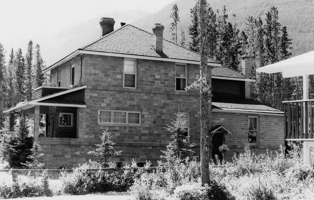
Wheeler House, Alder Avenue, Banff
https://archives.whyte.org/en/permalink/descriptions15080
- Scope & Content
- File pertains to photographs of the Wheeler House.
- Date Range
- 1970
- Reference Code
- V218 / II / PA - 1 to 4
- Description Level
- 5 / File
- GMD
- Government record
- Photograph
1 image
- Description Level
- 5 / File
- Fonds Number
- M187 / V218
- Series
- II. Photographic records
- Sous-Fonds
- V218
- Accession Number
- .
- Reference Code
- V218 / II / PA - 1 to 4
- Date Range
- 1970
- Physical Description
- 1 file of photographs (4 prints)
- History / Biographical
- The Wheeler House was the personal residence of Arthur O. Wheeler, co-founder and first president of the Alpine Club of Canada. The house stood adjacent to the first ACC clubhouse on Sulphur Mountain, located approximately halfway between the Bow River and the Upper Hot Springs. Wheeler constructed the house in 1920, it recieved official heritage recognition in 1994, and was demolished in 2011.
- Scope & Content
- File pertains to photographs of the Wheeler House.
- Name Access
- Wheeler, A. O. (Arthur Oliver)
- Wheeler, Arthur Oliver
- Canadian inventory of historic building survey
- Geographic Access
- Sulphur Mountain
- Banff
- Banff National Park
- Alberta
- Canada
- Language
- NA
- Biographical Source Notes
- https://www.rmotoday.com/local-news/end-of-an-era-for-historic-wheeler-house-in-banff-1560584
- Title Source
- Title based on contents of file
- Processing Status
- Processed
Images

This material is presented as originally created; it may contain outdated cultural descriptions and
potentially offensive content.
Read more.
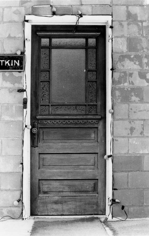
Spray Avenue, Banff
https://archives.whyte.org/en/permalink/descriptions15098
- Scope & Content
- File pertains to photographs of historic buildings located along Spray Avenue in Banff, AB.
- Date Range
- 1970
- Reference Code
- V218 / II / PA - 350 to 386
- Description Level
- 5 / File
- GMD
- Government record
- Photograph
2 images
- Description Level
- 5 / File
- Fonds Number
- M187 / V200
- Series
- II. Photographic records
- Sous-Fonds
- V200
- Accession Number
- .
- Reference Code
- V218 / II / PA - 350 to 386
- Date Range
- 1970
- Physical Description
- 7 files of photographs (37 prints)
- History / Biographical
- See fonds level description
- Scope & Content
- File pertains to photographs of historic buildings located along Spray Avenue in Banff, AB.
- Notes
- List of files:
- 114 Spray Avenue, Banff (V218 / II / PA - 350-355)
- 118 Spray Avenue, Banff (V218 / II / PA - 356-360)
- 119 Spray Avenue, Banff (V218 / II / PA - 361-365)
- 125 Spray Avenue, Banff (V218 / II / PA - 366-369)
- 127 Spray Avenue, Banff (V218 / II / PA - 370-374)
- 131 Spray Avenue, Banff (V218 / II / PA - 375-381)
- 137 Spray Avenue, Banff (V218 / II / PA - 382-386)
- Name Access
- Canadian inventory of historic building survey
- Geographic Access
- Sulphur Mountain
- Banff
- Banff National Park
- Alberta
- Canada
- Language
- NA
- Related Material
- For textual records re Spray Avenue buildings, see: M187 / 25
- Title Source
- Title based on contents of file
- Processing Status
- Processed
Images
This material is presented as originally created; it may contain outdated cultural descriptions and
potentially offensive content.
Read more.
Financial assistance, other university records
https://archives.whyte.org/en/permalink/descriptions55778
- Part Of
- Ben Gadd fonds
- Scope & Content
- File consists of documents pertaining to Ben Gadd's financial assistance and other university records. File includes Ben's student ID cards for the University of Colorado, University of Calgary, and University of Lethbridge; grade reports, tuition receipts, student loan cheques and invoices; schola…
- Date Range
- 1966-1972
- Reference Code
- M590 / I / B / 16
- Description Level
- 5 / File
- GMD
- Textual record
- Government record
- Part Of
- Ben Gadd fonds
- Description Level
- 5 / File
- Fonds Number
- M590
- V810
- S61
- Series
- M590 / I : Personal records
- Sous-Fonds
- M590
- Sub-Series
- M590 / I / B : Education and early writing
- Accession Number
- 2021.20
- Reference Code
- M590 / I / B / 16
- Date Range
- 1966-1972
- Physical Description
- 1.5 cm of textual records
- Scope & Content
- File consists of documents pertaining to Ben Gadd's financial assistance and other university records. File includes Ben's student ID cards for the University of Colorado, University of Calgary, and University of Lethbridge; grade reports, tuition receipts, student loan cheques and invoices; scholarship and student loan application forms; school registration forms; and other related documents.
- Name Access
- Gadd, Ben
- Subject Access
- Education
- University
- Finances
- Government
- School
- Geographic Access
- Canada
- Alberta
- Calgary
- Lethbridge
- United States of America
- Colorado
- Reproduction Restrictions
- Restrictions may apply
- Language
- English
- Category
- Education
- Government
- Title Source
- Title based on contents of file
- Processing Status
- Processed
This material is presented as originally created; it may contain outdated cultural descriptions and
potentially offensive content.
Read more.