Narrow Results By
Jasper Trails Project - printed trail maps
https://archives.whyte.org/en/permalink/descriptions56152
- Part Of
- Ben Gadd fonds
- Scope & Content
- File consists of printed drafts of trail maps depicting regions near Pyramid Bench, Maligne Canyon, Wabasso Lake and Miette River; and quotes from three printing companies in Alberta. Materials pertain to the updating of trail signage and interpretive information through the Jasper Trails Project.
- Date Range
- 1997-1998
- Reference Code
- M590 / III / D / 106
- Description Level
- 5 / File
- GMD
- Textual record
- Map
- Part Of
- Ben Gadd fonds
- Description Level
- 5 / File
- Fonds Number
- M590
- V810
- S61
- Series
- M590 / III : Published records
- Sous-Fonds
- M590
- Sub-Series
- M590 / III / D : Other contracts and projects
- Accession Number
- 2021.20
- Reference Code
- M590 / III / D / 106
- GMD
- Textual record
- Map
- Date Range
- 1997-1998
- Physical Description
- 0.2 cm of textual records
- Scope & Content
- File consists of printed drafts of trail maps depicting regions near Pyramid Bench, Maligne Canyon, Wabasso Lake and Miette River; and quotes from three printing companies in Alberta. Materials pertain to the updating of trail signage and interpretive information through the Jasper Trails Project.
- Subject Access
- Organization
- Trails
- Research
- Map
- Environment
- Hiking
- Recreation
- Geography
- Parks Canada
- Government
- Geographic Access
- Canada
- Alberta
- Jasper
- Jasper National Park
- Edmonton
- Reproduction Restrictions
- Restrictions may apply
- Language
- English
- Title Source
- Title based on contents of file
- Processing Status
- Processed
This material is presented as originally created; it may contain outdated cultural descriptions and
potentially offensive content.
Read more.
Jasper Trails Project - sign location maps
https://archives.whyte.org/en/permalink/descriptions56154
- Part Of
- Ben Gadd fonds
- Scope & Content
- File consists of maps showing the locations of interpretive signs which were updated and installed as part of the Jasper Trails Project. File includes film positive copies of maps, and related notes and correspondence.
- Date Range
- 1995
- 1997
- Reference Code
- M590 / III / D / 107
- Description Level
- 5 / File
- GMD
- Textual record
- Map
- Part Of
- Ben Gadd fonds
- Description Level
- 5 / File
- Fonds Number
- M590
- V810
- S61
- Series
- M590 / III : Published records
- Sous-Fonds
- M590
- Sub-Series
- M590 / III / D : Other contracts and projects
- Accession Number
- 2021.20
- Reference Code
- M590 / III / D / 107
- GMD
- Textual record
- Map
- Date Range
- 1995
- 1997
- Physical Description
- 1 cm of textual records
- Scope & Content
- File consists of maps showing the locations of interpretive signs which were updated and installed as part of the Jasper Trails Project. File includes film positive copies of maps, and related notes and correspondence.
- Subject Access
- Organization
- Trails
- Research
- Map
- Environment
- Hiking
- Recreation
- Geography
- Parks Canada
- Government
- Geographic Access
- Canada
- Alberta
- Jasper
- Jasper National Park
- Reproduction Restrictions
- Restrictions may apply
- Language
- English
- Title Source
- Title based on contents of file
- Processing Status
- Processed
This material is presented as originally created; it may contain outdated cultural descriptions and
potentially offensive content.
Read more.
Maps of Banff and Western Canada
https://archives.whyte.org/en/permalink/descriptions54772
- Part Of
- Luxton family fonds
- Scope & Content
- File consists of 9 printed maps, b&w and col. [including zoning and topographical maps] depicting the Town of Banff and Banff National Park, the Rocky Mountains Forest Reserve, the Moose Mountain region, Medicine Hat, and the province of Alberta. File includes Trail Riders' Map of the Canadian Rock…
- Date Range
- 1912
- 1914
- 1924
- 1926
- 1932
- 1957
- [1970-1980]
- Reference Code
- LUX / II / C5 / 25
- Description Level
- 5 / File
- GMD
- Textual record
- Published record
- Map
- Part Of
- Luxton family fonds
- Description Level
- 5 / File
- Fonds Number
- LUX
- Series
- LUX / II / C : Personal
- Sous-Fonds
- LUX / II : Eleanor Luxton sous-fonds
- Sub-Series
- LUX / II / C5 : Other
- Accession Number
- LUX
- Reference Code
- LUX / II / C5 / 25
- Date Range
- 1912
- 1914
- 1924
- 1926
- 1932
- 1957
- [1970-1980]
- Physical Description
- 9 maps : b&w and col. ; 168 x 71 cm or smaller
- Scope & Content
- File consists of 9 printed maps, b&w and col. [including zoning and topographical maps] depicting the Town of Banff and Banff National Park, the Rocky Mountains Forest Reserve, the Moose Mountain region, Medicine Hat, and the province of Alberta. File includes Trail Riders' Map of the Canadian Rockies which has smaller maps of Waterton Lakes, Glacier, Revelstoke, and other national parks printed on the back. Map of Medicine Hat includes annotated storage envelope with dimensions written on the front.
- Subject Access
- Cartography
- Geography
- Land use
- Government
- Travel
- National parks and reserves
- Geographic Access
- Canada
- Alberta
- Banff
- Banff National Park
- Medicine Hat
- Rocky Mountains
- Glacier National Park
- Revelstoke
- Waterton Lakes National Park
- Reproduction Restrictions
- Restrictions may apply
- Language
- English
- Title Source
- Title based on contents of file
- Processing Status
- Processed
This material is presented as originally created; it may contain outdated cultural descriptions and
potentially offensive content.
Read more.
Banff National Park and Lake Louise maps
https://archives.whyte.org/en/permalink/descriptions54945
- Scope & Content
- File consists of two folded maps and a small clipping [possibly top or bottom portion from a different map or one of maps in file]. One map is of Banff National Park and one is of Lake Louise [1959]. Banff National Park map has black pencil tracings over trail section near the bottom of the map and…
- Date Range
- 1959
- [1960-1970]
- Reference Code
- M545 / V / 53
- Description Level
- 5 / File
- GMD
- Textual record
- Published record
- Map
- Description Level
- 5 / File
- Fonds Number
- M545 / V635
- Series
- M545 / V : Administrative records
- Sous-Fonds
- M545
- Accession Number
- 8235
- Reference Code
- M545 / V / 53
- Date Range
- 1959
- [1960-1970]
- Physical Description
- 0.5 cm of textual records (2 maps ; 60.5 x 57.5 and 60 x 56.5 cm)
- Scope & Content
- File consists of two folded maps and a small clipping [possibly top or bottom portion from a different map or one of maps in file]. One map is of Banff National Park and one is of Lake Louise [1959]. Banff National Park map has black pencil tracings over trail section near the bottom of the map and annotation in bottom right corner which reads "Natural Bridge". Lake Louise map produced by the Government of Canada.
- Subject Access
- Banff National Park
- Environment
- Geography
- Map
- Lake Louise
- Travel
- Government
- National parks and reserves
- Trails
- Geographic Access
- Canada
- Alberta
- Banff National Park
- Lake Louise
- Language
- English
- Conservation
- Clipping stored in mylar due to significant staining and residue from tape
- Items kept folded [not placed in mylar] due to mass production of content and minimal/no annotations
- Title Source
- Title based on contents of file
- Processing Status
- Processed
This material is presented as originally created; it may contain outdated cultural descriptions and
potentially offensive content.
Read more.
Papaschase Indian Reserve land zoning map
https://archives.whyte.org/en/permalink/descriptions55611
- Part Of
- Luxton family fonds
- Scope & Content
- File consists of one zoning map depicting the Papaschase Indian Reserve south of the Saskatchewan River and surrounding area. Map is titled "Plan of Township 52 Range 24 West of the Fourth Meridian".
- Date Range
- 1908
- Reference Code
- LUX / III / C2 / 22
- Description Level
- 5 / File
- GMD
- Map
- Part Of
- Luxton family fonds
- Description Level
- 5 / File
- Fonds Number
- LUX
- Series
- LUX / III / C : Extended family
- Sous-Fonds
- LUX / III : Luxton family sous-fonds
- Sub-Series
- LUX / III / C2 : McDougall and Ross families papers and photographs
- Accession Number
- LUX
- Reference Code
- LUX / III / C2 / 22
- GMD
- Map
- Responsibility
- Produced by the Canadian Department of the Interior
- Date Range
- 1908
- Physical Description
- 1 map : b&w photozincograph print ; 34 x 41 cm
- Scope & Content
- File consists of one zoning map depicting the Papaschase Indian Reserve south of the Saskatchewan River and surrounding area. Map is titled "Plan of Township 52 Range 24 West of the Fourth Meridian".
- Geographic Access
- Canada
- Alberta
- Saskatchewan River
- Edmonton
- Access Restrictions
- Fragile material - handle with caution
- Language
- English
- Title Source
- Title based on contents of file
- Processing Status
- Processed
This material is presented as originally created; it may contain outdated cultural descriptions and
potentially offensive content.
Read more.
Park Warden Photos [1/3]
https://archives.whyte.org/en/permalink/descriptions57487
- Part Of
- Bruno Engler fonds
- Scope & Content
- File pertains to 72 b&w and colour prints depicting various Parks Canada Warden activities, training programs, personnel, and more. Includes shots of wardens participating in climbing rescues (training and real), helicopter operations, fire prevention, avalanche rescue (possibly training), and hors…
- Date Range
- 1954-1975
- Reference Code
- V190 / VI / P / ix / PA - 01 to PA - 72
- Description Level
- 5 / File
- GMD
- Photograph
27 images
- Part Of
- Bruno Engler fonds
- Description Level
- 5 / File
- Fonds Number
- M323 / S40 / V190
- Series
- VI : Retained file, P : Alphabetical order
- Sous-Fonds
- V190
- Sub-Series
- ix : Park Warden Photos
- Accession Number
- 7436
- Reference Code
- V190 / VI / P / ix / PA - 01 to PA - 72
- GMD
- Photograph
- Date Range
- 1954-1975
- Physical Description
- 72 photographs : b&w & col. ; 10.1 x 12.6 cm or smaller
- History / Biographical
- See fonds level description
- Scope & Content
- File pertains to 72 b&w and colour prints depicting various Parks Canada Warden activities, training programs, personnel, and more. Includes shots of wardens participating in climbing rescues (training and real), helicopter operations, fire prevention, avalanche rescue (possibly training), and horseback competitions. Also includes posed portraits (individual and group), backcountry cabins, the Ya Ha Tinda ranch area and horses, and contact sheets of negatives.
- Name Access
- Anderson, Andy
- Auger, Tim
- Davies, Jim
- Fuhrman, Peter
- Hand, Bob
- Kunelius, Rick
- Marak, Bob
- Marty, Sid
- Perren, Walter
- Pittany, Bert
- Rose, Monty
- Skjonsberg, Earl
- Rimmer, Jim
- Vroom, Bill
- Woledge, Jack
- Subject Access
- Accidents
- Activities
- Animals
- Avalanches
- Buildings
- Cabins
- Camps
- Climbing
- Dog Team
- Dogs
- Environment
- Government
- Helicopters
- Hitch throwing
- Horse packing
- Horseback riding
- Horses
- Landscapes
- Mountain warfare training
- Mountaineering
- National parks and reserves
- Parks Canada
- Parks Canada Warden
- Wardens
- Ya-Ha-Tinda Ranch
- Geographic Access
- Banff National Park
- Alberta
- Language
- English
- Related Material
- V190 / VI / P / ix / NA - 01 to NA - 02 V190 / VI / P / ix / NS - 01 to NS - 05
- Creator
- Engler, Bruno
- Title Source
- Original title kept
- Processing Status
- Processed
Images


This material is presented as originally created; it may contain outdated cultural descriptions and
potentially offensive content.
Read more.
Park Warden Photos [2/3]
https://archives.whyte.org/en/permalink/descriptions57488
- Part Of
- Bruno Engler fonds
- Scope & Content
- File pertains to 70 b&w and colour prints depicting various Parks Canada Warden activities, training programs, personnel, and more. Includes shots of wardens participating in climbing rescues (training and real), helicopter operations, fire prevention, avalanche rescue (possibly training), and hors…
- Date Range
- 1954-1975
- Reference Code
- V190 / VI / P / ix / PA - 73 to PA - 143
- Description Level
- 5 / File
- GMD
- Photograph
15 images
- Part Of
- Bruno Engler fonds
- Description Level
- 5 / File
- Fonds Number
- M323 / S40 / V190
- Series
- VI : Retained file, P : Alphabetical order
- Sous-Fonds
- V190
- Sub-Series
- ix : Park Warden Photos
- Accession Number
- 7436
- Reference Code
- V190 / VI / P / ix / PA - 73 to PA - 143
- GMD
- Photograph
- Date Range
- 1954-1975
- Physical Description
- 70 photographs : b&w & col. ; 21.2 x 16.1 cm or smaller
- History / Biographical
- See fonds level description
- Scope & Content
- File pertains to 70 b&w and colour prints depicting various Parks Canada Warden activities, training programs, personnel, and more. Includes shots of wardens participating in climbing rescues (training and real), helicopter operations, fire prevention, avalanche rescue (possibly training), and horseback competitions. Also includes posed portraits (individual and group), backcountry cabins, and the Ya Ha Tinda ranch area and horses
- Name Access
- Anderson, Andy
- Auger, Tim
- Davies, Jim
- Fuhrman, Peter
- Hand, Bob
- Kunelius, Rick
- Marak, Bob
- Marty, Sid
- Perren, Walter
- Pittany, Bert
- Rose, Monty
- Skjonsberg, Earl
- Rimmer, Jim
- Vroom, Bill
- Woledge, Jack
- Subject Access
- Accidents
- Activities
- Animals
- Avalanches
- Buildings
- Cabins
- Camps
- Climbing
- Dog Team
- Dogs
- Environment
- Government
- Helicopters
- Hitch throwing
- Horse packing
- Horseback riding
- Horses
- Landscapes
- Mountain warfare training
- Mountaineering
- National parks and reserves
- Parks Canada
- Parks Canada Warden
- Wardens
- Ya-Ha-Tinda Ranch
- Geographic Access
- Banff National Park
- Alberta
- Language
- English
- Related Material
- V190 / VI / P / ix / NA - 01 to NA - 02 V190 / VI / P / ix / NS - 01 to NS - 05
- Creator
- Engler, Bruno
- Title Source
- Original title kept
- Processing Status
- Processed
Images


This material is presented as originally created; it may contain outdated cultural descriptions and
potentially offensive content.
Read more.
Park Warden Photos [3/3]
https://archives.whyte.org/en/permalink/descriptions57489
- Part Of
- Bruno Engler fonds
- Scope & Content
- File pertains to 59 b&w and colour prints depicting various Parks Canada Warden activities, training programs, personnel, and more. Includes shots of wardens participating in climbing rescues (training and real), helicopter operations, fire prevention, avalanche rescue (possibly training), and hors…
- Date Range
- 1954-1975
- Reference Code
- V190 / VI / P / ix / PA - 144 to PA - 203
- Description Level
- 5 / File
- GMD
- Photograph
9 images
- Part Of
- Bruno Engler fonds
- Description Level
- 5 / File
- Fonds Number
- M323 / S40 / V190
- Series
- VI : Retained file, P : Alphabetical order
- Sous-Fonds
- V190
- Sub-Series
- ix : Park Warden Photos
- Accession Number
- 7436
- Reference Code
- V190 / VI / P / ix / PA - 144 to PA - 203
- GMD
- Photograph
- Date Range
- 1954-1975
- Physical Description
- 59 photographs : b&w & col. ; 32.9 x 25.1 cm or smaller
- History / Biographical
- See fonds level description
- Scope & Content
- File pertains to 59 b&w and colour prints depicting various Parks Canada Warden activities, training programs, personnel, and more. Includes shots of wardens participating in climbing rescues (training and real), helicopter operations, fire prevention, avalanche rescue (possibly training), and horseback competitions. Also includes posed portraits (individual and group), backcountry cabins, the Ya Ha Tinda ranch area and horses, and contact sheets of negatives.
- Name Access
- Anderson, Andy
- Auger, Tim
- Davies, Jim
- Fuhrman, Peter
- Hand, Bob
- Kunelius, Rick
- Marak, Bob
- Marty, Sid
- Perren, Walter
- Pittany, Bert
- Rose, Monty
- Skjonsberg, Earl
- Rimmer, Jim
- Vroom, Bill
- Woledge, Jack
- Subject Access
- Accidents
- Activities
- Animals
- Avalanches
- Buildings
- Cabins
- Camps
- Climbing
- Dog Team
- Dogs
- Environment
- Government
- Helicopters
- Hitch throwing
- Horse packing
- Horseback riding
- Horses
- Landscapes
- Mountain warfare training
- Mountaineering
- National parks and reserves
- Parks Canada
- Parks Canada Warden
- Wardens
- Ya-Ha-Tinda Ranch
- Geographic Access
- Banff National Park
- Alberta
- Language
- English
- Related Material
- V190 / VI / P / ix / NA - 01 to NA - 02 V190 / VI / P / ix / NS - 01 to NS - 05
- Creator
- Engler, Bruno
- Title Source
- Original title kept
- Processing Status
- Processed
Images


This material is presented as originally created; it may contain outdated cultural descriptions and
potentially offensive content.
Read more.
Warden Arming Issue
https://archives.whyte.org/en/permalink/descriptions56410
- Part Of
- Ben Gadd fonds
- Scope & Content
- File consists of photographs taken by Ben Gadd and Jurgen Deagle pertaining to illegal bush camping near Jasper. Photographs were collected as part of discussions with Parks Canada concerning the arming of certified Park Wardens with firearms and added law enforcement duties for some Parks Canada s…
- Date Range
- 2001
- Reference Code
- V810 / I / C / PA - 78 to 88
- Description Level
- 5 / File
- GMD
- Photograph
- Part Of
- Ben Gadd fonds
- Description Level
- 5 / File
- Fonds Number
- M590
- V810
- S61
- Series
- V810 / I : Personal records
- Sous-Fonds
- V810
- Sub-Series
- V810 / I / C : Personal interest files
- Accession Number
- 2021.20
- Reference Code
- V810 / I / C / PA - 78 to 88
- GMD
- Photograph
- Responsibility
- Produced by Ben Gadd, Jurgen Deagle
- Date Range
- 2001
- Physical Description
- 11 photographs : col. prints ; 15 x 10 cm
- Scope & Content
- File consists of photographs taken by Ben Gadd and Jurgen Deagle pertaining to illegal bush camping near Jasper. Photographs were collected as part of discussions with Parks Canada concerning the arming of certified Park Wardens with firearms and added law enforcement duties for some Parks Canada staff.
- Notes
- Photographs in file are annotated by Ben Gadd
- Name Access
- Gadd, Ben
- Deagle, Jurgen
- Subject Access
- Government
- Laws and legislation
- Park policy
- Parks
- Parks Canada
- Parks Canada Warden
- Environment
- Camping
- National parks and reserves
- Geographic Access
- Canada
- Alberta
- Jasper National Park
- Language
- English
- Related Material
- M590 / I / C / 167
- V810 / I / C / NA - 18 to 20
- Category
- Government
- Environment
- Law and justice
- Title Source
- Original title used
- Processing Status
- Processed
This material is presented as originally created; it may contain outdated cultural descriptions and
potentially offensive content.
Read more.
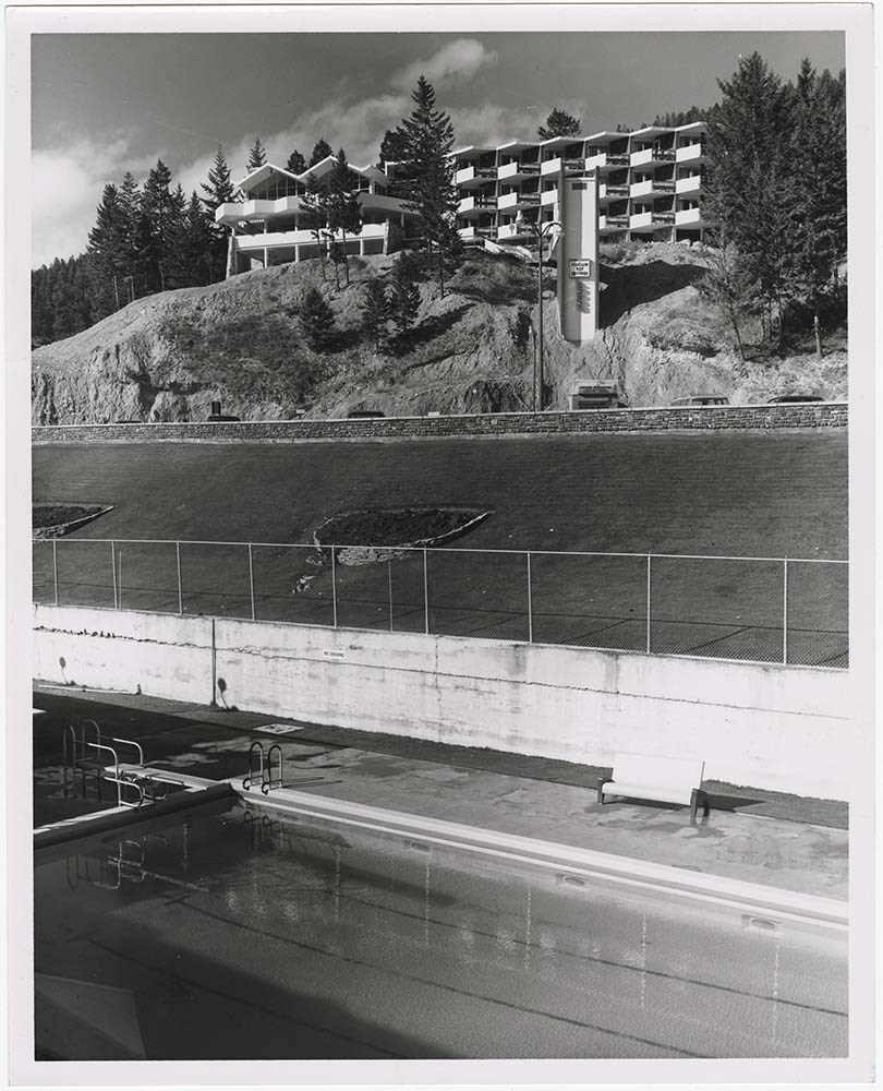
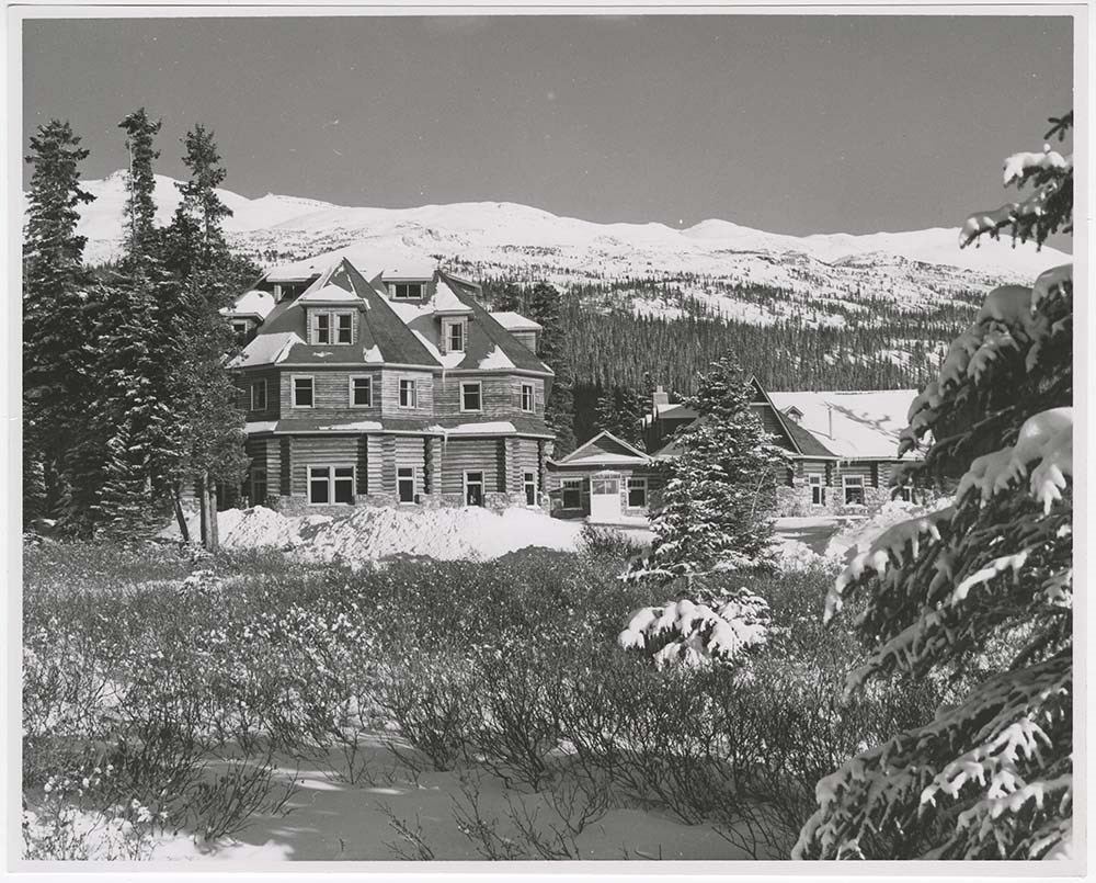
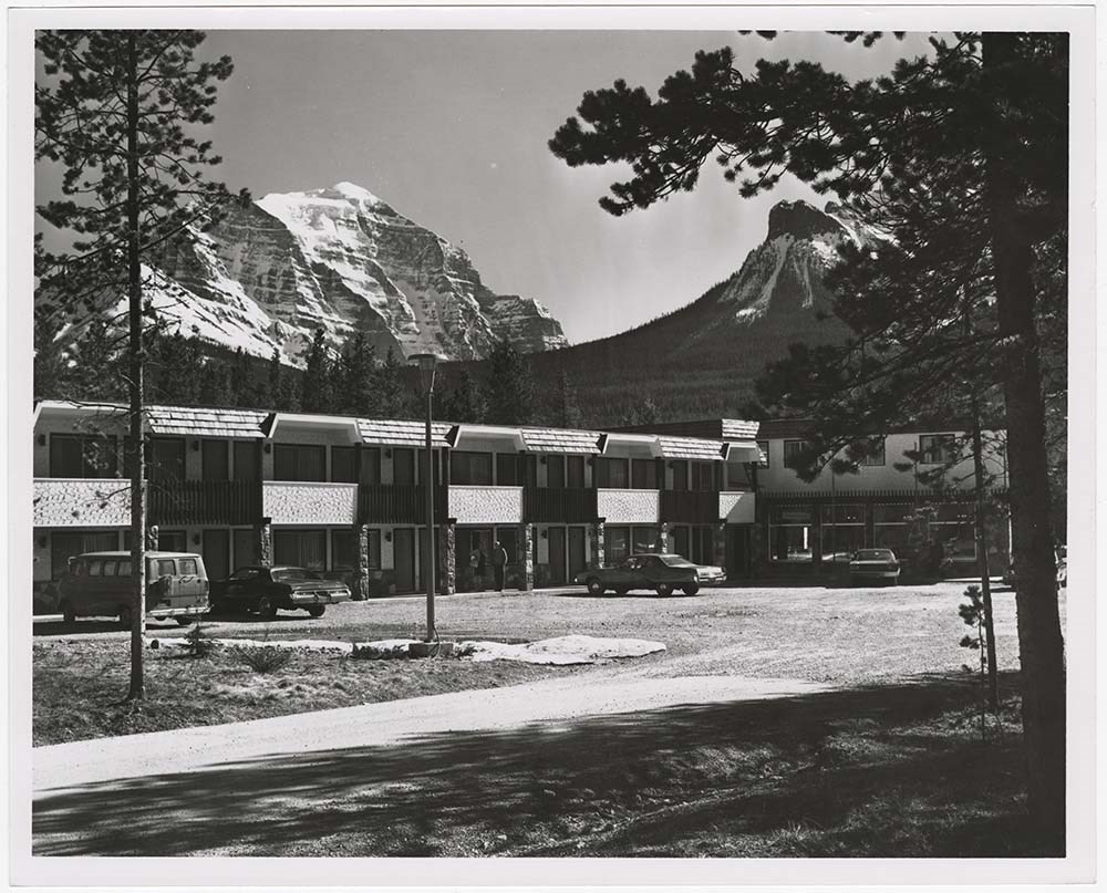
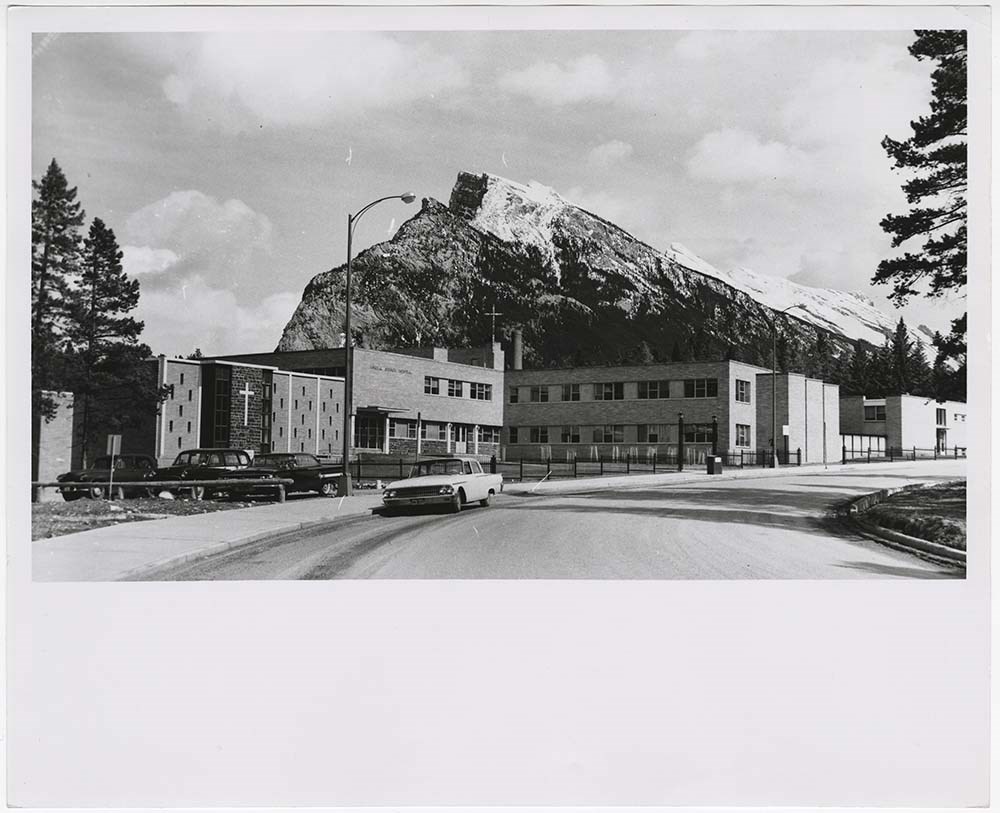
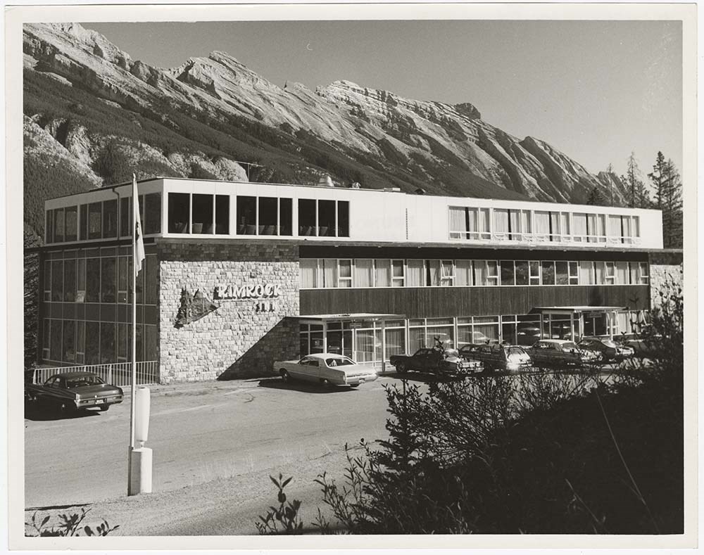
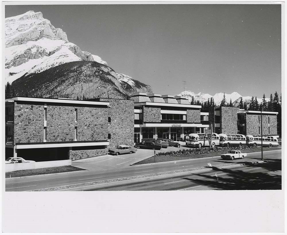
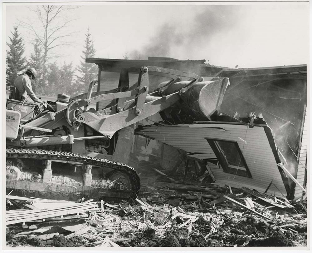
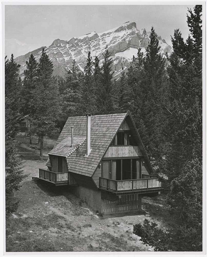
Buildings and Hotels
https://archives.whyte.org/en/permalink/descriptions56793
- Part Of
- Bruno Engler fonds
- Scope & Content
- File pertains to 68 b&w prints of various buildings' interiors and exteriors around Banff, Edmonton, Radium, and Wapta. Includes St. Paul's Presbyterian Church, Mineral Springs Hospital (located on the south side of the Bow River), the Voyager Inn, the Rimrock Inn, the Parks Canada Administration B…
- Date Range
- [ca. 1960-1977]
- Reference Code
- V190 / VI / B / vii / PA - 01 to PA - 68
- Description Level
- 5 / File
- GMD
- Photograph
10 images
- Part Of
- Bruno Engler fonds
- Description Level
- 5 / File
- Fonds Number
- M323 / S40 / V190
- Series
- VI : Retained file, B : Alphabetical order
- Sous-Fonds
- V190
- Sub-Series
- vii : Buildings and Hotels
- Accession Number
- 7436
- Reference Code
- V190 / VI / B / vii / PA - 01 to PA - 68
- GMD
- Photograph
- Date Range
- [ca. 1960-1977]
- Physical Description
- 68 photographs : b&w ; 25.2 x 20.2 cm or smaller
- History / Biographical
- See fonds level description
- Scope & Content
- File pertains to 68 b&w prints of various buildings' interiors and exteriors around Banff, Edmonton, Radium, and Wapta. Includes St. Paul's Presbyterian Church, Mineral Springs Hospital (located on the south side of the Bow River), the Voyager Inn, the Rimrock Inn, the Parks Canada Administration Building, Num-ti-Jaw Lodge, the lobby of the Bank of Montreal, various unidentified houses (both intact and being demolished), a federal building in Edmonton, the Radium Hot Springs Inn, the Wapta Inn, alters and shrines (interior and exterior), and the interiors of various hotels - including public spaces and rooms.
- Subject Access
- Buildings
- Businesses
- Cabins
- Churches
- Hot Springs
- Hotels
- Government
- Mountains
- Parks Canada
- Rivers
- Roads
- Winter
- Geographic Access
- Banff
- Lake Louise
- Banff National Park
- Edmonton
- Alberta
- Radium
- British Columbia
- Language
- English
- Related Material
- V190 / VI / B / vii / NA - 01 to NA - 04
- Creator
- Engler, Bruno
- Title Source
- Original title kept
- Processing Status
- Processed
Images

This material is presented as originally created; it may contain outdated cultural descriptions and
potentially offensive content.
Read more.