Narrow Results By
- Date
- 1917 – 1966
- Medium
- graphite; ink on paper
- Catalogue Number
- WyP.03.516
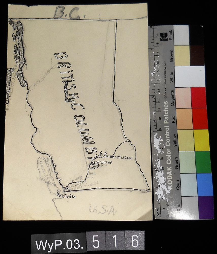
- Description
- A pencil and ink drawing of a map of British Columbia. Notable is Highway 1 and the significant places through which it passes.
1 image
- Title
- B.C.
- Date
- 1917 – 1966
- Medium
- graphite; ink on paper
- Dimensions
- 22.5 x 15.1 cm
- Description
- A pencil and ink drawing of a map of British Columbia. Notable is Highway 1 and the significant places through which it passes.
- Credit
- Gift of Catharine Robb Whyte, O. C., Banff, 1975
- Catalogue Number
- WyP.03.516
Images
This material is presented as originally created; it may contain outdated cultural descriptions and
potentially offensive content.
Read more.
[Hope 92 H - B.C.]
https://archives.whyte.org/en/permalink/catalogue24067
- Medium
- Library - Maps and blueprints (unannotated; published)
- Map
- Published Date
- 1970
- Publisher
- Dept. of Energy, Mines and Resources
- Call Number
- NTS
- 92H
- Publisher
- Dept. of Energy, Mines and Resources
- Published Date
- 1970
- Physical Description
- Colour
- Scale
- Scale: 1:250,000
- Relief: Contour interval 500 ft.
- Subjects
- Hope 92 H - B.C.
- Notes
- National Topographic System
- Accession Number
- 3000
- Call Number
- NTS
- 92H
- Collection
- Archives Library
This material is presented as originally created; it may contain outdated cultural descriptions and
potentially offensive content.
Read more.
[Hope 92H/6 West - B.C.]
https://archives.whyte.org/en/permalink/catalogue23665
- Medium
- Library - Maps and blueprints (unannotated; published)
- Map
- Published Date
- 1957
- Publisher
- Dept. of Mines & Technical Surveys
- Call Number
- NTS
- 92H/6W
- Publisher
- Dept. of Mines & Technical Surveys
- Published Date
- 1957
- Physical Description
- Colour
- Scale
- Scale: 1:50,000
- Relief: Contour interval 100 ft.
- Subjects
- Hope 92H/6 West - B.C.
- Notes
- National Topographic System
- Accession Number
- 7000
- Call Number
- NTS
- 92H/6W
- Collection
- Archives Library
This material is presented as originally created; it may contain outdated cultural descriptions and
potentially offensive content.
Read more.
[Hope 92H/6E - B.C.]
https://archives.whyte.org/en/permalink/catalogue23664
- Medium
- Library - Maps and blueprints (unannotated; published)
- Map
- Published Date
- 1968
- Publisher
- Dept. of Energy, Mines & Resources
- Call Number
- NTS
- 92H/6E
- Publisher
- Dept. of Energy, Mines & Resources
- Published Date
- 1968
- Physical Description
- Colour
- Scale
- Scale: 1:50,000
- Relief: Contour interval 100 ft.
- Subjects
- Hope 92H/6E - B.C.
- Notes
- National Topographic System
- Accession Number
- 7000
- Call Number
- NTS
- 92H/6E
- Collection
- Archives Library
This material is presented as originally created; it may contain outdated cultural descriptions and
potentially offensive content.
Read more.
The Hope Airfield, Looking West
https://archives.whyte.org/en/permalink/artifactlae.05.40
- Date
- 1947
- Medium
- watercolour on paper
- Catalogue Number
- LaE.05.40
- Description
- E. Lamarque 1946-47”
1 image
- Title
- The Hope Airfield, Looking West
- Date
- 1947
- Medium
- watercolour on paper
- Dimensions
- 17.8 x 25.3 cm
- Description
- E. Lamarque 1946-47”
- Subject
- landscape
- mountains
- airfield
- Hope
- Ernest Lamarque
- Credit
- Gift of Ernest Lamarque (Estate), 1971
- Catalogue Number
- LaE.05.40
Images

This material is presented as originally created; it may contain outdated cultural descriptions and
potentially offensive content.
Read more.
[Hudson Hope]
https://archives.whyte.org/en/permalink/catalogue23980
- Medium
- Library - Maps and blueprints (unannotated; published)
- Map
- Published Date
- 1953
- Publisher
- Dept. of Mines & Technical Surveys
- Call Number
- NTS
- 94A/SW
- Publisher
- Dept. of Mines & Technical Surveys
- Published Date
- 1953
- Physical Description
- 1 map : col
- Scale
- Scale: 1:126,720
- Subjects
- Hudson Hope
- Notes
- National Topographic System
- Accession Number
- 3000
- Call Number
- NTS
- 94A/SW
- Collection
- Archives Library
This material is presented as originally created; it may contain outdated cultural descriptions and
potentially offensive content.
Read more.
[Hudson Hope 94SE]
https://archives.whyte.org/en/permalink/catalogue24187
- Medium
- Library - Maps and blueprints (unannotated; published)
- Map
- Published Date
- 1960
- Publisher
- Dept. of Mines and Technical Surveys
- Call Number
- NTS
- 94SE
- Publisher
- Dept. of Mines and Technical Surveys
- Published Date
- 1960
- Scale
- Scale: 1:500,000
- Altitude tints
- Subjects
- Hudson Hope
- Notes
- National Topographic System
- Accession Number
- 3000
- Call Number
- NTS
- 94SE
- Collection
- Archives Library
This material is presented as originally created; it may contain outdated cultural descriptions and
potentially offensive content.
Read more.
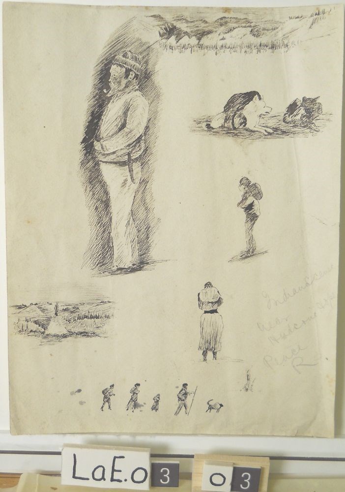
Indian Scenes near Hudson’s Hope Peace River
https://archives.whyte.org/en/permalink/artifactlae.03.03
- Date
- n.d.
- Medium
- pen; ink on paper
- Catalogue Number
- LaE.03.03
- Description
- In pencil brh: Indian scene near Hudson’s Hope, Peace R.
1 image
- Title
- Indian Scenes near Hudson’s Hope Peace River
- Date
- n.d.
- Medium
- pen; ink on paper
- Dimensions
- 29.2 x 22.6 cm
- Description
- In pencil brh: Indian scene near Hudson’s Hope, Peace R.
- Subject
- people
- Indigenous
- Hudson’s Hope
- Ernest Lamarque
- Credit
- Gift of Ernest Lamarque (Estate), 1971
- Catalogue Number
- LaE.03.03
Images
This material is presented as originally created; it may contain outdated cultural descriptions and
potentially offensive content.
Read more.
Surveying the Great Divide : the Alberta/BC Boundary Survey, 1913-1917
https://archives.whyte.org/en/permalink/catalogue15485
- Medium
- Library - Book (including soft-cover and pamphlets)
- Published Date
- 2017
- Author
- Sherwood, Jay
- Publisher
- Halfmoon Bay, BC : Caitlin Press
- Call Number
- 08.3 Sh5s Volume 1
- Author
- Sherwood, Jay
- Responsibility
- Jay Sherwood
- Publisher
- Halfmoon Bay, BC : Caitlin Press
- Published Date
- 2017
- Physical Description
- 176 pages, illustrations, maps
- Series
- Volume 1
- Subjects
- Cautley, Richard William
- Deville, Edouard
- Geological Survey of Canada
- Hope, Charles Vincent
- Kain, Conrad
- Place names
- Surveyors
- Wallace, James Nevin
- Wheeler, Arthur Oliver
- World War I
- Abstract
- "In 1917, during Canada's 50th anniversary, there was little celebration in the country as it entered the fourth year of World War I. This conflict had a tremendous economic and emotional impact on the various levels of government in the country and on the lives of many people in Canada. In western Canada, despite the turmoil and uncertain outcome of the war, one of the country's major surveying projects continued. In 1913 the Alberta, British Columbia, and Dominion governments began surveying and marking the boundary between the two provinces along the Rocky Mountains. British Columbia's representative, A.O. Wheeler, scaled many of the peaks along the Great Divide and did the phototopographic surveying. R.W. Cautley, the representative for the Alberta and Dominion governments, mapped the boundary through the economically important mountain passes. During the years of 1913-1917, the Boundary Commission surveyors mainly covered the area from Kicking Horse Pass to the United States border."-- Provided by publisher.
- Contents
- Map of the Passes Surveyed 1913-1917
- The Rocky Mountains 1917
- Background
- Cast of Characters
- Surveying Methods
- 1913
- 1914
- 1915
- 1916
- 1917
- Geographical Names
- Afterword
- Survey Crews
- Acknowledgements
- Sources
- Index
- Notes
- Includes photographs from the "Mountain Legacy Project" repeat photography
- ISBN
- 978-1-987915-52-5 (softcover)
- Accession Number
- gratis October 2017
- Call Number
- 08.3 Sh5s Volume 1
- Collection
- Archives Library
This material is presented as originally created; it may contain outdated cultural descriptions and
potentially offensive content.
Read more.