Narrow Results By
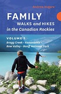
Family walks and hikes in the Canadian Rockies. Volume 1 : Bragg Creek - Kananaskis - Bow Valley - Banff National Park
https://archives.whyte.org/en/permalink/catalogue25204
- Medium
- Library - Book (including soft-cover and pamphlets)
- Published Date
- 2019
- Author
- Nugara, Andrew
- Publisher
- [Victoria, BC] : Rocky Mountain Books Ltd.
- Call Number
- 02.6 N89f Vol. 1
1 website
- Author
- Nugara, Andrew
- Responsibility
- Andrew Nugara
- Publisher
- [Victoria, BC] : Rocky Mountain Books Ltd.
- Published Date
- 2019
- Physical Description
- xx, 156 pages) : color illustrations, color maps
- Subjects
- Hiking
- Travel
- Banff National Park
- Kootenay National Park
- Highways
- Highways - Alberta
- Kananaskis Country
- Maps
- Lake Louise
- Lake Louise - Roads & Trails
- Abstract
- Family Walks and Hikes is an exciting new series of books written specifically for outdoor enthusiasts of all ages and abilities. These accurate, attractive guides feature expertly curated routes, informative maps, and colour photographs. The first book for the Canadian Rockies in the series brings together an inspiring collection of comfortable walks and spectacular hikes for visitors and locals looking for unique, guided wanderings in a number of diverse locations in the Rockies, including: Elbow Falls Powderface Ridge Troll Falls Elbow Lake Grotto Canyon Grassi Lakes Tunnel Mountain Johnston Canyon Stanley Glacier Plain Of Six Glaciers Bow Summit Ranging from charmingly easy to moderately challenging, these hikes are all accessible from reliable roads and popular staging areas. In addition, each hike is accompanied by a clear, colourful map, step by step directions, and full-colour photographs. Each route includes: detailed directions to trailheads colour maps and photographs seasonal information round-trip distances trail commentary difficulty ratings (from Rocky Mountain Books website)
- Contents
- Introduction
- Area Maps
- Highway 66, The Elbow
- Highway 40 South, Kananaskis Trail
- Highway 1, Bow Valley, Canmore, Highway 742 South
- Banff
- Kootenay National Park
- Lake Louise
- Icefield Parkway (Highway 93 North(
- Important Contacts
- Acknowledgements
- ISBN
- 9781771602242
- Accession Number
- P2020.07
- Call Number
- 02.6 N89f Vol. 1
- Collection
- Archives Library
- URL Notes
- Publishers website
Websites
This material is presented as originally created; it may contain outdated cultural descriptions and
potentially offensive content.
Read more.
Family walks and hikes in the Canadian Rockies. Volume 2 : Bragg Creek , Kananaskis , Moraine Lake , Yoho , Icefields Parkway , Jasper
https://archives.whyte.org/en/permalink/catalogue25205
- Medium
- Library - Book (including soft-cover and pamphlets)
- Published Date
- 2019
- Author
- Nugara, Andrew
- Publisher
- [Victoria, BC] : Rocky Mountain Books Ltd.
- Edition
- First
- Call Number
- 02.6 N89f Vol. 2
1 website
- Author
- Nugara, Andrew
- Responsibility
- Andrew Nugara
- Edition
- First
- Publisher
- [Victoria, BC] : Rocky Mountain Books Ltd.
- Published Date
- 2019
- Physical Description
- volumes : colour illustrations, colour maps ; 22 cm
- Subjects
- Hiking
- Travel
- Kananaskis Country
- Maps
- Highways
- Highways - Alberta
- Banff
- Moraine Lake
- Yoho National Park
- Jasper
- Abstract
- amily Walks and Hikes is an exciting series of books written specifically for outdoor enthusiasts of all ages and abilities. These accurate, attractive guides feature expertly curated routes, informative maps, and colour photographs. Andrew Nugara’s second book for families looking to experience the splendour of the Canadian Rockies describes additional trips in Bragg Creek, Banff, and Kananaskis that were not included in Volume 1 due to redevelopment of these hiking hotspots since the dramatic Alberta floods of 2013. As well, Volume 2 includes several new areas for family exploration, including Moraine Lake, Yoho, the north section of Highway 93 North, and Jasper. Some of the comfortable walks and spectacular hikes in this new volume are: Forgetmenot Ponds Nihahi Ridge King Creek Canyon Canadian Everest Trail Picklejar Lakes Yamnuska Ha Ling Peak Sunshine Meadows Paget Peak Lookout Takakkaw Falls Parker Ridge Athabasca Glacier Sunwapta Falls Maligne Canyon Ranging from charmingly easy to moderately challenging, all of these hikes are accessible from reliable roads and popular staging areas. In addition, each hike is accompanied by a clear, colourful map, step by step directions, and full-colour photographs. Each route includes: detailed directions to trailheads colour maps and photographs seasonal information round-trip distances trail commentary difficulty ratings (from Rocky Mountain Books website)
- Contents
- Introduction
- Area Maps
- Highway 66, the Elbow
- Highway 40 South, Kananaskis Trail
- Highway 1, Bow Valley, Canmore, Highway 742 South
- Banff Area
- Moraine Lake
- Yoho National Park
- Icefields Parkway (Highway 93 North)
- Jasper
- Important Contacts
- Acknowledgements
- Disclaimer
- ISBN
- 9781771603058
- Accession Number
- P2020.07
- Call Number
- 02.6 N89f Vol. 2
- Collection
- Archives Library
- URL Notes
- Publishers website
Websites
This material is presented as originally created; it may contain outdated cultural descriptions and
potentially offensive content.
Read more.

Walks and easy hikes in the Canadian Rockies
https://archives.whyte.org/en/permalink/catalogue14579
- Medium
- Library - Book (including soft-cover and pamphlets)
- Published Date
- 2012
- Author
- Pole, Graeme
- Publisher
- Hazelton, British Columbia : Mountain Vision Publishing
- Edition
- 20th anniversary edition
- Call Number
- 02.6 P75w 2012
- Author
- Pole, Graeme
- Edition
- 20th anniversary edition
- Publisher
- Hazelton, British Columbia : Mountain Vision Publishing
- Published Date
- 2012
- Physical Description
- 184 pages : illustrations, maps, portraits ; 23 cm
- Series
- A Canadian Rockies Companion Guide
- Subjects
- Banff National Park
- Hiking
- Jasper National Park
- Kananaskis Provincial Park
- Kootenay National Park
- Waterton Lakes National Park
- Notes
- "151 superb outings in the Rockies"--Cover.
- Includes bibliographical references and index.
- ISBN
- 9780969724957
- Accession Number
- 2015.8526
- Call Number
- 02.6 P75w 2012
- Collection
- Archives Library
This material is presented as originally created; it may contain outdated cultural descriptions and
potentially offensive content.
Read more.

Mount Pocaterra Highwood Pass
https://archives.whyte.org/en/permalink/descriptions57772
- Part Of
- Alpine Club of Canada fonds
- Scope & Content
- File consists of a summit record from Mount Pocaterra produced by the Alpine Club of Canada in 2006. Summit record includes entries from visitors to the various summits which pertain to individuals' hiking and climbing trips; details of specific events which occurred while at the summit, wildlife s…
- Date Range
- 2006
- Reference Code
- M200 / V / A / 186
- Description Level
- 5 / File
- GMD
- Textual record
- Organization record
- Part Of
- Alpine Club of Canada fonds
- Description Level
- 5 / File
- Fonds Number
- M200
- V14
- S6
- Series
- M200 / V: Summit Records
- Sous-Fonds
- M200
- Sub-Series
- M200 / V / A: Identified Summit Records
- Accession Number
- accn. 2023.19
- Reference Code
- M200 / V / A / 186
- Responsibility
- Summit Registers and Notes produced by Alpine Club of Canada
- Date Range
- 2006
- Physical Description
- 0.5 cm of textual record 1 volume
- History / Biographical
- Mount Pocaterra is located in the Elk Range of the Canadian Rockies, Alberta. Mount Pocaterra is in Kananaskis.
- Scope & Content
- File consists of a summit record from Mount Pocaterra produced by the Alpine Club of Canada in 2006. Summit record includes entries from visitors to the various summits which pertain to individuals' hiking and climbing trips; details of specific events which occurred while at the summit, wildlife sightings, trail updates, and related topics. File: M200 / V / A / 186: Mount Pocaterra Highwood Pass
- Name Access
- Alpine Club of Canada
- Subject Access
- Alberta
- Alpine Club of Canada
- Backpacking
- Bow Valley
- Climbing
- Club
- Description and travel
- Environment
- Environment and Nature
- Hiking
- Kananaskis Country
- Mountain
- Mountaineering
- Mountaineers
- Mountains
- Record keeping
- Sports and leisure
- Sports and recreation
- Summit
- Trails
- Geographic Access
- Canada
- Canadian Rocky Mountains
- Rocky Mountains
- Elk Range
- Alberta
- Kananaskis
- Kananaskis Country
- Peter Lougheed Provincial Park
- Lower Kananaskis Lake
- Mount Pocaterra
- Access Restrictions
- Restrictions may apply
- Language
- English
- Related Material
- M235
- Title Source
- Original title
- Processing Status
- Processed
This material is presented as originally created; it may contain outdated cultural descriptions and
potentially offensive content.
Read more.
The Pass in the Clouds
https://archives.whyte.org/en/permalink/catalogue10965
- Medium
- Library - Book (including soft-cover and pamphlets)
- Published Date
- [196-?]
- Author
- Anonymous
- Call Number
- 02.6 Ab8 Pam
- Author
- Anonymous
- Published Date
- [196-?]
- Physical Description
- 8l
- Subjects
- Hiking
- Kananaskis
- Accession Number
- 3069
- Call Number
- 02.6 Ab8 Pam
- Collection
- Archives Library
This material is presented as originally created; it may contain outdated cultural descriptions and
potentially offensive content.
Read more.
Summit Records
https://archives.whyte.org/en/permalink/descriptions57660
- Part Of
- Alpine Club of Canada fonds
- Scope & Content
- Series of summit records from various summits produced by the Alpine Club of Canada between 1916 and 2020. Summit records include entries from visitors to the various summits which pertain to individuals' hiking and climbing trips; details of specific events which occurred while at the summit, wil…
- Date Range
- 1916
- 1930-1931
- 1959-1968
- 1970-1989
- 1992 -2020
- Reference Code
- M200 / V
- Description Level
- 3 / Series
- GMD
- Textual record
- Organization record
- Part Of
- Alpine Club of Canada fonds
- Description Level
- 3 / Series
- Fonds Number
- M200
- V14
- S6
- Series
- M200 / V: Summit Records
- Sous-Fonds
- M200
- Accession Number
- accn. 2023.20
- accn. 7779
- accn. 2023.10
- accn. 2014.8347
- accn. 6465
- accn. 8002
- accn. 2020.05
- accn. 2023.19
- accn. 2014.8293
- accn. 8119
- accn. 2023.32
- accn. 2023.41
- accn. 6623
- accn. 6062
- accn. 2014.8318
- accn. 6767
- accn. 2014.8315
- accn. 2014.8317
- accn. 5680
- accn. 2023.16
- accn. 2018.9010
- accn. 5396
- accn. 6459
- accn. 2014.8316
- accn. 2023.18
- accn. 5631
- accn. 2013.8245
- accn. 2014.8275
- accn. 2023.06
- accn. 2023.14
- accn. 2023.17
- accn. 5569
- accn. 8113
- accn. 6396
- Reference Code
- M200 / V
- Responsibility
- Registers produced by the Alpine Club of Canada
- Date Range
- 1916
- 1930-1931
- 1959-1968
- 1970-1989
- 1992 -2020
- Physical Description
- 110 cm of textual records ca. 235 volumes
- Scope & Content
- Series of summit records from various summits produced by the Alpine Club of Canada between 1916 and 2020. Summit records include entries from visitors to the various summits which pertain to individuals' hiking and climbing trips; details of specific events which occurred while at the summit, wildlife sightings, trail updates, and related topics.
- Notes
- See file-level entries for inventories of summit registers and notes.
- Name Access
- Alpine Club of Canada
- Subject Access
- Abbot Pass Hut
- Activities
- Alberta
- Alpine Club of Canada
- Backcountry skiing
- Backpacking
- Banff National Park
- Bow Valley
- British Columbia
- Castle Mountain
- Centennial
- Climbing
- Club
- Environment
- Environment and Nature
- Fay Hut
- Fortress Mountain
- Glaciers
- Hiking
- Ice climbing
- Kananaskis Country
- Mount Assiniboine
- Mountain
- Mountaineering
- Mountaineers
- Mountains
- National parks and reserves
- Parks Canada
- Porcupine
- Provincial parks and reserves
- Rundle Mountain
- Ski area
- Ski mountaineering
- Skiing
- Sports and recreation
- Summit
- Temple Mountain
- Trail making
- Trails
- Travel and Exploration
- Winter sports
- Yamnuska Mountain
- Geographic Access
- Canada
- Alberta
- British Columbia
- Abbot Pass
- Assiniboine
- Banff National Park
- Banff, Alberta
- Bugaboos
- Canadian Rocky Mountains
- Canmore
- Cascade Mountain
- Castle Mountain, AB
- Cathedral Mountain
- Glacier
- Jasper National Park
- Kananaskis Country
- Little Yoho Valley
- Mount Assiniboine
- Mount Baldy
- Mount Baker
- Mount Cory
- Mount Edith
- Mount Lefroy
- Mount Norquay
- Mount Rundle
- Mount Temple
- Mount Victoria
- Mount Yamnuska
- Rocky Mountains
- Rundle Mountain
- Selkirks
- Yoho National Park
- Access Restrictions
- Restrictions may apply
- Language
- English
- Conservation
- Some records have been placed in mylar. Some record have mold, rust or water damage.
- Related Material
- M235
- Title Source
- Title based on contents of series
- Processing Status
- Processed
This material is presented as originally created; it may contain outdated cultural descriptions and
potentially offensive content.
Read more.
East End of Rundle (EEOR) / Mount Rundle Summit Registers and Notes
https://archives.whyte.org/en/permalink/descriptions57665
- Part Of
- Alpine Club of Canada fonds
- Scope & Content
- Files consist of summit notes and summit registers from East End of Rundle and Mount Rundle produced by the Alpine Club of Canada between around 2001 to 2017. Summit records include entries from visitors to the various summits which pertain to individuals' hiking and climbing trips; details of spec…
- Date Range
- ca. 2001-2002
- 2014-2017
- Reference Code
- M200 / V / A / 26 to 29
- Description Level
- 5 / File
- GMD
- Textual record
- Organization record
- Part Of
- Alpine Club of Canada fonds
- Description Level
- 5 / File
- Fonds Number
- M200
- V14
- S6
- Series
- M200 / V: Summit Records
- Sous-Fonds
- M200
- Sub-Series
- M200 / V / A: Identified Summit Records
- Accession Number
- accn. 8119
- accn. 7779
- accn. 2023.20
- accn. 2023.32
- Reference Code
- M200 / V / A / 26 to 29
- Responsibility
- Summit Registers and Notes produced by Alpine Club of Canada
- Date Range
- ca. 2001-2002
- 2014-2017
- Physical Description
- 4 volumes 7 cm of textual records
- History / Biographical
- The East End of Rundle is part of the eastern ridge of Mount Rundle near Canmore, AB. From the summit, views of Ha Ling Peak and Spray Valley can be seen.
- Scope & Content
- Files consist of summit notes and summit registers from East End of Rundle and Mount Rundle produced by the Alpine Club of Canada between around 2001 to 2017. Summit records include entries from visitors to the various summits which pertain to individuals' hiking and climbing trips; details of specific events which occurred while at the summit, wildlife sightings, trail updates, and related topics. Files include: M200 / V / A / 26: Mt. Rundle Register [ca. 2001] M200 / V / A / 27: Mount Rundle East June 2002 - Sep 2002 M200 / V / A / 28: EEOR Summit Register [ca. 2014 - 2015] M200 / V / A / 29: East End of Rundle Summit Log [2016-2017]
- Name Access
- Alpine Club of Canada
- Subject Access
- Alpine Club of Canada
- Backcountry skiing
- Backpacking
- Banff
- Bow Valley
- Climbing
- Club
- Environment and Nature
- Environment
- Hiking
- Kananaskis Country
- Mountain
- Mountaineering
- Mountaineers
- Mountains
- Provincial parks and reserves
- Rundle Mountain
- Sports and leisure
- Sports and recreation
- Summit
- Trails
- Winter sports
- Geographic Access
- Canada
- Alberta
- Bow Valley
- Canmore
- Banff
- Banff National Park
- Grassi Lake
- Kananaskis Country
- Mount Rundle
- Rocky Mountains
- Rundle Mountain
- Spray Lakes
- Access Restrictions
- Restrictions may apply
- Language
- English
- French
- Mandarin
- Japanese
- Spanish
- Conservation
- Some registers have water damage and rust damage.
- Related Material
- M235
- Biographical Source Notes
- All Trails East End of Rundle (EEOR) https://www.alltrails.com/trail/canada/alberta/east-end-of-rundle-eeor
- Title Source
- Title based on contents of file
- Processing Status
- Processed
This material is presented as originally created; it may contain outdated cultural descriptions and
potentially offensive content.
Read more.
Wasootch Summit Registers and Notes
https://archives.whyte.org/en/permalink/descriptions57666
- Part Of
- Alpine Club of Canada fonds
- Scope & Content
- Files consist of summit notes and summit registers from Wasootch Peak produced by the Alpine Club of Canada between around 1994 to 2020. Summit records include entries from visitors to the various summits which pertain to individuals' hiking and climbing trips; details of specific events which occu…
- Date Range
- 2007-2008
- 2010-2020
- Reference Code
- M200 / V / A / 30 to 33
- Description Level
- 5 / File
- GMD
- Textual record
- Organization record
- Part Of
- Alpine Club of Canada fonds
- Description Level
- 5 / File
- Fonds Number
- M200
- V14
- S6
- Series
- M200 / V: Summit Records
- Sous-Fonds
- M200
- Sub-Series
- M200 / V / A: Identified Summit Records
- Accession Number
- accn. 2014.8347
- accn. 8002
- accn. 2023.20
- accn. 2023.41
- Reference Code
- M200 / V / A / 30 to 33
- Responsibility
- Summit Registers and Notes produced by Alpine Club of Canada
- Date Range
- 2007-2008
- 2010-2020
- Physical Description
- 4 volumes 7 cm of textual records
- History / Biographical
- Wasootch Peak is located in the Kananaskis Valley, near Mts. Kidd, Boggart, The Wedge, and Allan.
- Scope & Content
- Files consist of summit notes and summit registers from Wasootch Peak produced by the Alpine Club of Canada between around 1994 to 2020. Summit records include entries from visitors to the various summits which pertain to individuals' hiking and climbing trips; details of specific events which occurred while at the summit, wildlife sightings, trail updates, and related topics. Files include: M200 / V / A / 30: Wasootch Peak register M200 / V / A / 31: Summit Register - Wasootch Peak, May 2007 - Sep 2008 M200 / V / A / 32: Wasootch Peak [2013 - 2016] M200 / V / A / 33: [Wasootch Ridge, 2010 - 2020]
- Name Access
- Alpine Club of Canada
- Subject Access
- Alpine Club of Canada
- Backpacking
- Backcountry skiing
- Climbing
- Environment
- Environment and Nature
- Hiking
- Kananaskis Country
- Mount Allan
- Mountain
- Mountaineering
- Mountaineers
- Mountains
- Ski mountaineering
- Skiing
- Sports and leisure
- Sports and recreation
- Summit
- Trails
- Winter sports
- Geographic Access
- Canada
- Alberta
- Kananaskis Country
- Lac des Arcs
- Mount Kidd
- Access Restrictions
- Restrictions may apply
- Language
- English
- Conservation
- Some registers have been placed in mylar. Some registers have water damage and rust damage.
- Related Material
- M235
- Biographical Source Notes
- Summit Post.org Wasootch Peak https://www.summitpost.org/wasootch-peak/350954
- Title Source
- Title based on contents of file
- Processing Status
- Processed
This material is presented as originally created; it may contain outdated cultural descriptions and
potentially offensive content.
Read more.
MT. Yamnuska Summit Register
https://archives.whyte.org/en/permalink/descriptions57684
- Part Of
- Alpine Club of Canada fonds
- Scope & Content
- Files consist of one summit record from Mt. Yamnuska (Mount John Laurie) produced by the Alpine Club of Canada between August and September 2004. Summit record includes entries from visitors to the various summits which pertain to individuals' hiking and climbing trips; details of specific events w…
- Date Range
- August 2004 - September 2004
- Reference Code
- M200 / V / A / 74
- Description Level
- 5 / File
- GMD
- Textual record
- Organization record
- Part Of
- Alpine Club of Canada fonds
- Description Level
- 5 / File
- Fonds Number
- M200
- V14
- S6
- Series
- M200 / V: Summit Records
- Sous-Fonds
- M200
- Sub-Series
- M200 / V / A: Identified Summit Records
- Accession Number
- accn. 8002
- Reference Code
- M200 / V / A / 74
- Responsibility
- Summit Registers and Notes produced by Alpine Club of Canada
- Date Range
- August 2004 - September 2004
- Physical Description
- 0.5 cm of textual record 1 volume
- History / Biographical
- Mt. Yamnuska is a mountain in Alberta's Municipal District of Bighorn No. 8. Mt. Yamnuska (Mount John Laurie) is located in the Canadian Rockies, and was officially named Mount John Laurie in 1961. Nearby are Goat Mountain, Mount Lougheed, Mount Allen, Mount McGillivray and Skogan Peak.
- Scope & Content
- Files consist of one summit record from Mt. Yamnuska (Mount John Laurie) produced by the Alpine Club of Canada between August and September 2004. Summit record includes entries from visitors to the various summits which pertain to individuals' hiking and climbing trips; details of specific events which occurred while at the summit, wildlife sightings, trail updates, and related topics. File: M200 / V / A / 74: Summit Register - MT. Yamnuska, Aug 2004 - Sept 2004
- Name Access
- Alpine Club of Canada
- Subject Access
- Alberta
- Alpine Club of Canada
- Backpacking
- Climbing
- Environment
- Environment and Nature
- Hiking
- Kananaskis Country
- Mountain
- Mountaineering
- Mountaineers
- Mountains
- Record keeping
- Sports and leisure
- Sports and recreation
- Summit
- Trails
- Yamnuska Mountain
- Geographic Access
- Canada
- Alberta
- Canadian Rocky Mountains
- Rocky Mountains
- Bow Valley
- Canmore, AB
- Canmore, Alberta
- Canmore
- Kananaskis Country
- Mount Yamnuska
- Mount John Laurie
- Access Restrictions
- Restrictions may apply
- Language
- English
- Related Material
- M235
- Biographical Source Notes
- Mount Yamnuska Hike - Kananaskis Country, November 30, 2023, Travel Banff Canada: https://www.travelbanffcanada.com/mount-yamnuska-hike-kananaskis/
- Title Source
- Title based on contents of file
- Processing Status
- Processed
This material is presented as originally created; it may contain outdated cultural descriptions and
potentially offensive content.
Read more.
Mt. Bogart Summit Records
https://archives.whyte.org/en/permalink/descriptions57685
- Part Of
- Alpine Club of Canada fonds
- Scope & Content
- Files consist of summit notes and summit registers from Mount Bogart produced by the Alpine Club of Canada between 1972 and 1999. Summit records include entries from visitors to the various summits which pertain to individuals' hiking and climbing trips; details of specific events which occurred wh…
- Date Range
- 1972-1999
- Reference Code
- M200 / V / A / 75 to 76
- Description Level
- 5 / File
- GMD
- Textual record
- Organization record
- Part Of
- Alpine Club of Canada fonds
- Description Level
- 5 / File
- Fonds Number
- M200
- V14
- S6
- Series
- M200 / V: Summit Records
- Sous-Fonds
- M200
- Sub-Series
- M200 / V / A: Identified Summit Records
- Accession Number
- accn. 6767
- accn. 7779
- Reference Code
- M200 / V / A / 75 to 76
- Responsibility
- Summit Registers and Notes produced by Alpine Club of Canada
- Date Range
- 1972-1999
- Physical Description
- 2 volumes 2 cm of textual records
- History / Biographical
- Mt. Bogart is located in Kananaskis Country in the Canadian Rockies. Nearby are Mt. Kidd, Wind Mountain, and Mount Sparrowhawk.
- Scope & Content
- Files consist of summit notes and summit registers from Mount Bogart produced by the Alpine Club of Canada between 1972 and 1999. Summit records include entries from visitors to the various summits which pertain to individuals' hiking and climbing trips; details of specific events which occurred while at the summit, wildlife sightings, trail updates, and related topics. Files include: M200 / V / A / 75: [Mt. Bogart 1972 - 1994] M200 / V / A / 76: Mt. Bogart August 23, 1994 - Sept 4, 1999 Summit Register
- Name Access
- Alpine Club of Canada
- Subject Access
- Alberta
- Alpine Club of Canada
- Backpacking
- Backcountry skiing
- Climbing
- Description and travel
- Environment
- Environment and Nature
- Hiking
- Kananaskis Country
- Mountain
- Mountaineering
- Mountaineers
- Mountains
- Record keeping
- Sports and leisure
- Sports and recreation
- Summit
- Trails
- Geographic Access
- Canada
- Alberta
- Canadian Rocky Mountains
- Rocky Mountains
- Kananaskis
- Kananaskis Country
- Mount Kidd
- Mount Sparrowhawk
- Mount Bogart
- Access Restrictions
- Restrictions may apply
- Language
- English
- French
- Spanish
- Conservation
- Some registers placed in mylar. Some registers have rust damage or water damage.
- Related Material
- M235
- Biographical Source Notes
- Mount Bogart, Peak Finder: https://cdnrockiesdatabases.ca/peaks/148
- Title Source
- Title based on contents of file
- Processing Status
- Processed
This material is presented as originally created; it may contain outdated cultural descriptions and
potentially offensive content.
Read more.