Narrow Results By
Canadian Rockies
https://archives.whyte.org/en/permalink/descriptions54817
- Part Of
- Murray Hay fonds
- Scope & Content
- File consists of 1 cm of textual records, 10 x 22 cm. File pertains to tourist maps of the Canadian Rocky Mountains created by Murray Hay. File includes a brochure of titled "Canadian Rockies Access Maps" that, when unfolded, includes several maps of the various areas that make up the Canadian Rock…
- Date Range
- ca. 1990 - 1999
- 1999
- Reference Code
- M570 / III / D / i / 2
- Description Level
- 5 / File
- GMD
- Published record
- Map
- Textual record
- Part Of
- Murray Hay fonds
- Description Level
- 5 / File
- Fonds Number
- M570 / V795
- Series
- M570 / III : Murray Hay portfolio (published material)
- Sous-Fonds
- M570
- Sub-Series
- M570 / III / D : Miscellaneous / i : Canada (general)
- Accession Number
- 2019.41
- Reference Code
- M570 / III / D / i / 2
- Date Range
- ca. 1990 - 1999
- 1999
- Physical Description
- 1 cm of textual records (10 x 22 cm)
- Scope & Content
- File consists of 1 cm of textual records, 10 x 22 cm. File pertains to tourist maps of the Canadian Rocky Mountains created by Murray Hay. File includes a brochure of titled "Canadian Rockies Access Maps" that, when unfolded, includes several maps of the various areas that make up the Canadian Rocky Mountains, like Kananaskis Country, Canmore, Banff National Park, Jasper National Park, Yoho National Park, etc.
- Name Access
- Hay, Murray
- Subject Access
- Advertising
- Artist
- Banff
- Banff National Park
- Cartography
- Communications
- Lake Louise
- Kananaskis Country
- Map
- Mountains
- Tourism
- Tourist information
- Travel
- Geographic Access
- Canada
- Canadian Rocky Mountains
- Alberta
- British Columbia
- Yoho National Park
- Jasper National Park
- Banff National Park
- Glacier National Park
- Canmore
- Banff
- Jasper
- Lake Louise
- Kananaskis
- Kananaskis Country
- Kootenay National Park
- Language
- English
- Title Source
- Title based on contents of file
- Processing Status
- Processed
This material is presented as originally created; it may contain outdated cultural descriptions and
potentially offensive content.
Read more.
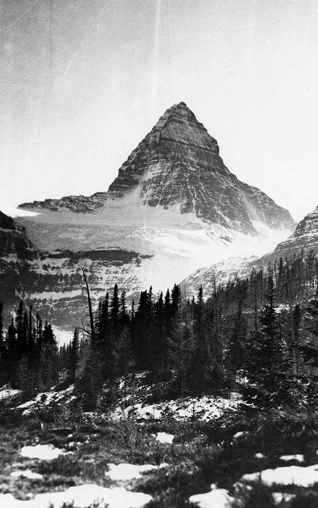
Canadian Rockies Photograph Album
https://archives.whyte.org/en/permalink/descriptions3599
- Part Of
- Lawrence Grassi fonds
- Scope & Content
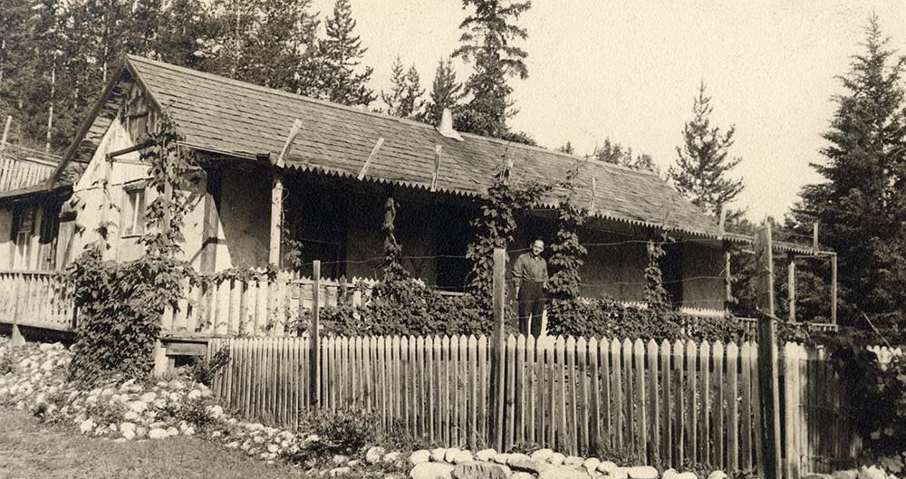
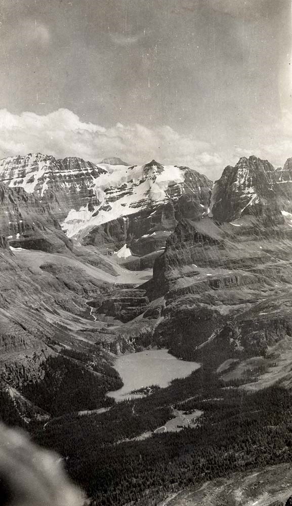
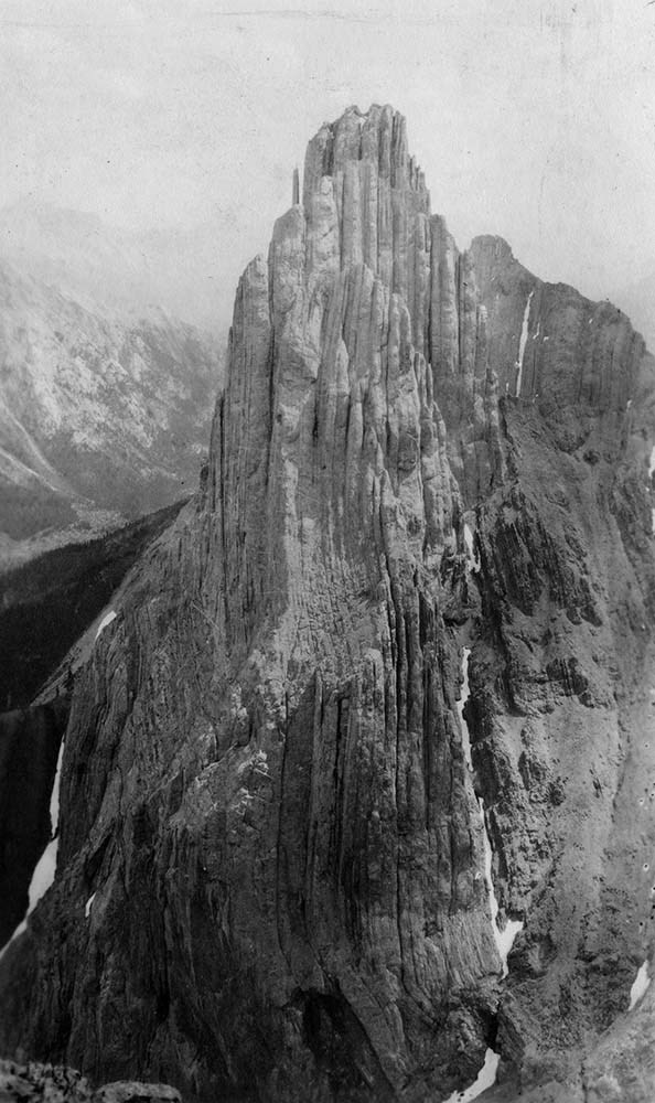
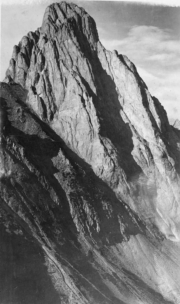
- File pertains to a photo album that Includes an assortment of views of the Canadian Rockies; mainly duplicates of those images in Series I. Landscape Photographs. Item-level inventory available.
- Date Range
- [ca. 1930-1970]
- Reference Code
- V240 / II / A / PD - 624
- Description Level
- 5 / File
- GMD
- Album
- Photograph
6 images
- Part Of
- Lawrence Grassi fonds
- Description Level
- 5 / File
- Fonds Number
- M45 / V240
- Series
- II.A. Landscape photographs
- Sous-Fonds
- V240
- Accession Number
- 3159
- Reference Code
- V240 / II / A / PD - 624
- GMD
- Album
- Photograph
- Date Range
- [ca. 1930-1970]
- Physical Description
- 1 photograph album (180 prints)
- History / Biographical
- See fonds level description
- Scope & Content
- File pertains to a photo album that Includes an assortment of views of the Canadian Rockies; mainly duplicates of those images in Series I. Landscape Photographs. Item-level inventory available.
- Name Access
- Grassi, Lawrence
- Subject Access
- Activities
- Alpine Club of Canada
- Animals
- Cabins and shelters
- Camps
- Environment and Nature
- Exploration
- Family and personal life
- Grassi Lakes
- Home
- Kananaskis Country
- Lake O'Hara region
- Mountains
- Parks
- Provincial parks and reserves
- Scenery
- Trails
- Trail making
- Travel
- Geographic Access
- Canmore
- Lake Louise
- Lake O'Hara
- Banff
- Banff National Park
- Yoho National Park
- Kananaskis
- Alberta
- British Columbia
- Canada
- Language
- English
- Title Source
- Title based on contents of file
- Processing Status
- Processed
Images

This material is presented as originally created; it may contain outdated cultural descriptions and
potentially offensive content.
Read more.
East End of Rundle (EEOR) / Mount Rundle Summit Registers and Notes
https://archives.whyte.org/en/permalink/descriptions57665
- Part Of
- Alpine Club of Canada fonds
- Scope & Content
- Files consist of summit notes and summit registers from East End of Rundle and Mount Rundle produced by the Alpine Club of Canada between around 2001 to 2017. Summit records include entries from visitors to the various summits which pertain to individuals' hiking and climbing trips; details of spec…
- Date Range
- ca. 2001-2002
- 2014-2017
- Reference Code
- M200 / V / A / 26 to 29
- Description Level
- 5 / File
- GMD
- Textual record
- Organization record
- Part Of
- Alpine Club of Canada fonds
- Description Level
- 5 / File
- Fonds Number
- M200
- V14
- S6
- Series
- M200 / V: Summit Records
- Sous-Fonds
- M200
- Sub-Series
- M200 / V / A: Identified Summit Records
- Accession Number
- accn. 8119
- accn. 7779
- accn. 2023.20
- accn. 2023.32
- Reference Code
- M200 / V / A / 26 to 29
- Responsibility
- Summit Registers and Notes produced by Alpine Club of Canada
- Date Range
- ca. 2001-2002
- 2014-2017
- Physical Description
- 4 volumes 7 cm of textual records
- History / Biographical
- The East End of Rundle is part of the eastern ridge of Mount Rundle near Canmore, AB. From the summit, views of Ha Ling Peak and Spray Valley can be seen.
- Scope & Content
- Files consist of summit notes and summit registers from East End of Rundle and Mount Rundle produced by the Alpine Club of Canada between around 2001 to 2017. Summit records include entries from visitors to the various summits which pertain to individuals' hiking and climbing trips; details of specific events which occurred while at the summit, wildlife sightings, trail updates, and related topics. Files include: M200 / V / A / 26: Mt. Rundle Register [ca. 2001] M200 / V / A / 27: Mount Rundle East June 2002 - Sep 2002 M200 / V / A / 28: EEOR Summit Register [ca. 2014 - 2015] M200 / V / A / 29: East End of Rundle Summit Log [2016-2017]
- Name Access
- Alpine Club of Canada
- Subject Access
- Alpine Club of Canada
- Backcountry skiing
- Backpacking
- Banff
- Bow Valley
- Climbing
- Club
- Environment and Nature
- Environment
- Hiking
- Kananaskis Country
- Mountain
- Mountaineering
- Mountaineers
- Mountains
- Provincial parks and reserves
- Rundle Mountain
- Sports and leisure
- Sports and recreation
- Summit
- Trails
- Winter sports
- Geographic Access
- Canada
- Alberta
- Bow Valley
- Canmore
- Banff
- Banff National Park
- Grassi Lake
- Kananaskis Country
- Mount Rundle
- Rocky Mountains
- Rundle Mountain
- Spray Lakes
- Access Restrictions
- Restrictions may apply
- Language
- English
- French
- Mandarin
- Japanese
- Spanish
- Conservation
- Some registers have water damage and rust damage.
- Related Material
- M235
- Biographical Source Notes
- All Trails East End of Rundle (EEOR) https://www.alltrails.com/trail/canada/alberta/east-end-of-rundle-eeor
- Title Source
- Title based on contents of file
- Processing Status
- Processed
This material is presented as originally created; it may contain outdated cultural descriptions and
potentially offensive content.
Read more.
Mt. Westwind Peak Sept. 2016
https://archives.whyte.org/en/permalink/descriptions57762
- Part Of
- Alpine Club of Canada fonds
- Scope & Content
- File consists of a summit record from West Wind Peak produced by the Alpine Club of Canada between 2005 and 2016. Summit record includes entries from visitors to the various summits which pertain to individuals' hiking and climbing trips; details of specific events which occurred while at the summi…
- Date Range
- 2005-2016
- Reference Code
- M200 / V / A / 175
- Description Level
- 5 / File
- GMD
- Textual record
- Organization record
- Part Of
- Alpine Club of Canada fonds
- Description Level
- 5 / File
- Fonds Number
- M200
- V14
- S6
- Series
- M200 / V: Summit Records
- Sous-Fonds
- M200
- Sub-Series
- M200 / V / A: Identified Summit Records
- Accession Number
- accn. 2023.20
- Reference Code
- M200 / V / A / 175
- Responsibility
- Summit Registers and Notes produced by Alpine Club of Canada
- Date Range
- 2005-2016
- Physical Description
- 2 cm of textual record 1 volume
- History / Biographical
- West Wind Peak is located in Kananaskis, Alberta.
- Scope & Content
- File consists of a summit record from West Wind Peak produced by the Alpine Club of Canada between 2005 and 2016. Summit record includes entries from visitors to the various summits which pertain to individuals' hiking and climbing trips; details of specific events which occurred while at the summit, wildlife sightings, trail updates, and related topics. File: M200 / V / A / 175: Mt. Westwind Peak Sept. 2016
- Name Access
- Alpine Club of Canada
- Subject Access
- Alberta
- Alpine Club of Canada
- Backpacking
- Banff
- Bow Valley
- Climbing
- Club
- Description and travel
- Environment
- Environment and Nature
- Hiking
- Kananaskis Country
- Mountain
- Mountaineering
- Mountaineers
- Mountains
- Record keeping
- Sports and leisure
- Sports and recreation
- Summit
- Trails
- Geographic Access
- Canada
- Canadian Rocky Mountains
- Rocky Mountains
- Alberta
- Kananaskis
- Kananaskis Country
- Kananaskis, AB
- Banff
- Canmore
- Canmore, AB
- Windtower
- Three Sisters
- Westwind Peak
- West Wind Peak
- Access Restrictions
- Restrictions may apply
- Language
- English
- Related Material
- M235
- Title Source
- Original title
- Processing Status
- Processed
This material is presented as originally created; it may contain outdated cultural descriptions and
potentially offensive content.
Read more.