Narrow Results By
1973 Scrap Book [#2]
https://archives.whyte.org/en/permalink/descriptions54869
- Scope & Content
- File consists of a scrapbook containing newspaper clippings and photocopied clippings pertaining mostly to skiing, skiers, ski hills, heli skiing, and generally winter sports throughout Western Canada, with particular focus on Banff National Park. Includes clippings about the Chateau Lake Louise st…
- Date Range
- ca. 1973
- Reference Code
- M132 / 185
- Description Level
- 5 / File
- GMD
- Scrapbook
1 image
1 Electronic Resource
- Description Level
- 5 / File
- Fonds Number
- M132 / V43
- Sous-Fonds
- M132
- Sub-Series
- III / B Other records
- Accession Number
- 6060
- Reference Code
- M132 / 185
- GMD
- Scrapbook
- Date Range
- ca. 1973
- Physical Description
- 2.5 cm of textual records (38 pages ; 27.5 x 38.5 cm)
- History / Biographical
- See fonds level description.
- Scope & Content
- File consists of a scrapbook containing newspaper clippings and photocopied clippings pertaining mostly to skiing, skiers, ski hills, heli skiing, and generally winter sports throughout Western Canada, with particular focus on Banff National Park. Includes clippings about the Chateau Lake Louise staying open year-round.
- Subject Access
- Alberta Winter Games
- Awards
- Banff Winter Festival
- Chateau Lake Louise
- Buildings and facilities
- Businesses
- Community events
- Heli skiing
- Industry
- National parks and reserves
- Newspaper
- Park policy
- Ski areas
- Ski jumping
- Ski lodges and cabins
- Ski racing
- Skiers
- Skiing
- Tourism
- Geographic Access
- Banff
- Lake Louise
- Banff National Park
- Jasper
- Jasper National Park
- Red Deer
- Alberta
- Canada
- Language
- English
- French
- Conservation
- Blank pages not scanned
- Title Source
- Title written on the cover
- Processing Status
- Processed
Electronic Resources
Images

This material is presented as originally created; it may contain outdated cultural descriptions and
potentially offensive content.
Read more.
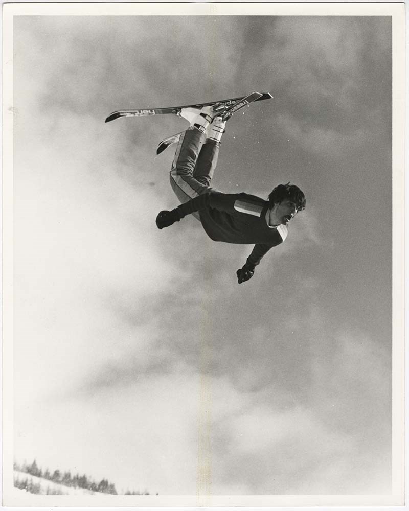
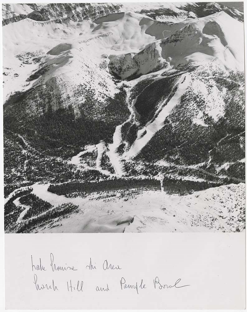
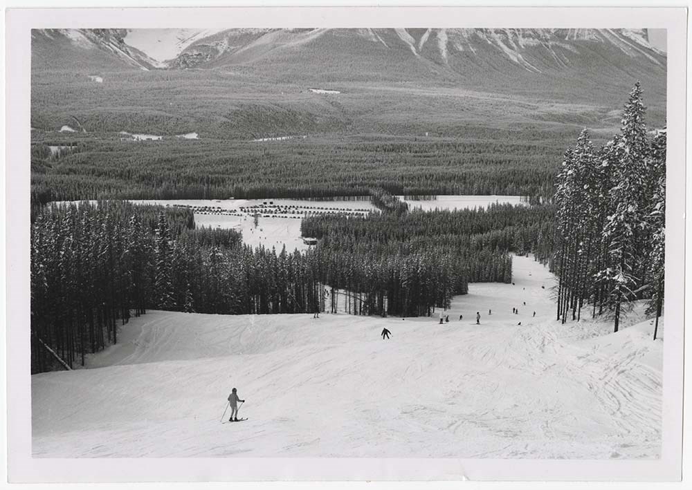
Action on Skis
https://archives.whyte.org/en/permalink/descriptions56697
- Part Of
- Bruno Engler fonds
- Scope & Content
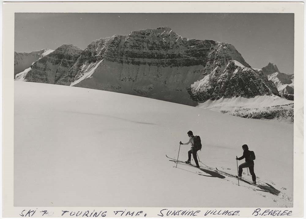
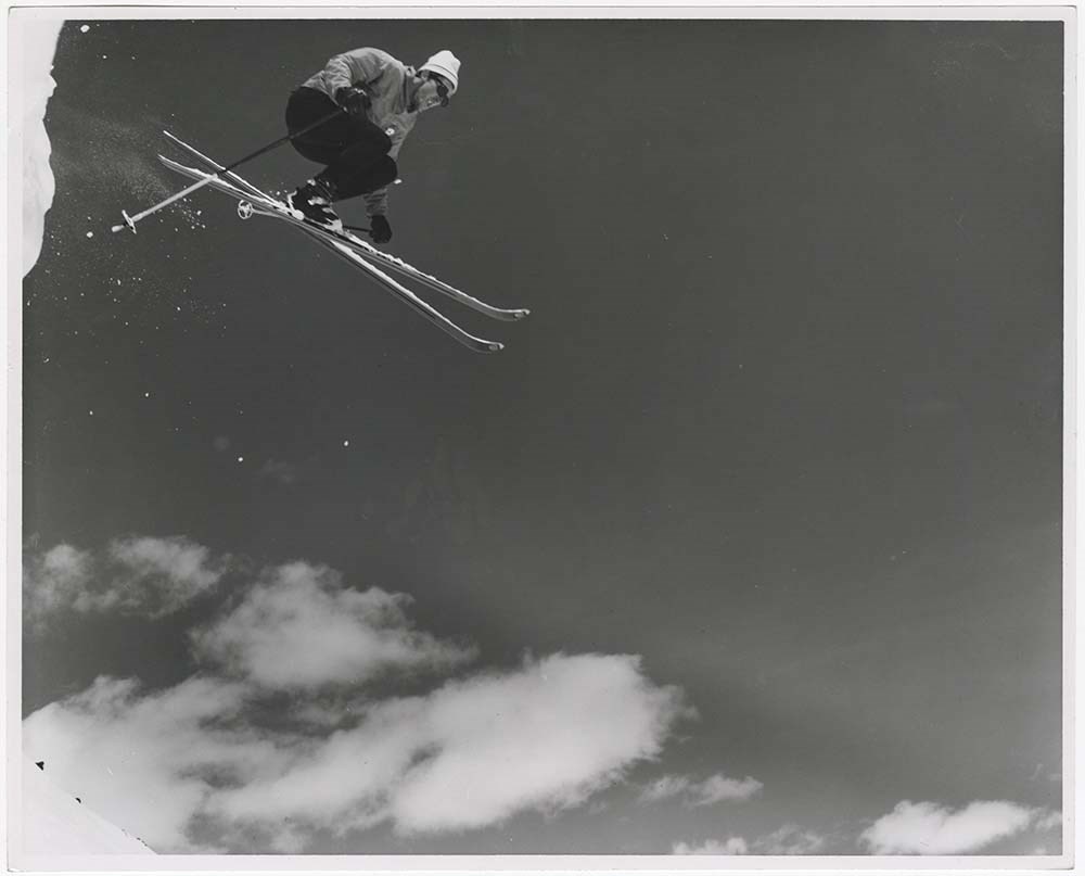
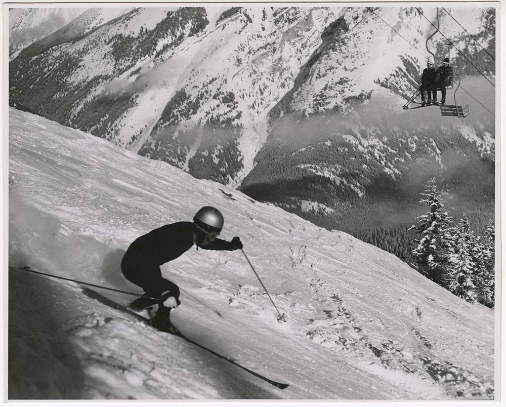
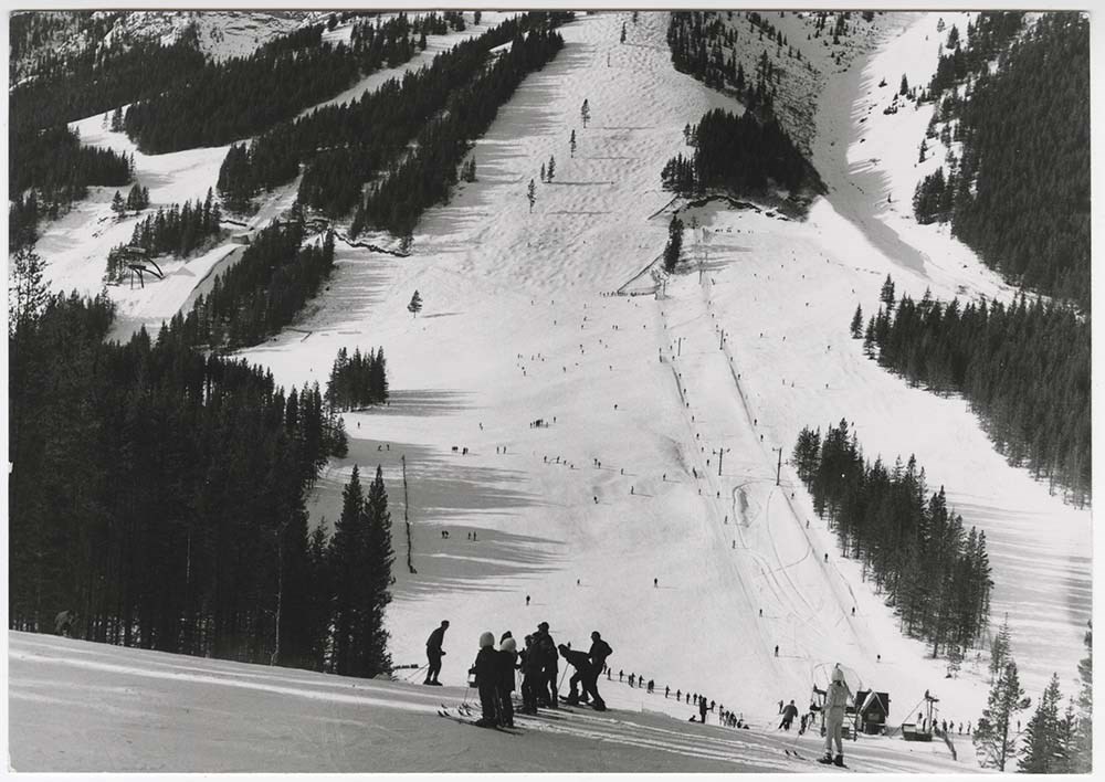
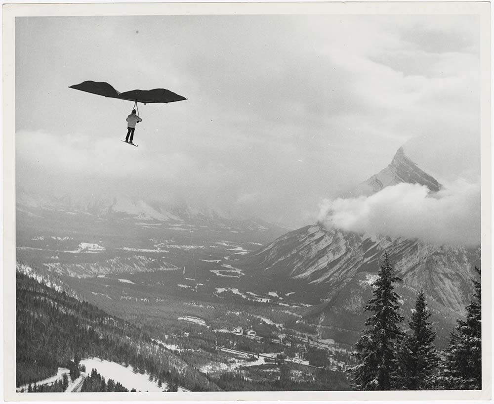
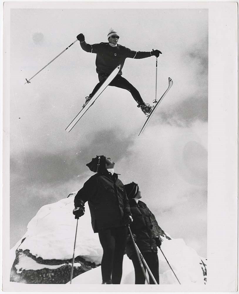
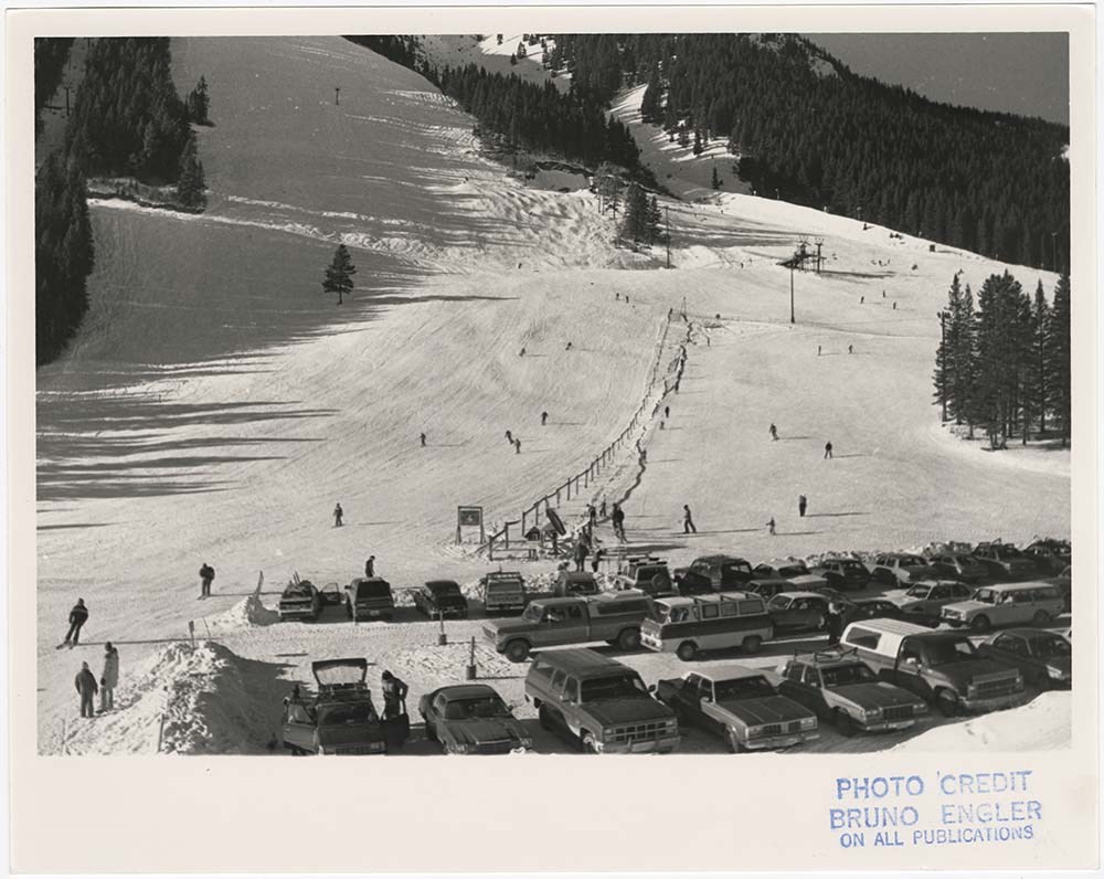
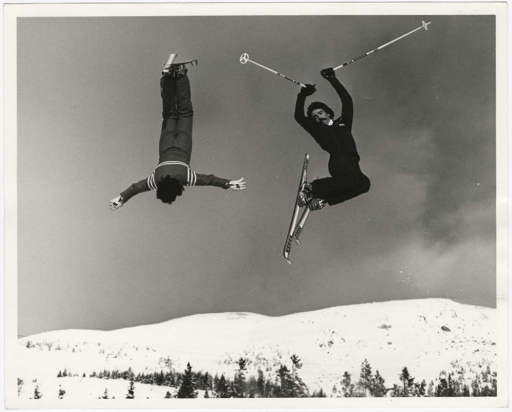
- File pertains to 38 b&w prints of people skiing. Includes action shots of people skiing at Norquay, Lake Louise, and Sunshine, the Norquay parking lot, ski jumping, ski racing, and an unidentified person paragliding on skis at Norquay.
- Date Range
- [ca. 1948-1980]
- Reference Code
- V190 / VI / A / ii / PA - 01 to PA - 38
- Description Level
- 5 / File
- GMD
- Photograph print
12 images
- Part Of
- Bruno Engler fonds
- Description Level
- 5 / File
- Fonds Number
- M323 / S40 / V190
- Series
- VI : Retained file, A : Alphabetical order
- Sous-Fonds
- V190
- Sub-Series
- ii : Action on Skis
- Accession Number
- 7436
- Reference Code
- V190 / VI / A / ii / PA - 01 to PA - 38
- Date Range
- [ca. 1948-1980]
- Physical Description
- 38 photographs : b&w ; 25.5 x 20.5 cm or smaller
- History / Biographical
- See fonds level description
- Scope & Content
- File pertains to 38 b&w prints of people skiing. Includes action shots of people skiing at Norquay, Lake Louise, and Sunshine, the Norquay parking lot, ski jumping, ski racing, and an unidentified person paragliding on skis at Norquay.
- Name Access
- Engler, Bruno
- Subject Access
- Activities
- Lake Louise Ski Area
- Mountains
- Norquay Ski Hill
- Ski areas
- Ski jumping
- Ski racing
- Skiing
- Sports and leisure
- Sunshine Ski Resort
- Winter
- Winter sports
- Geographic Access
- Banff
- Lake Louise
- Banff National Park
- Alberta
- Language
- English
- Creator
- Engler, Bruno
- Title Source
- Original title kept
- Processing Status
- Processed
Images
This material is presented as originally created; it may contain outdated cultural descriptions and
potentially offensive content.
Read more.
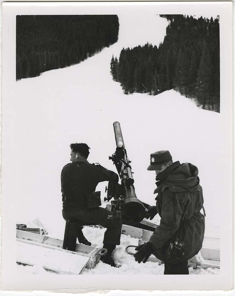
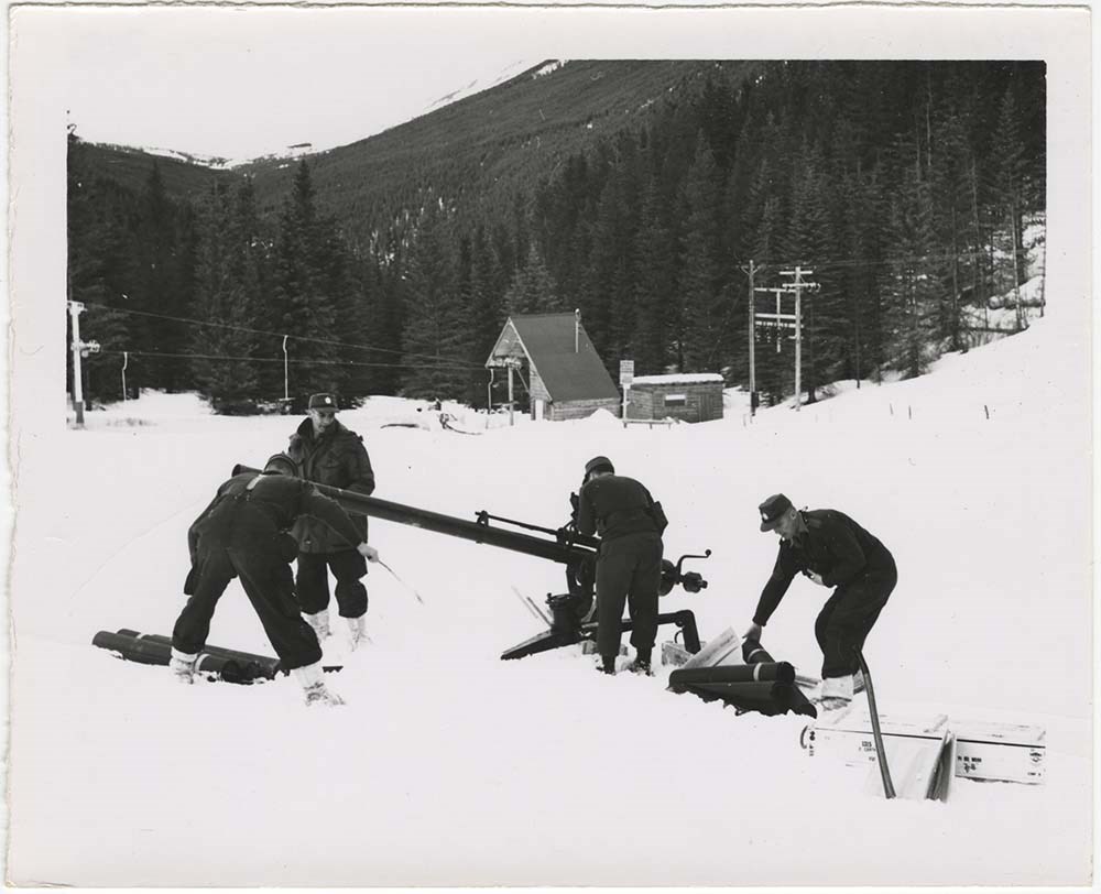
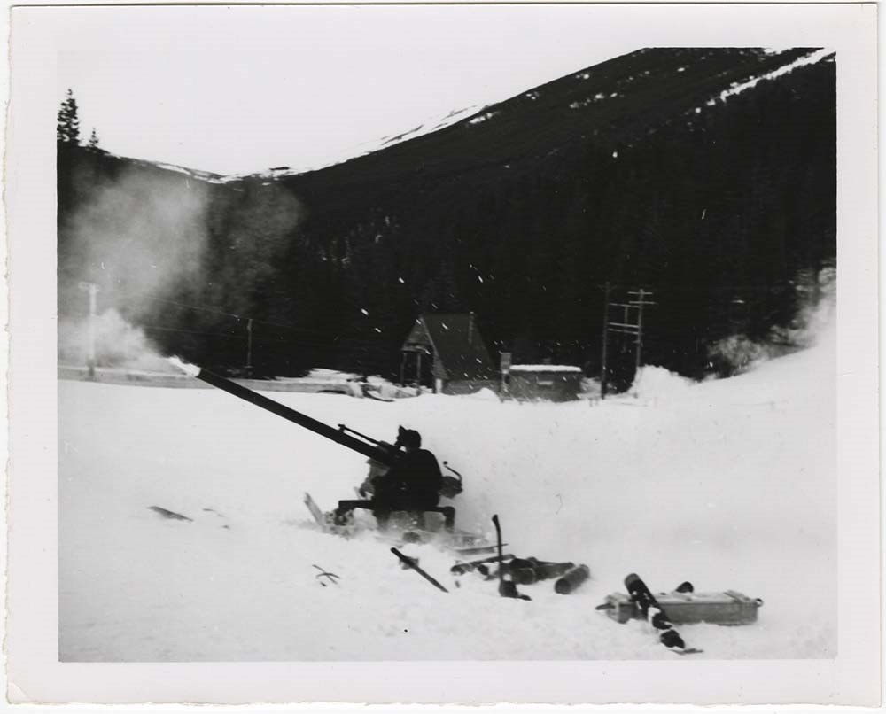
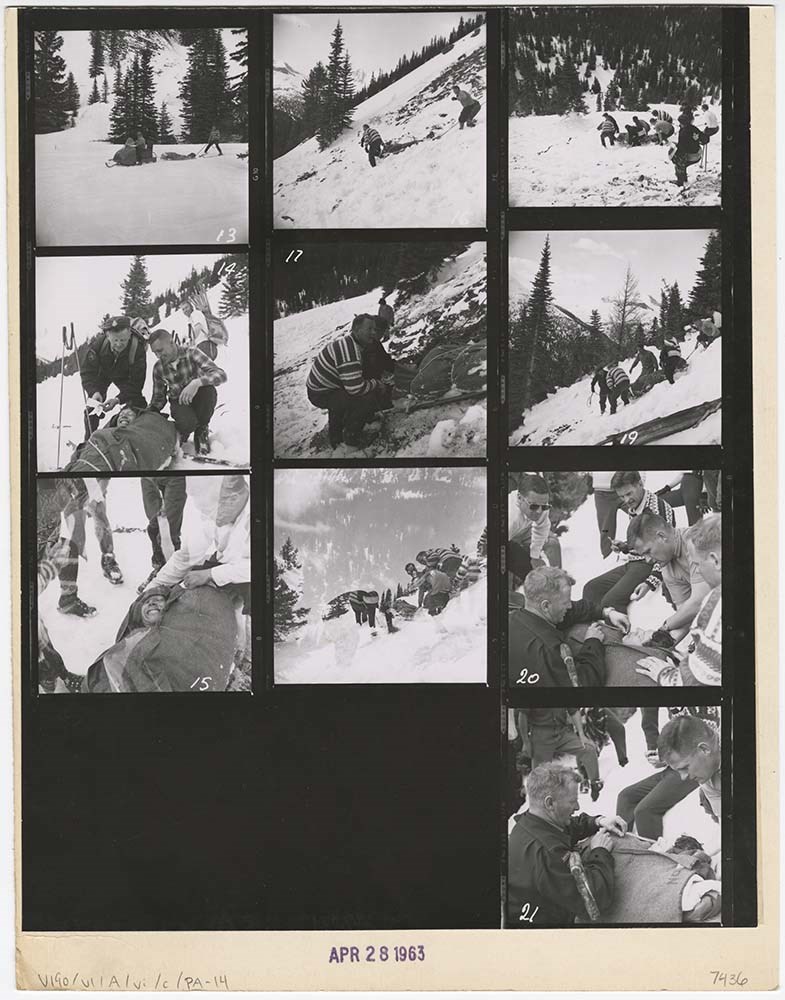
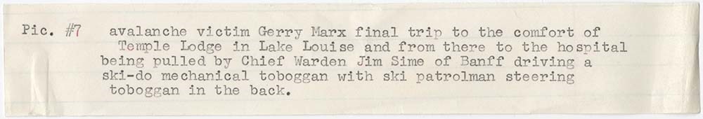
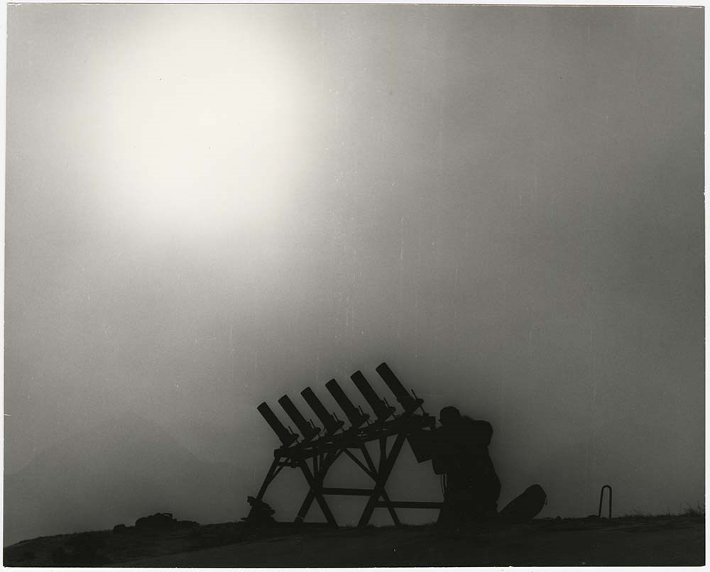
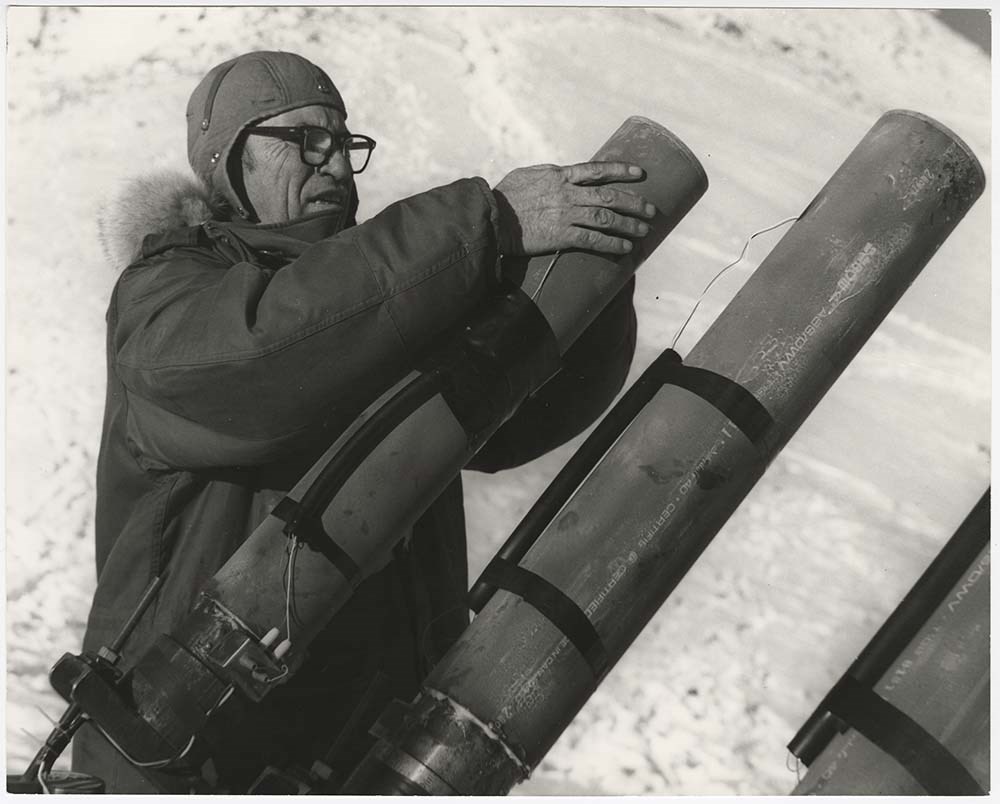
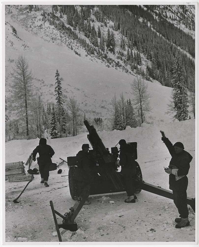
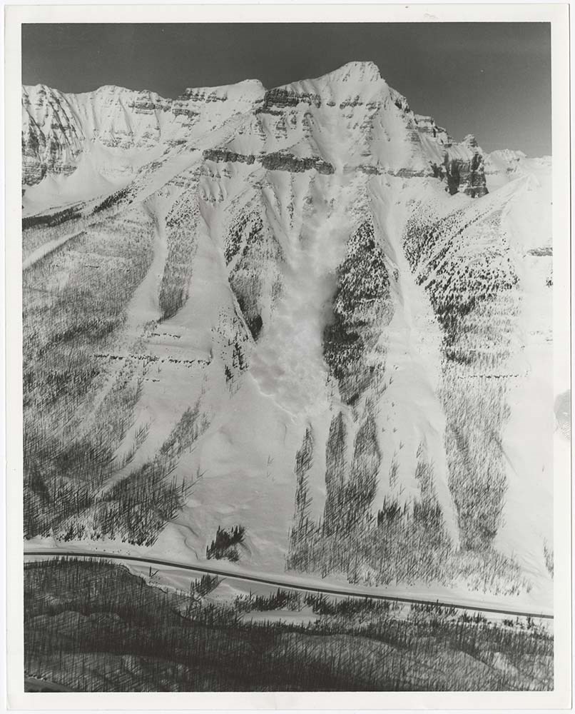
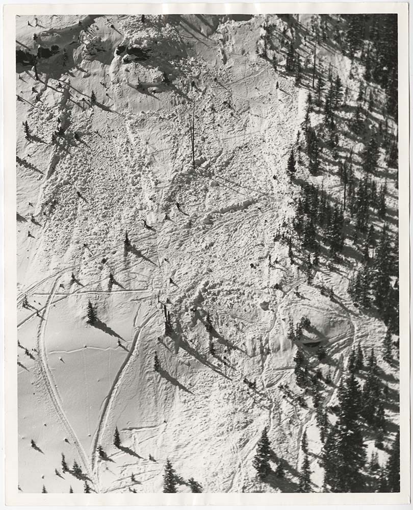
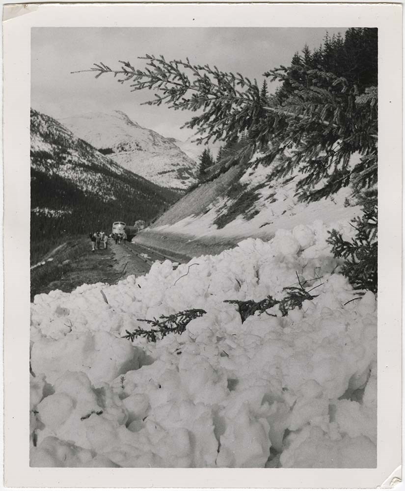
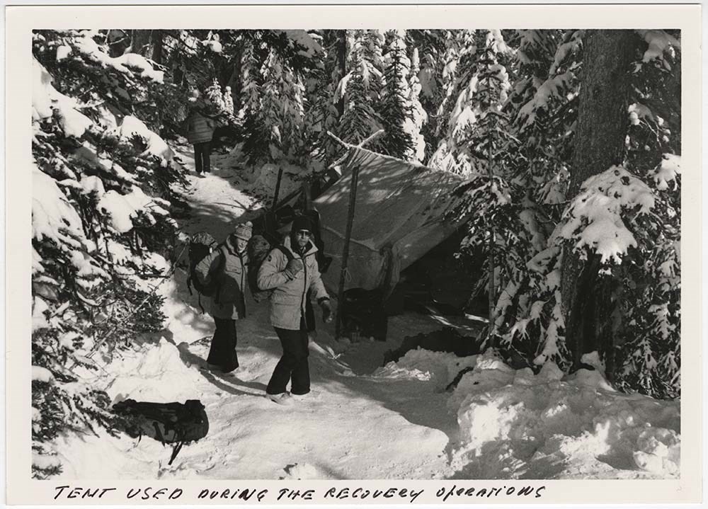
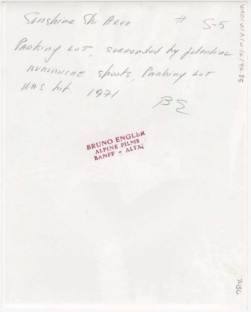
Avalanche Control [1/2]
https://archives.whyte.org/en/permalink/descriptions56748
- Part Of
- Bruno Engler fonds
- Scope & Content
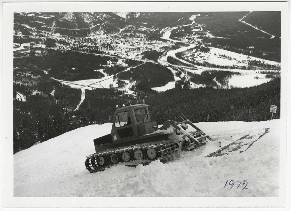
- File pertains to 62 b&w prints of various avalanche control operations around Banff National Park, usually along highways and around ski hills. Also includes photographs from a rescue operation and accompanying news clippings pertaining to that rescue.
- Date Range
- 1956-1979
- Reference Code
- V190 / VI / A / vi / c / PA - 01 to PA - 62
- Description Level
- 5 / File
- GMD
- Photograph
17 images
- Part Of
- Bruno Engler fonds
- Description Level
- 5 / File
- Fonds Number
- M323 / S40 / V190
- Series
- VI : Retained file, A : Alphabetical order
- Sous-Fonds
- V190
- Sub-Series
- vi : Avalanches, c : Control
- Accession Number
- 7436
- Reference Code
- V190 / VI / A / vi / c / PA - 01 to PA - 62
- GMD
- Photograph
- Date Range
- 1956-1979
- Physical Description
- 62 photographs : b&w ; 20.3 x 25.4 cm or smaller
- History / Biographical
- See fonds level description
- Scope & Content
- File pertains to 62 b&w prints of various avalanche control operations around Banff National Park, usually along highways and around ski hills. Also includes photographs from a rescue operation and accompanying news clippings pertaining to that rescue.
- Notes
- Photographs included in this entry were originally housed in a photo paper box identified by Bruno Engler prior to accessioning.
- Subject Access
- Aerial photography
- Avalanches
- Banff-Jasper Highway
- Lake Louise Ski Area
- Mountains
- Rescue
- Rogers Pass
- Ski areas
- Sunshine Ski Resort
- Winter
- Geographic Access
- Banff National Park
- Jasper National Park
- Alberta
- Language
- English
- Conservation
- PA - 25 has two overlapping pieces of masking tape on the back, holding the two torn pieces of the print together
- Creator
- Engler, Bruno
- Title Source
- Original title kept
- Processing Status
- Processed
Images


This material is presented as originally created; it may contain outdated cultural descriptions and
potentially offensive content.
Read more.
Avalanche Control [2/2]
https://archives.whyte.org/en/permalink/descriptions57495
- Part Of
- Bruno Engler fonds
- Scope & Content
- File pertains to 6 boards with b&w negative contact sheets adhered to them depicting various areas prone to avalanches taken from a plane or helicopter. Includes views of ski areas and roads.
- Date Range
- 1956-1979
- Reference Code
- V190 / VI / A / vi / c / PA - 63 to PA - 68
- Description Level
- 5 / File
- GMD
- Photograph
- Part Of
- Bruno Engler fonds
- Description Level
- 5 / File
- Fonds Number
- M323 / S40 / V190
- Series
- VI : Retained file, A : Alphabetical order
- Sous-Fonds
- V190
- Sub-Series
- vi : Avalanches, c : Control
- Accession Number
- 7436
- Reference Code
- V190 / VI / A / vi / c / PA - 63 to PA - 68
- GMD
- Photograph
- Date Range
- 1956-1979
- Physical Description
- 6 photographs : b&w ; 23.4 x 34.2 cm or smaller
- History / Biographical
- See fonds level description
- Scope & Content
- File pertains to 6 boards with b&w negative contact sheets adhered to them depicting various areas prone to avalanches taken from a plane or helicopter. Includes views of ski areas and roads.
- Notes
- File came from box XVI, separate from alphabetised boxes
- Subject Access
- Aerial photography
- Avalanches
- Banff-Jasper Highway
- Lake Louise Ski Area
- Mountains
- Rescue
- Rogers Pass
- Ski areas
- Sunshine Ski Resort
- Winter
- Geographic Access
- Banff National Park
- Jasper National Park
- Alberta
- Language
- English
- Creator
- Engler, Bruno
- Title Source
- Original title kept
- Processing Status
- Processed
This material is presented as originally created; it may contain outdated cultural descriptions and
potentially offensive content.
Read more.
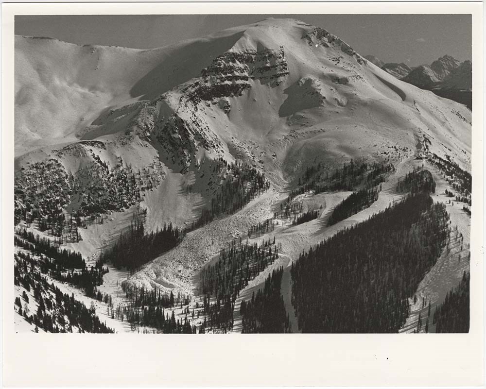
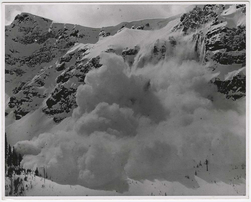
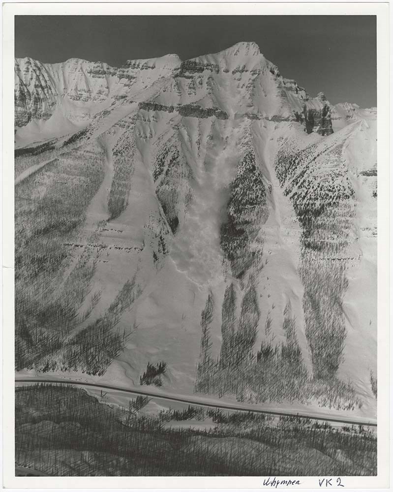
Avalanche Zones
https://archives.whyte.org/en/permalink/descriptions56753
- Part Of
- Bruno Engler fonds
- Scope & Content
- File pertains to 58 b&w prints of various avalanche areas and slides around Banff National Park, mostly focussed along stretches of highways and in and around ski areas, including backcountry ski areas like Assiniboine.
- Date Range
- [ca. 1977-1990]
- Reference Code
- V190 / VI / A / vi / d / PA - 01 to PA - 58
- Description Level
- 5 / File
- GMD
- Photograph
4 images
- Part Of
- Bruno Engler fonds
- Description Level
- 5 / File
- Fonds Number
- M323 / S40 / V190
- Series
- VI : Retained file, A : Alphabetical order
- Sous-Fonds
- V190
- Sub-Series
- vi : Avalanches, d : Zones
- Accession Number
- 7436
- Reference Code
- V190 / VI / A / vi / d / PA - 01 to PA - 58
- GMD
- Photograph
- Date Range
- [ca. 1977-1990]
- Physical Description
- 58 photographs : b&w ; 20.3 x 25.4 cm or smaller
- History / Biographical
- See fonds level description
- Scope & Content
- File pertains to 58 b&w prints of various avalanche areas and slides around Banff National Park, mostly focussed along stretches of highways and in and around ski areas, including backcountry ski areas like Assiniboine.
- Subject Access
- Aerial photography
- Avalanches
- Banff-Jasper Highway
- Backcountry skiing
- Lake Louise Ski Area
- Mountains
- Ski areas
- Sunshine Ski Resort
- Winter
- Geographic Access
- Banff National Park
- Alberta
- Mount Assiniboine
- Mount Assiniboine Provincial Park
- British Columbia
- Language
- English
- Related Material
- V190 / VI / A / vi / d / NA - 01 to NA - 09
- Creator
- Engler, Bruno
- Title Source
- Original title kept
- Processing Status
- Processed
Images
This material is presented as originally created; it may contain outdated cultural descriptions and
potentially offensive content.
Read more.
Avalanche Zones - negatives [1/2]
https://archives.whyte.org/en/permalink/descriptions56754
- Part Of
- Bruno Engler fonds
- Scope & Content
- File pertains to 9 b&w negatives of various avalanche areas and slides around Banff National Park, mostly focussed in and around ski areas.
- Date Range
- [ca. 1977-1990]
- Reference Code
- V190 / VI / A / vi / d / NA - 01 to NA - 09
- Description Level
- 5 / File
- GMD
- Negative
- Part Of
- Bruno Engler fonds
- Description Level
- 5 / File
- Fonds Number
- M323 / S40 / V190
- Series
- VI : Retained file, A : Alphabetical order
- Sous-Fonds
- V190
- Sub-Series
- vi : Avalanches, d : Zones
- Accession Number
- 7436
- Reference Code
- V190 / VI / A / vi / d / NA - 01 to NA - 09
- GMD
- Negative
- Date Range
- [ca. 1977-1990]
- Physical Description
- 9 photographs : b&w negatives ; 15.6 x 6.1 cm or smaller
- History / Biographical
- See fonds level description
- Scope & Content
- File pertains to 9 b&w negatives of various avalanche areas and slides around Banff National Park, mostly focussed in and around ski areas.
- Subject Access
- Aerial photography
- Avalanches
- Banff-Jasper Highway
- Backcountry skiing
- Lake Louise Ski Area
- Mountains
- Ski areas
- Sunshine Ski Resort
- Winter
- Geographic Access
- Banff National Park
- Alberta
- Language
- English
- Related Material
- V190 / VI / A / vi / d / PA - 01 to PA - 58
- Creator
- Engler, Bruno
- Title Source
- Original title kept
- Processing Status
- Processed
This material is presented as originally created; it may contain outdated cultural descriptions and
potentially offensive content.
Read more.
Avalanche Zones - negatives [2/2]
https://archives.whyte.org/en/permalink/descriptions57531
- Part Of
- Bruno Engler fonds
- Scope & Content
- File pertains to 271 b&w negatives of various avalanche areas and slides around Banff National Park, mostly focussed in and around ski areas and highways, including Sunshine Resort, Lake Louise Ski Hill, Kootenay National Park, and the Banff-Jasper Highway. Also includes contact prints.
- Date Range
- 1975-1985
- Reference Code
- V190 / VI / A / vi / d / NA - 10 to NA - 22
- Description Level
- 5 / File
- GMD
- Negative
- Part Of
- Bruno Engler fonds
- Description Level
- 5 / File
- Fonds Number
- M323 / S40 / V190
- Series
- VI : Retained file, A : Alphabetical order
- Sous-Fonds
- V190
- Sub-Series
- vi : Avalanches, d : Zones
- Accession Number
- 7436
- Reference Code
- V190 / VI / A / vi / d / NA - 10 to NA - 22
- GMD
- Negative
- Date Range
- 1975-1985
- Physical Description
- 271 photographs : b&w negatives ; 15.6 x 6.1 cm or smaller
- History / Biographical
- See fonds level description
- Scope & Content
- File pertains to 271 b&w negatives of various avalanche areas and slides around Banff National Park, mostly focussed in and around ski areas and highways, including Sunshine Resort, Lake Louise Ski Hill, Kootenay National Park, and the Banff-Jasper Highway. Also includes contact prints.
- Notes
- File came from box XVI, separate from alphabetised boxes. Photographs were ordered alphabetically by Engler prior to accessioning.
- Name Access
- Davies, Jim
- White, Cliff
- Subject Access
- Aerial photography
- Avalanches
- Banff-Jasper Highway
- Backcountry skiing
- Lake Louise Ski Area
- Mountains
- Ski areas
- Sunshine Ski Resort
- Winter
- Geographic Access
- Banff National Park
- Alberta
- Language
- English
- Related Material
- V190 / VI / A / vi / d / PA - 01 to PA - 58
- Creator
- Engler, Bruno
- Title Source
- Original title kept
- Processing Status
- Processed
This material is presented as originally created; it may contain outdated cultural descriptions and
potentially offensive content.
Read more.
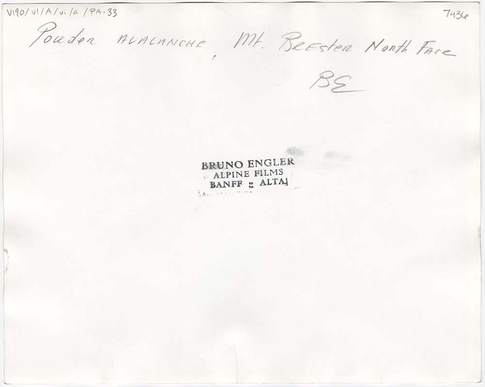
- Part Of
- Bruno Engler fonds
- Scope & Content
- File pertains to 43 b&w prints of avalanches and avalanche control operations around Banff National Park, usually at various ski hills.
- Date Range
- [ca. 1960-1976]
- Reference Code
- V190 / VI / A / vi / a / PA - 01 to PA - 43
- Description Level
- 5 / File
- GMD
- Photograph
10 images
- Part Of
- Bruno Engler fonds
- Description Level
- 5 / File
- Fonds Number
- M323 / S40 / V190
- Series
- VI : Retained file, A : Alphabetical order
- Sous-Fonds
- V190
- Sub-Series
- vi : Avalanches
- Accession Number
- 7436
- Reference Code
- V190 / VI / A / vi / a / PA - 01 to PA - 43
- GMD
- Photograph
- Date Range
- [ca. 1960-1976]
- Physical Description
- 43 photographs : b&w ; 25.4 x 20.3 cm
- History / Biographical
- See fonds level description
- Scope & Content
- File pertains to 43 b&w prints of avalanches and avalanche control operations around Banff National Park, usually at various ski hills.
- Name Access
- Auger, Tim
- Subject Access
- Avalanches
- Lake Louise Ski Area
- Mountains
- Ski areas
- Sunshine Ski Resort
- Winter
- Geographic Access
- Banff
- Banff National Park
- Alberta
- Language
- English
- Creator
- Engler, Bruno
- Title Source
- Original title kept
- Processing Status
- Processed
Images


This material is presented as originally created; it may contain outdated cultural descriptions and
potentially offensive content.
Read more.
Balfour Hut Registers
https://archives.whyte.org/en/permalink/descriptions57646
- Part Of
- Alpine Club of Canada fonds
- Scope & Content
- Sub-series of hut registers from the Balfour (Rob Ritchie) Hut produced by the Alpine Club of Canada between 1966 and 2019. Registers include entries from visitors to the huts which pertain to individuals' hiking and climbing trips; details of specific events which occurred while staying at the hut…
- Date Range
- 1966-2001
- 2007-2019
- Reference Code
- M200 / IV / I
- Description Level
- 4 / Sub-series
- GMD
- Textual record
- Organization record
- Part Of
- Alpine Club of Canada fonds
- Description Level
- 4 / Sub-series
- Fonds Number
- M200
- V14
- S6
- Series
- M200 / IV: Hut Registers
- Sous-Fonds
- M200
- Sub-Series
- M200 / IV / I: Balfour Hut Registers
- Accession Number
- accn. 2376
- accn. 3298
- accn. 3560
- accn. 7779
- accn. 2023.10
- accn. 2023.31
- accn. 2023.15
- Reference Code
- M200 / IV / I
- Responsibility
- Registers produced by Alpine Club of Canada
- Date Range
- 1966-2001
- 2007-2019
- Physical Description
- 20 cm of textual records 9 volumes
- History / Biographical
- According to the Alpine Club of Canada's website: "The Rob Ritchie Hut, also known as the Balfour Hut, is found on low, rocky hills at the toe of the Vulture Glacier, approximately 28 km northwest of the town of Lake Louise, AB. It is east of Balfour Pass and the Continental divide, just inside the Banff National Park boundary.[...] The Rob Ritchie Hut, also known as the Balfour Hut, is found on low, rocky hills at the toe of the Vulture Glacier, approximately 28 km northwest of the town of Lake Louise, AB. It is east of Balfour Pass and the Continental divide, just inside the Banff National Park boundary. This is the half-way mark for the Wapta Traverse and is usually used in conjunction with the other huts in this chain while attempting this classic cross-glacier ski trip. Usual approach is from Bow Hut through the Olive/St. Nicholas Col then down the gentle and pleasant Vulture Glacier to Balfour Pass, where the hut sits on a section of moraine beneath the impressive bulk of Mt. Balfour. Though most people will spend one night at the R.J. Ritchie (Balfour) Hut before continuing on to Scott Duncan, there is potential for good skiing here, especially on the Diableret Glacier which sits northwest of Mt. Balfour and makes for a fantastic run on a clear day! There is also an optional route to the summit of Mt. Gordon from this hut, which would be an excellent loop trip if combined with the normal route back towards Bow Hut. Use your imagination and some neat trip ideas will present themselves!"
- Scope & Content
- Sub-series of hut registers from the Balfour (Rob Ritchie) Hut produced by the Alpine Club of Canada between 1966 and 2019. Registers include entries from visitors to the huts which pertain to individuals' hiking and climbing trips; details of specific events which occurred while staying at the hut, wildlife sightings, custodial issues and updates, and related topics. The sub-series is separated into individual hut registers, arranged by date:
- M200 / IV / I / 1: Balfour Hut [Register] [1966-1971]
- M200 / IV / I / 2: Balfour Pass Hut [1971-1972]
- M200 / IV / I / 3: Balfour Pass Hut Register [1973-1974]
- M200 / IV / I / 4: Balfour Pass Hut [register 1974-1982]
- M200 / IV / I / 5: "Balfour Hut" [register] Sept. 2, 1982 - Nov. 17, 1989
- M200 / IV / I / 6: Balfour Hut Journal Nov. 22, 1989 - Apr. 25, 1997
- M200 / IV / I / 7: Balfour Hut Register [1997 -2001]
- M200 / IV / I / 8: Balfour Hut Register 2007 - 2015
- M200 / IV / I / 9: Balfour Hut register 2011 - 2019
- Name Access
- Alpine Club of Canada
- Subject Access
- Huts
- Cabins
- Cabins and shelters
- Backcountry skiing
- Banff National Park
- Buildings and facilities
- Climbing
- Environment and Nature
- Lake Louise
- Mountaineering
- Mountains
- Ski mountaineering
- Sports and leisure
- Sports and recreation
- Winter sports
- Wapta Traverse
- Geographic Access
- Canada
- Alberta
- Banff National Park
- Lake Louise, AB
- Access Restrictions
- Restrictions may apply
- Language
- English
- French
- German
- Japanese
- Spanish
- Biographical Source Notes
- Alpine Club of Canada website: https://www.alpineclubofcanada.ca/rob-ritchie-balfour-hut/"
- Title Source
- Title based on contents of sub-series
- Processing Status
- Processed
This material is presented as originally created; it may contain outdated cultural descriptions and
potentially offensive content.
Read more.
Banff National Park and Lake Louise maps
https://archives.whyte.org/en/permalink/descriptions54945
- Scope & Content
- File consists of two folded maps and a small clipping [possibly top or bottom portion from a different map or one of maps in file]. One map is of Banff National Park and one is of Lake Louise [1959]. Banff National Park map has black pencil tracings over trail section near the bottom of the map and…
- Date Range
- 1959
- [1960-1970]
- Reference Code
- M545 / V / 53
- Description Level
- 5 / File
- GMD
- Textual record
- Published record
- Map
- Description Level
- 5 / File
- Fonds Number
- M545 / V635
- Series
- M545 / V : Administrative records
- Sous-Fonds
- M545
- Accession Number
- 8235
- Reference Code
- M545 / V / 53
- Date Range
- 1959
- [1960-1970]
- Physical Description
- 0.5 cm of textual records (2 maps ; 60.5 x 57.5 and 60 x 56.5 cm)
- Scope & Content
- File consists of two folded maps and a small clipping [possibly top or bottom portion from a different map or one of maps in file]. One map is of Banff National Park and one is of Lake Louise [1959]. Banff National Park map has black pencil tracings over trail section near the bottom of the map and annotation in bottom right corner which reads "Natural Bridge". Lake Louise map produced by the Government of Canada.
- Subject Access
- Banff National Park
- Environment
- Geography
- Map
- Lake Louise
- Travel
- Government
- National parks and reserves
- Trails
- Geographic Access
- Canada
- Alberta
- Banff National Park
- Lake Louise
- Language
- English
- Conservation
- Clipping stored in mylar due to significant staining and residue from tape
- Items kept folded [not placed in mylar] due to mass production of content and minimal/no annotations
- Title Source
- Title based on contents of file
- Processing Status
- Processed
This material is presented as originally created; it may contain outdated cultural descriptions and
potentially offensive content.
Read more.