Narrow Results By
Hiking trails in the Lake Louise, Paradise Valley, Moraine Lake and Lake O'Hara areas
https://archives.whyte.org/en/permalink/catalogue24326
- Medium
- Library - Maps and blueprints (unannotated; published)
- Map
- Published Date
- 1959?
- Publisher
- Ottawa: Canadian Government Travel Bureau
- Call Number
- C6-4.3pb
- Publisher
- Ottawa: Canadian Government Travel Bureau
- Published Date
- 1959?
- Physical Description
- 1 map : col
- Scale
- 3/4 inch = 1 mile
- Subjects
- Lake Louise region
- Lake O'Hara region
- Notes
- Textual information on reverse. Compiled in cooperation with The National Parks of Canada.
- Info file transfer
- Call Number
- C6-4.3pb
- Collection
- Archives Library
This material is presented as originally created; it may contain outdated cultural descriptions and
potentially offensive content.
Read more.
Hiking trails in the Lake Louise, Paradise Valley, Moraine Lake and Lake O'Hara areas
https://archives.whyte.org/en/permalink/catalogue23393
- Medium
- Library - Maps and blueprints (unannotated; published)
- Map
- Published Date
- 1959?
- Publisher
- Ottawa: Canadian Government Travel Bureau
- Call Number
- C6-4.3pb
- Publisher
- Ottawa: Canadian Government Travel Bureau
- Published Date
- 1959?
- Physical Description
- 1 map : col
- Scale
- 3/4 inch = 1 mile
- Subjects
- Lake Louise region
- Lake O'Hara region
- Notes
- Textual information on reverse. Compiled in cooperation with The National Parks of Canada.
- Info file transfer
- Call Number
- C6-4.3pb
- Collection
- Archives Library
This material is presented as originally created; it may contain outdated cultural descriptions and
potentially offensive content.
Read more.
- Date
- 1914 – 1925
- Medium
- graphite on paper
- Catalogue Number
- WyP.03.663
- Description
- A pencil drawing of a castle with battlements topped with various nations’ flags, possibly American, British, and French. At the top is the title ICE PALACE.
1 image
- Title
- Ice Palace
- Date
- 1914 – 1925
- Medium
- graphite on paper
- Dimensions
- 15.0 x 22.5 cm
- Description
- A pencil drawing of a castle with battlements topped with various nations’ flags, possibly American, British, and French. At the top is the title ICE PALACE.
- Subject
- ice palace
- castle
- flag
- ice
- Lake Louise
- Credit
- Gift of Catharine Robb Whyte, O. C., Banff, 1979
- Catalogue Number
- WyP.03.663
Images

This material is presented as originally created; it may contain outdated cultural descriptions and
potentially offensive content.
Read more.
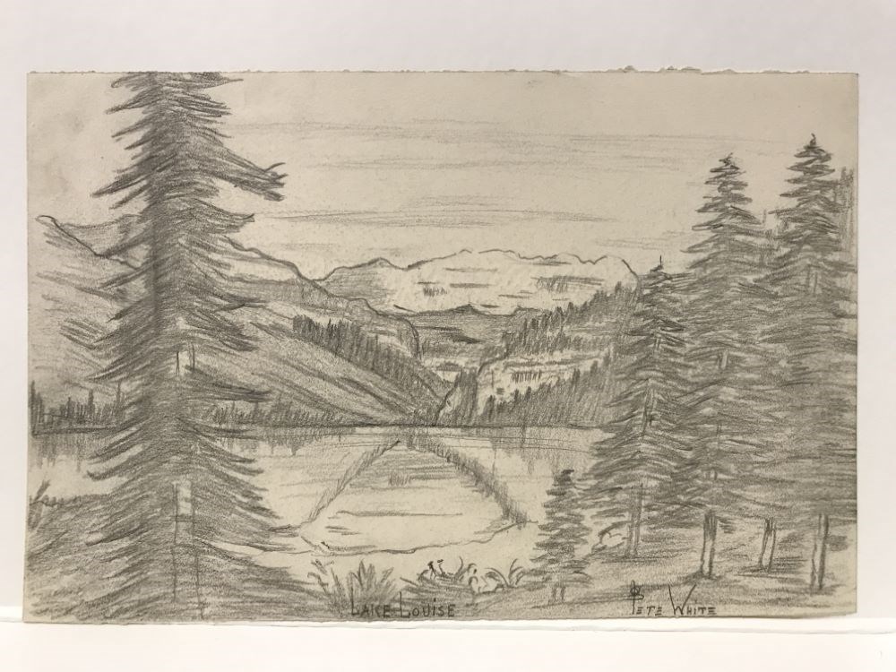
- Date
- c. 1921
- Medium
- graphite on paper
- Catalogue Number
- WyP.03.950 r
- Description
- Lake Louise
1 image
- Title
- Lake Louise
- Date
- c. 1921
- Medium
- graphite on paper
- Dimensions
- 16.5 x 25.5 cm
- Description
- Lake Louise
- Subject
- Lake Louise
- mountain
- lake
- tree
- Credit
- Gift of Catharine Robb Whyte, O. C., Banff, 1975
- Catalogue Number
- WyP.03.950 r
Images
This material is presented as originally created; it may contain outdated cultural descriptions and
potentially offensive content.
Read more.
[Lake Louise 82N/8 East, Alberta-B.C.]
https://archives.whyte.org/en/permalink/catalogue23711
- Medium
- Library - Maps and blueprints (unannotated; published)
- Map
- Published Date
- 1959
- Publisher
- Dept. of Mines and Technical Surveys
- Call Number
- NTS
- 82N/8E
- Publisher
- Dept. of Mines and Technical Surveys
- Published Date
- 1959
- Physical Description
- 1 map : col
- Scale
- Scale: 1:50,000
- Relief: Contour interval 100'
- Subjects
- Lake Louise
- Alberta/British Columbia
- Notes
- National Topographic System
- Accession Number
- 6283
- Call Number
- NTS
- 82N/8E
- Collection
- Archives Library
This material is presented as originally created; it may contain outdated cultural descriptions and
potentially offensive content.
Read more.
[Lake Louise 82N/8 West, Alberta-B.C.]
https://archives.whyte.org/en/permalink/catalogue23712
- Medium
- Library - Maps and blueprints (unannotated; published)
- Map
- Published Date
- 1959
- Publisher
- Dept. of Mines and Technical Surveys
- Call Number
- NTS
- 82N/8W
- Publisher
- Dept. of Mines and Technical Surveys
- Published Date
- 1959
- Physical Description
- 1 map : col
- Scale
- Scale: 1:50,000
- Relief: Contour interval 100'
- Subjects
- Lake Louise
- Alberta/British Columbia
- Notes
- National Topographic System
- Call Number
- NTS
- 82N/8W
- Collection
- Archives Library
This material is presented as originally created; it may contain outdated cultural descriptions and
potentially offensive content.
Read more.
[Lake Louise 82N/8W]
https://archives.whyte.org/en/permalink/catalogue23713
- Medium
- Library - Maps and blueprints (unannotated; published)
- Map
- Published Date
- 1972 overprint
- Publisher
- Department of Energy, Mines and Resources
- Call Number
- NTS
- 82N/8W
- Publisher
- Department of Energy, Mines and Resources
- Published Date
- 1972 overprint
- Physical Description
- 1 map : col
- Scale
- Scale: 1:50,000
- Relief: Contour interval 100 ft.
- Subjects
- Lake Louise
- Notes
- National Topographic System
- Accession Number
- 5500
- Call Number
- NTS
- 82N/8W
- Collection
- Archives Library
This material is presented as originally created; it may contain outdated cultural descriptions and
potentially offensive content.
Read more.
[Lake Louise Alberta-B.C.]
https://archives.whyte.org/en/permalink/catalogue23710
- Medium
- Library - Maps and blueprints (unannotated; published)
- Map
- Published Date
- 1980
- Publisher
- Dept. of Energy Mines and Resources
- Edition
- Edition 2
- Call Number
- NTS
- 82N/8
- Edition
- Edition 2
- Publisher
- Dept. of Energy Mines and Resources
- Published Date
- 1980
- Physical Description
- 1 map : col
- Scale
- Scale: 1:50,000
- Relief: Contour Interval 100 ft.
- Subjects
- Lake Louise
- Alberta/British Columbia
- Accession Number
- 3,000
- Call Number
- NTS
- 82N/8
- Collection
- Archives Library
This material is presented as originally created; it may contain outdated cultural descriptions and
potentially offensive content.
Read more.
[Lake Louise, Moraine Lake and Vermilion Pass]
https://archives.whyte.org/en/permalink/catalogue24616
- Medium
- Library - Maps and blueprints (unannotated; published)
- Map
- Published Date
- 1905
- Publisher
- Dept. of the Interior
- Call Number
- C3-2.1(b)
- Publisher
- Dept. of the Interior
- Published Date
- 1905
- Physical Description
- Colour
- Scale
- Scale: 1:60,000
- Relief: Contour interval 500 ft.
- Accession Number
- 400
- Call Number
- C3-2.1(b)
- Collection
- Archives Library
This material is presented as originally created; it may contain outdated cultural descriptions and
potentially offensive content.
Read more.
Lake Louise [townsite]
https://archives.whyte.org/en/permalink/catalogue23281
- Medium
- Library - Maps and blueprints (unannotated; published)
- Map
- Published Date
- 1989
- Publisher
- Calgary: Parks Canada Western Region?
- Call Number
- C4-2.2a
- Publisher
- Calgary: Parks Canada Western Region?
- Published Date
- 1989
- Physical Description
- 1 map : col
- Scale
- Scale indeterminable
- Subjects
- Lake Louise Visitors Centre
- Call Number
- C4-2.2a
- Collection
- Archives Library
This material is presented as originally created; it may contain outdated cultural descriptions and
potentially offensive content.
Read more.