Narrow Results By
Plan of Banff, Rocky Mountains Park, Alberta
https://archives.whyte.org/en/permalink/catalogue23256
- Medium
- Library - Maps and blueprints (unannotated; published)
- Map
- Published Date
- 1981
- Publisher
- Dept. of the Interior, Canada
- Call Number
- C4-1.3a
- Responsibility
- Ottawa: Association of Canadian Map Libraries in cooperation with Iain C. Taylor
- Publisher
- Dept. of the Interior, Canada
- Published Date
- 1981
- Physical Description
- 1 map : black and white
- Scale
- Scale: 1 inch = 400 feet
- Notes
- Facsimile/Association of Canadian Map Libraries; no. 29
- Reproduced from original in National Map Collection, Public Archives Canada (ca 1917)
- 1920. Limited edition, Copy 452
- Accession Number
- 3465
- 6073
- Call Number
- C4-1.3a
- Collection
- Archives Library
This material is presented as originally created; it may contain outdated cultural descriptions and
potentially offensive content.
Read more.
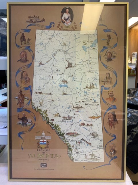
Province of Alberta Heritage Map
https://archives.whyte.org/en/permalink/artifacttuj.04.01
- Date
- 1980
- Medium
- print on paper
- Catalogue Number
- TuJ.04.01
- Description
- Off-white coloured map of alberta with blue bodies of water, green mppuntain rangte, and coloured drawings of animals, points of interest, and people. Brown background around map with blue ribbons and portraits of significant people, including Queen Elizabeth II at top. The Alberta coat of arms is …
1 image
- Title
- Province of Alberta Heritage Map
- Date
- 1980
- Medium
- print on paper
- Dimensions
- 91.0 x 96.0 cm
- Description
- Off-white coloured map of alberta with blue bodies of water, green mppuntain rangte, and coloured drawings of animals, points of interest, and people. Brown background around map with blue ribbons and portraits of significant people, including Queen Elizabeth II at top. The Alberta coat of arms is at bottom left with “1905” “1980” “PROVINCE OF ALBERTA HERITAGE MAP COMMISSIONED BY Alberta Historical Resources Foundation” Signed J.D. TURNER bottom right. In thin brass frame with glass.
- Credit
- Gift of John Davenall Turner (Estate), 2020
- Catalogue Number
- TuJ.04.01
Images
This material is presented as originally created; it may contain outdated cultural descriptions and
potentially offensive content.
Read more.
North West Territories
https://archives.whyte.org/en/permalink/catalogue21483
- Medium
- Library - Maps and blueprints (unannotated; published)
- Map
- Published Date
- 1787
- Author
- Pond, Peter
- Call Number
- C12-1.8
- Author
- Pond, Peter
- Published Date
- 1787
- Subjects
- Peter Pond's Map
- Notes
- Photostatic copy from Public Archives
- three sections
- Accession Number
- 675
- Call Number
- C12-1.8
- Collection
- Archives Library
This material is presented as originally created; it may contain outdated cultural descriptions and
potentially offensive content.
Read more.
North West Territories
https://archives.whyte.org/en/permalink/catalogue21484
- Medium
- Library - Maps and blueprints (unannotated; published)
- Map
- Published Date
- 1787
- Author
- Pond, Peter
- Call Number
- C12-1.8(d)
- Author
- Pond, Peter
- Published Date
- 1787
- Subjects
- Peter Pond's Map
- Notes
- Accompanies 02.5/P77w
- Smaller scale of maps: C12-1.8 (a) (b) (c)
- Accession Number
- 400
- Call Number
- C12-1.8(d)
- Collection
- Archives Library
This material is presented as originally created; it may contain outdated cultural descriptions and
potentially offensive content.
Read more.
Map of North America
https://archives.whyte.org/en/permalink/catalogue21481
- Medium
- Library - Maps and blueprints (unannotated; published)
- Map
- Published Date
- 1785
- Author
- Pond, Peter
- Call Number
- C12-1.7
- Author
- Pond, Peter
- Published Date
- 1785
- Subjects
- Peter Pond's Map
- Notes
- Photostatic copy from Public Archives
- Accession Number
- 675
- Call Number
- C12-1.7
- Collection
- Archives Library
This material is presented as originally created; it may contain outdated cultural descriptions and
potentially offensive content.
Read more.
Map of North America
https://archives.whyte.org/en/permalink/catalogue21482
- Medium
- Library - Maps and blueprints (unannotated; published)
- Map
- Published Date
- 1785
- Author
- Pond, Peter
- Call Number
- C12-1.7(a)
- Author
- Pond, Peter
- Published Date
- 1785
- Subjects
- Peter Pond's Map
- Notes
- Photostatic copy from Public Archives
- Accession Number
- 400
- Call Number
- C12-1.7(a)
- Collection
- Archives Library
This material is presented as originally created; it may contain outdated cultural descriptions and
potentially offensive content.
Read more.
David and Rose Scollard project
https://archives.whyte.org/en/permalink/descriptions56015
- Part Of
- Ben Gadd fonds
- Scope & Content
- File consists of Sample copies of a map which Ben Gadd produced and sent to David and Rose Scollard for use in their book, "No Man's Land", and related correspondence. Map pertains to battle sites in France during the First World War.
- Date Range
- 1980-1981
- Reference Code
- M590 / III / D / 41
- Description Level
- 5 / File
- GMD
- Textual record
- Part Of
- Ben Gadd fonds
- Description Level
- 5 / File
- Fonds Number
- M590
- V810
- S61
- Series
- M590 / III : Professional records
- Sous-Fonds
- M590
- Sub-Series
- M590 / III / D : Other contracts and projects
- Accession Number
- 2021.20
- Reference Code
- M590 / III / D / 41
- GMD
- Textual record
- Date Range
- 1980-1981
- Physical Description
- 0.2 cm of textual records
- Scope & Content
- File consists of Sample copies of a map which Ben Gadd produced and sent to David and Rose Scollard for use in their book, "No Man's Land", and related correspondence. Map pertains to battle sites in France during the First World War.
- Name Access
- Gadd, Ben
- Subject Access
- Research
- Publication
- Geography
- History
- Correspondence
- Map
- War
- World War I
- Geographic Access
- Canada
- Alberta
- Jasper
- England
- France
- Reproduction Restrictions
- Restrictions may apply
- Language
- English
- Title Source
- Original title used
- Processing Status
- Processed
This material is presented as originally created; it may contain outdated cultural descriptions and
potentially offensive content.
Read more.
Maligne Lake tear-off map
https://archives.whyte.org/en/permalink/descriptions56073
- Part Of
- Ben Gadd fonds
- Scope & Content
- File consists of documents pertaining to the creation of a tear-off map of Maligne Lake, which Ben Gadd produced for Parks Canada while working as a Seasonal Naturalist in Jasper. File includes a project proposal, textual drafts, visual layout samples, correspondence, invoices and other related mat…
- Date Range
- [ca.1980-1984]
- Reference Code
- M590 / III / A / 10
- Description Level
- 5 / File
- GMD
- Textual record
- Map
- Part Of
- Ben Gadd fonds
- Description Level
- 5 / File
- Fonds Number
- M590
- V810
- S61
- Series
- M590 / III : Professional records
- Sous-Fonds
- M590
- Sub-Series
- M590 / III / A : Parks Canada records
- Accession Number
- 2021.20
- Reference Code
- M590 / III / A / 10
- GMD
- Textual record
- Map
- Responsibility
- Produced by Ben Gadd
- Date Range
- [ca.1980-1984]
- Physical Description
- 1 cm of textual records
- Scope & Content
- File consists of documents pertaining to the creation of a tear-off map of Maligne Lake, which Ben Gadd produced for Parks Canada while working as a Seasonal Naturalist in Jasper. File includes a project proposal, textual drafts, visual layout samples, correspondence, invoices and other related materials.
- Name Access
- Gadd, Ben
- Subject Access
- Parks Canada
- Government
- Environment
- Geography
- Geology
- Natural history
- Map
- Geographic Access
- Canada
- Alberta
- Maligne Lake
- Jasper National Park
- Reproduction Restrictions
- Restrictions may apply
- Language
- English
- Category
- Environment
- Government
- Title Source
- Title based on contents of file
- Processing Status
- Processed
This material is presented as originally created; it may contain outdated cultural descriptions and
potentially offensive content.
Read more.
Park Notebook articles
https://archives.whyte.org/en/permalink/descriptions56074
- Part Of
- Ben Gadd fonds
- Scope & Content
- File consists of research notes, drafts and published copies of articles which Ben Gadd wrote for the "Park Notebook" column in the Jasper Booster newspaper while working for Parks Canada between 1981 and 1984; and notes related to an interpretive teaching guide for Jasper National Park.
- Date Range
- 1981-1984
- Reference Code
- M590 / III / A / 11
- Description Level
- 5 / File
- GMD
- Textual record
- Newspaper clipping
- Part Of
- Ben Gadd fonds
- Description Level
- 5 / File
- Fonds Number
- M590
- V810
- S61
- Series
- M590 / III : Professional records
- Sous-Fonds
- M590
- Sub-Series
- M590 / III / A : Parks Canada records
- Accession Number
- 2021.20
- Reference Code
- M590 / III / A / 11
- Responsibility
- Produced by Ben Gadd, Jasper Booster
- Date Range
- 1981-1984
- Physical Description
- 0.7 cm of textual records
- Scope & Content
- File consists of research notes, drafts and published copies of articles which Ben Gadd wrote for the "Park Notebook" column in the Jasper Booster newspaper while working for Parks Canada between 1981 and 1984; and notes related to an interpretive teaching guide for Jasper National Park.
- Name Access
- Gadd, Ben
- Subject Access
- Parks Canada
- Government
- Environment
- Geography
- Geology
- Wildlife
- Natural history
- Map
- Publication
- Newspaper
- Geographic Access
- Canada
- Alberta
- Jasper National Park
- Jasper
- Reproduction Restrictions
- Restrictions may apply
- Language
- English
- Category
- Environment
- Government
- Title Source
- Title based on contents of file
- Processing Status
- Processed
This material is presented as originally created; it may contain outdated cultural descriptions and
potentially offensive content.
Read more.
Blue Lake Centre Nature Trail guidebook
https://archives.whyte.org/en/permalink/descriptions56119
- Part Of
- Ben Gadd fonds
- Scope & Content
- File consists of drafts, notes and correspondence pertaining to a guidebook for the Blue Lake Centre Nature Trail near Hinton, Alberta. Ben Gadd researched, designed and produced the guidebook for the Blue Lake Centre between 1989 and 1990, while working as a freelance consultant.
- Date Range
- 1989-1990
- Reference Code
- M590 / III / D / 94
- Description Level
- 5 / File
- GMD
- Textual record
- Published record
- Part Of
- Ben Gadd fonds
- Description Level
- 5 / File
- Fonds Number
- M590
- V810
- S61
- Series
- M590 / III : Professional records
- Sous-Fonds
- M590
- Sub-Series
- M590 / III / D : Other contracts and projects
- Accession Number
- 2021.20
- Reference Code
- M590 / III / D / 94
- Responsibility
- Produced by Ben Gadd
- Date Range
- 1989-1990
- Physical Description
- 2 cm of textual records
- Scope & Content
- File consists of drafts, notes and correspondence pertaining to a guidebook for the Blue Lake Centre Nature Trail near Hinton, Alberta. Ben Gadd researched, designed and produced the guidebook for the Blue Lake Centre between 1989 and 1990, while working as a freelance consultant.
- Subject Access
- Research
- Publication
- Guiding
- Map
- Trails
- Natural history
- Education
- Environment
- Hiking
- Sports
- Recreation
- Skiing
- Tourist information
- Wildlife
- Geographic Access
- Canada
- Alberta
- Hinton
- Reproduction Restrictions
- Restrictions may apply
- Language
- English
- Title Source
- Original title used
- Processing Status
- Processed
This material is presented as originally created; it may contain outdated cultural descriptions and
potentially offensive content.
Read more.