Narrow Results By
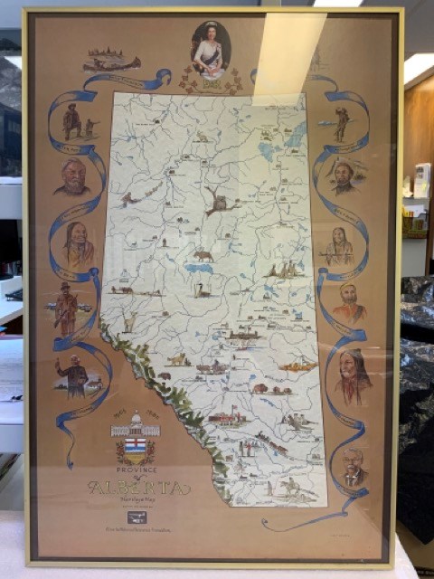
Province of Alberta Heritage Map
https://archives.whyte.org/en/permalink/artifacttuj.04.01
- Date
- 1980
- Medium
- print on paper
- Catalogue Number
- TuJ.04.01
- Description
- Off-white coloured map of alberta with blue bodies of water, green mppuntain rangte, and coloured drawings of animals, points of interest, and people. Brown background around map with blue ribbons and portraits of significant people, including Queen Elizabeth II at top. The Alberta coat of arms is …
1 image
- Title
- Province of Alberta Heritage Map
- Date
- 1980
- Medium
- print on paper
- Dimensions
- 91.0 x 96.0 cm
- Description
- Off-white coloured map of alberta with blue bodies of water, green mppuntain rangte, and coloured drawings of animals, points of interest, and people. Brown background around map with blue ribbons and portraits of significant people, including Queen Elizabeth II at top. The Alberta coat of arms is at bottom left with “1905” “1980” “PROVINCE OF ALBERTA HERITAGE MAP COMMISSIONED BY Alberta Historical Resources Foundation” Signed J.D. TURNER bottom right. In thin brass frame with glass.
- Credit
- Gift of John Davenall Turner (Estate), 2020
- Catalogue Number
- TuJ.04.01
Images
This material is presented as originally created; it may contain outdated cultural descriptions and
potentially offensive content.
Read more.
The Great Lakes and the States that Bound Them
https://archives.whyte.org/en/permalink/artifactwyp.03.514
- Date
- 1917 – 1966
- Medium
- ink on paper
- Catalogue Number
- WyP.03.514
- Description
- Ink drawing of a geographic perspective of the Great Lakes region, including the states that border on Canada
1 image
- Title
- The Great Lakes and the States that Bound Them
- Date
- 1917 – 1966
- Medium
- ink on paper
- Dimensions
- 15.1 x 22.5 cm
- Description
- Ink drawing of a geographic perspective of the Great Lakes region, including the states that border on Canada
- Subject
- map
- Great Lakes
- Canada
- United States
- geography
- Credit
- Gift of Catharine Robb Whyte, O. C., Banff, 1975
- Catalogue Number
- WyP.03.514
Images

This material is presented as originally created; it may contain outdated cultural descriptions and
potentially offensive content.
Read more.
- Date
- 1917 – 1966
- Medium
- ink on drawing
- Catalogue Number
- WyP.03.515
- Description
- An ink drawing of a map of Saskatchewan on paper. Labelled SASKATEWAN [sic] in centre, written vertically towards the top edge.
1 image
- Title
- Untitled
- Date
- 1917 – 1966
- Medium
- ink on drawing
- Dimensions
- 22.5 x 15.1 cm
- Description
- An ink drawing of a map of Saskatchewan on paper. Labelled SASKATEWAN [sic] in centre, written vertically towards the top edge.
- Subject
- map
- Saskatchewan
- province
- Canada
- geography
- Credit
- Gift of Catharine Robb Whyte, O. C., Banff, 1975
- Catalogue Number
- WyP.03.515
Images

This material is presented as originally created; it may contain outdated cultural descriptions and
potentially offensive content.
Read more.
- Date
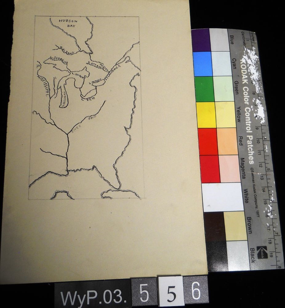
- 1917 – 1929
- Medium
- graphite; ink on paper
- Catalogue Number
- WyP.03.556
- Description
- A pencil and ink drawing of a map of Hudson Bay and the river system in eastern Canada and United States. Includes Great Lakes as well. Bodies of water are labeled.
1 image
- Title
- Untitled
- Date
- 1917 – 1929
- Medium
- graphite; ink on paper
- Dimensions
- 22.5 x 15.1 cm
- Description
- A pencil and ink drawing of a map of Hudson Bay and the river system in eastern Canada and United States. Includes Great Lakes as well. Bodies of water are labeled.
- Subject
- Canada
- Hudson Bay
- rivers
- United States
- U.S.A.
- map
- Credit
- Gift of Catharine Robb Whyte, O. C., Banff, 1979
- Catalogue Number
- WyP.03.556
Images
This material is presented as originally created; it may contain outdated cultural descriptions and
potentially offensive content.
Read more.
Map of Ontario
https://archives.whyte.org/en/permalink/artifactwyp.03.559
- Date
- 1917 – 1929
- Medium
- graphite; ink on paper
- Catalogue Number
- WyP.03.559
- Description
- Pencil and ink drawing of Ontario, the Manitoba border, and Great Lakes with rivers and urban centres labeled.title: MAP OF ONTARIO [top left, surrounded by short marks]
1 image
- Title
- Map of Ontario
- Date
- 1917 – 1929
- Medium
- graphite; ink on paper
- Dimensions
- 15.1 x 22.5 cm
- Description
- Pencil and ink drawing of Ontario, the Manitoba border, and Great Lakes with rivers and urban centres labeled.title: MAP OF ONTARIO [top left, surrounded by short marks]
- Credit
- Gift of Catharine Robb Whyte, O. C., Banff, 1979
- Catalogue Number
- WyP.03.559
Images

This material is presented as originally created; it may contain outdated cultural descriptions and
potentially offensive content.
Read more.
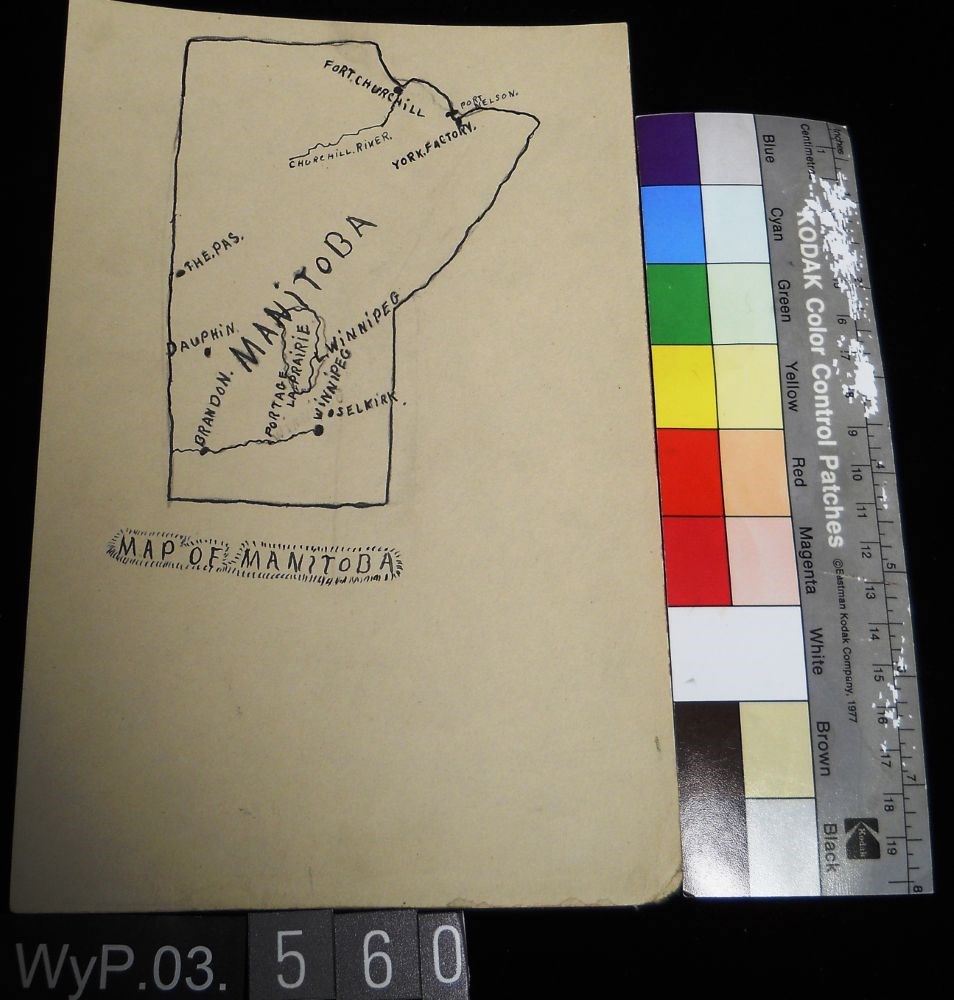
Map of Manitoba
https://archives.whyte.org/en/permalink/artifactwyp.03.560
- Date
- 1917 – 1929
- Medium
- ink; graphite on paper
- Catalogue Number
- WyP.03.560
- Description
- Pencil and ink drawing of a map of Manitoba with rivers, lakes and urban centres labeled. [Below drawing, surrounded by circle of short marks] MAP of MANITOBA
1 image
- Title
- Map of Manitoba
- Date
- 1917 – 1929
- Medium
- ink; graphite on paper
- Dimensions
- 22.5 x 15.1 cm
- Description
- Pencil and ink drawing of a map of Manitoba with rivers, lakes and urban centres labeled. [Below drawing, surrounded by circle of short marks] MAP of MANITOBA
- Credit
- Gift of Catharine Robb Whyte, O. C., Banff, 1979
- Catalogue Number
- WyP.03.560
Images
This material is presented as originally created; it may contain outdated cultural descriptions and
potentially offensive content.
Read more.
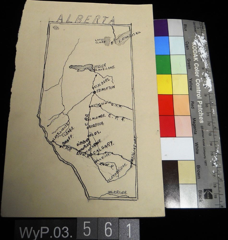
- Date
- 1917 – 1929
- Medium
- graphite; ink on paper
- Catalogue Number
- WyP.03.561
- Description
- Ink and pencil drawing of a map of Alberta with lakes, rivers, CPR lines and urban centres labeled. the border is delineated by a double line. ALBERTA is written above the northern border in narrow block letters.
1 image
- Title
- Untitled
- Date
- 1917 – 1929
- Medium
- graphite; ink on paper
- Dimensions
- 22.5 x 15.1 cm
- Description
- Ink and pencil drawing of a map of Alberta with lakes, rivers, CPR lines and urban centres labeled. the border is delineated by a double line. ALBERTA is written above the northern border in narrow block letters.
- Credit
- Gift of Catharine Robb Whyte, O. C., Banff, 1979
- Catalogue Number
- WyP.03.561
Images
This material is presented as originally created; it may contain outdated cultural descriptions and
potentially offensive content.
Read more.
Torpedo Car [on verso]
https://archives.whyte.org/en/permalink/artifactwyp.03.563
- Date
- 1917 – 1929
- Medium
- graphite on paper
- Catalogue Number
- WyP.03.563
- Description
- Drawings on both sides of the paper. Side 1 is a pencil drawing of a map of North America, including CANADA, US and MEXiCO all labeled.Verso is a pencil drawing of two figures in a car, facing left. Dust at tires and streak lines suggest speed. Titled in tlc as TORPEDO CAR
1 image
- Title
- Torpedo Car [on verso]
- Date
- 1917 – 1929
- Medium
- graphite on paper
- Dimensions
- 22.5 x 15.1 cm
- Description
- Drawings on both sides of the paper. Side 1 is a pencil drawing of a map of North America, including CANADA, US and MEXiCO all labeled.Verso is a pencil drawing of two figures in a car, facing left. Dust at tires and streak lines suggest speed. Titled in tlc as TORPEDO CAR
- Credit
- Gift of Catharine Robb Whyte, O. C., Banff, 1979
- Catalogue Number
- WyP.03.563
Images

This material is presented as originally created; it may contain outdated cultural descriptions and
potentially offensive content.
Read more.