Narrow Results By
Deep Powder and Steep Rock - textual
https://archives.whyte.org/en/permalink/descriptions55082
- Part Of
- Chic Scott fonds
- Scope & Content
- Series consists of textual records, including notes, manuscripts and other related materials, pertaining to the creation of the book "Deep Powder and Steep Rock".
- Date Range
- 2009
- Reference Code
- M57 / V
- Description Level
- 3 / Series
- GMD
- Textual record
- Map
- Part Of
- Chic Scott fonds
- Description Level
- 3 / Series
- Fonds Number
- M57 / V40 / S47
- Series
- M57 / V : Deep Powder and Steep Rock
- Sous-Fonds
- M57
- Accession Number
- 2014.8295
- 2015.8559
- Reference Code
- M57 / V
- GMD
- Textual record
- Map
- Date Range
- 2009
- Physical Description
- 30 cm of textual records
- History / Biographical
- Hans Gmoser played a major role in creating Canada’s vibrant mountain community. Although known internationally as the father of heli-skiing, he was much more than that: a talented rock climber, tireless expedition leader, a mountain guide, film maker and organizer. Deep Powder and Steep Rock presents an intimate portrait of this charismatic man. Much of the story is told in Gmoser’s own words, gleaned from his diaries, expedition journals, film commentaries and personal correspondence. It is a unique tale of adventure, hard work, perseverance and ultimate success.
- Scope & Content
- Series consists of textual records, including notes, manuscripts and other related materials, pertaining to the creation of the book "Deep Powder and Steep Rock".
- Notes
- Series consists of five sub-series: M57 / V / A: Research files M57 / V / B: Maps M57 / V / C: Interviews M57 / V / D: Photograph notes M57 / V / E: Draft Manuscript
- Name Access
- Scott, Chic
- Gmoser, Hans
- Subject Access
- Biography
- Personal and Professional Life
- Publication
- Research
- Geography
- Map
- Mountaineers
- Mountaineering
- Skiing
- Sports
- Recreation
- Winter sports
- Canadian Mountain Holidays
- Helicopter skiing
- Tourism
- Climbing
- Geographic Access
- Canada
- Alberta
- Banff
- Banff National Park
- Canadian Rocky Mountains
- Language
- English
- Related Material
- S47 / V
- V40 / V
- Biographical Source Notes
- http://chicscott.com/books.htm
- Title Source
- Title based on contents of file
- Processing Status
- Processed
This material is presented as originally created; it may contain outdated cultural descriptions and
potentially offensive content.
Read more.
Author's copy of Geology Road Tours
https://archives.whyte.org/en/permalink/descriptions56293
- Part Of
- Ben Gadd fonds
- Scope & Content
- File consists of one author's copy of Ben Gadd's book, Geology Road Tours, which includes corrections and other annotations by the author.
- Date Range
- 2008
- Reference Code
- M590 / II / B / 59
- Description Level
- 5 / File
- GMD
- Textual record
- Published record
- Part Of
- Ben Gadd fonds
- Description Level
- 5 / File
- Fonds Number
- M590
- V810
- S61
- Series
- M590 / II : Research and publication records
- Sous-Fonds
- M590
- Sub-Series
- M590 / II / B : Other publications
- Accession Number
- 2021.20
- Reference Code
- M590 / II / B / 59
- Responsibility
- Produced by Ben Gadd, Corax Press
- Date Range
- 2008
- Physical Description
- 3.5 cm of textual records : 1 volume ; 15.5 x 23 cm
- Scope & Content
- File consists of one author's copy of Ben Gadd's book, Geology Road Tours, which includes corrections and other annotations by the author.
- Name Access
- Gadd, Ben
- Subject Access
- Publication
- Commercial products
- Environment
- Geology
- Science and technology
- Geography
- Natural history
- Travel
- Roads
- Map
- Geographic Access
- Canada
- Alberta
- British Columbia
- Canadian Rocky Mountains
- Reproduction Restrictions
- Copyright restrictions may apply
- Language
- English
- Title Source
- Title based on contents of file
- Processing Status
- Processed
This material is presented as originally created; it may contain outdated cultural descriptions and
potentially offensive content.
Read more.
Jasper Trails Project - trail signage
https://archives.whyte.org/en/permalink/descriptions56127
- Part Of
- Ben Gadd fonds
- Scope & Content
- File consists of one letter to Ben Gadd from the Jasper-Yellowhead Historical Society Museum and Archives thanking him for his donation of trail signs from the Jasper Trails Project in 2005; and one page with notes [possibly written by Ben Gadd] pertaining to the previous locations of the trail sig…
- Date Range
- 2005
- Reference Code
- M590 / III / D / 100
- Description Level
- 5 / File
- GMD
- Textual record
- Part Of
- Ben Gadd fonds
- Description Level
- 5 / File
- Fonds Number
- M590
- V810
- S61
- Series
- M590 / III : Published records
- Sous-Fonds
- M590
- Sub-Series
- M590 / III / D : Other contracts and projects
- Accession Number
- 2021.20
- Reference Code
- M590 / III / D / 100
- GMD
- Textual record
- Date Range
- 2005
- Physical Description
- 0.1 cm of textual records
- Scope & Content
- File consists of one letter to Ben Gadd from the Jasper-Yellowhead Historical Society Museum and Archives thanking him for his donation of trail signs from the Jasper Trails Project in 2005; and one page with notes [possibly written by Ben Gadd] pertaining to the previous locations of the trail signs.
- Name Access
- Gadd, Ben
- Subject Access
- Publication
- Correspondence
- Organization
- Trails
- Research
- Map
- Environment
- Hiking
- Recreation
- Museums
- Geographic Access
- Canada
- Alberta
- Jasper
- Reproduction Restrictions
- Restrictions may apply
- Language
- English
- Title Source
- Title based on contents of file
- Processing Status
- Processed
This material is presented as originally created; it may contain outdated cultural descriptions and
potentially offensive content.
Read more.
Jasper Trails Project 1997
https://archives.whyte.org/en/permalink/descriptions56126
- Part Of
- Ben Gadd fonds
- Scope & Content
- File consists of one binder containing a report on the 1997 Jasper Trails Project, which was arranged by Ben Gadd and the Friends of Jasper National Park on behalf of Parks Canada. Report includes reference materials, project summaries and printed samples of maps.
- Date Range
- 1997
- Reference Code
- M590 / III / D / 99
- Description Level
- 5 / File
- GMD
- Textual record
- Part Of
- Ben Gadd fonds
- Description Level
- 5 / File
- Fonds Number
- M590
- V810
- S61
- Series
- M590 / III : Published records
- Sous-Fonds
- M590
- Sub-Series
- M590 / III / D : Other contracts and projects
- Accession Number
- 2021.20
- Reference Code
- M590 / III / D / 99
- GMD
- Textual record
- Date Range
- 1997
- Physical Description
- 2 cm of textual records (1 volume)
- Scope & Content
- File consists of one binder containing a report on the 1997 Jasper Trails Project, which was arranged by Ben Gadd and the Friends of Jasper National Park on behalf of Parks Canada. Report includes reference materials, project summaries and printed samples of maps.
- Name Access
- Gadd, Ben
- Subject Access
- Publication
- Correspondence
- Organization
- Trails
- Research
- Map
- Environment
- Hiking
- Recreation
- Government
- Parks Canada
- Geographic Access
- Canada
- Alberta
- Jasper
- Reproduction Restrictions
- Restrictions may apply
- Language
- English
- Title Source
- Title based on contents of file
- Processing Status
- Processed
This material is presented as originally created; it may contain outdated cultural descriptions and
potentially offensive content.
Read more.
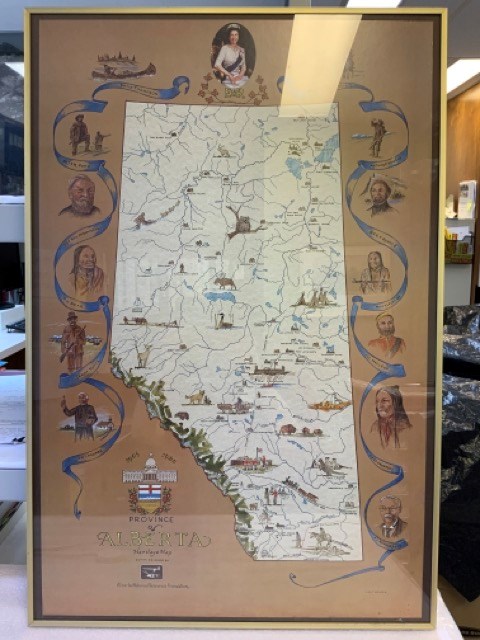
Province of Alberta Heritage Map
https://archives.whyte.org/en/permalink/artifacttuj.04.01
- Date
- 1980
- Medium
- print on paper
- Catalogue Number
- TuJ.04.01
- Description
- Off-white coloured map of alberta with blue bodies of water, green mppuntain rangte, and coloured drawings of animals, points of interest, and people. Brown background around map with blue ribbons and portraits of significant people, including Queen Elizabeth II at top. The Alberta coat of arms is …
1 image
- Title
- Province of Alberta Heritage Map
- Date
- 1980
- Medium
- print on paper
- Dimensions
- 91.0 x 96.0 cm
- Description
- Off-white coloured map of alberta with blue bodies of water, green mppuntain rangte, and coloured drawings of animals, points of interest, and people. Brown background around map with blue ribbons and portraits of significant people, including Queen Elizabeth II at top. The Alberta coat of arms is at bottom left with “1905” “1980” “PROVINCE OF ALBERTA HERITAGE MAP COMMISSIONED BY Alberta Historical Resources Foundation” Signed J.D. TURNER bottom right. In thin brass frame with glass.
- Credit
- Gift of John Davenall Turner (Estate), 2020
- Catalogue Number
- TuJ.04.01
Images
This material is presented as originally created; it may contain outdated cultural descriptions and
potentially offensive content.
Read more.
- Date
- 1954
- Medium
- graphite; ink on paper
- Catalogue Number
- WyP.03.952 p
- Description
- Left: blue ink map drawing “300 yds” Right: in pencil person sitting on stool wearing hate holding paintbrush facing away from viewer.Verso: drawings of person holding paintbrush facing away from viewer. Math equations. Type written: “Banff Alberta. Sunday Sept. 19, 1954 Dear Dorothy, How awfully”
1 image
- Title
- Untitled
- Date
- 1954
- Medium
- graphite; ink on paper
- Dimensions
- 16.5 x 25.0 cm
- Description
- Left: blue ink map drawing “300 yds” Right: in pencil person sitting on stool wearing hate holding paintbrush facing away from viewer.Verso: drawings of person holding paintbrush facing away from viewer. Math equations. Type written: “Banff Alberta. Sunday Sept. 19, 1954 Dear Dorothy, How awfully”
- Credit
- Gift of Catharine Robb Whyte, O. C., Banff, 1975
- Catalogue Number
- WyP.03.952 p
Images

This material is presented as originally created; it may contain outdated cultural descriptions and
potentially offensive content.
Read more.
- Part Of
- Malcolm Geddes fonds
- Scope & Content
- File consists of two lantern slide photographs of western and eastern Canadian national parks maps.
- Date Range
- [ca.1925]
- Reference Code
- V756 / III / A / PS - 231 and 232
- Description Level
- 5 / File
- GMD
- Photograph
- Lantern slide
- Map
- Part Of
- Malcolm Geddes fonds
- Description Level
- 5 / File
- Fonds Number
- M39
- V756
- Series
- V756 / III : Personal and family records
- Sous-Fonds
- V756
- Sub-Series
- V756 / III / A : Travel and mountain expeditions
- Accession Number
- 6504
- Reference Code
- V756 / III / A / PS - 231 and 232
- Date Range
- [ca.1925]
- Physical Description
- 2 photographs : lantern slides
- Scope & Content
- File consists of two lantern slide photographs of western and eastern Canadian national parks maps.
- Material Details
- Lantern slides are hand-coloured
- Subject Access
- Map
- Geography
- National parks and reserves
- Travel
- Geographic Access
- Canada
- Access Restrictions
- Fragile - restrictions may apply
- Language
- N/A
- Category
- Exploration, discovery and travel
- Title Source
- Title based on contents of file
- Processing Status
- Processed
This material is presented as originally created; it may contain outdated cultural descriptions and
potentially offensive content.
Read more.
Rocky Mountains Park topographical map
https://archives.whyte.org/en/permalink/descriptions55707
- Part Of
- Luxton family fonds
- Scope & Content
- File consists of one printed map on canvas depicting Rocky Mountains Park and surrounding areas, ca.1910-1930. Map is annotated with red hand-coloured markers and small notes written in black ink.
- Date Range
- [ca.1910-1930]
- Reference Code
- LUX / III / D / 38 (oversize)
- Description Level
- 5 / File
- GMD
- Map
- Part Of
- Luxton family fonds
- Description Level
- 5 / File
- Fonds Number
- LUX
- Series
- LUX / III / D : Other material
- Sous-Fonds
- LUX / III : Luxton family sous-fonds
- Accession Number
- LUX
- Reference Code
- LUX / III / D / 38 (oversize)
- GMD
- Map
- Date Range
- [ca.1910-1930]
- Physical Description
- 1 topographical map : hand col., annotations, on canvas ; 150 x 100 cm
- History / Biographical
- Rocky Mountains Park was renamed Banff National Park on May 30, 1930 as part of the National Parks Act passed by the Government of Canada.
- Scope & Content
- File consists of one printed map on canvas depicting Rocky Mountains Park and surrounding areas, ca.1910-1930. Map is annotated with red hand-coloured markers and small notes written in black ink.
- Notes
- Context of map mostly unknown. Missing title, date and other identifying information.
- Subject Access
- Map
- Geography
- Landscapes
- Parks
- Geographic Access
- Canada
- Alberta
- Canadian Rocky Mountains
- Access Restrictions
- Map is difficult to handle due to size and condition. Assistance from archival staff required for physical access
- Language
- English
- Conservation
- Use nitrile gloves while handling map
- Biographical Source Notes
- http://parkscanadahistory.com/publications/national-parks-act-1930.htm
- Title Source
- Title based on contents of file
- Processing Status
- Processed
This material is presented as originally created; it may contain outdated cultural descriptions and
potentially offensive content.
Read more.
Personal Interest Files - "Parks Canada Reorganization" to "Rocky Mountain Youth Initiative"
https://archives.whyte.org/en/permalink/descriptions55808
- Part Of
- Ben Gadd fonds
- Scope & Content
- File consists of personal interest materials, including newspaper clippings, research articles, loose notes, and other textual records collected by Ben Gadd. Materials are arranged alphabetically by subject title.
- Date Range
- [ca.1980-2015]
- Reference Code
- M590 / I / C / 127 to 143
- Description Level
- 5 / File
- GMD
- Textual record
- Published record
- Newspaper clipping
- Part Of
- Ben Gadd fonds
- Description Level
- 5 / File
- Fonds Number
- M590
- V810
- S61
- Series
- M590 / I : Personal records
- Sous-Fonds
- M590
- Sub-Series
- M590 / I / C : Personal Interest Files
- Accession Number
- 2021.20
- Reference Code
- M590 / I / C / 127 to 143
- Responsibility
- Compiled by Ben Gadd
- Date Range
- [ca.1980-2015]
- Physical Description
- 12 cm of textual records
- Scope & Content
- File consists of personal interest materials, including newspaper clippings, research articles, loose notes, and other textual records collected by Ben Gadd. Materials are arranged alphabetically by subject title.
- Notes
- Contents of individual folders in file: M590 / I / C / 127 to 128 : Parks Canada Reorganization [Files 1 and 2 of 2] M590 / I / C / 129 : Pipeline (Trans Canada, etc.) M590 / I / C / 130 : Plans M590 / I / C / 131 : Pocahontas (Maps, Plans) M590 / I / C / 132 : Pole, Graeme M590 / I / C / 133 : Poisons, Pesticides, Pollution M590 / I / C / 134 : Population Explosion M590 / I / C / 135 : Provincial Parks M590 / I / C / 136 : Railways M590 / I / C / 137 : Rapson, Dwight M590 / I / C / 138 : RCMP M590 / I / C / 139 : Resorts, Industrial Tourism M590 / I / C / 140 : Roy Richards M590 / I / C / 141 : Rivers, Flooding M590 / I / C / 142 : Roads + Highways, Salting M590 / I / C / 143 : Rocky Mountain Youth Initiative
- Name Access
- Gadd, Ben
- Subject Access
- Tourism
- National parks and reserves
- Government
- Travel
- Transportation
- Trains
- Railways
- Royal Canadian Mounted Police
- Rivers
- Provincial parks and reserves
- Pollution
- Oil
- Natural resources
- Roads
- Map
- Geography
- Geographic Access
- Canada
- Alberta
- Jasper National Park
- Reproduction Restrictions
- Restrictions may apply
- Language
- English
- Category
- Environment
- Natural resources
- Government
- Title Source
- Original title used
- Processing Status
- Processed
This material is presented as originally created; it may contain outdated cultural descriptions and
potentially offensive content.
Read more.
Jasper National Park geology book project
https://archives.whyte.org/en/permalink/descriptions55814
- Part Of
- Ben Gadd fonds
- Scope & Content
- File consists of notes, correspondence and invoices pertaining to the creation and publication of a guidebook titled "Of Rocks, Mountains and Jasper" by Dr. Chris Yorath and Ben Gadd. Includes correspondence and invoices regarding copyright permissions and payment for the use of 35 original photogr…
- Date Range
- 1993-1995
- Reference Code
- M590 / II / B / 25
- Description Level
- 5 / File
- GMD
- Textual record
- Part Of
- Ben Gadd fonds
- Description Level
- 5 / File
- Fonds Number
- M590
- S61
- V810
- Series
- M590 / II : Research and Publication Records
- Sous-Fonds
- M590
- Sub-Series
- M590 / II / B : Other Publications
- Accession Number
- 2021.20
- Reference Code
- M590 / II / B / 25
- GMD
- Textual record
- Responsibility
- Produced by Ben Gadd and Chris Yorath
- Date Range
- 1993-1995
- Physical Description
- 2 cm of textual records
- Scope & Content
- File consists of notes, correspondence and invoices pertaining to the creation and publication of a guidebook titled "Of Rocks, Mountains and Jasper" by Dr. Chris Yorath and Ben Gadd. Includes correspondence and invoices regarding copyright permissions and payment for the use of 35 original photographs by Ben Gadd; drafts of maps and illustrations used in the book; and other related content.
- Name Access
- Gadd, Ben
- Yorath, Chris
- Subject Access
- Research
- Publication
- Geology
- Geography
- Map
- National parks and reserves
- Natural history
- Environment
- Finances
- Travel
- Tourism
- Tourist information
- Geographic Access
- Canada
- Alberta
- Jasper
- Jasper National Park
- Reproduction Restrictions
- Copyright restrictions may apply
- Language
- English
- Title Source
- Title based on contents of file
- Processing Status
- Processed
This material is presented as originally created; it may contain outdated cultural descriptions and
potentially offensive content.
Read more.