Narrow Results By
- Date
- 1954
- Medium
- graphite; ink on paper
- Catalogue Number
- WyP.03.952 p
- Description
- Left: blue ink map drawing “300 yds” Right: in pencil person sitting on stool wearing hate holding paintbrush facing away from viewer.Verso: drawings of person holding paintbrush facing away from viewer. Math equations. Type written: “Banff Alberta. Sunday Sept. 19, 1954 Dear Dorothy, How awfully”
1 image
- Title
- Untitled
- Date
- 1954
- Medium
- graphite; ink on paper
- Dimensions
- 16.5 x 25.0 cm
- Description
- Left: blue ink map drawing “300 yds” Right: in pencil person sitting on stool wearing hate holding paintbrush facing away from viewer.Verso: drawings of person holding paintbrush facing away from viewer. Math equations. Type written: “Banff Alberta. Sunday Sept. 19, 1954 Dear Dorothy, How awfully”
- Credit
- Gift of Catharine Robb Whyte, O. C., Banff, 1975
- Catalogue Number
- WyP.03.952 p
Images

This material is presented as originally created; it may contain outdated cultural descriptions and
potentially offensive content.
Read more.
- Date
- 1917 – 1966
- Medium
- ink on paper
- Catalogue Number
- WyP.03.513
- Description
- A detailed ink drawing of a map South America, in a double-rectangle border.
1 image
- Title
- South America
- Date
- 1917 – 1966
- Medium
- ink on paper
- Dimensions
- 23.5 x 15.1 cm
- Description
- A detailed ink drawing of a map South America, in a double-rectangle border.
- Subject
- South America
- map
- Credit
- Gift of Catharine Robb Whyte, O. C., Banff, 1975
- Catalogue Number
- WyP.03.513
Images

This material is presented as originally created; it may contain outdated cultural descriptions and
potentially offensive content.
Read more.
The Great Lakes and the States that Bound Them
https://archives.whyte.org/en/permalink/artifactwyp.03.514
- Date
- 1917 – 1966
- Medium
- ink on paper
- Catalogue Number
- WyP.03.514
- Description
- Ink drawing of a geographic perspective of the Great Lakes region, including the states that border on Canada
1 image
- Title
- The Great Lakes and the States that Bound Them
- Date
- 1917 – 1966
- Medium
- ink on paper
- Dimensions
- 15.1 x 22.5 cm
- Description
- Ink drawing of a geographic perspective of the Great Lakes region, including the states that border on Canada
- Subject
- map
- Great Lakes
- Canada
- United States
- geography
- Credit
- Gift of Catharine Robb Whyte, O. C., Banff, 1975
- Catalogue Number
- WyP.03.514
Images

This material is presented as originally created; it may contain outdated cultural descriptions and
potentially offensive content.
Read more.
- Date
- 1917 – 1966
- Medium
- ink on drawing
- Catalogue Number
- WyP.03.515
- Description
- An ink drawing of a map of Saskatchewan on paper. Labelled SASKATEWAN [sic] in centre, written vertically towards the top edge.
1 image
- Title
- Untitled
- Date
- 1917 – 1966
- Medium
- ink on drawing
- Dimensions
- 22.5 x 15.1 cm
- Description
- An ink drawing of a map of Saskatchewan on paper. Labelled SASKATEWAN [sic] in centre, written vertically towards the top edge.
- Subject
- map
- Saskatchewan
- province
- Canada
- geography
- Credit
- Gift of Catharine Robb Whyte, O. C., Banff, 1975
- Catalogue Number
- WyP.03.515
Images

This material is presented as originally created; it may contain outdated cultural descriptions and
potentially offensive content.
Read more.
- Date
- n.d.
- Medium
- graphite; ink on paper
- Catalogue Number
- WyP.03.549
- Description
- An ink and pencil drawing of Quebec, New Brunswick, Ontario and Manitoba, from a cartographical perspective.
1 image
- Title
- Map of Quebec
- Date
- n.d.
- Medium
- graphite; ink on paper
- Dimensions
- 22.5 x 15.1 cm
- Description
- An ink and pencil drawing of Quebec, New Brunswick, Ontario and Manitoba, from a cartographical perspective.
- Subject
- map
- cartography
- Ontario
- Manitoba
- New Brunswick
- Quebec
- Credit
- Gift of Catharine Robb Whyte, O. C., Banff, 1979
- Catalogue Number
- WyP.03.549
Images

This material is presented as originally created; it may contain outdated cultural descriptions and
potentially offensive content.
Read more.
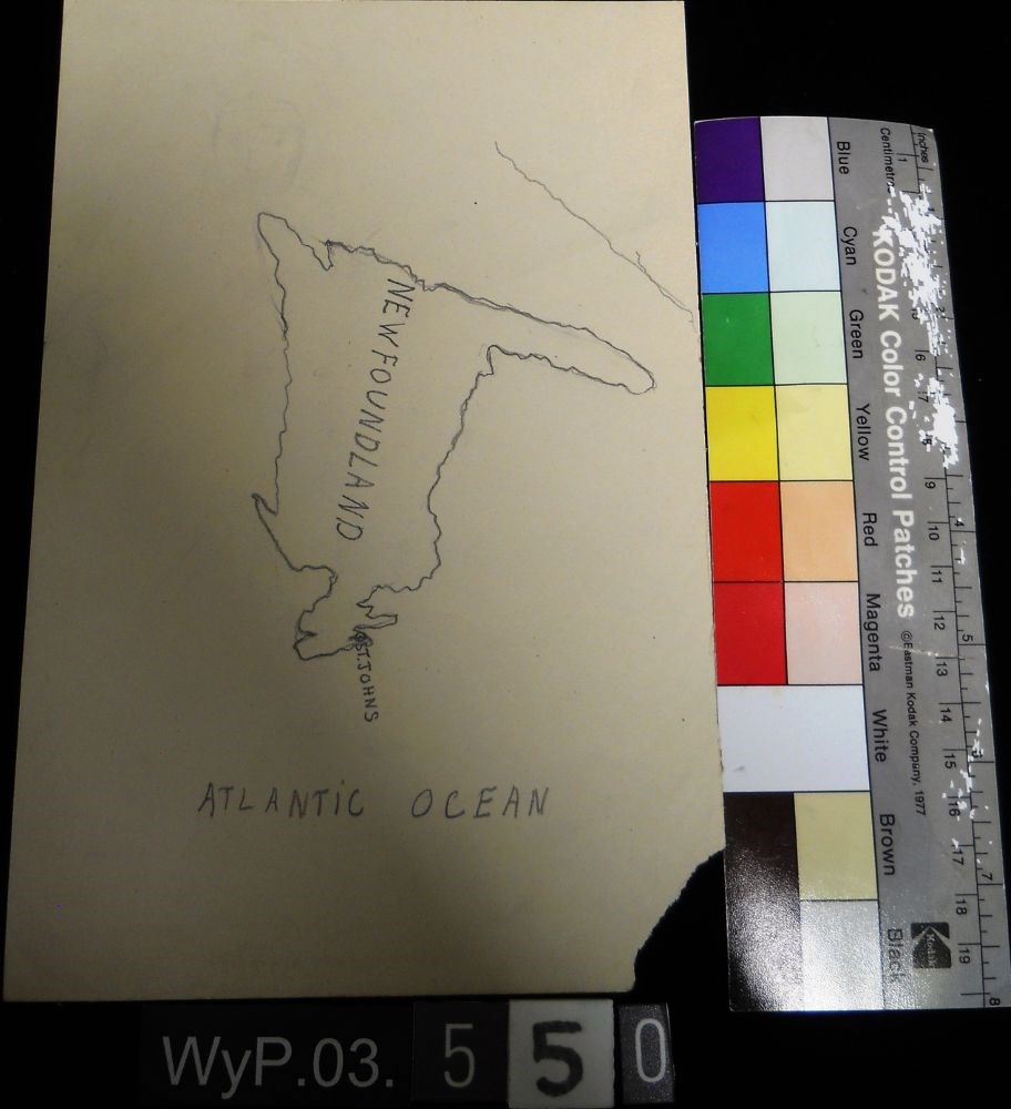
Map of Newfoundland
https://archives.whyte.org/en/permalink/artifactwyp.03.550
- Date
- n.d.
- Medium
- graphite on paper
- Catalogue Number
- WyP.03.550
- Description
- A pencil drawn map of Newfoundland, including the Atlantic Ocean.
1 image
- Title
- Map of Newfoundland
- Date
- n.d.
- Medium
- graphite on paper
- Dimensions
- 22.5 x 15.1 cm
- Description
- A pencil drawn map of Newfoundland, including the Atlantic Ocean.
- Subject
- map
- cartography
- Newfoundland
- Atlantic Ocean
- Credit
- Gift of Catharine Robb Whyte, O. C., Banff, 1979
- Catalogue Number
- WyP.03.550
Images
This material is presented as originally created; it may contain outdated cultural descriptions and
potentially offensive content.
Read more.
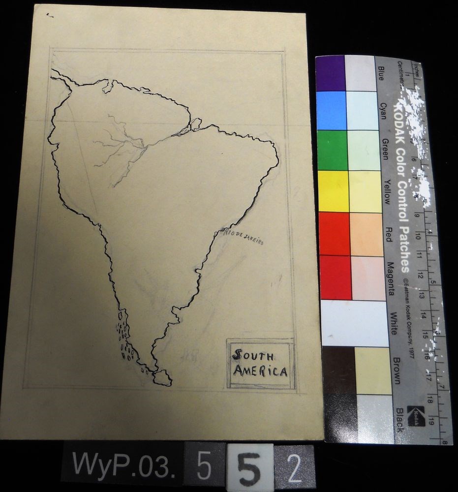
- Date
- n.d.
- Medium
- graphite; ink on paper
- Catalogue Number
- WyP.03.552
- Description
- A pencil and ink drawing of a map of South America. Rio de Janeiro is labeled on right edge of the continent.
1 image
- Title
- Untitled
- Date
- n.d.
- Medium
- graphite; ink on paper
- Dimensions
- 22.5 x 15.1 cm
- Description
- A pencil and ink drawing of a map of South America. Rio de Janeiro is labeled on right edge of the continent.
- Subject
- South America
- Rio de Janeiro
- map
- cartography
- Credit
- Gift of Catharine Robb Whyte, O. C., Banff, 1979
- Catalogue Number
- WyP.03.552
Images
This material is presented as originally created; it may contain outdated cultural descriptions and
potentially offensive content.
Read more.
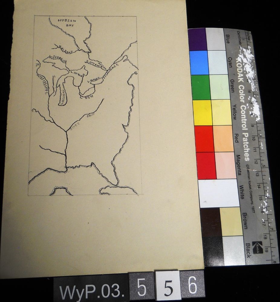
- Date
- 1917 – 1929
- Medium
- graphite; ink on paper
- Catalogue Number
- WyP.03.556
- Description
- A pencil and ink drawing of a map of Hudson Bay and the river system in eastern Canada and United States. Includes Great Lakes as well. Bodies of water are labeled.
1 image
- Title
- Untitled
- Date
- 1917 – 1929
- Medium
- graphite; ink on paper
- Dimensions
- 22.5 x 15.1 cm
- Description
- A pencil and ink drawing of a map of Hudson Bay and the river system in eastern Canada and United States. Includes Great Lakes as well. Bodies of water are labeled.
- Subject
- Canada
- Hudson Bay
- rivers
- United States
- U.S.A.
- map
- Credit
- Gift of Catharine Robb Whyte, O. C., Banff, 1979
- Catalogue Number
- WyP.03.556
Images
This material is presented as originally created; it may contain outdated cultural descriptions and
potentially offensive content.
Read more.
Map of Ontario
https://archives.whyte.org/en/permalink/artifactwyp.03.559
- Date
- 1917 – 1929
- Medium
- graphite; ink on paper
- Catalogue Number
- WyP.03.559
- Description
- Pencil and ink drawing of Ontario, the Manitoba border, and Great Lakes with rivers and urban centres labeled.title: MAP OF ONTARIO [top left, surrounded by short marks]
1 image
- Title
- Map of Ontario
- Date
- 1917 – 1929
- Medium
- graphite; ink on paper
- Dimensions
- 15.1 x 22.5 cm
- Description
- Pencil and ink drawing of Ontario, the Manitoba border, and Great Lakes with rivers and urban centres labeled.title: MAP OF ONTARIO [top left, surrounded by short marks]
- Credit
- Gift of Catharine Robb Whyte, O. C., Banff, 1979
- Catalogue Number
- WyP.03.559
Images

This material is presented as originally created; it may contain outdated cultural descriptions and
potentially offensive content.
Read more.
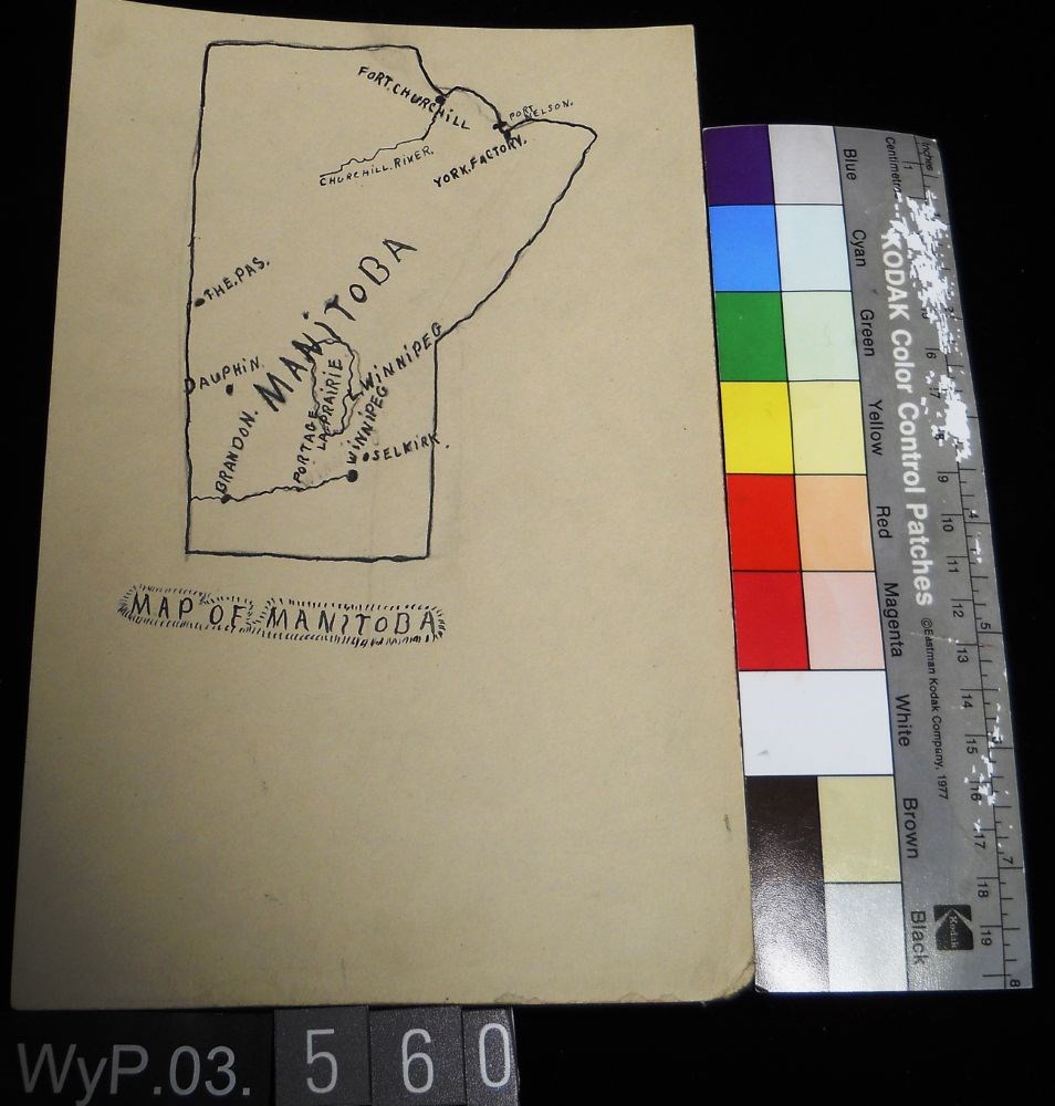
Map of Manitoba
https://archives.whyte.org/en/permalink/artifactwyp.03.560
- Date
- 1917 – 1929
- Medium
- ink; graphite on paper
- Catalogue Number
- WyP.03.560
- Description
- Pencil and ink drawing of a map of Manitoba with rivers, lakes and urban centres labeled. [Below drawing, surrounded by circle of short marks] MAP of MANITOBA
1 image
- Title
- Map of Manitoba
- Date
- 1917 – 1929
- Medium
- ink; graphite on paper
- Dimensions
- 22.5 x 15.1 cm
- Description
- Pencil and ink drawing of a map of Manitoba with rivers, lakes and urban centres labeled. [Below drawing, surrounded by circle of short marks] MAP of MANITOBA
- Credit
- Gift of Catharine Robb Whyte, O. C., Banff, 1979
- Catalogue Number
- WyP.03.560
Images
This material is presented as originally created; it may contain outdated cultural descriptions and
potentially offensive content.
Read more.