Narrow Results By
Plan of Banff, Rocky Mountains Park, Alberta
https://archives.whyte.org/en/permalink/catalogue23256
- Medium
- Library - Maps and blueprints (unannotated; published)
- Map
- Published Date
- 1981
- Publisher
- Dept. of the Interior, Canada
- Call Number
- C4-1.3a
- Responsibility
- Ottawa: Association of Canadian Map Libraries in cooperation with Iain C. Taylor
- Publisher
- Dept. of the Interior, Canada
- Published Date
- 1981
- Physical Description
- 1 map : black and white
- Scale
- Scale: 1 inch = 400 feet
- Notes
- Facsimile/Association of Canadian Map Libraries; no. 29
- Reproduced from original in National Map Collection, Public Archives Canada (ca 1917)
- 1920. Limited edition, Copy 452
- Accession Number
- 3465
- 6073
- Call Number
- C4-1.3a
- Collection
- Archives Library
This material is presented as originally created; it may contain outdated cultural descriptions and
potentially offensive content.
Read more.
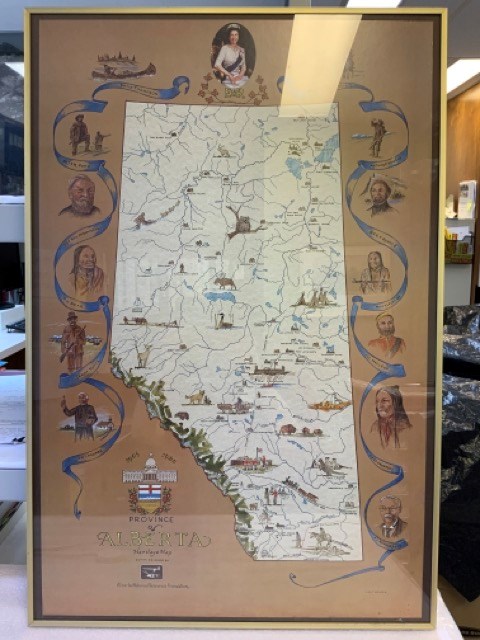
Province of Alberta Heritage Map
https://archives.whyte.org/en/permalink/artifacttuj.04.01
- Date
- 1980
- Medium
- print on paper
- Catalogue Number
- TuJ.04.01
- Description
- Off-white coloured map of alberta with blue bodies of water, green mppuntain rangte, and coloured drawings of animals, points of interest, and people. Brown background around map with blue ribbons and portraits of significant people, including Queen Elizabeth II at top. The Alberta coat of arms is …
1 image
- Title
- Province of Alberta Heritage Map
- Date
- 1980
- Medium
- print on paper
- Dimensions
- 91.0 x 96.0 cm
- Description
- Off-white coloured map of alberta with blue bodies of water, green mppuntain rangte, and coloured drawings of animals, points of interest, and people. Brown background around map with blue ribbons and portraits of significant people, including Queen Elizabeth II at top. The Alberta coat of arms is at bottom left with “1905” “1980” “PROVINCE OF ALBERTA HERITAGE MAP COMMISSIONED BY Alberta Historical Resources Foundation” Signed J.D. TURNER bottom right. In thin brass frame with glass.
- Credit
- Gift of John Davenall Turner (Estate), 2020
- Catalogue Number
- TuJ.04.01
Images
This material is presented as originally created; it may contain outdated cultural descriptions and
potentially offensive content.
Read more.
[Alberta-Base Map]
https://archives.whyte.org/en/permalink/catalogue24392
- Medium
- Library - Maps and blueprints (unannotated; published)
- Map
- Published Date
- 1976
- Call Number
- C9-1.6(d)
- Published Date
- 1976
- Scale
- Scale: 1':50 miles
- Subjects
- [Alberta-Base Map]
- Accession Number
- SG 9000
- Call Number
- C9-1.6(d)
- Collection
- Archives Library
This material is presented as originally created; it may contain outdated cultural descriptions and
potentially offensive content.
Read more.
[Alberta-Base Map]
https://archives.whyte.org/en/permalink/catalogue24391
- Medium
- Library - Maps and blueprints (unannotated; published)
- Map
- Published Date
- 1975
- Publisher
- Surveys Branch, Alberta Transp.
- Call Number
- C9-1.6(c)
- Publisher
- Surveys Branch, Alberta Transp.
- Published Date
- 1975
- Physical Description
- 1 map : black, white, blue
- Scale
- Scale: 1":40 miles
- Subjects
- Alberta-Base Map
- Accession Number
- SG 9000
- Call Number
- C9-1.6(c)
- Collection
- Archives Library
This material is presented as originally created; it may contain outdated cultural descriptions and
potentially offensive content.
Read more.
Reference Index-Canada 1972
https://archives.whyte.org/en/permalink/catalogue23318
- Medium
- Library - Maps and blueprints (unannotated; published)
- Map
- Published Date
- 1973
- Publisher
- Inland Waters Directorate of the Environment, Water Resources
- Call Number
- C5-5.6
- C5-5.6a
- C5-5.6b
- C5-5.6c
- C5-5.6d
- C5-5.6e
- C5-5.6f
- C5-5.6g
- C5-5.6h
- C5-5.6i
- C5-5.6j
- C5-5.6k
- Publisher
- Inland Waters Directorate of the Environment, Water Resources
- Published Date
- 1973
- Scale
- 1" - 32 miles
- Subjects
- Hydrometric Map Supplement
- Notes
- Maps: Atlantic Provinces-Discontinued Hydrometric Stations, Ontario, Prairie Provinces, Brtisih Columbia, Yukon N.W.T. Atlantic Provinces
- Accession Number
- 6500
- Call Number
- C5-5.6
- C5-5.6a
- C5-5.6b
- C5-5.6c
- C5-5.6d
- C5-5.6e
- C5-5.6f
- C5-5.6g
- C5-5.6h
- C5-5.6i
- C5-5.6j
- C5-5.6k
- Collection
- Archives Library
This material is presented as originally created; it may contain outdated cultural descriptions and
potentially offensive content.
Read more.
[Alberta-Base Map]
https://archives.whyte.org/en/permalink/catalogue24389
- Medium
- Library - Maps and blueprints (unannotated; published)
- Map
- Published Date
- 1972
- Publisher
- Surveys Branch, Dept. of Highways and Transport
- Call Number
- C9-1.6(a)
- Publisher
- Surveys Branch, Dept. of Highways and Transport
- Published Date
- 1972
- Physical Description
- 1 map : black and white
- Scale
- Scale: 1":50 miles
- Subjects
- Alberta-Base Map
- Accession Number
- SG7500
- Call Number
- C9-1.6(a)
- Collection
- Archives Library
This material is presented as originally created; it may contain outdated cultural descriptions and
potentially offensive content.
Read more.
[Alberta Air Facilities Map]
https://archives.whyte.org/en/permalink/catalogue24802
- Medium
- Library - Maps and blueprints (unannotated; published)
- Map
- Published Date
- 1970
- Publisher
- Department of Lands and Forests
- Call Number
- C12-4.19
- Publisher
- Department of Lands and Forests
- Published Date
- 1970
- Scale
- 1 inch = 16 miles
- Subjects
- Alberta Air Facilities Map
- Accession Number
- 2000
- Call Number
- C12-4.19
- Collection
- Archives Library
This material is presented as originally created; it may contain outdated cultural descriptions and
potentially offensive content.
Read more.
- Medium
- Library - Maps and blueprints (unannotated; published)
- Map
- Published Date
- 1968
- Publisher
- Glaciology Subdivision, Inland Waters Branch, Department of Energy, Mines and Resources, Ottawa, Canada
- Call Number
- C5-3.6
- Publisher
- Glaciology Subdivision, Inland Waters Branch, Department of Energy, Mines and Resources, Ottawa, Canada
- Published Date
- 1968
- Physical Description
- Coloured
- Scale
- 1:1,000,000
- Accession Number
- 7000
- Call Number
- C5-3.6
- Collection
- Archives Library
This material is presented as originally created; it may contain outdated cultural descriptions and
potentially offensive content.
Read more.
- Medium
- Library - Maps and blueprints (unannotated; published)
- Map
- Published Date
- 1968
- Publisher
- Glaciology Subdivision, Inland Waters Branch, Deparment of Energy, Mines and Resources
- Call Number
- C5-3.7
- Publisher
- Glaciology Subdivision, Inland Waters Branch, Deparment of Energy, Mines and Resources
- Published Date
- 1968
- Physical Description
- Coloured
- Scale
- 1:1,000,000
- Accession Number
- 7000
- Call Number
- C5-3.7
- Collection
- Archives Library
This material is presented as originally created; it may contain outdated cultural descriptions and
potentially offensive content.
Read more.
- Medium
- Library - Maps and blueprints (unannotated; published)
- Map
- Published Date
- 1968
- Publisher
- Glaciology Subdivison, Inland Waters Branch, Department of Energy, Mines and Resources
- Call Number
- C5-3.8
- Publisher
- Glaciology Subdivison, Inland Waters Branch, Department of Energy, Mines and Resources
- Published Date
- 1968
- Physical Description
- Coloured
- Scale
- 1:1,000,000
- Accession Number
- 7000
- Call Number
- C5-3.8
- Collection
- Archives Library
This material is presented as originally created; it may contain outdated cultural descriptions and
potentially offensive content.
Read more.