Narrow Results By
[Canada Railway map] Southeastern Canada
https://archives.whyte.org/en/permalink/catalogue24552
- Medium
- Library - Maps and blueprints (unannotated; published)
- Map
- Published Date
- 1930
- Call Number
- C11-3.1
- Published Date
- 1930
- Scale
- Scale: 100 miles - 1 inch
- Subjects
- Canada
- Railway map
- Notes
- Railway map showing CNR, CPR and other Railways, in operation and under construction in 1930
- Accession Number
- 400
- Call Number
- C11-3.1
- Collection
- Archives Library
This material is presented as originally created; it may contain outdated cultural descriptions and
potentially offensive content.
Read more.
The Great Lakes and the States that Bound Them
https://archives.whyte.org/en/permalink/artifactwyp.03.514
- Date
- 1917 – 1966
- Medium
- ink on paper
- Catalogue Number
- WyP.03.514
- Description
- Ink drawing of a geographic perspective of the Great Lakes region, including the states that border on Canada
1 image
- Title
- The Great Lakes and the States that Bound Them
- Date
- 1917 – 1966
- Medium
- ink on paper
- Dimensions
- 15.1 x 22.5 cm
- Description
- Ink drawing of a geographic perspective of the Great Lakes region, including the states that border on Canada
- Subject
- map
- Great Lakes
- Canada
- United States
- geography
- Credit
- Gift of Catharine Robb Whyte, O. C., Banff, 1975
- Catalogue Number
- WyP.03.514
Images

This material is presented as originally created; it may contain outdated cultural descriptions and
potentially offensive content.
Read more.
Hand drawn map of Windermere region, poem
https://archives.whyte.org/en/permalink/descriptions57577
- Part Of
- Archives General File Collection
- Scope & Content
- File consists of one hand-drawn map by Roger Ruck (1915-1953) depicting Windermere and surrounding regions. A poem pertaining to Roger's early life in England is written on the back.
- Date Range
- [ca.1935 - 1940]
- Reference Code
- M8 / accn. 2023.48
- Description Level
- 5 / File
- GMD
- Textual record
- Map
- Part Of
- Archives General File Collection
- Description Level
- 5 / File
- Fonds Number
- M8
- V8
- S8
- Sous-Fonds
- M8
- Accession Number
- 2023.48
- Reference Code
- M8 / accn. 2023.48
- GMD
- Textual record
- Map
- Responsibility
- Produced by Roger Ruck
- Date Range
- [ca.1935 - 1940]
- Physical Description
- 1 map : hand-drawn black ink ; 11 x 21 cm
- History / Biographical
- See V8 / accn. 2023.48 / PA - 1 to 5
- See accession record
- Scope & Content
- File consists of one hand-drawn map by Roger Ruck (1915-1953) depicting Windermere and surrounding regions. A poem pertaining to Roger's early life in England is written on the back.
- Material Details
- Map and poem drawn/written in black ink
- Name Access
- Ruck, Roger
- Subject Access
- Geography
- Map
- Poetry
- Exploration
- Travel
- Geographic Access
- Canada
- British Columbia
- Windermere
- Access Restrictions
- No restrictions
- Reproduction Restrictions
- No restrictions
- Language
- English
- Related Material
- V8 / accn. 2023.48 / PA - 1 to 5
- Category
- Exploration and travel
- Title Source
- Title based on contents of file
- Processing Status
- Processed
This material is presented as originally created; it may contain outdated cultural descriptions and
potentially offensive content.
Read more.
Map of Banff, Yoho and Kootenay Parks especially designed for the Trail Riders and the Skyline Hikers
https://archives.whyte.org/en/permalink/catalogue21346
- Medium
- Library - Maps and blueprints (unannotated; published)
- Map
- Published Date
- 1938 (approx.)
- Publisher
- Rand McNally & Co.
- Call Number
- C6-4.1(b)
- Publisher
- Rand McNally & Co.
- Published Date
- 1938 (approx.)
- Subjects
- Trail Riders Map
- Accession Number
- 540
- 5390
- Call Number
- C6-4.1(b)
- Collection
- Archives Library
This material is presented as originally created; it may contain outdated cultural descriptions and
potentially offensive content.
Read more.
Map of Banff, Yoho and Kootenay Parks especially designed for the Trail Riders and the Skyline Hikers
https://archives.whyte.org/en/permalink/catalogue21376
- Medium
- Library - Maps and blueprints (unannotated; published)
- Map
- Published Date
- 1938 (approx.)
- Publisher
- Rand McNally & Co.
- Call Number
- C6-4.1(b)
- Publisher
- Rand McNally & Co.
- Published Date
- 1938 (approx.)
- Subjects
- Trail Riders Map
- Accession Number
- 540
- 5390
- Call Number
- C6-4.1(b)
- Collection
- Archives Library
This material is presented as originally created; it may contain outdated cultural descriptions and
potentially offensive content.
Read more.
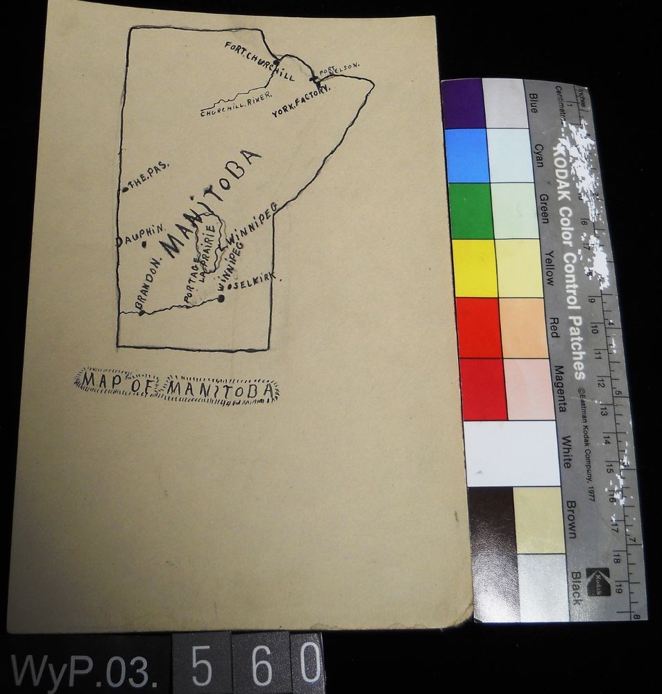
Map of Manitoba
https://archives.whyte.org/en/permalink/artifactwyp.03.560
- Date
- 1917 – 1929
- Medium
- ink; graphite on paper
- Catalogue Number
- WyP.03.560
- Description
- Pencil and ink drawing of a map of Manitoba with rivers, lakes and urban centres labeled. [Below drawing, surrounded by circle of short marks] MAP of MANITOBA
1 image
- Title
- Map of Manitoba
- Date
- 1917 – 1929
- Medium
- ink; graphite on paper
- Dimensions
- 22.5 x 15.1 cm
- Description
- Pencil and ink drawing of a map of Manitoba with rivers, lakes and urban centres labeled. [Below drawing, surrounded by circle of short marks] MAP of MANITOBA
- Credit
- Gift of Catharine Robb Whyte, O. C., Banff, 1979
- Catalogue Number
- WyP.03.560
Images
This material is presented as originally created; it may contain outdated cultural descriptions and
potentially offensive content.
Read more.
Map of Ontario
https://archives.whyte.org/en/permalink/artifactwyp.03.559
- Date
- 1917 – 1929
- Medium
- graphite; ink on paper
- Catalogue Number
- WyP.03.559
- Description
- Pencil and ink drawing of Ontario, the Manitoba border, and Great Lakes with rivers and urban centres labeled.title: MAP OF ONTARIO [top left, surrounded by short marks]
1 image
- Title
- Map of Ontario
- Date
- 1917 – 1929
- Medium
- graphite; ink on paper
- Dimensions
- 15.1 x 22.5 cm
- Description
- Pencil and ink drawing of Ontario, the Manitoba border, and Great Lakes with rivers and urban centres labeled.title: MAP OF ONTARIO [top left, surrounded by short marks]
- Credit
- Gift of Catharine Robb Whyte, O. C., Banff, 1979
- Catalogue Number
- WyP.03.559
Images

This material is presented as originally created; it may contain outdated cultural descriptions and
potentially offensive content.
Read more.
Rocky Mountains Park topographical map
https://archives.whyte.org/en/permalink/descriptions55707
- Part Of
- Luxton family fonds
- Scope & Content
- File consists of one printed map on canvas depicting Rocky Mountains Park and surrounding areas, ca.1910-1930. Map is annotated with red hand-coloured markers and small notes written in black ink.
- Date Range
- [ca.1910-1930]
- Reference Code
- LUX / III / D / 38 (oversize)
- Description Level
- 5 / File
- GMD
- Map
- Part Of
- Luxton family fonds
- Description Level
- 5 / File
- Fonds Number
- LUX
- Series
- LUX / III / D : Other material
- Sous-Fonds
- LUX / III : Luxton family sous-fonds
- Accession Number
- LUX
- Reference Code
- LUX / III / D / 38 (oversize)
- GMD
- Map
- Date Range
- [ca.1910-1930]
- Physical Description
- 1 topographical map : hand col., annotations, on canvas ; 150 x 100 cm
- History / Biographical
- Rocky Mountains Park was renamed Banff National Park on May 30, 1930 as part of the National Parks Act passed by the Government of Canada.
- Scope & Content
- File consists of one printed map on canvas depicting Rocky Mountains Park and surrounding areas, ca.1910-1930. Map is annotated with red hand-coloured markers and small notes written in black ink.
- Notes
- Context of map mostly unknown. Missing title, date and other identifying information.
- Subject Access
- Map
- Geography
- Landscapes
- Parks
- Geographic Access
- Canada
- Alberta
- Canadian Rocky Mountains
- Access Restrictions
- Map is difficult to handle due to size and condition. Assistance from archival staff required for physical access
- Language
- English
- Conservation
- Use nitrile gloves while handling map
- Biographical Source Notes
- http://parkscanadahistory.com/publications/national-parks-act-1930.htm
- Title Source
- Title based on contents of file
- Processing Status
- Processed
This material is presented as originally created; it may contain outdated cultural descriptions and
potentially offensive content.
Read more.
- Date
- 1917 – 1966
- Medium
- ink on paper
- Catalogue Number
- WyP.03.513
- Description
- A detailed ink drawing of a map South America, in a double-rectangle border.
1 image
- Title
- South America
- Date
- 1917 – 1966
- Medium
- ink on paper
- Dimensions
- 23.5 x 15.1 cm
- Description
- A detailed ink drawing of a map South America, in a double-rectangle border.
- Subject
- South America
- map
- Credit
- Gift of Catharine Robb Whyte, O. C., Banff, 1975
- Catalogue Number
- WyP.03.513
Images

This material is presented as originally created; it may contain outdated cultural descriptions and
potentially offensive content.
Read more.
Sunshine Lodge
https://archives.whyte.org/en/permalink/artifact105.02.1041
- Date
- 1937
- Material
- plaster; wood
- Catalogue Number
- 105.02.1041
- Description
- Relief plaster map of Sunshine area. Detailed plaster relief map of Sunshine area, painted,trails, rivers, peaks, etc. indicated. In black lettering near bottom edge: " modelled by C.A. Beil (R) Banff, Alta." in wooden case 9.5 high 1.2 thick. Case painted black, 8.8 x 40.5 board hinged to case, b…
1 image
- Title
- Sunshine Lodge
- Date
- 1937
- Material
- plaster; wood
- Dimensions
- 9.5 x 74.2 x 84.0 cm
- Description
- Relief plaster map of Sunshine area. Detailed plaster relief map of Sunshine area, painted,trails, rivers, peaks, etc. indicated. In black lettering near bottom edge: " modelled by C.A. Beil (R) Banff, Alta." in wooden case 9.5 high 1.2 thick. Case painted black, 8.8 x 40.5 board hinged to case, black lettering on white: "Sunshine Lodge and Ski Terrain. In the Canadian Rockies near Banff - Alberta".
- Subject
- lodges
- Sunshine Village
- artists
- Charlie Beil
- Credit
- Gift of Unknown, 1968
- Catalogue Number
- 105.02.1041
Images

This material is presented as originally created; it may contain outdated cultural descriptions and
potentially offensive content.
Read more.