Narrow Results By
Compass, Banff fun, Jasper malls
https://archives.whyte.org/en/permalink/descriptions55988
- Part Of
- Ben Gadd fonds
- Scope & Content
- File consists of printed photographs compiled by Ben Gadd pertaining to his book, Handbook of the Canadian Rockies. Images depict mountain views and geological formations in the Canadian Rockies; a compass and a map of Banff National Park; Ben Gadd working as a naturalist/interpreter; artist Matthe…
- Date Range
- [ca.1990-1995]
- Reference Code
- V810 / II / A / PA - 1 to 39
- Description Level
- 5 / File
- GMD
- Photograph
- Part Of
- Ben Gadd fonds
- Description Level
- 5 / File
- Fonds Number
- M590
- V810
- S61
- Series
- V810 / II : Research and publication records
- Sous-Fonds
- V810
- Sub-Series
- V810 / II / B : Handbook of the Canadian Rockies
- Accession Number
- 2021.20
- Reference Code
- V810 / II / A / PA - 1 to 39
- GMD
- Photograph
- Responsibility
- Produced by Ben Gadd
- Date Range
- [ca.1990-1995]
- Physical Description
- 39 photographs : col. prints ; 15 x 10 cm
- Scope & Content
- File consists of printed photographs compiled by Ben Gadd pertaining to his book, Handbook of the Canadian Rockies. Images depict mountain views and geological formations in the Canadian Rockies; a compass and a map of Banff National Park; Ben Gadd working as a naturalist/interpreter; artist Matthew Wheeler creating illustrations for the book; the construction of commercial buildings in Jasper; Cia Gadd comparing colour swatches; and deer grazing, possibly outside of the Gadd family home in Jasper.
- Material Details
- Photographs were originally stored in Tekarra Color Lab envelope
- Name Access
- Gadd, Ben
- Gadd, Cia
- Wheeler, Matthew
- Subject Access
- Publication
- Map
- Landscapes
- Wildlife
- Deer
- Mountains
- Construction
- Townsite development
- Geology
- Environment
- Natural history
- Science and technology
- Geographic Access
- Canada
- Alberta
- Banff National Park
- Jasper
- Reproduction Restrictions
- Restrictions may apply
- Language
- English
- Related Material
- Corresponding negatives in file V810 / II / A / NA - 1 to 51
- Category
- Environment
- Science and technology
- Title Source
- Original title used
- Processing Status
- Processed
This material is presented as originally created; it may contain outdated cultural descriptions and
potentially offensive content.
Read more.
Compass, Banff fun, Jasper malls
https://archives.whyte.org/en/permalink/descriptions55989
- Part Of
- Ben Gadd fonds
- Scope & Content
- File consists of negative photographs compiled by Ben Gadd pertaining to his book, Handbook of the Canadian Rockies. Images depict mountain views and geological formations in the Canadian Rockies; a compass and a map of Banff National Park; Ben Gadd working as a naturalist/interpreter; artist Matth…
- Date Range
- [ca.1990-1995]
- Reference Code
- V810 / II / A / NA - 1 to 15
- Description Level
- 5 / File
- GMD
- Photograph
- Part Of
- Ben Gadd fonds
- Description Level
- 5 / File
- Fonds Number
- M590
- V810
- S61
- Series
- V810 / II : Research and publication records
- Sous-Fonds
- V810
- Sub-Series
- V810 / II / B : Handbook of the Canadian Rockies
- Accession Number
- 2021.20
- Reference Code
- V810 / II / A / NA - 1 to 15
- GMD
- Photograph
- Responsibility
- Produced by Ben Gadd
- Date Range
- [ca.1990-1995]
- Physical Description
- 51 photographs : b&w negatives ; 35 mm
- Scope & Content
- File consists of negative photographs compiled by Ben Gadd pertaining to his book, Handbook of the Canadian Rockies. Images depict mountain views and geological formations in the Canadian Rockies; a compass and a map of Banff National Park; Ben Gadd working as a naturalist/interpreter; artist Matthew Wheeler creating illustrations for the book; the construction of commercial buildings in Jasper; Cia Gadd comparing colour swatches; and deer grazing, possibly outside of the Gadd family home in Jasper.
- Material Details
- Photographs were originally stored in Tekarra Color Lab envelope
- Name Access
- Gadd, Ben
- Gadd, Cia
- Wheeler, Matthew
- Subject Access
- Publication
- Map
- Landscapes
- Wildlife
- Deer
- Mountains
- Construction
- Townsite development
- Geology
- Environment
- Natural history
- Science and technology
- Geographic Access
- Canada
- Alberta
- Banff National Park
- Jasper
- Reproduction Restrictions
- Restrictions may apply
- Language
- English
- Related Material
- Corresponding prints in file V810 / II / A / PA - 1 to 39
- Category
- Environment
- Science and technology
- Title Source
- Original title used
- Processing Status
- Processed
This material is presented as originally created; it may contain outdated cultural descriptions and
potentially offensive content.
Read more.
The Great Lakes and the States that Bound Them
https://archives.whyte.org/en/permalink/artifactwyp.03.514
- Date
- 1917 – 1966
- Medium
- ink on paper
- Catalogue Number
- WyP.03.514
- Description
- Ink drawing of a geographic perspective of the Great Lakes region, including the states that border on Canada
1 image
- Title
- The Great Lakes and the States that Bound Them
- Date
- 1917 – 1966
- Medium
- ink on paper
- Dimensions
- 15.1 x 22.5 cm
- Description
- Ink drawing of a geographic perspective of the Great Lakes region, including the states that border on Canada
- Subject
- map
- Great Lakes
- Canada
- United States
- geography
- Credit
- Gift of Catharine Robb Whyte, O. C., Banff, 1975
- Catalogue Number
- WyP.03.514
Images

This material is presented as originally created; it may contain outdated cultural descriptions and
potentially offensive content.
Read more.
Map Drawing Book For Use in Public Schools
https://archives.whyte.org/en/permalink/artifactwyp.03.584
- Date
- c. 1914
- Medium
- graphite on paper
- Catalogue Number
- WyP.03.584
- Description
- Peter Whyte’s Map Drawing sketchbook, likely an exercise book for school, with a printed cover page and map drawings inside. Cover page reads: MAP DRAWING BOOK [across top]; FOR USE IN THE PUBLIC SCHOOLS/ THE COPP, CLARK CO., LIMITED, TORONTO [across bottom] Inside, pencil drawings include: the Gul…
1 image
- Title
- Map Drawing Book For Use in Public Schools
- Date
- c. 1914
- Medium
- graphite on paper
- Dimensions
- 24.9 x 31.0 cm
- Description
- Peter Whyte’s Map Drawing sketchbook, likely an exercise book for school, with a printed cover page and map drawings inside. Cover page reads: MAP DRAWING BOOK [across top]; FOR USE IN THE PUBLIC SCHOOLS/ THE COPP, CLARK CO., LIMITED, TORONTO [across bottom] Inside, pencil drawings include: the Gulf of St. Lawrence, the Philippine Islands, Asia and the Middle East, and Africa.
- Subject
- world
- map
- globe
- geography
- cartography
- Asia
- Middle East
- Africa
- Philippine Islands
- Gulf of St. Lawrence
- Credit
- Gift of Catharine Robb Whyte, O. C., Banff, 1975
- Catalogue Number
- WyP.03.584
Images

This material is presented as originally created; it may contain outdated cultural descriptions and
potentially offensive content.
Read more.
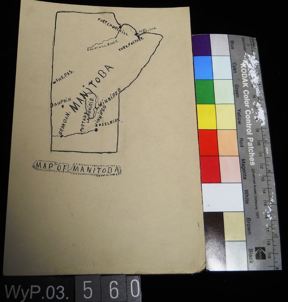
Map of Manitoba
https://archives.whyte.org/en/permalink/artifactwyp.03.560
- Date
- 1917 – 1929
- Medium
- ink; graphite on paper
- Catalogue Number
- WyP.03.560
- Description
- Pencil and ink drawing of a map of Manitoba with rivers, lakes and urban centres labeled. [Below drawing, surrounded by circle of short marks] MAP of MANITOBA
1 image
- Title
- Map of Manitoba
- Date
- 1917 – 1929
- Medium
- ink; graphite on paper
- Dimensions
- 22.5 x 15.1 cm
- Description
- Pencil and ink drawing of a map of Manitoba with rivers, lakes and urban centres labeled. [Below drawing, surrounded by circle of short marks] MAP of MANITOBA
- Credit
- Gift of Catharine Robb Whyte, O. C., Banff, 1979
- Catalogue Number
- WyP.03.560
Images
This material is presented as originally created; it may contain outdated cultural descriptions and
potentially offensive content.
Read more.
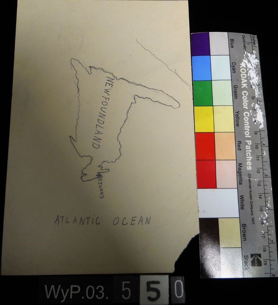
Map of Newfoundland
https://archives.whyte.org/en/permalink/artifactwyp.03.550
- Date
- n.d.
- Medium
- graphite on paper
- Catalogue Number
- WyP.03.550
- Description
- A pencil drawn map of Newfoundland, including the Atlantic Ocean.
1 image
- Title
- Map of Newfoundland
- Date
- n.d.
- Medium
- graphite on paper
- Dimensions
- 22.5 x 15.1 cm
- Description
- A pencil drawn map of Newfoundland, including the Atlantic Ocean.
- Subject
- map
- cartography
- Newfoundland
- Atlantic Ocean
- Credit
- Gift of Catharine Robb Whyte, O. C., Banff, 1979
- Catalogue Number
- WyP.03.550
Images
This material is presented as originally created; it may contain outdated cultural descriptions and
potentially offensive content.
Read more.
Map of Ontario
https://archives.whyte.org/en/permalink/artifactwyp.03.559
- Date
- 1917 – 1929
- Medium
- graphite; ink on paper
- Catalogue Number
- WyP.03.559
- Description
- Pencil and ink drawing of Ontario, the Manitoba border, and Great Lakes with rivers and urban centres labeled.title: MAP OF ONTARIO [top left, surrounded by short marks]
1 image
- Title
- Map of Ontario
- Date
- 1917 – 1929
- Medium
- graphite; ink on paper
- Dimensions
- 15.1 x 22.5 cm
- Description
- Pencil and ink drawing of Ontario, the Manitoba border, and Great Lakes with rivers and urban centres labeled.title: MAP OF ONTARIO [top left, surrounded by short marks]
- Credit
- Gift of Catharine Robb Whyte, O. C., Banff, 1979
- Catalogue Number
- WyP.03.559
Images

This material is presented as originally created; it may contain outdated cultural descriptions and
potentially offensive content.
Read more.
- Date
- n.d.
- Medium
- graphite; ink on paper
- Catalogue Number
- WyP.03.549
- Description
- An ink and pencil drawing of Quebec, New Brunswick, Ontario and Manitoba, from a cartographical perspective.
1 image
- Title
- Map of Quebec
- Date
- n.d.
- Medium
- graphite; ink on paper
- Dimensions
- 22.5 x 15.1 cm
- Description
- An ink and pencil drawing of Quebec, New Brunswick, Ontario and Manitoba, from a cartographical perspective.
- Subject
- map
- cartography
- Ontario
- Manitoba
- New Brunswick
- Quebec
- Credit
- Gift of Catharine Robb Whyte, O. C., Banff, 1979
- Catalogue Number
- WyP.03.549
Images

This material is presented as originally created; it may contain outdated cultural descriptions and
potentially offensive content.
Read more.
- Date
- 1917 – 1966
- Medium
- ink on paper
- Catalogue Number
- WyP.03.513
- Description
- A detailed ink drawing of a map South America, in a double-rectangle border.
1 image
- Title
- South America
- Date
- 1917 – 1966
- Medium
- ink on paper
- Dimensions
- 23.5 x 15.1 cm
- Description
- A detailed ink drawing of a map South America, in a double-rectangle border.
- Subject
- South America
- map
- Credit
- Gift of Catharine Robb Whyte, O. C., Banff, 1975
- Catalogue Number
- WyP.03.513
Images

This material is presented as originally created; it may contain outdated cultural descriptions and
potentially offensive content.
Read more.
Torpedo Car [on verso]
https://archives.whyte.org/en/permalink/artifactwyp.03.563
- Date
- 1917 – 1929
- Medium
- graphite on paper
- Catalogue Number
- WyP.03.563
- Description
- Drawings on both sides of the paper. Side 1 is a pencil drawing of a map of North America, including CANADA, US and MEXiCO all labeled.Verso is a pencil drawing of two figures in a car, facing left. Dust at tires and streak lines suggest speed. Titled in tlc as TORPEDO CAR
1 image
- Title
- Torpedo Car [on verso]
- Date
- 1917 – 1929
- Medium
- graphite on paper
- Dimensions
- 22.5 x 15.1 cm
- Description
- Drawings on both sides of the paper. Side 1 is a pencil drawing of a map of North America, including CANADA, US and MEXiCO all labeled.Verso is a pencil drawing of two figures in a car, facing left. Dust at tires and streak lines suggest speed. Titled in tlc as TORPEDO CAR
- Credit
- Gift of Catharine Robb Whyte, O. C., Banff, 1979
- Catalogue Number
- WyP.03.563
Images

This material is presented as originally created; it may contain outdated cultural descriptions and
potentially offensive content.
Read more.