Narrow Results By
1978 map of Mount Assiniboine Provincial Park
https://archives.whyte.org/en/permalink/catalogue21315
- Medium
- Library - Maps and blueprints (unannotated; published)
- Map
- Published Date
- 1978 (transfered to manuscrpits Oct. 1994)
- Publisher
- Ministry of Recreation and Conservation
- Call Number
- C2-10.1 (e)
- Publisher
- Ministry of Recreation and Conservation
- Published Date
- 1978 (transfered to manuscrpits Oct. 1994)
- Subjects
- Mount Assiniboine Provincial Park
- Notes
- Descriptive Legend on back of map re: History Winter Activity, Access, Avalanche Safety, Equipment, Trail and Camping Information etc.
- Accession Number
- 11000
- Call Number
- C2-10.1 (e)
- Collection
- Archives Library
This material is presented as originally created; it may contain outdated cultural descriptions and
potentially offensive content.
Read more.
[BRIDGE PLAN #1 - Plan of Proposed Bridge Site for Healy Creek at mile 4.2] (3)
https://archives.whyte.org/en/permalink/catalogue23236
- Medium
- Library - Maps and blueprints (unannotated; published)
- Map
- Published Date
- Dec. 14, 1946/Jan. 14, 1947
- Publisher
- Engineering and Construction Service, Surveys and Engineering Branch, Dept. of Mines and Resources, Banff, Alta.
- Call Number
- C2-10.1 (d)
- Publisher
- Engineering and Construction Service, Surveys and Engineering Branch, Dept. of Mines and Resources, Banff, Alta.
- Published Date
- Dec. 14, 1946/Jan. 14, 1947
- Scale
- Scale: 1 ": 40 ft.
- Relief: Counter interval 2ft.
- Subjects
- Mount Assiniboine Provincial Park
- Notes
- 4) BRIDGE PLAN #2- Plan of Proposed Bridge Site for Healy Creek at Mile 9.8
- Healy Creek - Mt. Assiniboine Highway survey by K.R. Ford
- Accession Number
- 2158
- Call Number
- C2-10.1 (d)
- Collection
- Archives Library
This material is presented as originally created; it may contain outdated cultural descriptions and
potentially offensive content.
Read more.
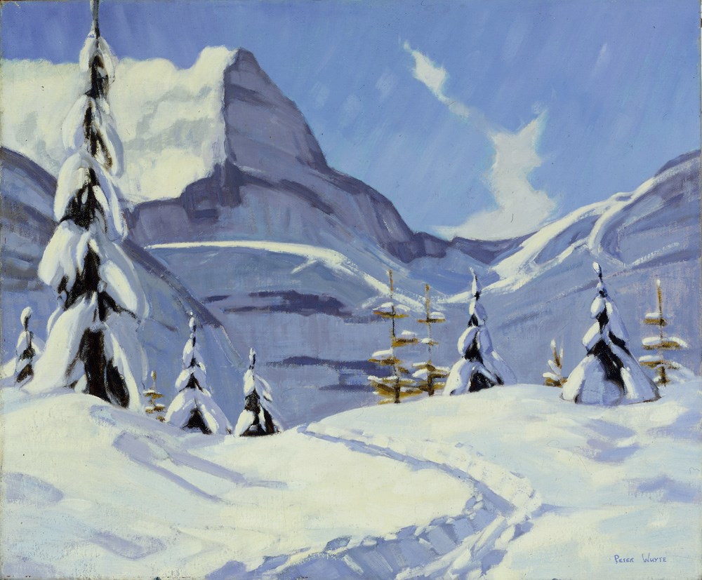
Early Snow, Mount Assiniboine
https://archives.whyte.org/en/permalink/artifactwyp.01.164
- Date
- 1937
- Medium
- oil on canvas
- Catalogue Number
- WyP.01.164
- Description
- A sunny day with lots of snow, a ski trail of path leading up to a snow-covered mountain to the left. In immediate foreground is an evergreen to the left, some gold snow-covered larches on the crest of the hill especially to the right. Blue sky with a few wispy white clouds.
1 image
- Title
- Early Snow, Mount Assiniboine
- Date
- 1937
- Medium
- oil on canvas
- Dimensions
- 27.2 x 35.5 cm
- Description
- A sunny day with lots of snow, a ski trail of path leading up to a snow-covered mountain to the left. In immediate foreground is an evergreen to the left, some gold snow-covered larches on the crest of the hill especially to the right. Blue sky with a few wispy white clouds.
- Credit
- Gift of Catharine Robb Whyte, O. C., Banff, 1979
- Catalogue Number
- WyP.01.164
Images
This material is presented as originally created; it may contain outdated cultural descriptions and
potentially offensive content.
Read more.
[Mount Assiniboine]
https://archives.whyte.org/en/permalink/catalogue23749
- Medium
- Library - Maps and blueprints (unannotated; published)
- Map
- Published Date
- 1965
- Publisher
- Dept. of Mines and Technical Surveys
- Call Number
- NTS
- 82J/13W
- Publisher
- Dept. of Mines and Technical Surveys
- Published Date
- 1965
- Physical Description
- Black and white
- Scale
- Scale: 1:50,000
- Relief: Contour interval 100 ft.
- Subjects
- Mount Assiniboine
- Notes
- (Advance Print)
- Accession Number
- 673
- Call Number
- NTS
- 82J/13W
- Collection
- Archives Library
This material is presented as originally created; it may contain outdated cultural descriptions and
potentially offensive content.
Read more.
[Mount Assiniboine]
https://archives.whyte.org/en/permalink/catalogue24098
- Medium
- Library - Maps and blueprints (unannotated; published)
- Map
- Published Date
- 1962
- Publisher
- Dept. of Mines and Technical Surveys
- Edition
- Advance Print
- Call Number
- NTS
- 82J/13W
- Edition
- Advance Print
- Publisher
- Dept. of Mines and Technical Surveys
- Published Date
- 1962
- Scale
- Scale: 1:25,000
- Relief: Contour interval 100 ft.
- Subjects
- Mount Assiniboine
- Notes
- Photostatic copy
- Accession Number
- 355
- Call Number
- NTS
- 82J/13W
- Collection
- Archives Library
This material is presented as originally created; it may contain outdated cultural descriptions and
potentially offensive content.
Read more.
Mount Assiniboine
https://archives.whyte.org/en/permalink/artifacthuw.02.02
- Date
- 1994
- Medium
- oil on paperboard
- Catalogue Number
- HuW.02.02
- Description
- Snow-capped mountain centre top, yellow tinged mountain face meets the green forest floor at bottom fifth of painting. Evergreen trees frame both sides with bare trunks on right side.
- Title
- Mount Assiniboine
- Date
- 1994
- Medium
- oil on paperboard
- Dimensions
- 119.5 x 81.4 cm
- Description
- Snow-capped mountain centre top, yellow tinged mountain face meets the green forest floor at bottom fifth of painting. Evergreen trees frame both sides with bare trunks on right side.
- Credit
- Gift of Dorothy Hutchinson, Winnipeg, 1994
- Catalogue Number
- HuW.02.02
This material is presented as originally created; it may contain outdated cultural descriptions and
potentially offensive content.
Read more.
[Mount Assiniboine - edition 2]
https://archives.whyte.org/en/permalink/catalogue23746
- Medium
- Library - Maps and blueprints (unannotated; published)
- Map
- Published Date
- 1977
- Publisher
- Surveys and Mapping Branch, D.E.M.R.
- Edition
- 2
- Call Number
- NTS
- 82J/13
- Edition
- 2
- Publisher
- Surveys and Mapping Branch, D.E.M.R.
- Published Date
- 1977
- Physical Description
- Colour
- Scale
- Scale: 1:50,000
- Relief: Contour interval 100 feet
- Subjects
- Mount Assiniboine - edition 2
- Notes
- National Topographic System
- Accession Number
- 10,000
- Call Number
- NTS
- 82J/13
- Collection
- Archives Library
This material is presented as originally created; it may contain outdated cultural descriptions and
potentially offensive content.
Read more.
[Mount Assiniboine 82 J/13 East - B.C.-Alta.]
https://archives.whyte.org/en/permalink/catalogue23747
- Medium
- Library - Maps and blueprints (unannotated; published)
- Map
- Published Date
- 1966
- Publisher
- Dept. of Mines and Technical Surveys
- Call Number
- NTS
- 82J/13E
- Publisher
- Dept. of Mines and Technical Surveys
- Published Date
- 1966
- Physical Description
- Colour
- Scale
- Scale: 1:50,000
- Relief: Contour interval 100'
- Notes
- National Topographic System
- Dup. in Map Room
- Accession Number
- 718
- Call Number
- NTS
- 82J/13E
- Collection
- Archives Library
This material is presented as originally created; it may contain outdated cultural descriptions and
potentially offensive content.
Read more.
[Mount Assiniboine 82 J/13 West - B.C.-Alta.]
https://archives.whyte.org/en/permalink/catalogue23748
- Medium
- Library - Maps and blueprints (unannotated; published)
- Map
- Published Date
- 1966
- Publisher
- Dept. of Mines and Technical Surveys
- Call Number
- NTS
- 82J/13W
- Publisher
- Dept. of Mines and Technical Surveys
- Published Date
- 1966
- Physical Description
- Colour
- Scale
- Scale: 1:50,000
- Relief: Contour interval 100 ft.
- Notes
- National Topographic System
- Dup. in Map Room
- Accession Number
- 718
- Call Number
- NTS
- 82J/13W
- Collection
- Archives Library
This material is presented as originally created; it may contain outdated cultural descriptions and
potentially offensive content.
Read more.
[Mount Assiniboine 82J/NW, B.C.]
https://archives.whyte.org/en/permalink/catalogue23990
- Medium
- Library - Maps and blueprints (unannotated; published)
- Map
- Published Date
- 1971
- Publisher
- Dept. of Lands and Forests & Water Resources
- Call Number
- NTS
- 82J/NW
- Publisher
- Dept. of Lands and Forests & Water Resources
- Published Date
- 1971
- Physical Description
- 1 map : col
- Scale
- Scale: 1:126,720
- Relief: Contour Interval 100 ft.
- Subjects
- Mount Assiniboine
- British Columbia
- Notes
- National Topographic System
- Accession Number
- 3000
- Call Number
- NTS
- 82J/NW
- Collection
- Archives Library
This material is presented as originally created; it may contain outdated cultural descriptions and
potentially offensive content.
Read more.