Narrow Results By
Canadian Rockies
https://archives.whyte.org/en/permalink/descriptions54817
- Part Of
- Murray Hay fonds
- Scope & Content
- File consists of 1 cm of textual records, 10 x 22 cm. File pertains to tourist maps of the Canadian Rocky Mountains created by Murray Hay. File includes a brochure of titled "Canadian Rockies Access Maps" that, when unfolded, includes several maps of the various areas that make up the Canadian Rock…
- Date Range
- ca. 1990 - 1999
- 1999
- Reference Code
- M570 / III / D / i / 2
- Description Level
- 5 / File
- GMD
- Published record
- Map
- Textual record
- Part Of
- Murray Hay fonds
- Description Level
- 5 / File
- Fonds Number
- M570 / V795
- Series
- M570 / III : Murray Hay portfolio (published material)
- Sous-Fonds
- M570
- Sub-Series
- M570 / III / D : Miscellaneous / i : Canada (general)
- Accession Number
- 2019.41
- Reference Code
- M570 / III / D / i / 2
- Date Range
- ca. 1990 - 1999
- 1999
- Physical Description
- 1 cm of textual records (10 x 22 cm)
- Scope & Content
- File consists of 1 cm of textual records, 10 x 22 cm. File pertains to tourist maps of the Canadian Rocky Mountains created by Murray Hay. File includes a brochure of titled "Canadian Rockies Access Maps" that, when unfolded, includes several maps of the various areas that make up the Canadian Rocky Mountains, like Kananaskis Country, Canmore, Banff National Park, Jasper National Park, Yoho National Park, etc.
- Name Access
- Hay, Murray
- Subject Access
- Advertising
- Artist
- Banff
- Banff National Park
- Cartography
- Communications
- Lake Louise
- Kananaskis Country
- Map
- Mountains
- Tourism
- Tourist information
- Travel
- Geographic Access
- Canada
- Canadian Rocky Mountains
- Alberta
- British Columbia
- Yoho National Park
- Jasper National Park
- Banff National Park
- Glacier National Park
- Canmore
- Banff
- Jasper
- Lake Louise
- Kananaskis
- Kananaskis Country
- Kootenay National Park
- Language
- English
- Title Source
- Title based on contents of file
- Processing Status
- Processed
This material is presented as originally created; it may contain outdated cultural descriptions and
potentially offensive content.
Read more.
- Part Of
- Murray Hay fonds
- Scope & Content
- File consists of 8 colour prints, 28 x 35 cm or smaller. File pertains to Murray Hay's work for the City of Kimberley, British Columbia. File includes prints of original paintings done by Hay relating to a proposed real estate development in the city and the Kimberley ski hill.
- Date Range
- ca.1979-ca.2000
- Reference Code
- V795 / II / A / iii / 1-2
- Description Level
- 5 / File
- GMD
- Map
- Private record
- Part Of
- Murray Hay fonds
- Description Level
- 5 / File
- Fonds Number
- M570 / V795
- Series
- V795 / II : Unpublished Material
- Sous-Fonds
- V795
- Sub-Series
- V795 / II / A : British Columbia / iii : Kimberley
- Accession Number
- 2019.41
- Reference Code
- V795 / II / A / iii / 1-2
- GMD
- Map
- Private record
- Date Range
- ca.1979-ca.2000
- Physical Description
- 8 prints : col. ; 28 x 35 cm or smaller
- Scope & Content
- File consists of 8 colour prints, 28 x 35 cm or smaller. File pertains to Murray Hay's work for the City of Kimberley, British Columbia. File includes prints of original paintings done by Hay relating to a proposed real estate development in the city and the Kimberley ski hill.
- Notes
- The ski hill at Kimberley was developed in 1979.
- Most of the prints are annotated in ink by Hay (his own notes and comments by clients).
- Name Access
- Hay, Murray
- Subject Access
- Advertising
- Artist
- Art
- Cartography
- Community life
- Landscapes
- Map
- Mountains
- Municipal views
- Ski area
- Ski Maps
- Sports and recreation
- Tourism
- Tourist information
- Winter
- Kimberley Alpine Resort
- Geographic Access
- Kimberley
- British Columbia
- Canada
- Purcell Mountains
- Language
- English
- Conservation
- There is masking tape holding some of the prints together on a piece of paper, which should be removed and alternative preservation methods should be considered at a reasonable time to do so.
- Creator
- Hay, Murray
- Title Source
- Title based on contents of file
- Processing Status
- Processed
This material is presented as originally created; it may contain outdated cultural descriptions and
potentially offensive content.
Read more.
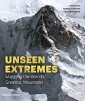
Mountains : mapping the earth's extremes
https://archives.whyte.org/en/permalink/catalogue19921
- Medium
- Library - Book (including soft-cover and pamphlets)
- Published Date
- 2016
- Author
- Dech, Stefan
- Messner, Reinhold
- Sparwasser, Nils
- Publisher
- London, England : Thames and Hudson
- Call Number
- GA D43 M68
1 website
- Responsibility
- Stefan Dech, Reinhold Messner, Nils Sparwasser
- Publisher
- London, England : Thames and Hudson
- Published Date
- 2016
- Physical Description
- 240 p. illus. (colour)
- Subjects
- Mountains
- Maps
- Cartography
- Photography, Aerial
- Abstract
- Mountains marks a new milestone in Earth observation and Alpine exploration. For the first time, a special recording process and a technique developed at the German Aerospace Center (DLR) allow the satellite recording of three-dimensional views from 300 miles above with a resolution in the range of a few meters. Photorealistic images are created in this manner from perspectives denied even to mountaineers and helicopter pilots. In addition to highly accurate detailed models of individual regions, the DLR generates a global three-dimensional elevation model of Earth in unprecedented quality. For this purpose, two German satellites are currently circling the earth at a speed of more than 15,000 miles per hour—separated by a mere 500 feet. Taken together, both techniques offer a detailed view of a world that still pushes human beings to their limits—the mountainous regions of our planet. For this book Reinhold Messner has selected thirteen peaks and routes to feature, as they’ve never been seen before. (from publisher's website)
- Contents
- Trailblazers
- Mountains: the fourth dimension
- Of scientists and mountaineers : the making of this book
- Kailash
- Mont Blanc
- Matterhorn
- Ushba
- Denali
- Aconcagua
- Nanda Devi
- Mount Everest
- K2
- Dhaulagiri
- Annapurna
- Masherbrum
- Histories
- Profiles
- From data to images
- Editors, authors and project partners
- Index
- ISBN
- 9780500518892
- Accession Number
- AC635
- Call Number
- GA D43 M68
- Collection
- Alpine Club of Canada Library
- URL Notes
- Publisher's website
Websites
This material is presented as originally created; it may contain outdated cultural descriptions and
potentially offensive content.
Read more.
Reference Material
https://archives.whyte.org/en/permalink/descriptions54749
- Part Of
- Murray Hay fonds
- Scope & Content
- File consists of 2.5 cm of textual material, 45.5 x 60.5 cm or smaller. File consists of miscellaneous research and reference material related to Murray Hay's work projects. File includes various brochures and tourism booklets about Alaska (one of Hay's projects in the 1990s) and a promotional post…
- Date Range
- 1982- ca.1999
- 1982
- 1993-1994
- ca.1999
- Reference Code
- M570 / II / 1-2
- Description Level
- 5 / File
- GMD
- Published record
- Textual record
- Part Of
- Murray Hay fonds
- Description Level
- 5 / File
- Fonds Number
- M570 / V795
- Series
- M570 / II : Research and Reference Material
- Sous-Fonds
- M570
- Accession Number
- 2019.41
- Reference Code
- M570 / II / 1-2
- Date Range
- 1982- ca.1999
- 1982
- 1993-1994
- ca.1999
- Physical Description
- 2.5 cm of textual records (45.5 x 60.5 cm or smaller)
- Scope & Content
- File consists of 2.5 cm of textual material, 45.5 x 60.5 cm or smaller. File consists of miscellaneous research and reference material related to Murray Hay's work projects. File includes various brochures and tourism booklets about Alaska (one of Hay's projects in the 1990s) and a promotional poster of the Mt. Everest Canadian Expedition (1982).
- Notes
- M570 / II / 2 is oversize.
- Hay produced a map of the route of the Mt. Everest Canadian Expedition that was used for promotional purposes and in books produced by Pat Morrow (a participant of the expedition). This poster also has smaller images of all of the participants.
- One of the booklets in M570 / II / 1 is published in German.
- Name Access
- Hay, Murray
- Subject Access
- Advertising
- Airplane
- Cartography
- Discovery and travel
- Everest '82
- Mountains
- Promo
- Research
- Trails
- Travel
- Landscapes
- Climbing
- Geographic Access
- Alaska
- United States
- United States of America
- Nepal
- Mount Everest
- Language
- English
- German
- Title Source
- Title based on contents of file
- Processing Status
- Processed
This material is presented as originally created; it may contain outdated cultural descriptions and
potentially offensive content.
Read more.
Yoho National Park
https://archives.whyte.org/en/permalink/descriptions54863
- Part Of
- Murray Hay fonds
- Scope & Content
- File consists of 19 colour photographs, 15 x 10 cm or smaller (some are pasted on to a piece of paper, 21.5 x 28 cm). File pertains to projects Murray Hay worked on related to Yoho National Park, specifically Emerald Lake and Lake O'Hara. Photographs depict original paintings created by Hay.
- Date Range
- ca.1980-ca.2000
- Reference Code
- V795 / II / A / i / 1
- Description Level
- 5 / File
- GMD
- Photograph print
- Photograph
- Private record
- Part Of
- Murray Hay fonds
- Description Level
- 5 / File
- Fonds Number
- M570 / V795
- Series
- V795 / II : Unpublished Material
- Sous-Fonds
- V795
- Sub-Series
- V795 / II / A : British Columbia / i : Yoho National Park
- Accession Number
- 2019.41
- Reference Code
- V795 / II / A / i / 1
- Date Range
- ca.1980-ca.2000
- Physical Description
- 19 photographs : col. ; 15 x 10 cm or smaller
- Scope & Content
- File consists of 19 colour photographs, 15 x 10 cm or smaller (some are pasted on to a piece of paper, 21.5 x 28 cm). File pertains to projects Murray Hay worked on related to Yoho National Park, specifically Emerald Lake and Lake O'Hara. Photographs depict original paintings created by Hay.
- Notes
- Many of the photographic prints are either taped together in a specific way or or taped to a separate sheet of paper and labelled accordingly. They remain filed this way as this demonstrates Hay's process of creating paintings and maps.
- Name Access
- Hay, Murray
- Subject Access
- Artist
- Art
- Cartography
- Landscapes
- Mountains
- Photography
- Professional and Personal Life
- Geographic Access
- Yoho National Park
- British Columbia
- Canada
- Canadian Rocky Mountains
- Emerald Lake
- Lake O'Hara
- Language
- English
- Conservation
- There is masking tape holding the phtoographs together, which should be removed and alternative preservation methods should be considered at a reasonable time to do so.
- Title Source
- Title based on contents of file
- Processing Status
- Processed
This material is presented as originally created; it may contain outdated cultural descriptions and
potentially offensive content.
Read more.