Narrow Results By
A man and his century : Gerald Smedley Andrews, teacher, forester, surveyor, engineer, author, artist, Surveyor General of British Columbia, 1951-1968
https://archives.whyte.org/en/permalink/catalogue12600
- Medium
- Library - Book (including soft-cover and pamphlets)
- Published Date
- 2003
- Author
- Andrews, Mary
- Publisher
- Victoria : M. Andrews
- Call Number
- 03.7 An2a
- Author
- Andrews, Mary
- Responsibility
- Mary E. Andrews and Doreen J. Hunter
- Publisher
- Victoria : M. Andrews
- Published Date
- 2003
- Physical Description
- 56p. : ill
- Subjects
- Photography, Aerial
- ISBN
- 0973434902
- Accession Number
- 7546
- Call Number
- 03.7 An2a
- Collection
- Archives Library
This material is presented as originally created; it may contain outdated cultural descriptions and
potentially offensive content.
Read more.

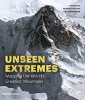
Mountains : mapping the earth's extremes
https://archives.whyte.org/en/permalink/catalogue19921
- Medium
- Library - Book (including soft-cover and pamphlets)
- Published Date
- 2016
- Author
- Dech, Stefan
- Messner, Reinhold
- Sparwasser, Nils
- Publisher
- London, England : Thames and Hudson
- Call Number
- GA D43 M68
1 website
- Responsibility
- Stefan Dech, Reinhold Messner, Nils Sparwasser
- Publisher
- London, England : Thames and Hudson
- Published Date
- 2016
- Physical Description
- 240 p. illus. (colour)
- Subjects
- Mountains
- Maps
- Cartography
- Photography, Aerial
- Abstract
- Mountains marks a new milestone in Earth observation and Alpine exploration. For the first time, a special recording process and a technique developed at the German Aerospace Center (DLR) allow the satellite recording of three-dimensional views from 300 miles above with a resolution in the range of a few meters. Photorealistic images are created in this manner from perspectives denied even to mountaineers and helicopter pilots. In addition to highly accurate detailed models of individual regions, the DLR generates a global three-dimensional elevation model of Earth in unprecedented quality. For this purpose, two German satellites are currently circling the earth at a speed of more than 15,000 miles per hour—separated by a mere 500 feet. Taken together, both techniques offer a detailed view of a world that still pushes human beings to their limits—the mountainous regions of our planet. For this book Reinhold Messner has selected thirteen peaks and routes to feature, as they’ve never been seen before. (from publisher's website)
- Contents
- Trailblazers
- Mountains: the fourth dimension
- Of scientists and mountaineers : the making of this book
- Kailash
- Mont Blanc
- Matterhorn
- Ushba
- Denali
- Aconcagua
- Nanda Devi
- Mount Everest
- K2
- Dhaulagiri
- Annapurna
- Masherbrum
- Histories
- Profiles
- From data to images
- Editors, authors and project partners
- Index
- ISBN
- 9780500518892
- Accession Number
- AC635
- Call Number
- GA D43 M68
- Collection
- Alpine Club of Canada Library
- URL Notes
- Publisher's website
Websites
This material is presented as originally created; it may contain outdated cultural descriptions and
potentially offensive content.
Read more.