Narrow Results By
Road map and parks guide : Super Natural British Columbia, Canada
https://archives.whyte.org/en/permalink/catalogue24516
- Medium
- Library - Maps and blueprints (unannotated; published)
- Map
- Published Date
- 1989/90
- Publisher
- Victoria: British Columbia, Ministry of Tourism and Provincial Secretary
- Call Number
- C10-1.5
- Publisher
- Victoria: British Columbia, Ministry of Tourism and Provincial Secretary
- Published Date
- 1989/90
- Physical Description
- 20 maps on 1 sheet : col
- Scale
- Scale: 1:2,500,000
- Notes
- Issued as folder with title: Road map and parks guide : Super Natural British Columbia, Canada
- Maps of cities, regions, provincial park index on reverse
- Call Number
- C10-1.5
- Collection
- Archives Library
This material is presented as originally created; it may contain outdated cultural descriptions and
potentially offensive content.
Read more.
Provincial parks of the Kootenays
https://archives.whyte.org/en/permalink/catalogue24522
- Medium
- Library - Maps and blueprints (unannotated; published)
- Map
- Publisher
- Province of British Columbia, Ministry of Parks, Kamloops
- Edition
- Rev. ed
- Call Number
- C10-2.8
- Edition
- Rev. ed
- Publisher
- Province of British Columbia, Ministry of Parks, Kamloops
- Physical Description
- 1 map : col
- Scale
- Scale: 1 cm = 10 km
- Notes
- Part of a brochure (textual matter on reverse)
- Info file transfer
- Call Number
- C10-2.8
- Collection
- Archives Library
This material is presented as originally created; it may contain outdated cultural descriptions and
potentially offensive content.
Read more.
Update on park closures
https://archives.whyte.org/en/permalink/catalogue25164
- Physical Description
- p. 4
- Medium
- Library - Periodical
- Abstract
- Pertains to the Alberta governments plan to close many Alberta parks to address their budget issues.
- Notes
- In Nature Alberta, vol.50, no.3 (Fall 2020)
- Call Number
- P
- Collection
- Archives Library
- URL Notes
- Available online via Nature Alberta website
Websites
This material is presented as originally created; it may contain outdated cultural descriptions and
potentially offensive content.
Read more.
Updates - "Optimizing" Alberta's Parks means losing protection where we need it most ; AWA and the Grassy Mountain coal project joint review panel hearings ; Coalspur Vista coal mine Phase II : frustration served by the Alberta energy regulator ; AWA to participate in managing the Ronald Lake bison herd
https://archives.whyte.org/en/permalink/catalogue25219
- Medium
- Library - Periodical
- Published Date
- 2020
- Author
- Petterson, Nissa
- Wark, Grace
- Urquhart, Ian
- Olson, Christyann
- Publisher
- The Alberta Wilderness Association Journal
- Call Number
- P
1 website
- Responsibility
- Nissa Petterson
- Grace Wark
- Ian Irquhart
- Christyann Olson
- Publisher
- The Alberta Wilderness Association Journal
- Published Date
- 2020
- Physical Description
- pg. 28 - 29
- Medium
- Library - Periodical
- Subjects
- Alberta
- Politics
- Coal
- Coal and coal mines
- Provincial Parks
- Provincial parks and reserves
- Bison
- Wildlife management
- Abstract
- Pertains to updates on the following projects in Alberta: "Optimizing" Alberta's Parks means losing protection where we need it most ; AWA and the Grassy Mountain coal project joint review panel hearings ; Coalspur Vista coal mine Phase II : frustration served by the Alberta energy regulator ; AWA to participate in managing the Ronald Lake bison herd
- Notes
- In Wildlands Advocate, Vol. 28, No.3, September 2020
- Call Number
- P
- Collection
- Archives Library
- URL Notes
- Digital copy available
Websites
This material is presented as originally created; it may contain outdated cultural descriptions and
potentially offensive content.
Read more.
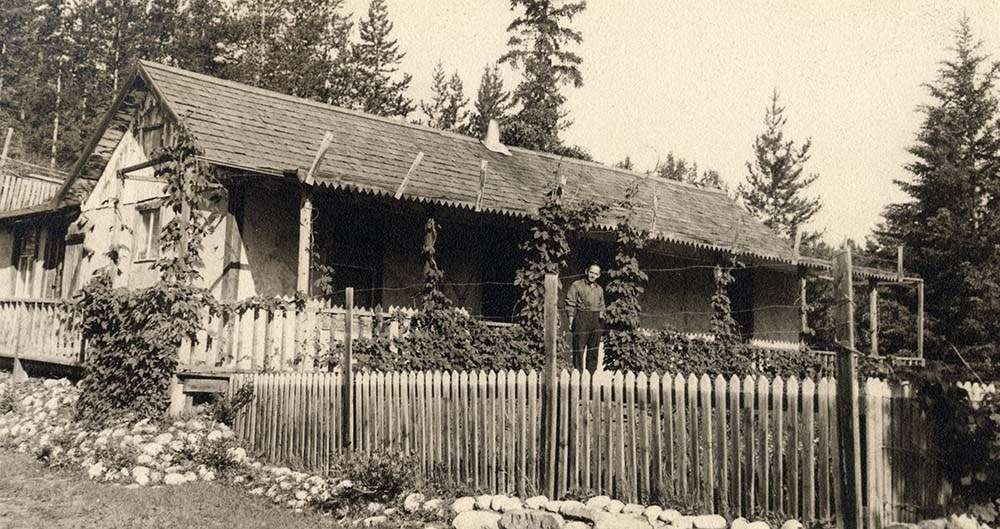
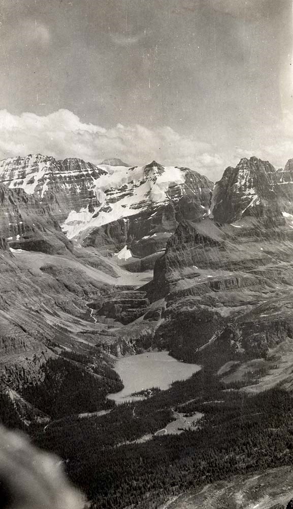
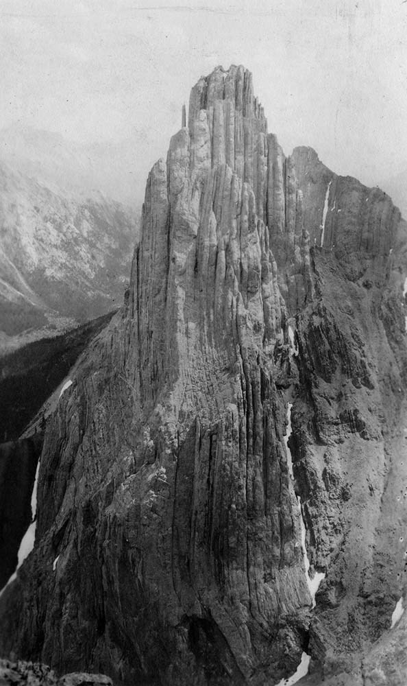
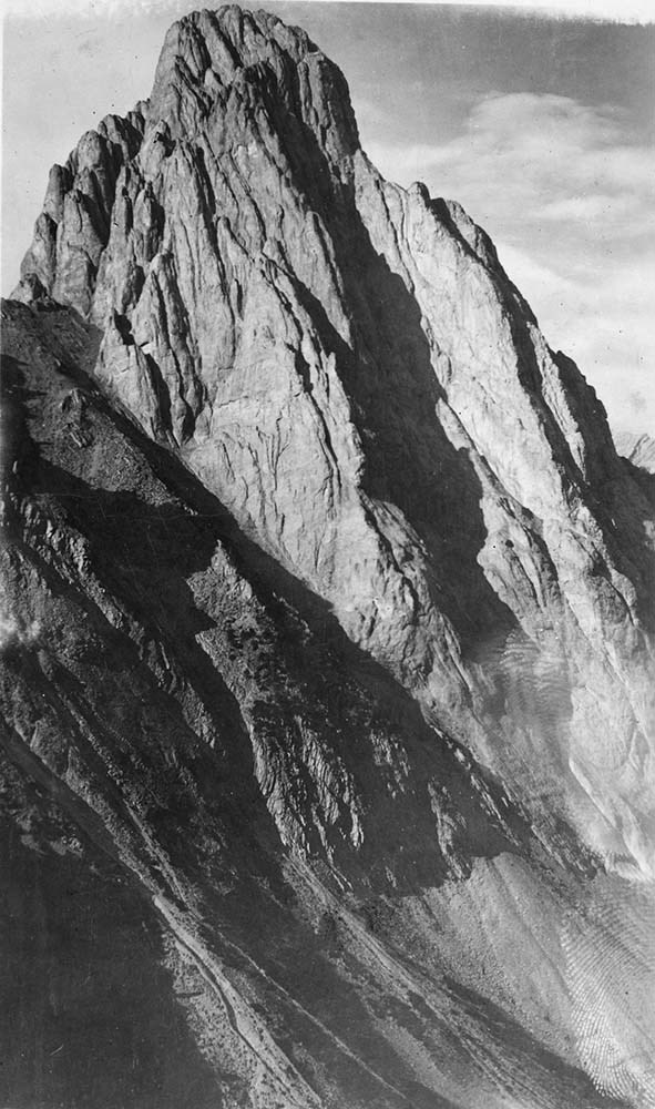
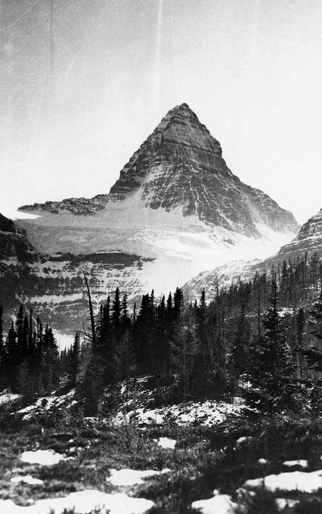
Canadian Rockies Photograph Album
https://archives.whyte.org/en/permalink/descriptions3599
- Part Of
- Lawrence Grassi fonds
- Scope & Content
- File pertains to a photo album that Includes an assortment of views of the Canadian Rockies; mainly duplicates of those images in Series I. Landscape Photographs. Item-level inventory available.
- Date Range
- [ca. 1930-1970]
- Reference Code
- V240 / II / A / PD - 624
- Description Level
- 5 / File
- GMD
- Album
- Photograph
6 images
- Part Of
- Lawrence Grassi fonds
- Description Level
- 5 / File
- Fonds Number
- M45 / V240
- Series
- II.A. Landscape photographs
- Sous-Fonds
- V240
- Accession Number
- 3159
- Reference Code
- V240 / II / A / PD - 624
- GMD
- Album
- Photograph
- Date Range
- [ca. 1930-1970]
- Physical Description
- 1 photograph album (180 prints)
- History / Biographical
- See fonds level description
- Scope & Content
- File pertains to a photo album that Includes an assortment of views of the Canadian Rockies; mainly duplicates of those images in Series I. Landscape Photographs. Item-level inventory available.
- Name Access
- Grassi, Lawrence
- Subject Access
- Activities
- Alpine Club of Canada
- Animals
- Cabins and shelters
- Camps
- Environment and Nature
- Exploration
- Family and personal life
- Grassi Lakes
- Home
- Kananaskis Country
- Lake O'Hara region
- Mountains
- Parks
- Provincial parks and reserves
- Scenery
- Trails
- Trail making
- Travel
- Geographic Access
- Canmore
- Lake Louise
- Lake O'Hara
- Banff
- Banff National Park
- Yoho National Park
- Kananaskis
- Alberta
- British Columbia
- Canada
- Language
- English
- Title Source
- Title based on contents of file
- Processing Status
- Processed
Images

This material is presented as originally created; it may contain outdated cultural descriptions and
potentially offensive content.
Read more.
B.C. Provincial Parks
https://archives.whyte.org/en/permalink/descriptions8478
- Part Of
- Peter and Catharine Whyte fonds
- Date Range
- 1966-1973
- Reference Code
- M36 / I / A / 4 / b / iii / 1363
- Description Level
- 5 / File
- Part Of
- Peter and Catharine Whyte fonds
- Description Level
- 5 / File
- Fonds Number
- M36 / V683 / S37
- Series
- I.A.4. Catharine Robb Whyte papers / photographs
- Reference Code
- M36 / I / A / 4 / b / iii / 1363
- Date Range
- 1966-1973
- Physical Description
- 1 file of textual records
- Subject Access
- Provincial parks and reserves - B.C.
This material is presented as originally created; it may contain outdated cultural descriptions and
potentially offensive content.
Read more.
- Part Of
- Peter and Catharine Whyte fonds
- Date Range
- 1969-1970
- Reference Code
- M36 / I / A / 4 / b / iii / 1430
- Description Level
- 5 / File
- Part Of
- Peter and Catharine Whyte fonds
- Description Level
- 5 / File
- Fonds Number
- M36 / V683 / S37
- Series
- I.A.4. Catharine Robb Whyte papers / photographs
- Reference Code
- M36 / I / A / 4 / b / iii / 1430
- Date Range
- 1969-1970
- Physical Description
- 1 file of textual records
- Subject Access
- Provincial parks and reserves
This material is presented as originally created; it may contain outdated cultural descriptions and
potentially offensive content.
Read more.
Pembina River Provincial Park interpretive signs
https://archives.whyte.org/en/permalink/descriptions55898
- Part Of
- Ben Gadd fonds
- Scope & Content
- File consists of a signed contract agreement, correspondence, text drafts and sample designs pertaining to interpretive signs created by Ben Gadd on behalf of the Government of Alberta's Environmental Protection department. Interpretive signs pertain to geological history, natural features and wild…
- Date Range
- 1997
- Reference Code
- M590 / III / D / 17
- Description Level
- 5 / File
- GMD
- Textual record
- Part Of
- Ben Gadd fonds
- Description Level
- 5 / File
- Fonds Number
- M590
- V810
- S61
- Series
- M590 / III : Professional records
- Sous-Fonds
- M590
- Sub-Series
- M590 / III / D : Other contracts and projects
- Accession Number
- 2021.20
- Reference Code
- M590 / III / D / 17
- GMD
- Textual record
- Responsibility
- Produced by Ben Gadd
- Date Range
- 1997
- Physical Description
- 1.5 cm of textual records
- Scope & Content
- File consists of a signed contract agreement, correspondence, text drafts and sample designs pertaining to interpretive signs created by Ben Gadd on behalf of the Government of Alberta's Environmental Protection department. Interpretive signs pertain to geological history, natural features and wildlife in Pembina River Provincial Park.
- Name Access
- Gadd, Ben
- Subject Access
- Government
- Trails
- Guiding
- Tourism
- Travel
- Environment
- Wildlife
- Recreation
- Natural history
- Provincial parks and reserves
- Geographic Access
- Canada
- Alberta
- Pembina River Provincial Park
- Title Source
- Title based on contents of file
- Processing Status
- Processed
This material is presented as originally created; it may contain outdated cultural descriptions and
potentially offensive content.
Read more.
Whiskers Point
https://archives.whyte.org/en/permalink/descriptions56010
- Part Of
- Ben Gadd fonds
- Scope & Content
- File consists of records pertaining to Ben Gadd's contracted work producing interpretive trail signs for Whiskers Point Provincial Park for the Government of British Columbia. File includes a signed contract, correspondence, drafts, reference material (including maps), quotes from subcontractors an…
- Date Range
- 1997-1998
- Reference Code
- M590 / III / D / 36 to 37
- Description Level
- 5 / File
- GMD
- Textual record
- Published record
- Part Of
- Ben Gadd fonds
- Description Level
- 5 / File
- Fonds Number
- M590
- V810
- S61
- Series
- M590 / III : Professional records
- Sous-Fonds
- M590
- Sub-Series
- M590 / III / D : Other contracts and projects
- Accession Number
- 2021.20
- Reference Code
- M590 / III / D / 36 to 37
- Date Range
- 1997-1998
- Physical Description
- 3 cm of textual records
- Scope & Content
- File consists of records pertaining to Ben Gadd's contracted work producing interpretive trail signs for Whiskers Point Provincial Park for the Government of British Columbia. File includes a signed contract, correspondence, drafts, reference material (including maps), quotes from subcontractors and other related materials.
- Name Access
- Gadd, Ben
- Subject Access
- Natural history
- Research
- Environment
- Publication
- Travel
- Trails
- Guiding
- Government
- Provincial parks and reserves
- Geographic Access
- Canada
- British Columbia
- Whiskers Point Provincial Park
- Reproduction Restrictions
- Restrictions may apply
- Language
- English
- Category
- Environment
- Government
- Title Source
- Original title used
- Processing Status
- Processed
This material is presented as originally created; it may contain outdated cultural descriptions and
potentially offensive content.
Read more.
Kinney Lake and Robson Corridor signs
https://archives.whyte.org/en/permalink/descriptions56011
- Part Of
- Ben Gadd fonds
- Scope & Content
- File consists of records pertaining to Ben Gadd's contracted work producing interpretive signs for trails near Kinney Lake and Robson Corridor in Mt. Robson Provincial Park. File includes correspondence between Ben and the Government of British Columbia's Ministry of Environment, Lands and Parks; n…
- Date Range
- 1994-1996
- Reference Code
- M590 / III / D / 38
- Description Level
- 5 / File
- GMD
- Textual record
- Published record
- Part Of
- Ben Gadd fonds
- Description Level
- 5 / File
- Fonds Number
- M590
- V810
- S61
- Series
- M590 / III : Professional records
- Sous-Fonds
- M590
- Sub-Series
- M590 / III / D : Other contracts and projects
- Accession Number
- 2021.20
- Reference Code
- M590 / III / D / 38
- Date Range
- 1994-1996
- Physical Description
- 2 cm of textual records
- Scope & Content
- File consists of records pertaining to Ben Gadd's contracted work producing interpretive signs for trails near Kinney Lake and Robson Corridor in Mt. Robson Provincial Park. File includes correspondence between Ben and the Government of British Columbia's Ministry of Environment, Lands and Parks; notes, sample drafts and corrections; a copy of Explorer newspaper from summer 1994 pertaining to Mount Robson Provincial Park; and other related materials.
- Name Access
- Gadd, Ben
- Subject Access
- Natural history
- Research
- Environment
- Publication
- Travel
- Trails
- Guiding
- Government
- Provincial parks and reserves
- Geographic Access
- Canada
- British Columbia
- Whiskers Point Provincial Park
- Reproduction Restrictions
- Restrictions may apply
- Language
- English
- Category
- Environment
- Government
- Title Source
- Original title used
- Processing Status
- Processed
This material is presented as originally created; it may contain outdated cultural descriptions and
potentially offensive content.
Read more.