Narrow Results By
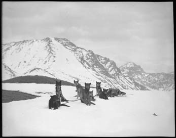
Assiniboine, dog team
https://archives.whyte.org/en/permalink/descriptions27181
- Part Of
- Byron Harmon fonds
- Scope & Content
- Mount Assiniboine area, Rocky Mountains
- Date Range
- [between 1903 and 1942]
- Reference Code
- V263 / NA - 709
- Description Level
- 6 / Item
- GMD
- Photograph
- Negative
1 image
- Part Of
- Byron Harmon fonds
- Description Level
- 6 / Item
- Fonds Number
- V263
- Series
- I. Scenic / commercial series
- Sub-Series
- A.1.a. Negatives, Main series : 13 x 18 cm and smaller
- Reference Code
- V263 / NA - 709
- GMD
- Photograph
- Negative
- Date Range
- [between 1903 and 1942]
- Physical Description
- 1 photograph : negative, duplicate, 13 x 18 cm or smaller
- Scope & Content
- Mount Assiniboine area, Rocky Mountains
- Subject Access
- Sports and Recreation
- Transportation
- Geographic Access
- British Columbia
- Creator
- Byron Harmon (Banff, Alberta)
Images

This material is presented as originally created; it may contain outdated cultural descriptions and
potentially offensive content.
Read more.
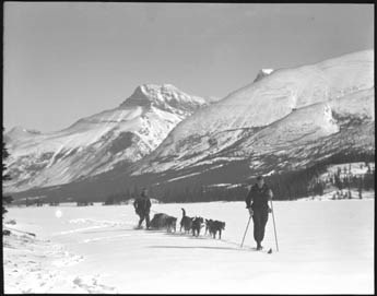
Assiniboine, dog team
https://archives.whyte.org/en/permalink/descriptions27184
- Part Of
- Byron Harmon fonds
- Scope & Content
- Mount Assiniboine area, Rocky Mountains
- Date Range
- [between 1903 and 1942]
- Reference Code
- V263 / NA - 712
- Description Level
- 6 / Item
- GMD
- Photograph
- Negative
1 image
- Part Of
- Byron Harmon fonds
- Description Level
- 6 / Item
- Fonds Number
- V263
- Series
- I. Scenic / commercial series
- Sub-Series
- A.1.a. Negatives, Main series : 13 x 18 cm and smaller
- Reference Code
- V263 / NA - 712
- GMD
- Photograph
- Negative
- Date Range
- [between 1903 and 1942]
- Physical Description
- 1 photograph : negative, duplicate, 13 x 18 cm or smaller
- Scope & Content
- Mount Assiniboine area, Rocky Mountains
- Subject Access
- Sports and Recreation
- Transportation
- Geographic Access
- British Columbia
- Creator
- Byron Harmon (Banff, Alberta)
Images
This material is presented as originally created; it may contain outdated cultural descriptions and
potentially offensive content.
Read more.
Assiniboine, dog team
https://archives.whyte.org/en/permalink/descriptions27185
- Part Of
- Byron Harmon fonds
- Scope & Content
- Mount Assiniboine area, Rocky Mountains
- Date Range
- [between 1903 and 1942]
- Reference Code
- V263 / NA - 713
- Description Level
- 6 / Item
- GMD
- Photograph
- Negative
1 image
- Part Of
- Byron Harmon fonds
- Description Level
- 6 / Item
- Fonds Number
- V263
- Series
- I. Scenic / commercial series
- Sub-Series
- A.1.a. Negatives, Main series : 13 x 18 cm and smaller
- Reference Code
- V263 / NA - 713
- GMD
- Photograph
- Negative
- Date Range
- [between 1903 and 1942]
- Physical Description
- 1 photograph : negative, duplicate, 13 x 18 cm or smaller
- Scope & Content
- Mount Assiniboine area, Rocky Mountains
- Subject Access
- Sports and Recreation
- Transportation
- Geographic Access
- British Columbia
- Creator
- Byron Harmon (Banff, Alberta)
Images
This material is presented as originally created; it may contain outdated cultural descriptions and
potentially offensive content.
Read more.
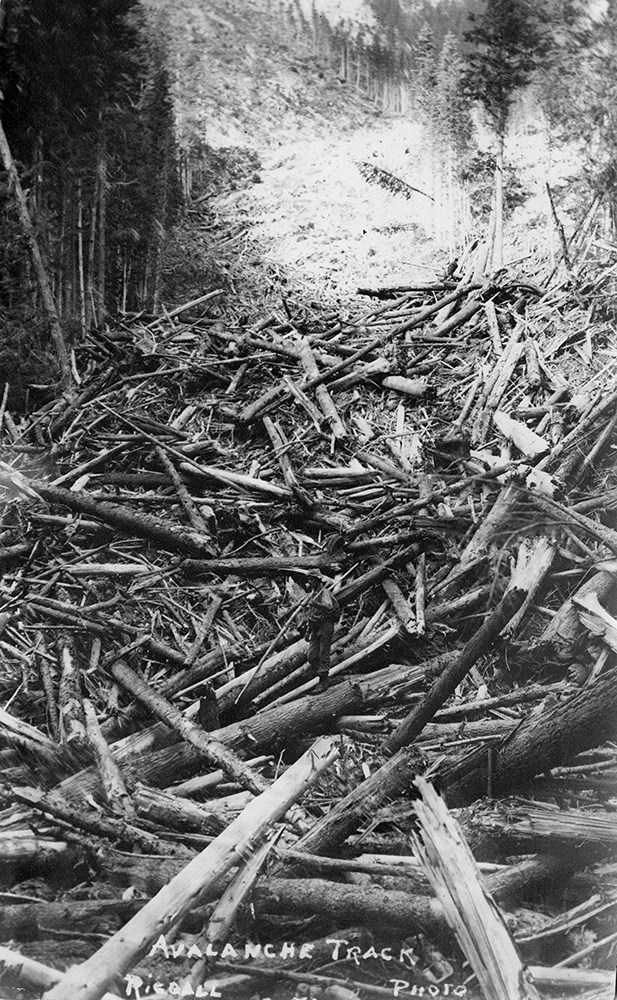
Bert Riggall's 1000 Mile Pack trip
https://archives.whyte.org/en/permalink/descriptions23454
- Part Of
- Bert Riggall fonds
- Scope & Content
- File consists of 43 b&w photographs, some captioned. Photographs pertain to Riggall's 1911 1000 mile pack trip undertaken to seek out areas for hunting and outfitting following the enlargement of Waterton National Park and the reduction of available hunting area for Riggall's clients. The prints do…
- Date Range
- 1911
- Reference Code
- V26 / II / A7 / PA - 119 to 161
- Description Level
- 5 / File
- GMD
- Photograph
- Photograph print
1 image
- Part Of
- Bert Riggall fonds
- Description Level
- 5 / File
- Fonds Number
- M376 / V26
- Series
- II.Business and Financial: Bert Riggall's 1000 Mile Pack trip, 1911
- Sous-Fonds
- V26
- Accession Number
- 7201
- Reference Code
- V26 / II / A7 / PA - 119 to 161
- Date Range
- 1911
- Physical Description
- 43 photographs: b&w prints
- Scope & Content
- File consists of 43 b&w photographs, some captioned. Photographs pertain to Riggall's 1911 1000 mile pack trip undertaken to seek out areas for hunting and outfitting following the enlargement of Waterton National Park and the reduction of available hunting area for Riggall's clients. The prints document this pack trip from stops in Banff, AB and Cranbrook, BC, and the extent of his mountain exploration from Fort Steele to Edson. On this trip, approximately 150 miles of new trail was cut including portions of Roger's Pass.
- Subject Access
- Pack trips
- Exploration
- Trails
- Trail making
- Recreation
- Hunting
- Outfitters, trail guides and packers
- Geographic Access
- Canada
- Alberta
- Banff National Park
- Waterton National Park
- British Columbia
- Cranbrook
- Rogers Pass
- Language
- English
- Title Source
- Title based on contents of file
- Processing Status
- Processed
Images

This material is presented as originally created; it may contain outdated cultural descriptions and
potentially offensive content.
Read more.
Bert Riggall's 1000 Mile Pack trip
https://archives.whyte.org/en/permalink/descriptions23455
- Part Of
- Bert Riggall fonds
- Scope & Content
- File consists of 20 b&w photographs, some captioned. Photographs pertain to Riggall's 1911 1000 mile pack trip undertaken to seek out areas for hunting and outfitting following the enlargement of Waterton National Park and the reduction of available hunting area for Riggall's clients. The prints do…
- Date Range
- 1911
- Reference Code
- V26 / II / A7 / PA - 162 to 181
- Description Level
- 5 / File
- GMD
- Photograph
- Photograph print
1 image
- Part Of
- Bert Riggall fonds
- Description Level
- 5 / File
- Fonds Number
- M376 / V26
- Series
- II.Business and Financial: Bert Riggall's 1000 Mile Pack trip, 1911
- Sous-Fonds
- V26
- Accession Number
- 7201
- Reference Code
- V26 / II / A7 / PA - 162 to 181
- Date Range
- 1911
- Physical Description
- Photographs: 20 prints, b&w
- Scope & Content
- File consists of 20 b&w photographs, some captioned. Photographs pertain to Riggall's 1911 1000 mile pack trip undertaken to seek out areas for hunting and outfitting following the enlargement of Waterton National Park and the reduction of available hunting area for Riggall's clients. The prints document this pack trip from stops in Banff, AB and Cranbrook, BC, and the extent of his mountain exploration from Fort Steele to Edson. On this trip, approximately 150 miles of new trail was cut including portions of Roger's Pass.
- Subject Access
- Pack trips
- Exploration
- Trails
- Trail making
- Recreation
- Hunting
- Outfitters, trail guides and packers
- Geographic Access
- Canada
- Alberta
- Banff National Park
- Waterton National Park
- British Columbia
- Cranbrook
- Rogers Pass
- Language
- English
- Title Source
- Title based on contents of file
- Processing Status
- Processed
Images
This material is presented as originally created; it may contain outdated cultural descriptions and
potentially offensive content.
Read more.
- Part Of
- Dorothy Wardle fonds
- Scope & Content
- File consists of 139 pages of handwritten research notes, correspondence, and newspaper clippings, H35 x W30 cm or smaller. File pertains to Dorothy's research on Banff and surrounding area, Parks Canada, Department of the Interior, and the history of the Canadian Rocky Mountains in general. Record…
- Date Range
- ca. 1870 - ca. 1998
- 1870s-1880s
- ca.1918 - ca. 1960s
- 1986-1998
- 1986
- 1990
- 1993
- 1995
- 1997-1998
- Reference Code
- M521 / I / A / 3-4
- Description Level
- 5 / File
- GMD
- Newspaper clipping
- Private record
- Textual record
- Part Of
- Dorothy Wardle fonds
- Description Level
- 5 / File
- Fonds Number
- M521 / V75
- Series
- M521 / I : Dorothy Wardle Personal Papers
- Sous-Fonds
- M521
- Sub-Series
- M521 / I / A : Research and Writing
- Accession Number
- 7504
- Reference Code
- M521 / I / A / 3-4
- Date Range
- ca. 1870 - ca. 1998
- 1870s-1880s
- ca.1918 - ca. 1960s
- 1986-1998
- 1986
- 1990
- 1993
- 1995
- 1997-1998
- Physical Description
- 2 cm of textual records (139 pages ; 30 x 35 cm or smaller)
- Scope & Content
- File consists of 139 pages of handwritten research notes, correspondence, and newspaper clippings, H35 x W30 cm or smaller. File pertains to Dorothy's research on Banff and surrounding area, Parks Canada, Department of the Interior, and the history of the Canadian Rocky Mountains in general. Records were filed in an envelope that was titled "Book Notes." Notable people include James Wardle, J.B. Harkin, Pat Brewster, Arthur Unwin, Dr. Brett, Norman Sanson, and Bill Peyto, among others. Notable places and topics include the organization of the Department of the Interior, the Banff-Windemere Highway, Rocky Mountain Park and Park Wardens, Kootenay National Park fires, coal and precious metal mines (e.g. Bankhead, Silver City), trail riding and hiking, research about James Wardle and his accomplishments, Ya-Ha-Tinda, and various parks (e.g. Glacier, Revelstoke, Elk Island, Kootenay, and Yoho). Other records include a handwritten letter to the Auld family in Scotland (cousins of Sheila Ritchie) with a story about Glenbow and a highland cow from Oban, Scotland; personal reflections on the Banff area and mountains in general; notes that Dorothy took while doing research at the Whyte Museum of the Canadian Rockies and the Banff Public Library; and a variety of newspaper clippings.
- Notes
- Includes request slips and stationary from the archives at the Whyte Museum.
- Potentially includes a handwritten list of Dorothy's written works.
- Newspaper clippings primarily from the Times Colonist, which is published in Victoria, British Columbia.
- Name Access
- Wardle, Dorothy
- Wardle, James M.
- Harkin, J. B. (James Bernard)
- Brewster, Pat
- Peyto, Bill
- Brett, Robert George
- Sanson, Norman
- Subject Access
- Banff
- Banff National Park
- Banff Public Library
- National parks and reserves
- Newspaper
- Parks Canada
- Park policy
- Research
- Trail Riders of the Canadian Rockies
- Wardens
- Whyte Museum of the Canadian Rockies
- Ya-Ha-Tinda Ranch
- Hiking
- Community life
- History
- Mines and mineral resources
- Geographic Access
- Alberta
- Banff
- Banff National Park
- Bankhead
- British Columbia
- Canada
- Canadian Rocky Mountains
- Castle Mountain
- Glacier National Park
- Kootenay National Park
- Silver City
- Victoria
- Yoho National Park
- Scotland
- Revelstoke
- Language
- English
- Conservation
- Some of the slips of paper are taped together. Was unable to remove them without damaging the materials. May present conservation issues in the future.
- Creator
- Wardle, Dorothy
- Category
- Sports, recreation and leisure
- Transportation
- Politics
- Natural resources
- Family and personal life
- Exploration, discovery and travel
- Title Source
- Title based on contents of file
- Title was written on an envelope containing these materials.
- Processing Status
- Processed
This material is presented as originally created; it may contain outdated cultural descriptions and
potentially offensive content.
Read more.
Canadian history and tourism publications
https://archives.whyte.org/en/permalink/descriptions55109
- Part Of
- Luxton family fonds
- Scope & Content
- File consists of published materials pertaining to topics of Canadian, provincial and regional history, related statistical information, and national politics; information booklets and guides for Banff National Park, Alberta, Victoria, B.C., and other regions within Canada; and other Canadian trave…
- Date Range
- 1902-1905
- 1919
- 1928
- 1930-1931
- 1934
- 1940-1941
- 1948
- 1951
- 1955-1957
- 1960
- 1963
- 1979
- 1988
- Reference Code
- LUX / II / F1 / 63 to 64
- Description Level
- 5 / File
- GMD
- Textual record
- Published record
- Part Of
- Luxton family fonds
- Description Level
- 5 / File
- Fonds Number
- LUX
- Series
- LUX / II / F : Collected material
- Sous-Fonds
- LUX / II : Eleanor Luxton sous-fonds
- Sub-Series
- LUX / II / F1 : Textual
- Accession Number
- LUX
- Reference Code
- LUX / II / F1 / 63 to 64
- Date Range
- 1902-1905
- 1919
- 1928
- 1930-1931
- 1934
- 1940-1941
- 1948
- 1951
- 1955-1957
- 1960
- 1963
- 1979
- 1988
- Physical Description
- 4.5 cm of textual records
- Scope & Content
- File consists of published materials pertaining to topics of Canadian, provincial and regional history, related statistical information, and national politics; information booklets and guides for Banff National Park, Alberta, Victoria, B.C., and other regions within Canada; and other Canadian travel and promotional material.
- Notes
- Some items are annotated
- Subject Access
- Advertising
- Travel
- Tourism
- Transportation
- History
- Geography
- Geographic Access
- Canada
- Alberta
- Banff
- Banff National Park
- British Columbia
- Victoria
- Saskatchewan
- Language
- English
- Category
- Commerce and industry
- Exploration, discovery and travel
- Government
- Natural resources
- Politics
- Sports, recreation and leisure
- Transportation
- Title Source
- Title based on contents of file
- Content Details
- File stored in two folders arranged by subject: LUX / II / F1 / 63 : Canadian history and research material LUX / II / F1 / 64 : Canadian tourism publications
- Processing Status
- Processed
This material is presented as originally created; it may contain outdated cultural descriptions and
potentially offensive content.
Read more.
Cartographic Materials
https://archives.whyte.org/en/permalink/descriptions23065
- Part Of
- Hans Gmoser fonds
- Scope & Content
- Cartographic materials in these four oversized files consist of the following:
- Date Range
- 1914-1973
- Reference Code
- M224 / O.S. Cartographic
- Description Level
- 5 / File
- Part Of
- Hans Gmoser fonds
- Description Level
- 5 / File
- Series
- IV.C. Textual records: Cartographic records
- Accession Number
- 7361, 7877, 8111
- Reference Code
- M224 / O.S. Cartographic
- Date Range
- 1914-1973
- Physical Description
- 48 cartographic records.
- Scope & Content
- Cartographic materials in these four oversized files consist of the following:
- Subject Access
- Discovery and Exploration
- Environment and Nature
- Family and personal life
- Sports and Recreation
- Title Source
- Title based on contents.
- Content Details
- Folder 1 Map on heavy paper, wrapped in plastic. “A Reconnaissance Topographic Map Suveyed and edited by Bradford Washburn” printed in Bern, Switzerland. Centred on Mt. McKinley.- From 7361. Palliser- Kananaskis Area British Columbia and Alberta- Publication No. 1962- Reprinted by the Surveys and Mapping Branch, Department of Mines and Technical Surveys, Ottawa. Mistaya British Columbia and Alberta- Compiled, drawn and printed at the office of the Surveyor General, Ottawa, 1931. Reprinted with corrections at the Surveys and Mapping Branch, Ottawa, 1950. National Topographic Series. Yoho British Columbia and Alberta- Compiled, drawn and printed at the office of the Surveyor General, Ottawa, 1932. Reprinted with corrections at the Surveys and Mapping Branch, Ottawa, 1952. National Topographic Series. Price 25 cents. Invermere British Columbia Kootenay Land District- National Topographic System- First Status Edition compiled and produced by the Geographic Division, Surveys, and Mapping Branch, Dept. of Lands, Forests and Water Resources, Victoria, BC 1964-65- annotated Beaton British Columbia Kootenay Land District- National Topographic System- First Status Edition compiled and produced by the Geographic Division, Surveys, and Mapping Branch, Dept. of Lands, Forests and Water Resources, Victoria, BC 1964-66- annotated Lardeau British Columbia Kootenay Land District- National Topographic System- First Status Edition compiled and produced by the Geographic Division, Surveys, and Mapping Branch, Dept. of Lands, Forests and Water Resources, Victoria, BC 1963- annotated Mount McKinley Alaska, Published by the Museum of Science, Boston, Mass, USA and the Swiss Foundation for Alpine Research, Zurich. 1960. Centennial Range Yukon Territory- M.C.R. 7 Edition 1- Produced and printed 1967 by the Surveys and Mapping Branch, Department of Energy, Mines and Resources- maps printed in 1961-62- annotated British Columbia Land Recording Dists.- Land Commissioner’s Offices- Department of Lands and Forests- first published 1957- Updated Nov. 1, 1960. Master Site Plan Bugaboo Creek Lodge Project number 6844- June 18, 1973- Cohos Delesalle & Evamy. Folder 2 Boundary Between Alberta and BC- Athabasca Pass- Sheet No. 27A – annotated- centered on Jasper Park Boundary Between Alberta and BC-All below Wheeler Maps (by hand) used for the Great Divide as per Chic-no topographical maps used for both Hans and similar maps were used by Chic bottom rip taped- Sheet No. 20- Drawn and printed by the Topographical Survey of Canada, Ottawa - centered on Clearwater forest and Lyell Icefield at bottom right Boundary Between Alberta and BC- Sheet No. 15- Drawn and printed at the Surveyor General’s Office, Ottawa, Canada- centered on Rocky Mountains Park Boundary Between Alberta and BC - Sheet No. 19- Drawn and printed at the Surveyor General’s Office, Ottawa, Canada- centered on centered on Clearwater Forest with Mt. Alan Campbell at bottom Boundary Between Alberta and BC- Sheet No. 25- annotated- Drawn and printed by the Topographical Survey of Canada, Ottawa - centered on Jasper Park with Chisel Peak at bottom Boundary Between Alberta and BC- Sheet No. 19- dirt and annotated- revised 1925- drawn and printed by the Topographical Survey of Canada, Ottawa- centered on Clearwater and Push Pass W. Boundary Between Alberta and BC- annotated- Sheet 16- revised 1925- drawn and printed by the Topographical Survey of Canada, Ottawa- centered on Yoho Park and Rocky Mountains Park Steele Glacier- Topographical Survey 1967 Arial Photography 1951 Mount St. Elias Canada- United State of America- Produced and Printed by the Surveys and Mapping Branch, Department of Mines and Technical Surveys 1962 from air photographs taken in 1951 and 1956- annotated Woolsey Glacier- Revelstoke National Park British Columbia – Printed by the Surveys and Mapping Branch Department of Energy, Mines and Resources- 1967 Windermere Kootenay District- Map 165A Issued 1918- Reprinted by the Surveys and Mapping Branch, Department of Mines and Technical Surveys, Ottawa. Folder 3 Boundary Between Alberta and BC- Sheet No. 20- heavily annotated- revised 1925- drawn and printed by the Topographical Survey of Canada, Ottawa- centered on Clearwater Forest, Saskatchewan Glacier at top left Boundary Between Alberta and BC- Sheet No. 18- heavily ripped- annotated - notes on back- revised 1925- drawn and printed by the Topographical Survey of Canada, Ottawa- centered on Clearwater Forest, Mt Mummery at bottom Boundary Between Alberta and BC- Sheet No. 17 (in pencil “A and B”)- annotated - heavily ripped- drawn and printed at the Surveyor Generals’ Office- centered on Clearwater Forest and Yoho Park Boundary Between Alberta and BC- Sheet No. 26- annotated- revised 1925- drawn and printed by the Topographical Survey of Canada, Ottawa- centered on Jasper Park and Icefields Boundary Between Alberta and BC- Sheet No. 17- revised 1925- drawn and printed by the Topographical Survey of Canada, Ottawa- centered on Clearwater Forest and Yoho Park Boundary Between Alberta and BC- Sheet No. 28- stained- centered on Jasper Park Boundary Between Alberta and BC- Sheet No. 24- annotated- revised edition, 1925- drawn and printed by the Topographical Survey of Canada, Ottawa- centered on Jasper Park Boundary Between Alberta and BC- Sheet No. 16- annotated- revised 1925- drawn and printed by the Topographical Survey of Canada, Ottawa- centered on Yoho and Rocky Mountains Park Interprovincial Boundary Commission Boundary Between Alberta and British Columbia. Revised edition 1925 drawn and printed by the Topographical Survey of Canada, Ottawa. Sheet No. 27. Following maps are from accession 7877. Interprovincial Boundary Commission Boundary Between Alberta and British Columbia. Surveyed 1920. Drawn and printed by the Topographical Survey of Canada, Ottawa. Sheet No. 26. Interprovincial Boundary Commission Boundary Between Alberta and British Columbia. Surveyed 1920, 1921. Drawn and printed by the Topographical Survey of Canada, Ottawa. Sheet No. 25. Interprovincial Boundary Commission Boundary Between Alberta and British Columbia. Surveyed 1919, 1921. Drawn and printed by the Topographical Survey of Canada, Ottawa. Sheet No. 24. Interprovincial Boundary Commission Boundary Between Alberta and British Columbia. Revised edition 1925 drawn and printed by the Topographical Survey of Canada, Ottawa. Sheet No. 21. Interprovincial Boundary Commission Boundary Between Alberta and British Columbia. Revised edition 1925 drawn and printed by the Topographical Survey of Canada, Ottawa. Sheet No. 18. Interprovincial Boundary Commission Boundary Between Alberta and British Columbia. Surveyed 1913. Drawn and printed by the Topographical Survey of Canada, Ottawa. Sheet No. 13 A. Interprovincial Boundary Commission Boundary Between Alberta and British Columbia. Surveyed 1916. Drawn and printed by the Topographical Survey of Canada, Ottawa. Sheet No. 12 A. Interprovincial Boundary Commission Boundary Between Alberta and British Columbia. Surveyed 1916. Drawn and printed by the Topographical Survey of Canada, Ottawa. Sheet No. 11. Interprovincial Boundary Commission Boundary Between Alberta and British Columbia. Surveyed 1916. Drawn and printed by the Topographical Survey of Canada, Ottawa. Sheet No. 10. Interprovincial Boundary Commission Boundary Between Alberta and British Columbia. Surveyed 1916. Drawn and printed by the Topographical Survey of Canada, Ottawa. Sheet No. 9. Interprovincial Boundary Commission Boundary Between Alberta and British Columbia. Surveyed 1916. Drawn and printed by the Topographical Survey of Canada, Ottawa. Sheet No. 8. Interprovincial Boundary Commission Boundary Between Alberta and British Columbia. Surveyed 1916. Drawn and printed by the Topographical Survey of Canada, Ottawa. Sheet No. 6. Interprovincial Boundary Commission Boundary Between Alberta and British Columbia. Surveyed 1915. Drawn and printed by the Topographical Survey of Canada, Ottawa. Sheet No. 5. Interprovincial Boundary Commission Boundary Between Alberta and British Columbia. Surveyed 1914. Drawn and printed by the Topographical Survey of Canada, Ottawa. Sheet No. 4. Interprovincial Boundary Commission Boundary Between Alberta and British Columbia. Surveyed 1922. Drawn and printed by the Topographical Survey of Canada, Ottawa. Sheet No. 31. Interprovincial Boundary Commission Boundary Between Alberta and British Columbia. Surveyed 1922, 1924. Drawn and printed by the Topographical Survey of Canada, Ottawa. Sheet No. 30. Interprovincial Boundary Commission Boundary Between Alberta and British Columbia. Surveyed 1917. Drawn and printed by the Topographical Survey of Canada, Ottawa. Sheet No. 29.
- Processing Status
- Processed
This material is presented as originally created; it may contain outdated cultural descriptions and
potentially offensive content.
Read more.
Climbers on glacier, Robson
https://archives.whyte.org/en/permalink/descriptions27404
- Part Of
- Byron Harmon fonds
- Scope & Content
- Robson Glacier?
- Date Range
- [1913 or 1918]
- Reference Code
- V263 / NA - 935
- Description Level
- 6 / Item
- GMD
- Photograph
- Negative
1 image
- Part Of
- Byron Harmon fonds
- Description Level
- 6 / Item
- Fonds Number
- V263
- Series
- I. Scenic / commercial series
- Sub-Series
- A.1.a. Negatives, Main series : 13 x 18 cm and smaller
- Reference Code
- V263 / NA - 935
- GMD
- Photograph
- Negative
- Date Range
- [1913 or 1918]
- Physical Description
- 1 photograph : negative, 13 x 18 cm or smaller
- Scope & Content
- Robson Glacier?
- Subject Access
- Discovery and Exploration
- Environment and Nature
- Sports and Recreation
- Geographic Access
- British Columbia
- Conservation
- Reprocessed / archival quality gold-toned, 1973
- Creator
- Byron Harmon (Banff, Alberta)
Images

This material is presented as originally created; it may contain outdated cultural descriptions and
potentially offensive content.
Read more.
Collected materials, commercial postcards
https://archives.whyte.org/en/permalink/descriptions54600
- Part Of
- Kidney family fonds
- Scope & Content
- File consists of 41 commercial postcards, mostly produced in Banff by Byron Harmon. Content pertains to Banff and the Canadian Rockies; sports including snowshoeing, hiking, curling and boating; landscapes nd mountain views; multiple hotels in and near Banff [the Banff Springs Hotel, Chateau Lake L…
- Date Range
- [ca. 1905 - ca. 1910]
- 1912
- 1915
- [ca. 1920]
- [ca. 1930 - ca. 1940]
- [ca. 1960]
- Reference Code
- V324 / VI / PG - 1 to 41
- Description Level
- 5 / File
- GMD
- Postcard
- Part Of
- Kidney family fonds
- Description Level
- 5 / File
- Fonds Number
- M74 / V324
- Series
- V324 / VI : Collected materials
- Sous-Fonds
- V324
- Accession Number
- 2016.8581
- Reference Code
- V324 / VI / PG - 1 to 41
- GMD
- Postcard
- Responsibility
- Produced by Byron Harmon, Canadian Postcard Co. Ltd., Valentine - Black Co. Ltd, G & W Fear Photographers, Dexter Press Inc.
- Date Range
- [ca. 1905 - ca. 1910]
- 1912
- 1915
- [ca. 1920]
- [ca. 1930 - ca. 1940]
- [ca. 1960]
- Physical Description
- 41 postcards : b&w and col. ; 10 x 14.5 cm and 9 x 14 cm
- Scope & Content
- File consists of 41 commercial postcards, mostly produced in Banff by Byron Harmon. Content pertains to Banff and the Canadian Rockies; sports including snowshoeing, hiking, curling and boating; landscapes nd mountain views; multiple hotels in and near Banff [the Banff Springs Hotel, Chateau Lake Louise, Cascade Hotel and Mount Royal Hotel]; Banff's fish hatchery; hoodoo rock formations; animals at the Banff Zoo including bears and buffalo, and other local wildlife; the Cave and Basin; a military base camp in Petawawa, Ontario where Forest Kidney was stationed in World War I; and the Bank of Commerce building in Toronto.
- Notes
- Some dates are estimates provided by the Processing Archivist
- Name Access
- Harmon, Byron
- Kidney, Forest H. (Pop)
- Subject Access
- Mountain
- Hiking
- Sports
- Winter sports
- Curling
- Snowshoes and snowshoeing
- Hotel
- Banff Spring Hotel
- Chateau Lake Louise
- Cascade Hotel
- Mount Royal Hotel
- Swimming
- Hot Springs
- Landscapes
- Boats
- Geological formation
- Animals
- Buffalo
- Bear
- Train
- Travel
- World War I
- Military
- Geographic Access
- Canada
- Alberta
- Banff
- Cave and Basin
- Robson Glacier
- Bankhead
- Lake Louise
- British Columbia
- Field
- Bow River
- Castle Mountain
- Mount Rundle
- France
- Arras
- Ontario
- Petawawa
- Toronto
- Access Restrictions
- Restrictions may apply
- Reproduction Restrictions
- Restrictions may apply
- Language
- English
- Conservation
- One item with adhesive stains on back has been placed in mylar to protect adjacent items
- Title Source
- Title based on contents of file
- Processing Status
- Processed
This material is presented as originally created; it may contain outdated cultural descriptions and
potentially offensive content.
Read more.