Narrow Results By
[Adams River 82M/11 East, B.C.]
https://archives.whyte.org/en/permalink/catalogue23443
- Medium
- Library - Maps and blueprints (unannotated; published)
- Map
- Published Date
- 1961
- Publisher
- Dept. of Mines and Technical Surveys
- Call Number
- NTS
- 82M/11E
- Publisher
- Dept. of Mines and Technical Surveys
- Published Date
- 1961
- Physical Description
- 1 map : col
- Scale
- Scale: 1:50,000
- Relief: Contour interval 100 ft.
- Subjects
- Adams River
- British Columbia
- Notes
- National Topographic System
- Accession Number
- 3000
- Call Number
- NTS
- 82M/11E
- Collection
- Archives Library
This material is presented as originally created; it may contain outdated cultural descriptions and
potentially offensive content.
Read more.
[Adams River 82M/11 West, B.C.]
https://archives.whyte.org/en/permalink/catalogue23444
- Medium
- Library - Maps and blueprints (unannotated; published)
- Map
- Published Date
- 1961
- Publisher
- Dept. of Mines and Technical Surveys
- Call Number
- NTS
- 82M/11W
- Publisher
- Dept. of Mines and Technical Surveys
- Published Date
- 1961
- Physical Description
- 1 map : col
- Scale
- Scale: 1:50,000
- Relief: Contour interval 100 ft.
- Subjects
- Adams River
- British Columbia
- Notes
- National Topographic System
- Accession Number
- 3000
- Call Number
- NTS
- 82M/11W
- Collection
- Archives Library
This material is presented as originally created; it may contain outdated cultural descriptions and
potentially offensive content.
Read more.
[Alsek River 114 NE, B.C.-Alaska]
https://archives.whyte.org/en/permalink/catalogue24174
- Medium
- Library - Maps and blueprints (unannotated; published)
- Map
- Published Date
- 1965
- Publisher
- Dept. of Mines and Technical Surveys
- Call Number
- NTS
- 114NE
- Publisher
- Dept. of Mines and Technical Surveys
- Published Date
- 1965
- Scale
- Scale: 1:500,000
- Altitude tints
- Subjects
- Alsek River
- British Columbia/Alaska
- Notes
- National Topographic System
- Accession Number
- 3000
- Call Number
- NTS
- 114NE
- Collection
- Archives Library
This material is presented as originally created; it may contain outdated cultural descriptions and
potentially offensive content.
Read more.
[Athabaska River]
https://archives.whyte.org/en/permalink/catalogue24216
- Medium
- Library - Maps and blueprints (unannotated; published)
- Map
- Published Date
- 1964
- Publisher
- Department of Mines & Technical Surveys
- Call Number
- NTS
- 83
- Publisher
- Department of Mines & Technical Surveys
- Published Date
- 1964
- Physical Description
- 1 map : col
- Scale
- Scale: 1:1,000,000
- Relief: Altitude tints
- Subjects
- Athabaska River
- Accession Number
- 3000
- Call Number
- NTS
- 83
- Collection
- Archives Library
This material is presented as originally created; it may contain outdated cultural descriptions and
potentially offensive content.
Read more.
Banff and area businesses, townsite, scenic views
https://archives.whyte.org/en/permalink/descriptions55024
- Part Of
- Luxton family fonds
- Scope & Content
- File consists of photographs pertaining to businesses, tourist attractions and natural views in and around Banff. Includes images of backcountry camps in Banff National Park; the Bow River Boat House; Beaver Lodge and Bampton Cottage [both located on Beaver Street in Banff]; fires at Breton Hall Ho…
- Date Range
- [ca.1890-1900]
- [1896-1898]
- 1904-1905
- [ca.1910-1920]
- 1912
- 1914
- [ca.1930-1935]
- 1933
- 1941
- [ca.1950-1960]
- Reference Code
- LUX / I / D6c / PA - 133 to 182
- Description Level
- 5 / File
- GMD
- Photograph
- Photograph print
1 image
- Part Of
- Luxton family fonds
- Description Level
- 5 / File
- Fonds Number
- LUX
- Series
- LUX / I / D : Professional and Personal
- Sous-Fonds
- LUX / I : Norman Luxton sous-fonds
- Sub-Series
- LUX / I / D6 : Other activities and interests
- Accession Number
- LUX
- Reference Code
- LUX / I / D6c / PA - 133 to 182
- Responsibility
- PA-182 produced by Canadian Pacific
- Date Range
- [ca.1890-1900]
- [1896-1898]
- 1904-1905
- [ca.1910-1920]
- 1912
- 1914
- [ca.1930-1935]
- 1933
- 1941
- [ca.1950-1960]
- Physical Description
- 50 photographs ; b&w prints ; 25 x 20.5 cm or smaller
- Scope & Content
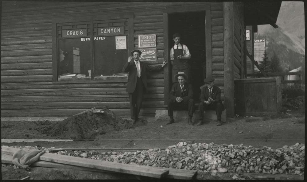
- File consists of photographs pertaining to businesses, tourist attractions and natural views in and around Banff. Includes images of backcountry camps in Banff National Park; the Bow River Boat House; Beaver Lodge and Bampton Cottage [both located on Beaver Street in Banff]; fires at Breton Hall Hotel and Banff Springs Hotel; the Park Museum and Information Bureau; early views of Banff Springs Hotel [1904]; Vermillion River Bungalow Camp and the Lake Louise Chalet; Paddy J. Nolan’s home [built by Norman Luxton]; a postcard print titled “Starved Bachelors Retreat Banff Alberta"; swimming at the Cave and Basin[?] and Banff Upper Hot Springs; the Crag and Canyon office [ca.1905]; Skoki Lodge; and the office of photographers Wilson and Fear [1896-1898].
- Notes
- Photographs LUX/I/D6c/PA-181 and 182 [depicting Wilson and Fear storefront] are copies of the same image but annotated with different dates [ca.1896 and ca.1898]. Based on context and dating of related images in Whyte Museum archives, actual image date may be closer to [ca.1894].
- Material Details
- LUX/I/D6c/PA-173 has three red sun-shaped stickers attached to back left corner, red ribbon attached to back right corner
- Name Access
- Wilson, John
- Fear, George
- Fear, William (Bill)
- Nolan, Paddy J.
- Luxton, Norman
- Smyth, S. A.
- Subject Access
- Bow River Boat House
- Pack trips
- Horses
- Teepees
- Boats
- Property
- Land use
- Hotels
- Fire
- Banff Springs Hotel
- Photography
- Businesses
- Tourism
- Hot Springs
- Leisure
- Mountain
- Newspaper
- Organizations
- Travel
- Geographic Access
- Canada
- Alberta
- Banff
- Banff National Park
- Vermilion Lakes
- Lake Louise
- Bow River
- Sulphur Mountain
- Cave and Basin
- Language
- English
- Related Material
- Items LUX/I/D6c/PA-163 to 168 have duplicate negative copies processed as LUX/I/D6c/NA-41 to 46
- Title Source
- Title based on contents of file
- Processing Status
- Processed
Images
This material is presented as originally created; it may contain outdated cultural descriptions and
potentially offensive content.
Read more.
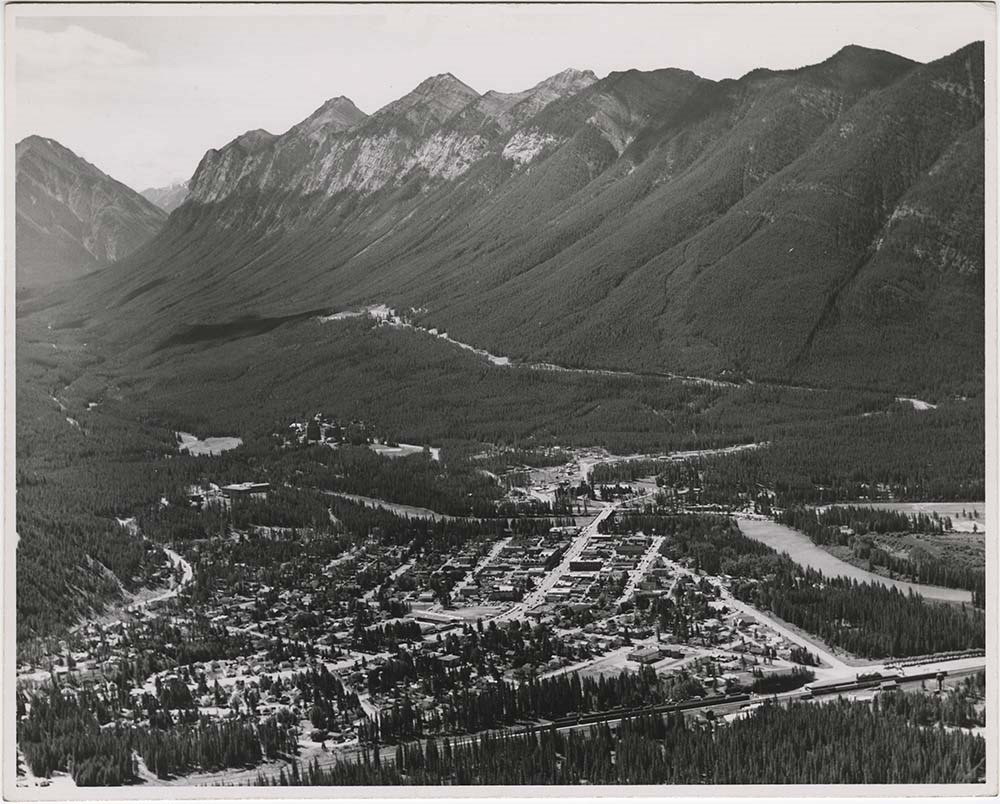
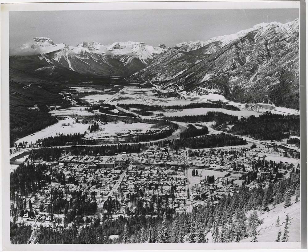
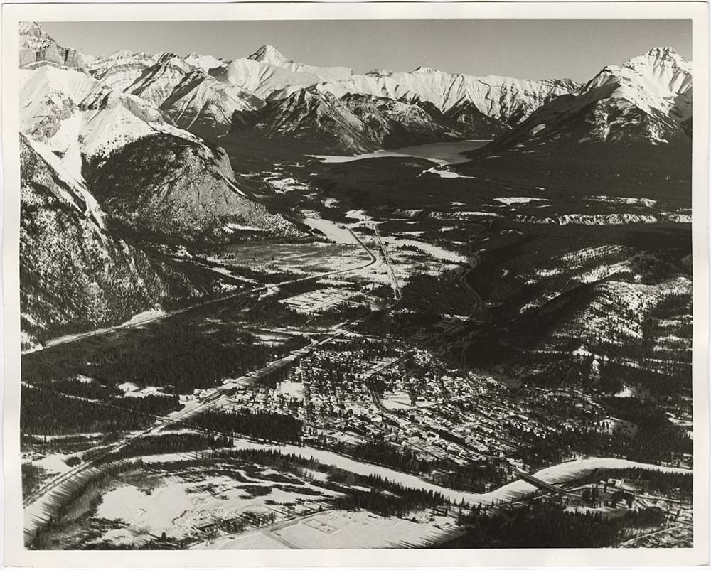
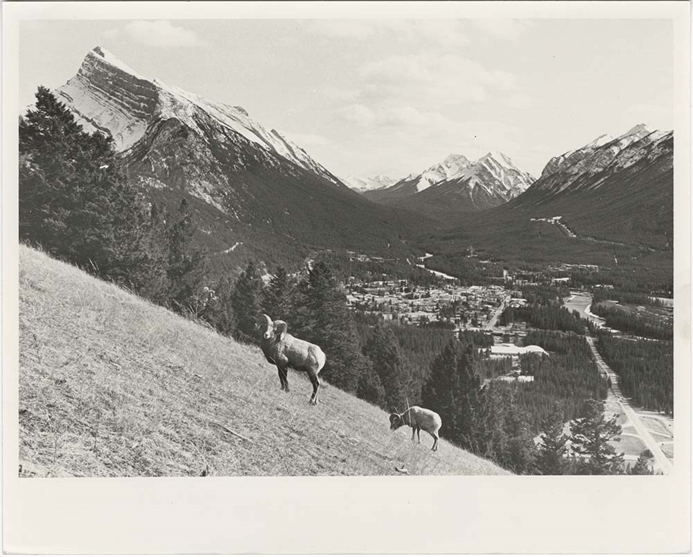
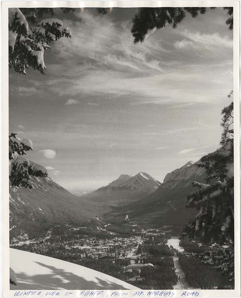
Banff Townsite
https://archives.whyte.org/en/permalink/descriptions57483
- Part Of
- Bruno Engler fonds
- Scope & Content
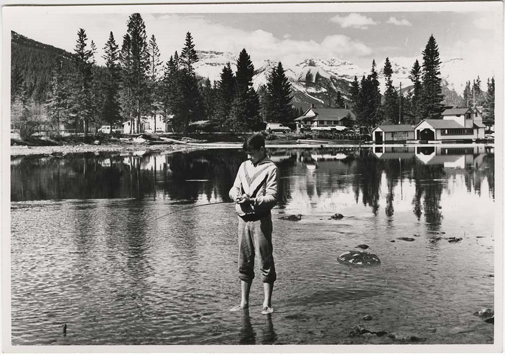
- File pertains to 30 b&w & colour prints of the Banff townsite from various angles, usually from Mount Norquay and Tunnel Mountain. Also includes shots of people at the opening of the Banff Upper Hot Springs, fishing in the river, and painting at Vermillion Lakes.
- Date Range
- 1959-1983
- Reference Code
- V190 / VI / B / ix / PA - 01 to PA - 30
- Description Level
- 5 / File
- GMD
- Photograph
11 images
- Part Of
- Bruno Engler fonds
- Description Level
- 5 / File
- Fonds Number
- M323 / S40 / V190
- Series
- VI : Retained file, B : Alphabetical order
- Sous-Fonds
- V190
- Sub-Series
- ix : Banff Townsite
- Accession Number
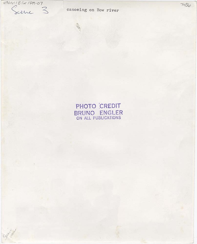
- 7436
- Reference Code
- V190 / VI / B / ix / PA - 01 to PA - 30
- GMD
- Photograph
- Date Range
- 1959-1983
- Physical Description
- 30 photographs : b&w & col. ; 25.2 x 20.2 cm or smaller
- History / Biographical
- See fonds level description
- Scope & Content
- File pertains to 30 b&w & colour prints of the Banff townsite from various angles, usually from Mount Norquay and Tunnel Mountain. Also includes shots of people at the opening of the Banff Upper Hot Springs, fishing in the river, and painting at Vermillion Lakes.
- Subject Access
- Activities
- Animals
- Aerial photography
- Artist
- Banff townsite
- Banff Upper Hot Springs
- Big Horn Sheep
- Bow River
- Bow River Boat House
- Buildings
- Fishing
- Mountains
- scenic
- Winter
- Geographic Access
- Banff
- Banff National Park
- Alberta
- Language
- English
- Creator
- Engler, Bruno
- Title Source
- Original title kept
- Processing Status
- Processed
Images


This material is presented as originally created; it may contain outdated cultural descriptions and
potentially offensive content.
Read more.
Banff Winter Carnival
https://archives.whyte.org/en/permalink/descriptions55750
- Part Of
- William Royle fonds
- Scope & Content
- File pertains to 74 colour 35mm slides of Banff Winter Carnival events, possibly from multiple years. Includes parade floats, ice sculptures, Ice Pinnacles on the Bow River, and scenes of a large crowd - possibly part of opening or closing ceremonies.
- Date Range
- [ca. 1960-1970]
- Reference Code
- V808 / III / NS - 69 to NS - 142
- Description Level
- 5 / File
- GMD
- Photograph
- Transparency
- Part Of
- William Royle fonds
- Description Level
- 5 / File
- Fonds Number
- M587 / V808
- Series
- II. Transparencies
- Sous-Fonds
- V808
- Accession Number
- 2021.29
- Reference Code
- V808 / III / NS - 69 to NS - 142
- Date Range
- [ca. 1960-1970]
- Physical Description
- 74 photographs : col. slides ; 35 mm
- History / Biographical
- See fonds level description
- Scope & Content
- File pertains to 74 colour 35mm slides of Banff Winter Carnival events, possibly from multiple years. Includes parade floats, ice sculptures, Ice Pinnacles on the Bow River, and scenes of a large crowd - possibly part of opening or closing ceremonies.
- Notes
- Slides are sectioned into series, noted by stamped numbers in one corner of the cardboard mounts - some appear to be curated by Royle and are denoted with ink dots.
- Subject Access
- Automobiles
- Banff Winter Carnival
- Banff townsite
- Bow River
- Buildings
- Businesses
- Community events
- Events
- Ice sculpture
- Mountains
- Parade
- Winter
- Winter Carnival
- Geographic Access
- Banff
- Banff National Park
- Alberta
- Language
- English
- Conservation
- Rehoused from original cardboard and plastic boxes
- Title Source
- Title based on contents of file
- Processing Status
- Processed
This material is presented as originally created; it may contain outdated cultural descriptions and
potentially offensive content.
Read more.
Belly River near Monarch, Alberta
https://archives.whyte.org/en/permalink/artifactwbg.04.110
- Date
- 1967
- Medium
- ink on paper
- Catalogue Number
- WbG.04.110
- Description
- Belly River in foreground.
- Title
- Belly River near Monarch, Alberta
- Date
- 1967
- Medium
- ink on paper
- Dimensions
- 43.2 x 58.5 cm
- Description
- Belly River in foreground.
- Subject
- landscape
- Southern Alberta
- Belly River
- Credit
- Gift of Donna Tingley, Edmonton, 2004
- Catalogue Number
- WbG.04.110
This material is presented as originally created; it may contain outdated cultural descriptions and
potentially offensive content.
Read more.
[Blaeberry River 82N/10 East, B.C.-Alberta]
https://archives.whyte.org/en/permalink/catalogue23499
- Medium
- Library - Maps and blueprints (unannotated; published)
- Map
- Published Date
- 1963
- Publisher
- Dept of Mines and Techinical Surveys
- Call Number
- NTS
- 82N/10E
- Publisher
- Dept of Mines and Techinical Surveys
- Published Date
- 1963
- Physical Description
- 1 map : col
- Scale
- Scale: 1:50,000
- Relief: Contour interval 100'
- Notes
- National Topographic System
- Call Number
- NTS
- 82N/10E
- Collection
- Archives Library
This material is presented as originally created; it may contain outdated cultural descriptions and
potentially offensive content.
Read more.
[Blaeberry River 82N/10 West, B.C.-Alberta]
https://archives.whyte.org/en/permalink/catalogue23500
- Medium
- Library - Maps and blueprints (unannotated; published)
- Map
- Published Date
- 1963
- Publisher
- Dept. of Mines and Techinical Surveys
- Call Number
- NTS
- 82N/10W
- Publisher
- Dept. of Mines and Techinical Surveys
- Published Date
- 1963
- Physical Description
- 1 map : col
- Scale
- Scale: 1:50,000
- Notes
- 2 duplicates
- National Topographic System
- Accession Number
- 7030
- 6283
- Call Number
- NTS
- 82N/10W
- Collection
- Archives Library
This material is presented as originally created; it may contain outdated cultural descriptions and
potentially offensive content.
Read more.