Narrow Results By
- Ernest C. W Lamarque (1879 – 1970, Canadian) 26
- John Hartman (1950 – , Canadian) 6
- James (Sr.) Simpson (1877 – 1972, Canadian) 3
- Alfred Crocker Leighton, R. C. A. (1901 – 1965, Canadian) 2
- C. Firth 2
- Walter Joseph Phillips, R. C. A. (1884 – 1963, Canadian) 2
- Catherine Perehudoff Fowler (1958 – , Canadian) 1
- Charles Jones Way (1835 – 1919, British) 1
- Dorothy Elsie Knowles Perehudoff (1927 – 2023, Canadian) 1
- Marmaduke Matthews (1837 – 1913, British) 1
- Mary Augusta Catharine Heister Reid (1854 – 1921, American, Canadian) 1
- Peter Whyte (1905 – 1966, Canadian) 1
AAF aeronautical chart : North Saskatchewan River / compiled for the U.S. Army Air Forces by the U.S. Coast and Geodetic Survey
https://archives.whyte.org/en/permalink/catalogue24364
- Medium
- Library - Maps and blueprints (unannotated; published)
- Map
- Published Date
- 1943
- Publisher
- Washington, D.C.
- Call Number
- C6-12.1
- Publisher
- Washington, D.C.
- Published Date
- 1943
- Physical Description
- 1 map : col
- Scale
- 1 : 1,000,000
- Subjects
- Saskatchewan River, North
- Aviation
- Accession Number
- 4008
- Call Number
- C6-12.1
- Collection
- Archives Library
This material is presented as originally created; it may contain outdated cultural descriptions and
potentially offensive content.
Read more.
[Adams River 82M/11 East, B.C.]
https://archives.whyte.org/en/permalink/catalogue23443
- Medium
- Library - Maps and blueprints (unannotated; published)
- Map
- Published Date
- 1961
- Publisher
- Dept. of Mines and Technical Surveys
- Call Number
- NTS
- 82M/11E
- Publisher
- Dept. of Mines and Technical Surveys
- Published Date
- 1961
- Physical Description
- 1 map : col
- Scale
- Scale: 1:50,000
- Relief: Contour interval 100 ft.
- Subjects
- Adams River
- British Columbia
- Notes
- National Topographic System
- Accession Number
- 3000
- Call Number
- NTS
- 82M/11E
- Collection
- Archives Library
This material is presented as originally created; it may contain outdated cultural descriptions and
potentially offensive content.
Read more.
[Adams River 82M/11 West, B.C.]
https://archives.whyte.org/en/permalink/catalogue23444
- Medium
- Library - Maps and blueprints (unannotated; published)
- Map
- Published Date
- 1961
- Publisher
- Dept. of Mines and Technical Surveys
- Call Number
- NTS
- 82M/11W
- Publisher
- Dept. of Mines and Technical Surveys
- Published Date
- 1961
- Physical Description
- 1 map : col
- Scale
- Scale: 1:50,000
- Relief: Contour interval 100 ft.
- Subjects
- Adams River
- British Columbia
- Notes
- National Topographic System
- Accession Number
- 3000
- Call Number
- NTS
- 82M/11W
- Collection
- Archives Library
This material is presented as originally created; it may contain outdated cultural descriptions and
potentially offensive content.
Read more.
Alberta : Athabaska sheet
https://archives.whyte.org/en/permalink/catalogue24415
- Medium
- Library - Maps and blueprints (unannotated; published)
- Map
- Published Date
- 1914
- Publisher
- Ottawa: Office of the Surveyor General
- Edition
- 2d ed.
- Call Number
- C9-2.4
- Edition
- 2d ed.
- Publisher
- Ottawa: Office of the Surveyor General
- Published Date
- 1914
- Physical Description
- 1 map
- Scale
- Scale: 1:190,080
- Subjects
- Athabaska River
- Notes
- Sectional map
- Accession Number
- 5576
- 4008
- Call Number
- C9-2.4
- Collection
- Archives Library
This material is presented as originally created; it may contain outdated cultural descriptions and
potentially offensive content.
Read more.
[Alsek River 114 NE, B.C.-Alaska]
https://archives.whyte.org/en/permalink/catalogue24174
- Medium
- Library - Maps and blueprints (unannotated; published)
- Map
- Published Date
- 1965
- Publisher
- Dept. of Mines and Technical Surveys
- Call Number
- NTS
- 114NE
- Publisher
- Dept. of Mines and Technical Surveys
- Published Date
- 1965
- Scale
- Scale: 1:500,000
- Altitude tints
- Subjects
- Alsek River
- British Columbia/Alaska
- Notes
- National Topographic System
- Accession Number
- 3000
- Call Number
- NTS
- 114NE
- Collection
- Archives Library
This material is presented as originally created; it may contain outdated cultural descriptions and
potentially offensive content.
Read more.
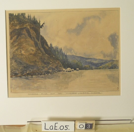
Athabasca River near Fort McMurray
https://archives.whyte.org/en/permalink/artifactlae.05.03
- Date
- 1930
- Medium
- watercolour on paper
- Catalogue Number
- LaE.05.03
- Description
- General colour: dark grey with blue and green on white. The river takes up lower third. A steep cliff rises up on the left side; there are trees on top. Blue hills can be seen in the distance on the right; trees diminish on both sides of the river. Cloudy sky above.
1 image
- Title
- Athabasca River near Fort McMurray
- Date
- 1930
- Medium
- watercolour on paper
- Dimensions
- 21.2 x 29.0 cm
- Description
- General colour: dark grey with blue and green on white. The river takes up lower third. A steep cliff rises up on the left side; there are trees on top. Blue hills can be seen in the distance on the right; trees diminish on both sides of the river. Cloudy sky above.
- Subject
- landscape
- river, Athabasca
- Ernest Lamarque
- Credit
- Gift of Ernest Lamarque (Estate), 1971
- Catalogue Number
- LaE.05.03
Images
This material is presented as originally created; it may contain outdated cultural descriptions and
potentially offensive content.
Read more.
[Athabaska River]
https://archives.whyte.org/en/permalink/catalogue24216
- Medium
- Library - Maps and blueprints (unannotated; published)
- Map
- Published Date
- 1964
- Publisher
- Department of Mines & Technical Surveys
- Call Number
- NTS
- 83
- Publisher
- Department of Mines & Technical Surveys
- Published Date
- 1964
- Physical Description
- 1 map : col
- Scale
- Scale: 1:1,000,000
- Relief: Altitude tints
- Subjects
- Athabaska River
- Accession Number
- 3000
- Call Number
- NTS
- 83
- Collection
- Archives Library
This material is presented as originally created; it may contain outdated cultural descriptions and
potentially offensive content.
Read more.
[Azure River 83D/12 B.C.]
https://archives.whyte.org/en/permalink/catalogue23458
- Medium
- Library - Maps and blueprints (unannotated; published)
- Map
- Published Date
- 1972
- Publisher
- Department of Energy, Mines and Resources
- Call Number
- NTS
- 83D/12
- Publisher
- Department of Energy, Mines and Resources
- Published Date
- 1972
- Physical Description
- 1 map : col
- Scale
- Scale: 1:50,000
- Relief: Contour interval 100 ft.
- Subjects
- Azure River
- British Columbia
- Notes
- National Topographic System
- Accession Number
- 7000
- 7030
- Call Number
- NTS
- 83D/12
- Collection
- Archives Library
This material is presented as originally created; it may contain outdated cultural descriptions and
potentially offensive content.
Read more.
Azure River 83D/12 B.C.
https://archives.whyte.org/en/permalink/catalogue23459
- Medium
- Library - Maps and blueprints (unannotated; published)
- Map
- Published Date
- 1986
- Publisher
- Surveys and Mapping Branch, Dept. of Energy, Mines and Resources
- Edition
- 3rd ed.
- Call Number
- NTS
- 83D/12
- Edition
- 3rd ed.
- Publisher
- Surveys and Mapping Branch, Dept. of Energy, Mines and Resources
- Published Date
- 1986
- Physical Description
- 1 map : col
- Scale
- Scale: 1:50,000
- Relief: Contour interval 100 feet.
- Subjects
- Azure River
- British Columbia
- Notes
- National Topographic System
- Accession Number
- 19,000
- Call Number
- NTS
- 83D/12
- Collection
- Archives Library
This material is presented as originally created; it may contain outdated cultural descriptions and
potentially offensive content.
Read more.
Banff Springs Hotel, Rocky Mountains 1887
https://archives.whyte.org/en/permalink/artifactfic.05.01
- Artist
- C. Firth
- Date
- 1887
- Medium
- watercolour on paper
- Catalogue Number
- FiC.05.01
- Description
- Scene showing Banff springs hotel at right perched on a hillside. In the background the Bow River winds through a valley between Tunnel Mountain and Mt. Roundly. More mountains in distance. Trees in foreground. My. Roundly is hazy, almost unfinished in appearance.
1 image
- Artist
- C. Firth
- Title
- Banff Springs Hotel, Rocky Mountains 1887
- Date
- 1887
- Medium
- watercolour on paper
- Dimensions
- 12.0 x 16.0 cm
- Description
- Scene showing Banff springs hotel at right perched on a hillside. In the background the Bow River winds through a valley between Tunnel Mountain and Mt. Roundly. More mountains in distance. Trees in foreground. My. Roundly is hazy, almost unfinished in appearance.
- Credit
- Gift of Dorothy and Jim McLeod, Calgary, 2021
- Catalogue Number
- FiC.05.01
Images

This material is presented as originally created; it may contain outdated cultural descriptions and
potentially offensive content.
Read more.