Narrow Results By
Motor roads to the Canadian Rockies
https://archives.whyte.org/en/permalink/catalogue23383
- Medium
- Library - Maps and blueprints (unannotated; published)
- Map
- Published Date
- 1920
- Call Number
- C6-4.3(b)
- Published Date
- 1920
- Scale
- 1 inch - 18 miles
- Subjects
- Motor Roads
- Notes
- Photostatic copu from Public Archives
- Accession Number
- 675
- Call Number
- C6-4.3(b)
- Collection
- Archives Library
This material is presented as originally created; it may contain outdated cultural descriptions and
potentially offensive content.
Read more.
Motor roads to the Canadian Rockies
https://archives.whyte.org/en/permalink/catalogue24316
- Medium
- Library - Maps and blueprints (unannotated; published)
- Map
- Published Date
- 1920
- Call Number
- C6-4.3(b)
- Published Date
- 1920
- Scale
- 1 inch - 18 miles
- Subjects
- Motor Roads
- Notes
- Photostatic copu from Public Archives
- Accession Number
- 675
- Call Number
- C6-4.3(b)
- Collection
- Archives Library
This material is presented as originally created; it may contain outdated cultural descriptions and
potentially offensive content.
Read more.
Alberta, Canada : transportation
https://archives.whyte.org/en/permalink/catalogue24407
- Medium
- Library - Maps and blueprints (unannotated; published)
- Map
- Published Date
- 1980
- Publisher
- Edmonton : Alberta Transportation
- Call Number
- C9-1.17
- Publisher
- Edmonton : Alberta Transportation
- Published Date
- 1980
- Physical Description
- 1 map : col
- Scale
- Scale indeterminable
- Accession Number
- 3287
- Call Number
- C9-1.17
- Collection
- Archives Library
This material is presented as originally created; it may contain outdated cultural descriptions and
potentially offensive content.
Read more.
Map of Banff and vicinity showing major highway, other roads, viewpoints, campgrounds, trailer park, picnic areas, lifts, trails
https://archives.whyte.org/en/permalink/catalogue21352
- Medium
- Library - Maps and blueprints (unannotated; published)
- Map
- Published Date
- ca. 1970
- Call Number
- C6-4.3(f)
- Published Date
- ca. 1970
- Notes
- Map B on reverse side of A shows the townsite in a larger scale
- file transfer
- Accession Number
- 5500
- Call Number
- C6-4.3(f)
- Collection
- Archives Library
This material is presented as originally created; it may contain outdated cultural descriptions and
potentially offensive content.
Read more.
Map showing trail outings at Banff, Spray River Valley, Tunnel Mountain area, Summit of Sulphur, Stoney Squaw Mountain, Lower Bow Valley, Sundance Canyon, Rundle Mountain
https://archives.whyte.org/en/permalink/catalogue21353
- Medium
- Library - Maps and blueprints (unannotated; published)
- Map
- Publisher
- Northern Affairs & Natural Resources
- Call Number
- C6-4.3(g)
- Publisher
- Northern Affairs & Natural Resources
- Subjects
- Banff National Park - Roads & Trails
- Notes
- Info on reverse side re: routes etc.
- Accession Number
- 2613
- Call Number
- C6-4.3(g)
- Collection
- Archives Library
This material is presented as originally created; it may contain outdated cultural descriptions and
potentially offensive content.
Read more.
Sketch map showing the vicinity of Lake Louise, Moraine Lake and Vermilion Pass
https://archives.whyte.org/en/permalink/catalogue21355
- Medium
- Library - Maps and blueprints (unannotated; published)
- Map
- Published Date
- 1905
- Publisher
- Department of the Interior
- Call Number
- C6-4.3(i)
- Publisher
- Department of the Interior
- Published Date
- 1905
- Subjects
- Lake Louise - Roads & Trails
- Notes
- Driving Roads, Pony trails
- From photographic surveys by A.O. Wheeler, Topographer of the Department assisted by M.P. Bridgland D.L.S. and H.G. Wheeler
- Accession Number
- 3120
- Call Number
- C6-4.3(i)
- Collection
- Archives Library
This material is presented as originally created; it may contain outdated cultural descriptions and
potentially offensive content.
Read more.
Map of Banff and vicinity showing major highway, other roads, viewpoints, campgrounds, trailer park, picnic areas, lifts, trails
https://archives.whyte.org/en/permalink/catalogue21382
- Medium
- Library - Maps and blueprints (unannotated; published)
- Map
- Published Date
- ca. 1970
- Call Number
- C6-4.3(f)
- Published Date
- ca. 1970
- Notes
- Map B on reverse side of A shows the townsite in a larger scale
- file transfer
- Accession Number
- 5500
- Call Number
- C6-4.3(f)
- Collection
- Archives Library
This material is presented as originally created; it may contain outdated cultural descriptions and
potentially offensive content.
Read more.
Map showing trail outings at Banff, Spray River Valley, Tunnel Mountain area, Summit of Sulphur, Stoney Squaw Mountain, Lower Bow Valley, Sundance Canyon, Rundle Mountain
https://archives.whyte.org/en/permalink/catalogue21383
- Medium
- Library - Maps and blueprints (unannotated; published)
- Map
- Publisher
- Northern Affairs & Natural Resources
- Call Number
- C6-4.3(g)
- Publisher
- Northern Affairs & Natural Resources
- Subjects
- Banff National Park - Roads & Trails
- Notes
- Info on reverse side re: routes etc.
- Accession Number
- 2613
- Call Number
- C6-4.3(g)
- Collection
- Archives Library
This material is presented as originally created; it may contain outdated cultural descriptions and
potentially offensive content.
Read more.
Sketch map showing the vicinity of Lake Louise, Moraine Lake and Vermilion Pass
https://archives.whyte.org/en/permalink/catalogue21385
- Medium
- Library - Maps and blueprints (unannotated; published)
- Map
- Published Date
- 1905
- Publisher
- Department of the Interior
- Call Number
- C6-4.3(i)
- Publisher
- Department of the Interior
- Published Date
- 1905
- Subjects
- Lake Louise - Roads & Trails
- Notes
- Driving Roads, Pony trails
- From photographic surveys by A.O. Wheeler, Topographer of the Department assisted by M.P. Bridgland D.L.S. and H.G. Wheeler
- Accession Number
- 3120
- Call Number
- C6-4.3(i)
- Collection
- Archives Library
This material is presented as originally created; it may contain outdated cultural descriptions and
potentially offensive content.
Read more.
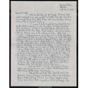
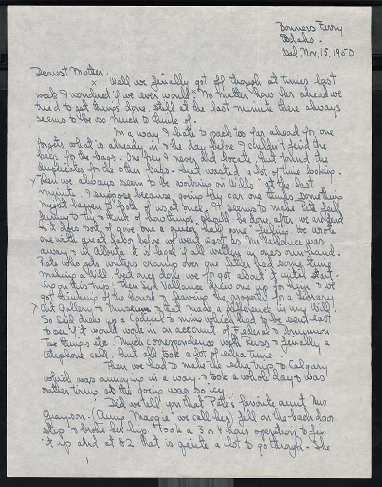
Letters to Mother [November 1950 - February 1951]
https://archives.whyte.org/en/permalink/descriptions7474
- Part Of
- Peter and Catharine Whyte fonds
- Scope & Content
- File pertains to 35 letters written by Catharine Robb Whyte to her mother, Edith Morse Robb from November 15, 1950 to February 19, 1951. Topics include driving down through Idaho, Washington and Oregon to catch a boat from Los Angeles to Hawaii, time spent in San Francisco visiting with Belmore Bro…
- Date Range
- 1950-1951
- Reference Code
- M36 / I / A / 2b / i / 128
- Description Level
- 5 / File
- GMD
- Private record
1 image
1 Electronic Resource
- Part Of
- Peter and Catharine Whyte fonds
- Description Level
- 5 / File
- Fonds Number
- M36 / V683 / S37
- Series
- I.A.2. Catharine Robb Whyte papers / photographs
- Sous-Fonds
- M36
- Accession Number
- .
- Reference Code
- M36 / I / A / 2b / i / 128
- GMD
- Private record
- Date Range
- 1950-1951
- Physical Description
- 2 cm of textual records (132 pages ; 21.4 x 27.5 cm or smaller)
- History / Biographical
- See fonds level description.
- Scope & Content
- File pertains to 35 letters written by Catharine Robb Whyte to her mother, Edith Morse Robb from November 15, 1950 to February 19, 1951. Topics include driving down through Idaho, Washington and Oregon to catch a boat from Los Angeles to Hawaii, time spent in San Francisco visiting with Belmore Browne, happenings on the ship [the SS President Wilson of American President Lines], arriving and first staying in Waikiki, moving to Waimanalo, visiting with friends, weather, Christmas cards, holiday activities, tropical food and flowers, radio programs, travelling around to different parts of Oahu, travel back to San Francisco by ship [the SS President Wilson again], driving from San Francisco to Golden, and boarding the train in Golden to Banff [the Jeep was shipped via train as well]. Also includes brochures for Hawaii hotels and a map of the island of Oahu, Hawaii.
- Notes
- Please note: language pertaining to Indigenous Peoples used throughout is outdated and may be offensive. Letters are hand-written. Some letters are written on letterhead from ships or hotels. Some letters contain small sketches of hotel/motel layouts, road layouts, and room/ship cabin details. Some letters are marked with a small x in pencil, indicating where Jon Whyte made notes for use in his project "Catharine Robb Whyte, Peter Whyte: Commemorative Portfolio," originally published in 1981. Brochures and map are not clearly attached to specific letters so are counted as their own entries. Many letters are written on very thin paper [possibly tracing paper]. 128 / 25 is mis-numbered, missed numbering page 5.
- Name Access
- Whyte, Catharine
- Whyte, Peter
- Robb, Edith Morse
- Browne, Belmore
- Whyte, Dorothy
- Castle, Donald
- Subject Access
- Activities
- Animals
- Art
- Artists
- Banff
- Beach
- Boats
- Canadian Pacific Railway
- Community events
- Community life
- Correspondence
- Cruise ships
- Family
- Family and personal life
- Flowers
- Garden
- Leisure
- Painting
- Personal and Family Life
- Photography
- Roads
- Scenery
- Trains
- Travel
- Winter
- Weather
- Geographic Access
- Banff
- Banff National Park
- Alberta
- British Columbia
- Concord
- Massachusetts
- California
- Oahu
- Hawaii
- Canada
- United States of America
- Language
- English
- Creator
- Robb Whyte, Catharine
- Title Source
- Title based on contents of file.
- Processing Status
- Processed
Electronic Resources
Images
This material is presented as originally created; it may contain outdated cultural descriptions and
potentially offensive content.
Read more.