Narrow Results By
Alberta, Canada : transportation
https://archives.whyte.org/en/permalink/catalogue24407
- Medium
- Library - Maps and blueprints (unannotated; published)
- Map
- Published Date
- 1980
- Publisher
- Edmonton : Alberta Transportation
- Call Number
- C9-1.17
- Publisher
- Edmonton : Alberta Transportation
- Published Date
- 1980
- Physical Description
- 1 map : col
- Scale
- Scale indeterminable
- Accession Number
- 3287
- Call Number
- C9-1.17
- Collection
- Archives Library
This material is presented as originally created; it may contain outdated cultural descriptions and
potentially offensive content.
Read more.
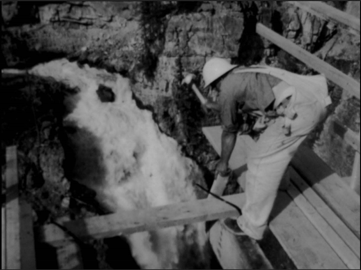
Asphalt Over the Top
https://archives.whyte.org/en/permalink/descriptions57624
- Part Of
- Bruno Engler fonds
- Scope & Content
- Item consists of one 16 mm motion picture pertaining to construction of the Icefield Parkway between Banff and Jasper. Includes scenic shots of viewpoints along the way, as well as construction of the road itself and bridges over various rivers and waterfalls up to the Columbia Icefield Discovery C…
- Date Range
- 1961
- Reference Code
- V190 / VI / NF - 44
- Description Level
- 6 / Item
- GMD
- Film
- Motion picture
1 image
- Part Of
- Bruno Engler fonds
- Description Level
- 6 / Item
- Fonds Number
- M323 / S40 / V190
- Series
- VI : Retained file
- Sous-Fonds
- V190
- Accession Number
- 7436
- Reference Code
- V190 / VI / NF - 44
- GMD
- Film
- Motion picture
- Date Range
- 1961
- Physical Description
- 1 motion picture (1 film reel: 255'): 16 mm, original, b&w, silent
- History / Biographical
- See fonds level description
- Scope & Content
- Item consists of one 16 mm motion picture pertaining to construction of the Icefield Parkway between Banff and Jasper. Includes scenic shots of viewpoints along the way, as well as construction of the road itself and bridges over various rivers and waterfalls up to the Columbia Icefield Discovery Centre. The original label on the case reads "Title Asphalt Over the Top, Camera B. Engler, Date 1961, Footage 225ft Time 7 min, For TV tape VHS."
- Subject Access
- Activities
- Advertising
- Animals
- Automobiles
- Bears
- Black Bears
- Construction
- Icefield Parkway
- Moose
- Mountains
- Rivers
- Roads
- Scenery
- scenic
- Tourism
- Waterfalls
- Geographic Access
- Banff National Park
- Alberta
- Language
- English
- Creator
- Bruno Engler
- Title Source
- Original title kept
- Processing Status
- Processed
Images
This material is presented as originally created; it may contain outdated cultural descriptions and
potentially offensive content.
Read more.
Construction, Banff-Windermere Higw
https://archives.whyte.org/en/permalink/descriptions57602
- Part Of
- Bruno Engler fonds
- Scope & Content
- Item consists of one 16 mm motion picture pertaining to construction of the Banff-Windermere Highway. Includes mostly footage of large construction machines grading and building the foundations of the highway, as well as drilling underneath the highway, presumably for drainage purposes. The origina…
- Date Range
- 1958
- Reference Code
- V190 / VI / NF - 24
- Description Level
- 6 / Item
- GMD
- Film
- Motion picture
1 image
- Part Of
- Bruno Engler fonds
- Description Level
- 6 / Item
- Fonds Number
- M323 / S40 / V190
- Series
- VI : Retained file
- Sous-Fonds
- V190
- Accession Number
- 7436
- Reference Code
- V190 / VI / NF - 24
- GMD
- Film
- Motion picture
- Date Range
- 1958
- Physical Description
- 1 motion picture (1 film reel: ca. 300'): 16 mm, original, col., silent
- History / Biographical
- See fonds level description
- Scope & Content
- Item consists of one 16 mm motion picture pertaining to construction of the Banff-Windermere Highway. Includes mostly footage of large construction machines grading and building the foundations of the highway, as well as drilling underneath the highway, presumably for drainage purposes. The original label on the case reads "Construction, Banff-Windermere Higw, Color, Date 1958, Footage 300ft, Camera: B. Engler."
- Subject Access
- Automobiles
- Construction
- Mountains
- Scenery
- scenic
- Roads
- Geographic Access
- Banff National Park
- Alberta
- Kootenay National Park
- British Columbia
- Language
- English
- Creator
- Engler, Bruno
- Title Source
- Original title kept
- Processing Status
- Processed
Images

This material is presented as originally created; it may contain outdated cultural descriptions and
potentially offensive content.
Read more.
Map of Banff and vicinity showing major highway, other roads, viewpoints, campgrounds, trailer park, picnic areas, lifts, trails
https://archives.whyte.org/en/permalink/catalogue21352
- Medium
- Library - Maps and blueprints (unannotated; published)
- Map
- Published Date
- ca. 1970
- Call Number
- C6-4.3(f)
- Published Date
- ca. 1970
- Notes
- Map B on reverse side of A shows the townsite in a larger scale
- file transfer
- Accession Number
- 5500
- Call Number
- C6-4.3(f)
- Collection
- Archives Library
This material is presented as originally created; it may contain outdated cultural descriptions and
potentially offensive content.
Read more.
Map of Banff and vicinity showing major highway, other roads, viewpoints, campgrounds, trailer park, picnic areas, lifts, trails
https://archives.whyte.org/en/permalink/catalogue21382
- Medium
- Library - Maps and blueprints (unannotated; published)
- Map
- Published Date
- ca. 1970
- Call Number
- C6-4.3(f)
- Published Date
- ca. 1970
- Notes
- Map B on reverse side of A shows the townsite in a larger scale
- file transfer
- Accession Number
- 5500
- Call Number
- C6-4.3(f)
- Collection
- Archives Library
This material is presented as originally created; it may contain outdated cultural descriptions and
potentially offensive content.
Read more.
Map showing trail outings at Banff, Spray River Valley, Tunnel Mountain area, Summit of Sulphur, Stoney Squaw Mountain, Lower Bow Valley, Sundance Canyon, Rundle Mountain
https://archives.whyte.org/en/permalink/catalogue21353
- Medium
- Library - Maps and blueprints (unannotated; published)
- Map
- Publisher
- Northern Affairs & Natural Resources
- Call Number
- C6-4.3(g)
- Publisher
- Northern Affairs & Natural Resources
- Subjects
- Banff National Park - Roads & Trails
- Notes
- Info on reverse side re: routes etc.
- Accession Number
- 2613
- Call Number
- C6-4.3(g)
- Collection
- Archives Library
This material is presented as originally created; it may contain outdated cultural descriptions and
potentially offensive content.
Read more.
Map showing trail outings at Banff, Spray River Valley, Tunnel Mountain area, Summit of Sulphur, Stoney Squaw Mountain, Lower Bow Valley, Sundance Canyon, Rundle Mountain
https://archives.whyte.org/en/permalink/catalogue21383
- Medium
- Library - Maps and blueprints (unannotated; published)
- Map
- Publisher
- Northern Affairs & Natural Resources
- Call Number
- C6-4.3(g)
- Publisher
- Northern Affairs & Natural Resources
- Subjects
- Banff National Park - Roads & Trails
- Notes
- Info on reverse side re: routes etc.
- Accession Number
- 2613
- Call Number
- C6-4.3(g)
- Collection
- Archives Library
This material is presented as originally created; it may contain outdated cultural descriptions and
potentially offensive content.
Read more.
Motor roads to the Canadian Rockies
https://archives.whyte.org/en/permalink/catalogue24316
- Medium
- Library - Maps and blueprints (unannotated; published)
- Map
- Published Date
- 1920
- Call Number
- C6-4.3(b)
- Published Date
- 1920
- Scale
- 1 inch - 18 miles
- Subjects
- Motor Roads
- Notes
- Photostatic copu from Public Archives
- Accession Number
- 675
- Call Number
- C6-4.3(b)
- Collection
- Archives Library
This material is presented as originally created; it may contain outdated cultural descriptions and
potentially offensive content.
Read more.
Motor roads to the Canadian Rockies
https://archives.whyte.org/en/permalink/catalogue23383
- Medium
- Library - Maps and blueprints (unannotated; published)
- Map
- Published Date
- 1920
- Call Number
- C6-4.3(b)
- Published Date
- 1920
- Scale
- 1 inch - 18 miles
- Subjects
- Motor Roads
- Notes
- Photostatic copu from Public Archives
- Accession Number
- 675
- Call Number
- C6-4.3(b)
- Collection
- Archives Library
This material is presented as originally created; it may contain outdated cultural descriptions and
potentially offensive content.
Read more.
Sketch map showing the vicinity of Lake Louise, Moraine Lake and Vermilion Pass
https://archives.whyte.org/en/permalink/catalogue21355
- Medium
- Library - Maps and blueprints (unannotated; published)
- Map
- Published Date
- 1905
- Publisher
- Department of the Interior
- Call Number
- C6-4.3(i)
- Publisher
- Department of the Interior
- Published Date
- 1905
- Subjects
- Lake Louise - Roads & Trails
- Notes
- Driving Roads, Pony trails
- From photographic surveys by A.O. Wheeler, Topographer of the Department assisted by M.P. Bridgland D.L.S. and H.G. Wheeler
- Accession Number
- 3120
- Call Number
- C6-4.3(i)
- Collection
- Archives Library
This material is presented as originally created; it may contain outdated cultural descriptions and
potentially offensive content.
Read more.