Narrow Results By
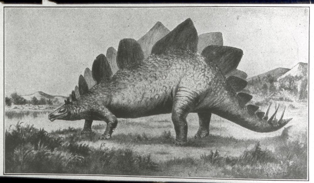
548. Historical Geography Fig. 512 Restoration of Stegosaurus (After F. A. Lucas)
https://archives.whyte.org/en/permalink/descriptions38908
- Part Of
- Mary Schaffer fonds
- Date Range
- [ca. 1908 - 192-]
- Reference Code
- V527 / PS 1 - 954
- Description Level
- 6 / Item
- GMD
- Photograph
- Lantern slide
- Transparency
1 image
- Part Of
- Mary Schaffer fonds
- Description Level
- 6 / Item
- Series
- II. Photography series
- Sub-Series
- A. Lantern slides 10. World travels
- Reference Code
- V527 / PS 1 - 954
- Date Range
- [ca. 1908 - 192-]
- Physical Description
- 1 transparency : lantern slide
- Subject Access
- Science and technology
- Education
- Geographic Access
- United States of America
Images
This material is presented as originally created; it may contain outdated cultural descriptions and
potentially offensive content.
Read more.
Aerial photographs
https://archives.whyte.org/en/permalink/descriptions56181
- Part Of
- Douglas Leighton fonds
- Scope & Content
- File consists of aerial photographs of terrain in British Columbia and Alberta. Including Banff National Park, Canmore, Kananaskis, Kootenay National Park and Jasper National Park. Images include glaciers, lakes, mountain ranges, forest, highways, and trails.
- Date Range
- 1993
- 1996
- 1997
- 1987
- Reference Code
- V222 / IV / A / 2 / NS - 1 to 134
- Description Level
- 5 / File
- GMD
- Photograph
- Transparency
- Part Of
- Douglas Leighton fonds
- Description Level
- 5 / File
- Fonds Number
- M133
- V222
- Series
- V222 / IV : Scenic Views
- Sous-Fonds
- V222
- Sub-Series
- V222 / IV / A: Aerial Photographs
- Accession Number
- 2020.24
- Reference Code
- V222 / IV / A / 2 / NS - 1 to 134
- Date Range
- 1993
- 1996
- 1997
- 1987
- Physical Description
- 134 photographs : col. slides ; 35 mm
- Scope & Content
- File consists of aerial photographs of terrain in British Columbia and Alberta. Including Banff National Park, Canmore, Kananaskis, Kootenay National Park and Jasper National Park. Images include glaciers, lakes, mountain ranges, forest, highways, and trails.
- Name Access
- Leighton, Douglas
- Subject Access
- Photo Survey
- Photography
- Mountain
- Geographic Access
- Banff National Park
- Jumbo Mountain
- Toby Creek
- Kootenay National Park
- Canmore, Alberta
- Kananaskis
- Canadian Rocky Mountains
- Jasper National Park
- Mt. Robson
- Assininboine Provincial Park
- Language
- English
- Creator
- Douglas Leighton
- Title Source
- Title based on contents of file
- Processing Status
- Processed
This material is presented as originally created; it may contain outdated cultural descriptions and
potentially offensive content.
Read more.
Aerial photographs
https://archives.whyte.org/en/permalink/descriptions56182
- Part Of
- Douglas Leighton fonds
- Scope & Content
- File consists of aerial photographs of terrain in British Columbia and Alberta. Includes photographs of Jasper National Park and Banff National Park. Images include glaciers, lakes, mountain ranges, forest, highways, and trails.
- Date Range
- 1987
- 1988
- 1993
- 1994
- Reference Code
- V222 / IV / A / 3 / NS - 1 to 125
- Description Level
- 5 / File
- GMD
- Photograph
- Transparency
- Part Of
- Douglas Leighton fonds
- Description Level
- 5 / File
- Fonds Number
- M133
- V222
- Series
- V222 / IV : Scenic Views
- Sous-Fonds
- V222
- Sub-Series
- V222 / IV / A: Aerial Photographs
- Accession Number
- 2020.24
- Reference Code
- V222 / IV / A / 3 / NS - 1 to 125
- Date Range
- 1987
- 1988
- 1993
- 1994
- Physical Description
- 125 photographs : col. slides ; 35 mm
- Scope & Content
- File consists of aerial photographs of terrain in British Columbia and Alberta. Includes photographs of Jasper National Park and Banff National Park. Images include glaciers, lakes, mountain ranges, forest, highways, and trails.
- Name Access
- Leighton, Douglas
- Subject Access
- Photo Survey
- Photography
- Mountain
- Geographic Access
- Banff National Park
- Jasper National Park
- Language
- English
- Creator
- Douglas Leighton
- Title Source
- Title based on contents of file
- Processing Status
- Processed
This material is presented as originally created; it may contain outdated cultural descriptions and
potentially offensive content.
Read more.
Aerial photographs
https://archives.whyte.org/en/permalink/descriptions56184
- Part Of
- Douglas Leighton fonds
- Scope & Content
- File consists of aerial photographs of terrain in Banff National Park, Yoho National Park, Jasper National Park. Images include glaciers, lakes, mountain ranges, forest, highways, and trails.
- Date Range
- 1987
- 1995
- 1996
- Reference Code
- V222 / IV / A / 5 / NS - 1 to 105
- Description Level
- 5 / File
- GMD
- Photograph
- Transparency
- Part Of
- Douglas Leighton fonds
- Description Level
- 5 / File
- Fonds Number
- M133
- V222
- Series
- V222 / IV : Scenic Views
- Sous-Fonds
- V222
- Sub-Series
- V222 / IV / A: Aerial Photographs
- Accession Number
- 2020.24
- Reference Code
- V222 / IV / A / 5 / NS - 1 to 105
- Date Range
- 1987
- 1995
- 1996
- Physical Description
- 105 photographs : col. slides ; 35 mm
- Scope & Content
- File consists of aerial photographs of terrain in Banff National Park, Yoho National Park, Jasper National Park. Images include glaciers, lakes, mountain ranges, forest, highways, and trails.
- Name Access
- Leighton, Douglas
- Subject Access
- Photo Survey
- Photography
- Mountain
- Geographic Access
- Banff National Park
- Jasper National Park
- Canadian Rocky Mountains
- Assiniboine Provinvial Park
- Columbia Icefields
- Yoho National Park
- Kananaskis
- Language
- English
- Creator
- Douglas Leighton
- Title Source
- Title based on contents of file
- Processing Status
- Processed
This material is presented as originally created; it may contain outdated cultural descriptions and
potentially offensive content.
Read more.
Charlie Russell fonds
https://archives.whyte.org/en/permalink/descriptions643
- Part Of
- Charlie Russell fonds
- Scope & Content
- The Charlie Russell fonds consists of photographs pertaining to the filming of "Grizzly Country", ranching, friends and family, wildlife, and recreational activities, ca.1961-ca.1968. The majority of the images were made in the Waterton Lakes area. There are some images made in New York City, Briti…
- Date Range
- ca.1961-ca.1968
- Reference Code
- V557
- Description Level
- 1 / Fonds
- GMD
- Photograph
- Negative
- Transparency
- Part Of
- Charlie Russell fonds
- Description Level
- 1 / Fonds
- Fonds Number
- V 557
- Sous-Fonds
- V557
- Accession Number
- 7728
- Reference Code
- V557
- Date Range
- ca.1961-ca.1968
- Physical Description
- ca. 2520 photographs : b&w negatives ; 35 mm and 4x5, 2 transparencies; col.
- History / Biographical
- Andrew Charles "Charlie" Russell (August 19, 1941 – May 7, 2018) was a naturalist, photographer, pilot, wilderness guide, and rancher. One of the son's of Andy Russell and Kay Russell and grandson of Bert Riggall, Charlie grew up at the Hawk's Nest ranch on the N.E. boundary of Waterton Lake National Park.
- Alongside his brother Dick Russell, Charlie assisted his father Andy in the production and filming of Grizzly Country throughout the Canadian Rockies, British Columbia, and Alaska from 1961-1964. In 1967 he returned to the Tolkat River in Alaska to photograph and observe bears alone. In 1970 he purchased a large percentage of his fathers land on Waterton's north-east border to run a cattle operation. In 1991, he made his first visit to Princess Royal Island, British Columbia, and began photographing for "Spirit Bear", a book of photographs and writings published in 1994. Beginning in 1997, Charlie spent 6 years among the grizzlies of Kamchatka Peninsula in eastern Russia alongside artist and partner Maureen Enns. After returning to Alberta from Russia, Charlie continued to be a conservation advocate until he passed from a surgery-related complication in May 2018.
- The bulk of Charlie Russell's work was destroyed in a house fire in [1991?].
- Scope & Content
- The Charlie Russell fonds consists of photographs pertaining to the filming of "Grizzly Country", ranching, friends and family, wildlife, and recreational activities, ca.1961-ca.1968. The majority of the images were made in the Waterton Lakes area. There are some images made in New York City, British Columbia, and Alaska. The fonds is comprised of two series: I. Black and white negatives; II. Transparencies; I. Black and white negatives consists of A. 1964, B. Waterton Park Flood, June 8-9, 1963, C. 35mm Books, D. 4x5 Book, E. Bert Riggall Copy Negatives. II. Transparencies consist of two 4x5 colour transparencies depicting Cal Wellman's Cattle.
- Notes
- I.C. was received in the form of three separate negative books. The books have been arranged numerically in subseries I.C, with the negative book book and page number of origin written on the negative sleeves. For example, V557/I/C/NA-1a to NA-6e [Book 1, pg. 1,2].
- Select 35mm negatives in I.C. are marked with red stickers and overlaid with rectangles on the negative sleeve. These negatives correspond to the negatives used in "Spirit Bear" and their cropping for publication. Each image is listed and described in the case file on the document titled "These are the negs used in Spirit Bear Chapter One". Some of the dots have a number corresponding to the document, others do not (the stickers were taken from the original negative sleeves and re-applied to the new negative sleeves).
- Subject Access
- Environment
- Sports, recreation and leisure
- Science and technology
- Natural resources
- Education
- Hawk's Nest Ranch
- Bears
- Wildlife
- Geographic Access
- Waterton Lakes National Park
- Mount McKinley
- Canada
- Alberta
- Alaska
- British Columbia
- United States of America
- Language
- English
- Finding Aid
- Revised digital and original handwritten in case file
- Related Material
- Related by provenance to a portion of Andy Russell fonds.
- Creator
- Russell, Charlie
- Category
- Education
- Environment
- Sports, recreation and leisure
- Science and technology
- Natural resources
- Biographical Source Notes
- Accession record.
- Handwritten documents in case file.
- "Spirit Bear, Encounters with the White Bear of the Western Rainforest", Charlie Russell, 1994, Key Porter Books Limited. Pg 12-25.
- https://charlierussellbears.com/
- Title Source
- Title based on contents of fonds
- Processing Status
- Processed
This material is presented as originally created; it may contain outdated cultural descriptions and
potentially offensive content.
Read more.
Coal Measures forest
https://archives.whyte.org/en/permalink/descriptions38910
- Part Of
- Mary Schaffer fonds
- Date Range
- [ca. 1908 - 192-]
- Reference Code
- V527 / PS 1 - 956
- Description Level
- 6 / Item
- GMD
- Photograph
- Lantern slide
- Transparency
1 image
- Part Of
- Mary Schaffer fonds
- Description Level
- 6 / Item
- Series
- II. Photography series
- Sub-Series
- A. Lantern slides 10. World travels
- Reference Code
- V527 / PS 1 - 956
- Date Range
- [ca. 1908 - 192-]
- Physical Description
- 1 transparency : lantern slide
- Subject Access
- Science and technology
- Education
- Geographic Access
- United States of America
Images

This material is presented as originally created; it may contain outdated cultural descriptions and
potentially offensive content.
Read more.
Eric Mountjoy exhibit images
https://archives.whyte.org/en/permalink/descriptions55884
- Part Of
- Ben Gadd fonds
- Scope & Content
- File consists of two discs containing digital image files which were used in the creation of an exhibit about Dr. Eric Mountjoy at the Jasper-Yellowhead Museum and Archives. File also includes printed paper copies of 10 images which are included on the two discs. Images pertain to Eric Mountjoy and…
- Date Range
- 1958-1959
- 2009
- Reference Code
- V810 / III / D / DF - 1 to 2
- Description Level
- 5 / File
- GMD
- Photograph
- Digital image
- Part Of
- Ben Gadd fonds
- Description Level
- 5 / File
- Fonds Number
- M590
- V810
- S61
- Series
- V810 / III : Professional records
- Sous-Fonds
- V810
- Sub-Series
- V810 / III / D : Other contracts and projects
- Accession Number
- 2021.20
- Reference Code
- V810 / III / D / DF - 1 to 2
- Responsibility
- Photographs produced by Roger Macqueen
- Date Range
- 1958-1959
- 2009
- Physical Description
- Two discs (80 image files) -- 10 paper reference copies of images
- Scope & Content
- File consists of two discs containing digital image files which were used in the creation of an exhibit about Dr. Eric Mountjoy at the Jasper-Yellowhead Museum and Archives. File also includes printed paper copies of 10 images which are included on the two discs. Images pertain to Eric Mountjoy and fellow geologists assessing and working in areas near Miette, Alberta.
- Notes
- Discs are labelled on front: V810 / III / D / DF - 1 : "Roger Macqueen's slides Miette mapsheet geo party 1958" [contains 60 image files] NOTE: DF - 1 is accompanied by typed summary list of images in file V810 / III / D / DF - 2 : "Roger Macqueen's slides Miette mapsheet (1st 7 images), rest are Shell Canada 1959" [contains 20 image files]
- Name Access
- Mountjoy, Eric
- Subject Access
- Research
- Science and technology
- Geology
- Environment
- Education
- Museums
- Geographic Access
- Canada
- Alberta
- Jasper National Park
- Miette
- Reproduction Restrictions
- Restrictions may apply
- Language
- English
- Related Material
- Corresponding textual records processed as file M590 / III / D / 4
- Category
- Environment
- Education
- Title Source
- Title based on contents of file
- Processing Status
- Processed
This material is presented as originally created; it may contain outdated cultural descriptions and
potentially offensive content.
Read more.
HCR info files - stratigraphy, fossils
https://archives.whyte.org/en/permalink/descriptions55956
- Part Of
- Ben Gadd fonds
- Scope & Content
- File consists of published research material collected by Ben Gadd pertaining to stratigraphy and fossils. File includes one print photograph depicting a fossil found near Mt. Stephen, British Columbia [in folder M590/II/A/27] and one print depicting a geological feature in Jasper National Park.
- Date Range
- [1980-2012]
- Reference Code
- M590 / II / A / 27 to 31
- Description Level
- 5 / File
- GMD
- Textual record
- Published record
- Photograph
- Part Of
- Ben Gadd fonds
- Description Level
- 5 / File
- Fonds Number
- M590
- V810
- S61
- Series
- M590 / II : Research and publication records
- Sous-Fonds
- M590
- Sub-Series
- M590 / II / A : Handbook of the Canadian Rockies
- Accession Number
- 2021.20
- Reference Code
- M590 / II / A / 27 to 31
- Responsibility
- Photographs produced by Christian W. Gronau of Whaletown, B.C. and Ron Kratochvil
- Date Range
- [1980-2012]
- Physical Description
- 10 cm of textual records -- 2 photographs : col. prints ; 10 x 15 cm
- Scope & Content
- File consists of published research material collected by Ben Gadd pertaining to stratigraphy and fossils. File includes one print photograph depicting a fossil found near Mt. Stephen, British Columbia [in folder M590/II/A/27] and one print depicting a geological feature in Jasper National Park.
- Notes
- Some items in file are annotated by Ben Gadd
- Material Details
- Photographs stored in file with textual records to maintain original order
- Name Access
- Gadd, Ben
- Subject Access
- Publication
- Research
- Natural history
- Environment
- Science and technology
- Geographic Access
- Canada
- Alberta
- British Columbia
- Jasper National Park
- Reproduction Restrictions
- Copyright restrictions may apply
- Language
- English
- Conservation
- Photographs stored in mylar
- Category
- Environment
- Title Source
- Title based on contents of file
- Processing Status
- Processed
This material is presented as originally created; it may contain outdated cultural descriptions and
potentially offensive content.
Read more.
Illustrations - geo
https://archives.whyte.org/en/permalink/descriptions55991
- Part Of
- Ben Gadd fonds
- Scope & Content
- File consists of photographs taken or collected by Ben Gadd pertaining to rock formations and other geological features near Meadow Creek and Miette in Jasper National Park. File also includes four photographs from Jim Aitken and the Geological Survey of Canada (Calgary, Ottawa).
- Date Range
- [ca.1990-1995]
- Reference Code
- V810 / II / A / PA - 139 to 162
- Description Level
- 5 / File
- GMD
- Photograph
- Textual record
- Part Of
- Ben Gadd fonds
- Description Level
- 5 / File
- Fonds Number
- M590
- V810
- S61
- Series
- V810 / II : Research and publication records
- Sous-Fonds
- V810
- Sub-Series
- V810 / II / A : Handbook of the Canadian Rockies
- Accession Number
- 2021.20
- Reference Code
- V810 / II / A / PA - 139 to 162
- Responsibility
- Produced by Ben Gadd, Jim Aitken, Geological Survey of Canada
- Date Range
- [ca.1990-1995]
- Physical Description
- 24 photographs : b&w and col. prints ; 20 x 15 cm or smaller
- Scope & Content
- File consists of photographs taken or collected by Ben Gadd pertaining to rock formations and other geological features near Meadow Creek and Miette in Jasper National Park. File also includes four photographs from Jim Aitken and the Geological Survey of Canada (Calgary, Ottawa).
- Notes
- Most photographs are annotated on back by Ben Gadd. Photos V810/II/A/PA-10 and 162 accompanied in file by corresponding notes/textual records
- Material Details
- Original storage envelopes (annotated) stored in folder with prints
- Name Access
- Gadd, Ben
- Subject Access
- Research
- Environment
- Geology
- Geological formation
- Geography
- Surveying
- Surveys
- Government
- Science and technology
- Geographic Access
- Canada
- Alberta
- Jasper National Park
- Miette
- Calgary
- Ontario
- Ottawa
- Reproduction Restrictions
- Restrictions may apply
- Language
- English
- Related Material
- Corresponding negative film [for V810/II/A/PA-139 to 158]: V810 / II / A / NA - 16 to 23
- Category
- Environment
- Science and technology
- Government
- Title Source
- Original title used
- Processing Status
- Processed
This material is presented as originally created; it may contain outdated cultural descriptions and
potentially offensive content.
Read more.
Illustrations - geo
https://archives.whyte.org/en/permalink/descriptions55992
- Part Of
- Ben Gadd fonds
- Scope & Content
- File consists of photographs taken or collected by Ben Gadd pertaining to rock formations and other geological features near Meadow Creek and Miette in Jasper National Park.
- Date Range
- [ca.1990-1995]
- Reference Code
- V810 / II / A / NA - 16 to 23
- Description Level
- 5 / File
- GMD
- Photograph
- Negative
- Part Of
- Ben Gadd fonds
- Description Level
- 5 / File
- Fonds Number
- M590
- V810
- S61
- Series
- V810 / II : Research and publication records
- Sous-Fonds
- V810
- Sub-Series
- V810 / II / A : Handbook of the Canadian Rockies
- Accession Number
- 2021.20
- Reference Code
- V810 / II / A / NA - 16 to 23
- GMD
- Photograph
- Negative
- Responsibility
- Produced by Ben Gadd
- Date Range
- [ca.1990-1995]
- Physical Description
- 28 photographs : col. negatives ; 35 mm
- Scope & Content
- File consists of photographs taken or collected by Ben Gadd pertaining to rock formations and other geological features near Meadow Creek and Miette in Jasper National Park.
- Material Details
- Original storage envelope (annotated) stored in folder with prints V810 / II / A / PA - 139 to 162
- Name Access
- Gadd, Ben
- Subject Access
- Research
- Environment
- Geology
- Geological formation
- Geography
- Science and technology
- Geographic Access
- Canada
- Alberta
- Jasper National Park
- Miette
- Reproduction Restrictions
- Restrictions may apply
- Language
- English
- Related Material
- Corresponding prints : V810 / II / A / PA - 139 to 158
- Category
- Environment
- Science and technology
- Title Source
- Original title used
- Processing Status
- Processed
This material is presented as originally created; it may contain outdated cultural descriptions and
potentially offensive content.
Read more.