Narrow Results By
- George Noble fonds 515
- Byron Harmon fonds 337
- Crosby family fonds 90
- Luxton family fonds 73
- Peter and Catharine Whyte fonds
- Malcolm Geddes fonds 28
- Alpine Club of Canada fonds 27
- Kidney family fonds 17
- Bert Riggall fonds 10
- Archives General File Collection 9
- Arthur Oliver Wheeler fonds 6
- Charles Reid fonds 6
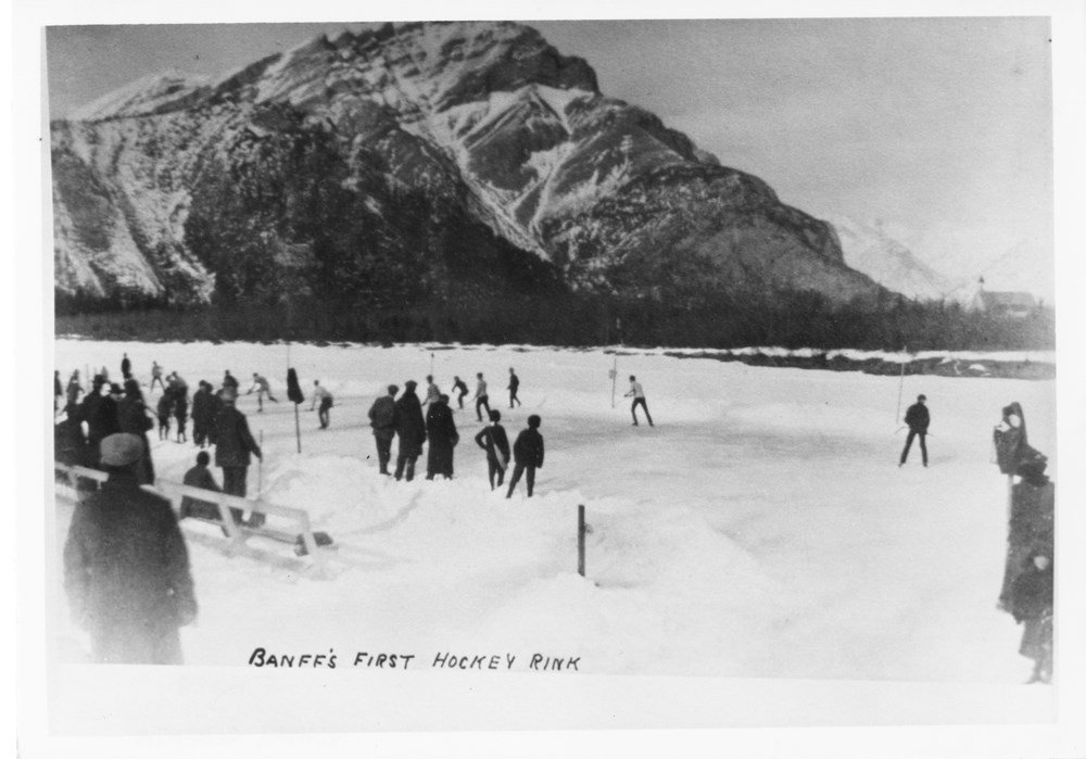
Banff's first hockey rink
https://archives.whyte.org/en/permalink/descriptions53139
- Part Of
- Peter and Catharine Whyte fonds
- Scope & Content
- Image of Banff's first hockey rink - possibly on the Bow River or modern-day recreation grounds - with a church and Cascade Mountain visible in the distance
- Date Range
- [ca. 1885-1945]
- Reference Code
- V683 / III / A / 15 / PA - 704
- Description Level
- 6 / Item
- GMD
- Photograph
2 images
- Part Of
- Peter and Catharine Whyte fonds
- Description Level
- 6 / Item
- Fonds Number
- M36 / V683 / S37
- Series
- V683 / III / A / 15 : Peter and Catharine Whyte: Collected Photographs
- Sous-Fonds
- V683
- Accession Number
- .
- Reference Code
- V683 / III / A / 15 / PA - 704
- GMD
- Photograph
- Date Range
- [ca. 1885-1945]
- Physical Description
- Photograph: 1 print (front and back) ; b&w.
- Scope & Content
- Image of Banff's first hockey rink - possibly on the Bow River or modern-day recreation grounds - with a church and Cascade Mountain visible in the distance
- Subject Access
- Bow River
- Cascade Mountain
- Hockey
- Hockey rink
- Winter
- Winter sports
- Geographic Access
- Banff National Park
- Language
- English
- Title Source
- Title based on item
- Processing Status
- Processed
Images
This material is presented as originally created; it may contain outdated cultural descriptions and
potentially offensive content.
Read more.
Cartographic Materials
https://archives.whyte.org/en/permalink/descriptions23065
- Part Of
- Hans Gmoser fonds
- Scope & Content
- Cartographic materials in these four oversized files consist of the following:
- Date Range
- 1914-1973
- Reference Code
- M224 / O.S. Cartographic
- Description Level
- 5 / File
- Part Of
- Hans Gmoser fonds
- Description Level
- 5 / File
- Series
- IV.C. Textual records: Cartographic records
- Accession Number
- 7361, 7877, 8111
- Reference Code
- M224 / O.S. Cartographic
- Date Range
- 1914-1973
- Physical Description
- 48 cartographic records.
- Scope & Content
- Cartographic materials in these four oversized files consist of the following:
- Subject Access
- Discovery and Exploration
- Environment and Nature
- Family and personal life
- Sports and Recreation
- Title Source
- Title based on contents.
- Content Details
- Folder 1 Map on heavy paper, wrapped in plastic. “A Reconnaissance Topographic Map Suveyed and edited by Bradford Washburn” printed in Bern, Switzerland. Centred on Mt. McKinley.- From 7361. Palliser- Kananaskis Area British Columbia and Alberta- Publication No. 1962- Reprinted by the Surveys and Mapping Branch, Department of Mines and Technical Surveys, Ottawa. Mistaya British Columbia and Alberta- Compiled, drawn and printed at the office of the Surveyor General, Ottawa, 1931. Reprinted with corrections at the Surveys and Mapping Branch, Ottawa, 1950. National Topographic Series. Yoho British Columbia and Alberta- Compiled, drawn and printed at the office of the Surveyor General, Ottawa, 1932. Reprinted with corrections at the Surveys and Mapping Branch, Ottawa, 1952. National Topographic Series. Price 25 cents. Invermere British Columbia Kootenay Land District- National Topographic System- First Status Edition compiled and produced by the Geographic Division, Surveys, and Mapping Branch, Dept. of Lands, Forests and Water Resources, Victoria, BC 1964-65- annotated Beaton British Columbia Kootenay Land District- National Topographic System- First Status Edition compiled and produced by the Geographic Division, Surveys, and Mapping Branch, Dept. of Lands, Forests and Water Resources, Victoria, BC 1964-66- annotated Lardeau British Columbia Kootenay Land District- National Topographic System- First Status Edition compiled and produced by the Geographic Division, Surveys, and Mapping Branch, Dept. of Lands, Forests and Water Resources, Victoria, BC 1963- annotated Mount McKinley Alaska, Published by the Museum of Science, Boston, Mass, USA and the Swiss Foundation for Alpine Research, Zurich. 1960. Centennial Range Yukon Territory- M.C.R. 7 Edition 1- Produced and printed 1967 by the Surveys and Mapping Branch, Department of Energy, Mines and Resources- maps printed in 1961-62- annotated British Columbia Land Recording Dists.- Land Commissioner’s Offices- Department of Lands and Forests- first published 1957- Updated Nov. 1, 1960. Master Site Plan Bugaboo Creek Lodge Project number 6844- June 18, 1973- Cohos Delesalle & Evamy. Folder 2 Boundary Between Alberta and BC- Athabasca Pass- Sheet No. 27A – annotated- centered on Jasper Park Boundary Between Alberta and BC-All below Wheeler Maps (by hand) used for the Great Divide as per Chic-no topographical maps used for both Hans and similar maps were used by Chic bottom rip taped- Sheet No. 20- Drawn and printed by the Topographical Survey of Canada, Ottawa - centered on Clearwater forest and Lyell Icefield at bottom right Boundary Between Alberta and BC- Sheet No. 15- Drawn and printed at the Surveyor General’s Office, Ottawa, Canada- centered on Rocky Mountains Park Boundary Between Alberta and BC - Sheet No. 19- Drawn and printed at the Surveyor General’s Office, Ottawa, Canada- centered on centered on Clearwater Forest with Mt. Alan Campbell at bottom Boundary Between Alberta and BC- Sheet No. 25- annotated- Drawn and printed by the Topographical Survey of Canada, Ottawa - centered on Jasper Park with Chisel Peak at bottom Boundary Between Alberta and BC- Sheet No. 19- dirt and annotated- revised 1925- drawn and printed by the Topographical Survey of Canada, Ottawa- centered on Clearwater and Push Pass W. Boundary Between Alberta and BC- annotated- Sheet 16- revised 1925- drawn and printed by the Topographical Survey of Canada, Ottawa- centered on Yoho Park and Rocky Mountains Park Steele Glacier- Topographical Survey 1967 Arial Photography 1951 Mount St. Elias Canada- United State of America- Produced and Printed by the Surveys and Mapping Branch, Department of Mines and Technical Surveys 1962 from air photographs taken in 1951 and 1956- annotated Woolsey Glacier- Revelstoke National Park British Columbia – Printed by the Surveys and Mapping Branch Department of Energy, Mines and Resources- 1967 Windermere Kootenay District- Map 165A Issued 1918- Reprinted by the Surveys and Mapping Branch, Department of Mines and Technical Surveys, Ottawa. Folder 3 Boundary Between Alberta and BC- Sheet No. 20- heavily annotated- revised 1925- drawn and printed by the Topographical Survey of Canada, Ottawa- centered on Clearwater Forest, Saskatchewan Glacier at top left Boundary Between Alberta and BC- Sheet No. 18- heavily ripped- annotated - notes on back- revised 1925- drawn and printed by the Topographical Survey of Canada, Ottawa- centered on Clearwater Forest, Mt Mummery at bottom Boundary Between Alberta and BC- Sheet No. 17 (in pencil “A and B”)- annotated - heavily ripped- drawn and printed at the Surveyor Generals’ Office- centered on Clearwater Forest and Yoho Park Boundary Between Alberta and BC- Sheet No. 26- annotated- revised 1925- drawn and printed by the Topographical Survey of Canada, Ottawa- centered on Jasper Park and Icefields Boundary Between Alberta and BC- Sheet No. 17- revised 1925- drawn and printed by the Topographical Survey of Canada, Ottawa- centered on Clearwater Forest and Yoho Park Boundary Between Alberta and BC- Sheet No. 28- stained- centered on Jasper Park Boundary Between Alberta and BC- Sheet No. 24- annotated- revised edition, 1925- drawn and printed by the Topographical Survey of Canada, Ottawa- centered on Jasper Park Boundary Between Alberta and BC- Sheet No. 16- annotated- revised 1925- drawn and printed by the Topographical Survey of Canada, Ottawa- centered on Yoho and Rocky Mountains Park Interprovincial Boundary Commission Boundary Between Alberta and British Columbia. Revised edition 1925 drawn and printed by the Topographical Survey of Canada, Ottawa. Sheet No. 27. Following maps are from accession 7877. Interprovincial Boundary Commission Boundary Between Alberta and British Columbia. Surveyed 1920. Drawn and printed by the Topographical Survey of Canada, Ottawa. Sheet No. 26. Interprovincial Boundary Commission Boundary Between Alberta and British Columbia. Surveyed 1920, 1921. Drawn and printed by the Topographical Survey of Canada, Ottawa. Sheet No. 25. Interprovincial Boundary Commission Boundary Between Alberta and British Columbia. Surveyed 1919, 1921. Drawn and printed by the Topographical Survey of Canada, Ottawa. Sheet No. 24. Interprovincial Boundary Commission Boundary Between Alberta and British Columbia. Revised edition 1925 drawn and printed by the Topographical Survey of Canada, Ottawa. Sheet No. 21. Interprovincial Boundary Commission Boundary Between Alberta and British Columbia. Revised edition 1925 drawn and printed by the Topographical Survey of Canada, Ottawa. Sheet No. 18. Interprovincial Boundary Commission Boundary Between Alberta and British Columbia. Surveyed 1913. Drawn and printed by the Topographical Survey of Canada, Ottawa. Sheet No. 13 A. Interprovincial Boundary Commission Boundary Between Alberta and British Columbia. Surveyed 1916. Drawn and printed by the Topographical Survey of Canada, Ottawa. Sheet No. 12 A. Interprovincial Boundary Commission Boundary Between Alberta and British Columbia. Surveyed 1916. Drawn and printed by the Topographical Survey of Canada, Ottawa. Sheet No. 11. Interprovincial Boundary Commission Boundary Between Alberta and British Columbia. Surveyed 1916. Drawn and printed by the Topographical Survey of Canada, Ottawa. Sheet No. 10. Interprovincial Boundary Commission Boundary Between Alberta and British Columbia. Surveyed 1916. Drawn and printed by the Topographical Survey of Canada, Ottawa. Sheet No. 9. Interprovincial Boundary Commission Boundary Between Alberta and British Columbia. Surveyed 1916. Drawn and printed by the Topographical Survey of Canada, Ottawa. Sheet No. 8. Interprovincial Boundary Commission Boundary Between Alberta and British Columbia. Surveyed 1916. Drawn and printed by the Topographical Survey of Canada, Ottawa. Sheet No. 6. Interprovincial Boundary Commission Boundary Between Alberta and British Columbia. Surveyed 1915. Drawn and printed by the Topographical Survey of Canada, Ottawa. Sheet No. 5. Interprovincial Boundary Commission Boundary Between Alberta and British Columbia. Surveyed 1914. Drawn and printed by the Topographical Survey of Canada, Ottawa. Sheet No. 4. Interprovincial Boundary Commission Boundary Between Alberta and British Columbia. Surveyed 1922. Drawn and printed by the Topographical Survey of Canada, Ottawa. Sheet No. 31. Interprovincial Boundary Commission Boundary Between Alberta and British Columbia. Surveyed 1922, 1924. Drawn and printed by the Topographical Survey of Canada, Ottawa. Sheet No. 30. Interprovincial Boundary Commission Boundary Between Alberta and British Columbia. Surveyed 1917. Drawn and printed by the Topographical Survey of Canada, Ottawa. Sheet No. 29.
- Processing Status
- Processed
This material is presented as originally created; it may contain outdated cultural descriptions and
potentially offensive content.
Read more.
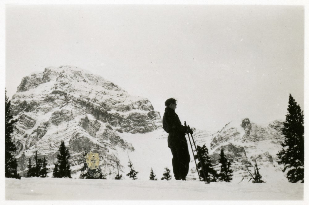
Catharine Whyte on skis
https://archives.whyte.org/en/permalink/descriptions51502
- Part Of
- Peter and Catharine Whyte fonds
- Scope & Content
- Image of Catharine Whye on skis with an unidentified mountain in the distance - taken from below
- Date Range
- [ca. 1920-1940]
- Reference Code
- V683 / III / A / 5 / PA - 127
- Description Level
- 6 / Image
- GMD
- Photograph
1 image
- Part Of
- Peter and Catharine Whyte fonds
- Description Level
- 6 / Image
- Fonds Number
- M36 / V683 / S37
- Series
- V683 / III / A / 5 : Peter and Catharine Whyte: Landscapes
- Sous-Fonds
- V683
- Accession Number
- .
- Reference Code
- V683 / III / A / 5 / PA - 127
- GMD
- Photograph
- Date Range
- [ca. 1920-1940]
- Physical Description
- Photograph: 1 print ; b&w.
- Scope & Content
- Image of Catharine Whye on skis with an unidentified mountain in the distance - taken from below
- Name Access
- Whyte, Catharine
- Language
- English
- Title Source
- Title based on item
- Processing Status
- Processed
Images
This material is presented as originally created; it may contain outdated cultural descriptions and
potentially offensive content.
Read more.
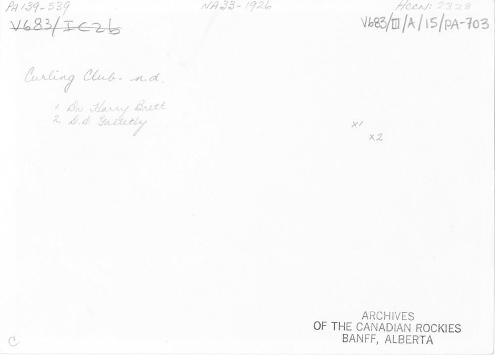
- Part Of
- Peter and Catharine Whyte fonds
- Scope & Content
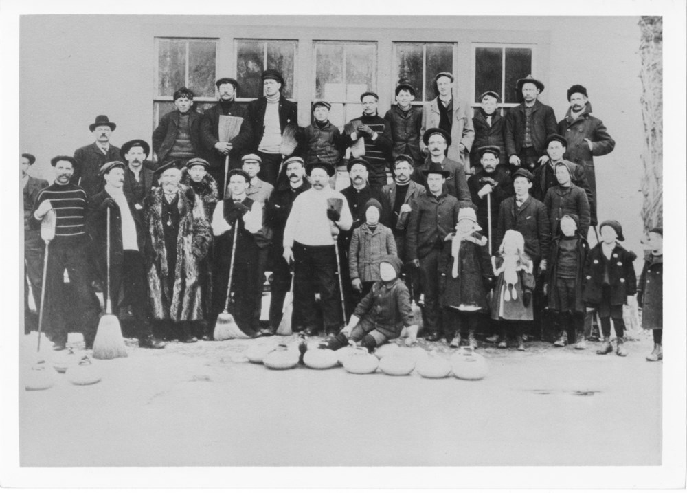
- Image of the Banff Curling Club posed in front of a building - Dr. Harry Brett and D.D. Galletly identified by annotation on the back
- Date Range
- [ca. 1885-1945]
- Reference Code
- V683 / III / A / 15 / PA - 703
- Description Level
- 6 / Item
- GMD
- Photograph
2 images
- Part Of
- Peter and Catharine Whyte fonds
- Description Level
- 6 / Item
- Fonds Number
- M36 / V683 / S37
- Series
- V683 / III / A / 15 : Peter and Catharine Whyte: Collected Photographs
- Sous-Fonds
- V683
- Accession Number
- .
- Reference Code
- V683 / III / A / 15 / PA - 703
- GMD
- Photograph
- Date Range
- [ca. 1885-1945]
- Physical Description
- Photograph: 1 print (front and back) ; b&w.
- Scope & Content
- Image of the Banff Curling Club posed in front of a building - Dr. Harry Brett and D.D. Galletly identified by annotation on the back
- Subject Access
- Banff Curling Club
- Curling
- Community life
- Winter sports
- Geographic Access
- Banff National Park
- Language
- English
- Title Source
- Title based on item
- Processing Status
- Processed
Images
This material is presented as originally created; it may contain outdated cultural descriptions and
potentially offensive content.
Read more.
Group of boxers
https://archives.whyte.org/en/permalink/descriptions53182
- Part Of
- Peter and Catharine Whyte fonds
- Scope & Content
- Image of a group of unidentified men dressed for a boxing match
- Date Range
- [ca. 1910-1925]
- Reference Code
- V683 / III / A / 15 / PA - 745
- Description Level
- 6 / Item
- GMD
- Photograph
1 image
- Part Of
- Peter and Catharine Whyte fonds
- Description Level
- 6 / Item
- Fonds Number
- M36 / V683 / S37
- Series
- V683 / III / A / 15 : Peter and Catharine Whyte: Collected Photographs
- Sous-Fonds
- V683
- Accession Number
- .
- Reference Code
- V683 / III / A / 15 / PA - 745
- GMD
- Photograph
- Date Range
- [ca. 1910-1925]
- Physical Description
- Photograph: 1 print ; b&w.
- Scope & Content
- Image of a group of unidentified men dressed for a boxing match
- Language
- English
- Title Source
- Title based on item
- Processing Status
- Processed
Images

This material is presented as originally created; it may contain outdated cultural descriptions and
potentially offensive content.
Read more.
Group of skiers
https://archives.whyte.org/en/permalink/descriptions52867
- Part Of
- Peter and Catharine Whyte fonds
- Scope & Content
- Image of four unidentified skiers standing in a line looking over a snowy landscape - "On the Silvertip Ski Run - Mount Temple Lodge" written on the back in pencil
- Date Range
- [ca. 1929-1935]
- Reference Code
- V683 / III / A / 15 / PA - 56
- Description Level
- 6 / Item
- GMD
- Photograph
2 images
- Part Of
- Peter and Catharine Whyte fonds
- Description Level
- 6 / Item
- Fonds Number
- M36 / V683 / S37
- Series
- V683 / III / A / 15 : Peter and Catharine Whyte: Collected Photographs
- Sous-Fonds
- V683
- Accession Number
- .
- Reference Code
- V683 / III / A / 15 / PA - 56
- GMD
- Photograph
- Date Range
- [ca. 1929-1935]
- Physical Description
- Photograph: 1 print (front and back) ; b&w.
- Scope & Content
- Image of four unidentified skiers standing in a line looking over a snowy landscape - "On the Silvertip Ski Run - Mount Temple Lodge" written on the back in pencil
- Subject Access
- Mountains
- Skiing
- Ski areas
- Winter
- Winter sports
- Geographic Access
- Banff National Park
- Language
- English
- Title Source
- Title based on item
- Processing Status
- Processed
Images


This material is presented as originally created; it may contain outdated cultural descriptions and
potentially offensive content.
Read more.
Group of skiers
https://archives.whyte.org/en/permalink/descriptions52868
- Part Of
- Peter and Catharine Whyte fonds
- Scope & Content
- Image of four skiers walking through a snowy landscape - taken from above and at a distance - "Ascending the Silvertip Ski Run - Mount Temple Lodge" written on the back in pencil
- Date Range
- [ca. 1929-1935]
- Reference Code
- V683 / III / A / 15 / PA - 57
- Description Level
- 6 / Item
- GMD
- Photograph
2 images
- Part Of
- Peter and Catharine Whyte fonds
- Description Level
- 6 / Item
- Fonds Number
- M36 / V683 / S37
- Series
- V683 / III / A / 15 : Peter and Catharine Whyte: Collected Photographs
- Sous-Fonds
- V683
- Accession Number
- .
- Reference Code
- V683 / III / A / 15 / PA - 57
- GMD
- Photograph
- Date Range
- [ca. 1929-1935]
- Physical Description
- Photograph: 1 print (front and back) ; b&w.
- Scope & Content
- Image of four skiers walking through a snowy landscape - taken from above and at a distance - "Ascending the Silvertip Ski Run - Mount Temple Lodge" written on the back in pencil
- Subject Access
- Mountains
- Skiing
- Ski areas
- Winter
- Winter sports
- Geographic Access
- Banff National Park
- Language
- English
- Title Source
- Title based on item
- Processing Status
- Processed
Images


This material is presented as originally created; it may contain outdated cultural descriptions and
potentially offensive content.
Read more.
Group of skiers
https://archives.whyte.org/en/permalink/descriptions52874
- Part Of
- Peter and Catharine Whyte fonds
- Scope & Content
- Image of a group of skiers crouched going down a snowy slope with mountains in the distance - taken from above - "Skoki" written on the back in pencil by Catharine Whyte
- Date Range
- [ca. 1929-1940]
- Reference Code
- V683 / III / A / 15 / PA - 63
- Description Level
- 6 / Item
- GMD
- Photograph
2 images
- Part Of
- Peter and Catharine Whyte fonds
- Description Level
- 6 / Item
- Fonds Number
- M36 / V683 / S37
- Series
- V683 / III / A / 15 : Peter and Catharine Whyte: Collected Photographs
- Sous-Fonds
- V683
- Accession Number
- .
- Reference Code
- V683 / III / A / 15 / PA - 63
- GMD
- Photograph
- Date Range
- [ca. 1929-1940]
- Physical Description
- Photograph: 1 print (front and back) ; b&w.
- Scope & Content
- Image of a group of skiers crouched going down a snowy slope with mountains in the distance - taken from above - "Skoki" written on the back in pencil by Catharine Whyte
- Subject Access
- Mountains
- Skiing
- Ski areas
- Winter
- Winter sports
- Geographic Access
- Banff National Park
- Language
- English
- Title Source
- Title based on item
- Processing Status
- Processed
Images


This material is presented as originally created; it may contain outdated cultural descriptions and
potentially offensive content.
Read more.
Group of skiers
https://archives.whyte.org/en/permalink/descriptions53075
- Part Of
- Peter and Catharine Whyte fonds
- Scope & Content
- Image of four unidentified skiers standing in a basin at the bottom of a mountain - possibly in the Skoki area
- Date Range
- [ca. 1920-1945]
- Reference Code
- V683 / III / A / 15 / PA - 639
- Description Level
- 6 / Item
- GMD
- Photograph
1 image
- Part Of
- Peter and Catharine Whyte fonds
- Description Level
- 6 / Item
- Fonds Number
- M36 / V683 / S37
- Series
- V683 / III / A / 15 : Peter and Catharine Whyte: Collected Photographs
- Sous-Fonds
- V683
- Accession Number
- .
- Reference Code
- V683 / III / A / 15 / PA - 639
- GMD
- Photograph
- Date Range
- [ca. 1920-1945]
- Physical Description
- Photograph: 1 print ; b&w.
- Scope & Content
- Image of four unidentified skiers standing in a basin at the bottom of a mountain - possibly in the Skoki area
- Subject Access
- Mountains
- Skiing
- Winter
- Winter sports
- Language
- English
- Title Source
- Title based on item
- Processing Status
- Processed
Images

This material is presented as originally created; it may contain outdated cultural descriptions and
potentially offensive content.
Read more.
Group of skiers
https://archives.whyte.org/en/permalink/descriptions53077
- Part Of
- Peter and Catharine Whyte fonds
- Scope & Content
- Image of a group of skiers crouched down over their skis going down a hill
- Date Range
- [ca. 1920-1945]
- Reference Code
- V683 / III / A / 15 / PA - 641
- Description Level
- 6 / Item
- GMD
- Photograph
1 image
- Part Of
- Peter and Catharine Whyte fonds
- Description Level
- 6 / Item
- Fonds Number
- M36 / V683 / S37
- Series
- V683 / III / A / 15 : Peter and Catharine Whyte: Collected Photographs
- Sous-Fonds
- V683
- Accession Number
- .
- Reference Code
- V683 / III / A / 15 / PA - 641
- GMD
- Photograph
- Date Range
- [ca. 1920-1945]
- Physical Description
- Photograph: 1 print ; b&w.
- Scope & Content
- Image of a group of skiers crouched down over their skis going down a hill
- Subject Access
- Mountains
- Skiing
- Winter
- Winter sports
- Language
- English
- Title Source
- Title based on item
- Processing Status
- Processed
Images

This material is presented as originally created; it may contain outdated cultural descriptions and
potentially offensive content.
Read more.