Narrow Results By
Take a ride to a mountain top
https://archives.whyte.org/en/permalink/catalogue10575
- Physical Description
- p.16
- Medium
- Library - Periodical
- Notes
- In Banff-Lake Louise : the Magazine, summer 1992
- Call Number
- P
- Collection
- Archives Library
This material is presented as originally created; it may contain outdated cultural descriptions and
potentially offensive content.
Read more.
Gondola display. -- 1959
https://archives.whyte.org/en/permalink/descriptions1133
- Part Of
- Bruno Engler fonds
- Scope & Content
- Opening? of Sulphur Mountain chairlift and Summit Teahouse.
- Reference Code
- V190 / I.A.i.b. - 3
- Description Level
- 5 / File
- Part Of
- Bruno Engler fonds
- Description Level
- 5 / File
- Series
- I.A. Old file: Sports
- Reference Code
- V190 / I.A.i.b. - 3
- Physical Description
- ca.40 negatives: 9.5 x 12 cm. or smaller
- Scope & Content
- Opening? of Sulphur Mountain chairlift and Summit Teahouse.
- Subject Access
- Chairlifts and gondolas
- Sulphur Mountain
- Teahouses
- Access Restrictions
- Access by appointment only
This material is presented as originally created; it may contain outdated cultural descriptions and
potentially offensive content.
Read more.
Cosmic Ray Obs. Sulphur Mt. Banff. -- 1958
https://archives.whyte.org/en/permalink/descriptions1280
- Part Of
- Bruno Engler fonds
- Description Level
- 5 / File
- Series
- II.A. Main file: Alphabetical files
- Reference Code
- V190 / II.A.iii. - 19
- Physical Description
- ca.50 negatives: 9.5 x 12 cm. or smaller
- Subject Access
- Cosmic Ray Station
- Sulphur Mountain
- Access Restrictions
- Access by appointment only
This material is presented as originally created; it may contain outdated cultural descriptions and
potentially offensive content.
Read more.
Gondola Lift Sulphur Mt. . -- 1959-1964
https://archives.whyte.org/en/permalink/descriptions1310
- Part Of
- Bruno Engler fonds
- Scope & Content
- Official opening of Gondola Lift Restaurant, July 14, 1961.
- Reference Code
- V190 / II.A.vii. - 6
- Description Level
- 5 / File
- Part Of
- Bruno Engler fonds
- Description Level
- 5 / File
- Series
- II.A. Main file: Alphabetical files
- Reference Code
- V190 / II.A.vii. - 6
- Physical Description
- ca.76 negatives : 9.5 x 12 cm. or smaller
- Scope & Content
- Official opening of Gondola Lift Restaurant, July 14, 1961.
- Subject Access
- Sulphur Mountain Chalet
- Sulphur Mountain Gondola
- Access Restrictions
- Access by appointment only
This material is presented as originally created; it may contain outdated cultural descriptions and
potentially offensive content.
Read more.
Helicopters Jim Davies Landing on Top Sulphur Mt. -- 1976, February 6
https://archives.whyte.org/en/permalink/descriptions1478
- Part Of
- Bruno Engler fonds
- Scope & Content
- Jim Davies piloting helicopter to summit of Sulphur Mountain.
- Reference Code
- V190 / IV.B.ii.b. - 5
- Description Level
- 5 / File
- Part Of
- Bruno Engler fonds
- Description Level
- 5 / File
- Series
- IV.B. Warden collection: Warden operations and activities
- Reference Code
- V190 / IV.B.ii.b. - 5
- Physical Description
- 5 negatives: 6 x 6 cm.
- Scope & Content
- Jim Davies piloting helicopter to summit of Sulphur Mountain.
- Subject Access
- Davies, Jim
- Helicopters
- Sulphur Mountain
- Access Restrictions
- Access by appointment only
This material is presented as originally created; it may contain outdated cultural descriptions and
potentially offensive content.
Read more.
Nat-Park-Banff Look-out Tunnel Mt.
https://archives.whyte.org/en/permalink/descriptions1488
- Part Of
- Bruno Engler fonds
- Scope & Content
- Azimuth observations from Tunnel Mountain using a theodolite, which are marked on the photographs, are used for orienting the fire-finder on the lookouts. Lookouts on Mount Rundle, Cascade Mountain, Mount Peeche, Sulphur Mountain, Knob, and Mount Brewster.
- Reference Code
- V190 / IV.B.iv. - 1
- Description Level
- 5 / File
- Part Of
- Bruno Engler fonds
- Description Level
- 5 / File
- Series
- IV.B. Warden collection: Warden operations and activities
- Reference Code
- V190 / IV.B.iv. - 1
- Physical Description
- 9 negatives: 9.5 x 12 cm.
- Scope & Content
- Azimuth observations from Tunnel Mountain using a theodolite, which are marked on the photographs, are used for orienting the fire-finder on the lookouts. Lookouts on Mount Rundle, Cascade Mountain, Mount Peeche, Sulphur Mountain, Knob, and Mount Brewster.
- Access Restrictions
- Access by appointment only
This material is presented as originally created; it may contain outdated cultural descriptions and
potentially offensive content.
Read more.
A tribute to Claremount
https://archives.whyte.org/en/permalink/catalogue15155
- Medium
- Library - Book (including soft-cover and pamphlets)
- Published Date
- August 2011
- Publisher
- Glen Crawford Production Services
- Call Number
- G505 C53 DVD
- Publisher
- Glen Crawford Production Services
- Published Date
- August 2011
- Notes
- Images of artwork created in tribute to Claremount House.
- Archival film footage of the Alpine Club of Canada's 1930's mountaineering camps filmed by A.O. Wheeler's son, Edward Oliver Wheeler.
- Call Number
- G505 C53 DVD
- Collection
- Alpine Club of Canada Library
This material is presented as originally created; it may contain outdated cultural descriptions and
potentially offensive content.
Read more.
Sulphur Mountain Weather Station
https://archives.whyte.org/en/permalink/descriptions51625
- Part Of
- Peter and Catharine Whyte fonds
- Scope & Content
- Image of the Sulphur Mountain Weather Station on Sanson Peak in winter
- Date Range
- [ca. 1940-1960]
- Reference Code
- V683 / III / A / 5 / PA - 254
- Description Level
- 6 / Image
- GMD
- Photograph
2 images
- Part Of
- Peter and Catharine Whyte fonds
- Description Level
- 6 / Image
- Fonds Number
- M36 / V683 / S37
- Series
- V683 / III / A / 5 : Peter and Catharine Whyte: Landscapes
- Sous-Fonds
- V683
- Accession Number
- .
- Reference Code
- V683 / III / A / 5 / PA - 254
- GMD
- Photograph
- Date Range
- [ca. 1940-1960]
- Physical Description
- Photograph: 1 print (front and back) ; b&w.
- Scope & Content
- Image of the Sulphur Mountain Weather Station on Sanson Peak in winter
- Subject Access
- Buildings
- Cosmic Ray Station
- Mountains
- Sulphur Mountain
- Sanson Peak
- Weather Station
- Winter
- Geographic Access
- Banff
- Language
- English
- Title Source
- Title based on item
- Processing Status
- Processed
Images


This material is presented as originally created; it may contain outdated cultural descriptions and
potentially offensive content.
Read more.
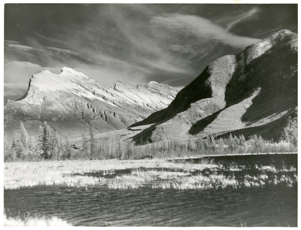
Rundle and Sulphur Mountains from Vermillion Lakes
https://archives.whyte.org/en/permalink/descriptions51633
- Part Of
- Peter and Catharine Whyte fonds
- Scope & Content
- Image of Rundle and Sulphur Mountains from the first Vermillion Lake
- Date Range
- [ca. 1920-1940]
- Reference Code
- V683 / III / A / 5 / PA - 262
- Description Level
- 6 / Image
- GMD
- Photograph
1 image
- Part Of
- Peter and Catharine Whyte fonds
- Description Level
- 6 / Image
- Fonds Number
- M36 / V683 / S37
- Series
- V683 / III / A / 5 : Peter and Catharine Whyte: Landscapes
- Sous-Fonds
- V683
- Accession Number
- .
- Reference Code
- V683 / III / A / 5 / PA - 262
- GMD
- Photograph
- Date Range
- [ca. 1920-1940]
- Physical Description
- Photograph: 1 print ; b&w.
- Scope & Content
- Image of Rundle and Sulphur Mountains from the first Vermillion Lake
- Subject Access
- Mountains
- Rundle Mountain
- Sulphur Mountain
- Vermillion Lakes
- Geographic Access
- Banff National Park
- Language
- English
- Title Source
- Title based on item
- Processing Status
- Processed
Images
This material is presented as originally created; it may contain outdated cultural descriptions and
potentially offensive content.
Read more.
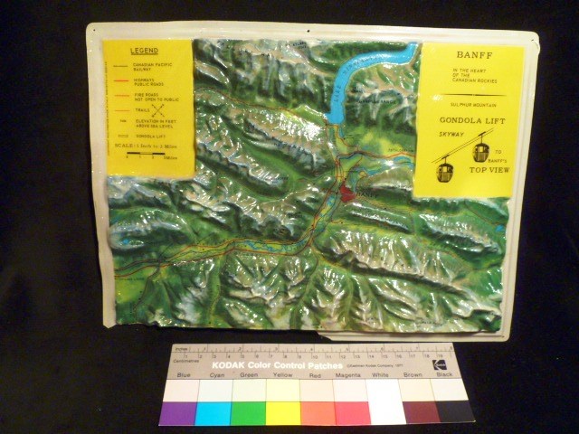
Topographical Map
https://archives.whyte.org/en/permalink/artifact105.02.1181
- Date
- n.d.
- Material
- plastic; paint;
- Catalogue Number
- 105.02.1181
- Description
- The topographical relief map details in colour Banff and the surrounding area, including all waterways, mountain ranges and individual mountains. On the top viewer left corner there is a yellow legend that reads “LEGEND” (underlined); “CANADIAN PACIFIC RAILWAY”; “HIGHWAYS PUBLIC ROADS”; “FIRE ROADS…
1 image
- Title
- Topographical Map
- Date
- n.d.
- Material
- plastic; paint;
- Dimensions
- 2.0 x 22.0 x 30.0 cm
- Description
- The topographical relief map details in colour Banff and the surrounding area, including all waterways, mountain ranges and individual mountains. On the top viewer left corner there is a yellow legend that reads “LEGEND” (underlined); “CANADIAN PACIFIC RAILWAY”; “HIGHWAYS PUBLIC ROADS”; “FIRE ROADS NOT OPEN TO PUBLIC”; “TRAILS” (with a compass next to it); “ELEVATION IN FEET ABOVE SEA LEVEL”; “GONDOLA LIFT”; and “SCALE: 1 Inch to 3 Miles” (underneath this there is a bar scale). To the viewer left of each of the traits is the corresponding symbol indicated on the map. Perpendicular to the legend (on the viewer left) the words, “COPYRIGHT RICO FIRENZE MADE IN ITALY BREVETTO No 558142”. On the top viewer right there is another yellow box of information that reads, “BANFF”; “IN THE HEART OF THE CANADIAN ROCKIES”; a line break separates the following information: “SULPHUR MOUNTAIN” “GONDOLA LIFT” “SKYWAY TO BANFF’S TOP VIEW”. There is also a pictographic depiction of the gondola at Sulphur Mountain.
- Credit
- Gift of Nicholas Morant, Banff, 2006
- Catalogue Number
- 105.02.1181
Images
This material is presented as originally created; it may contain outdated cultural descriptions and
potentially offensive content.
Read more.