Narrow Results By
- Library - Book (including soft-cover and pamphlets) 19
- Library - Periodical 18
- Library - Maps and blueprints (unannotated; published) 9
- Map 9
- Directional Sign 2
- Club Crest 1
- Identification Sign 1
- Lantern Slide Box 1
- Library - Moving image (includes film and digital video - published) 1
- Membership Patch 1
- Offset Plate 1
- Trail Signage 1
O'Hara : stories of a beloved landscape and the people who have shaped it
https://archives.whyte.org/en/permalink/catalogue19820
- Medium
- Library - Periodical
- Published Date
- May 2019
- Author
- Ward, Meghan J.
- Publisher
- Crowfoot Media
- Call Number
- P
1 website
- Author
- Ward, Meghan J.
- Publisher
- Crowfoot Media
- Published Date
- May 2019
- Physical Description
- p.66-75
- Medium
- Library - Periodical
- Subjects
- Lake O'Hara
- Lake O'Hara Bungalow Camp
- Lake O'Hara Lodge
- Lake O'Hara region
- Lake O'Hara Trails Club
- Alpine Club of Canada
- History
- Elizabeth Parker Hut
- Abbot Pass Hut
- Hiking
- Conservation
- Abstract
- Pertains to the Lake O'Hara area including the history of its "discovery", creation of trail systems, Alpine Club of Canada activities, lodges, huts and access parameters. Includes many images from the Whyte Museum of the Canadian Rockies Archives & Library.
- Notes
- In Canadian Rockies Annual, vol.04, May 2019
- Call Number
- P
- Collection
- Archives Library
- URL Notes
- Website for Crowfoot Media - publishers of Canadian Rockies Annual
Websites
This material is presented as originally created; it may contain outdated cultural descriptions and
potentially offensive content.
Read more.
Road worthy : a second look at Banff's fire roads
https://archives.whyte.org/en/permalink/catalogue20014
- Medium
- Library - Periodical
- Published Date
- 2013
- Author
- Watt, Dillon
- Call Number
- P
1 website
- Author
- Watt, Dillon
- Responsibility
- Dillon Watt
- Published Date
- 2013
- Medium
- Library - Periodical
- Subjects
- Fires
- Automobiles
- Banff (townsite)
- Banff National Park
- Banff National Park - Roads and Trails
- History
- Abstract
- Pertians to fire roads in Banff National Park and their change in use since automobiles were allowed in the park in 1916
- Notes
- In Highline Magazine, Vol. 5, Iss. 2, Summer 2013, p. 22
- Call Number
- P
- Collection
- Archives Library
- URL Notes
- Highline website
Websites
This material is presented as originally created; it may contain outdated cultural descriptions and
potentially offensive content.
Read more.
If you build it, they will come : behind the scenes with the trail builders of the Rockies
https://archives.whyte.org/en/permalink/catalogue20028
- Medium
- Library - Periodical
- Published Date
- 2015
- Author
- Hajnrych, Taryn
- Call Number
- P
1 website
- Author
- Hajnrych, Taryn
- Responsibility
- Hajnrych, Taryn
- Published Date
- 2015
- Medium
- Library - Periodical
- Subjects
- Trails
- Volunteers
- Rocky Mountains
- Abstract
- Pertians to trail building in the Rocky Mountains with specific focus on a group founded in 1992 called the Trailminders
- Notes
- In Highline Magazine, Iss. 15, Summer 2015, p. 42 - 49
- Call Number
- P
- Collection
- Archives Library
- URL Notes
- Highline website
Websites
This material is presented as originally created; it may contain outdated cultural descriptions and
potentially offensive content.
Read more.
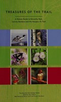
Treasures of the trail : a nature guide to Edworthy Park, Lawrey Gardens and the Douglas Fir Trail
https://archives.whyte.org/en/permalink/catalogue20078
- Medium
- Library - Book (including soft-cover and pamphlets)
- Published Date
- 2002
- Author
- Osborn, Jerry
- The Edworthy Park Heritage Society
- Publisher
- Calgary : Edworthy Park Heritage Society
- Call Number
- 04 O1t
1 website
- Responsibility
- Jerry Osborn
- The Edworthy Park Heritage Society
- Publisher
- Calgary : Edworthy Park Heritage Society
- Published Date
- 2002
- Physical Description
- 164 p. : ill. (chiefly col.), col. maps, ports.
- Subjects
- Botany
- Wildlife
- Archaeology
- History
- History of Alberta
- Maps
- Ecology
- Calgary
- Calgary, Alberta
- Walking
- Tours
- Guidebook
- Guidebooks
- Trails
- Abstract
- Pertains to Edworthy Park in Calgary, Alberta, including the geology, paleontology, plant life, animal life, insect life, archaeology, Indigenous Peoples history, settler history and maps of walks which include plant and bird checklists. The three brick plants that operated in what is now Edworthy Park: Burnvale, Brickburn, Tregillus Clay Products were used to construct many buildings in Banff.
- Contents
- Acknowledgements
- Introduction
- Geology and Paleontology
- Plant Life
- Animal Life
- Butterflies
- Archaeology and Native Culture
- History
- Park Map
- Walk One - Wester Plateau of Edworthy Park
- Walk Two - Brickburn and the Pond Lookout Trail
- Walk Three - Edworthy Park Riverside
- Walk Four - Douglas Fire Trail West
- Walk Five - Quarry Road Trail, Lawrey Gardens, and Douglas Fire Trail East
- Appendix One - Plant Checklist
- Appendix Two - Bird Checklist
- Contributors
- Further Reading
- Index of Photos
- Notes
- Brick information as per Ann Jones conversation with Lena Goon.
- ISBN
- 0973176105
- Accession Number
- 2014.8268
- Call Number
- 04 O1t
- Collection
- Archives Library
- URL Notes
- City of Calgary website re: Edworthy Park location and trail maps
Websites
This material is presented as originally created; it may contain outdated cultural descriptions and
potentially offensive content.
Read more.
Map of Banff and vicinity showing major highway, other roads, viewpoints, campgrounds, trailer park, picnic areas, lifts, trails
https://archives.whyte.org/en/permalink/catalogue21352
- Medium
- Library - Maps and blueprints (unannotated; published)
- Map
- Published Date
- ca. 1970
- Call Number
- C6-4.3(f)
- Published Date
- ca. 1970
- Notes
- Map B on reverse side of A shows the townsite in a larger scale
- file transfer
- Accession Number
- 5500
- Call Number
- C6-4.3(f)
- Collection
- Archives Library
This material is presented as originally created; it may contain outdated cultural descriptions and
potentially offensive content.
Read more.
Map showing trail outings at Banff, Spray River Valley, Tunnel Mountain area, Summit of Sulphur, Stoney Squaw Mountain, Lower Bow Valley, Sundance Canyon, Rundle Mountain
https://archives.whyte.org/en/permalink/catalogue21353
- Medium
- Library - Maps and blueprints (unannotated; published)
- Map
- Publisher
- Northern Affairs & Natural Resources
- Call Number
- C6-4.3(g)
- Publisher
- Northern Affairs & Natural Resources
- Subjects
- Banff National Park - Roads & Trails
- Notes
- Info on reverse side re: routes etc.
- Accession Number
- 2613
- Call Number
- C6-4.3(g)
- Collection
- Archives Library
This material is presented as originally created; it may contain outdated cultural descriptions and
potentially offensive content.
Read more.
Map showing trail outings at Banff, highways, trails, railway fire trail
https://archives.whyte.org/en/permalink/catalogue21354
- Subjects
- Banff National Park - Rads & Trails
- Notes
- Info on back re: "Trail Outings at Banff, Trails in the Spray River Valley, Tunnel Mtn. area, Sulphur Mtn., Stoney Squaw, Lower Bow Valley, Rundle, Sundance General info.
- Accession Number
- 2613
- Call Number
- C6-4.3(h)
- Collection
- Archives Library
This material is presented as originally created; it may contain outdated cultural descriptions and
potentially offensive content.
Read more.
Sketch map showing the vicinity of Lake Louise, Moraine Lake and Vermilion Pass
https://archives.whyte.org/en/permalink/catalogue21355
- Medium
- Library - Maps and blueprints (unannotated; published)
- Map
- Published Date
- 1905
- Publisher
- Department of the Interior
- Call Number
- C6-4.3(i)
- Publisher
- Department of the Interior
- Published Date
- 1905
- Subjects
- Lake Louise - Roads & Trails
- Notes
- Driving Roads, Pony trails
- From photographic surveys by A.O. Wheeler, Topographer of the Department assisted by M.P. Bridgland D.L.S. and H.G. Wheeler
- Accession Number
- 3120
- Call Number
- C6-4.3(i)
- Collection
- Archives Library
This material is presented as originally created; it may contain outdated cultural descriptions and
potentially offensive content.
Read more.
Map of Banff and vicinity showing major highway, other roads, viewpoints, campgrounds, trailer park, picnic areas, lifts, trails
https://archives.whyte.org/en/permalink/catalogue21382
- Medium
- Library - Maps and blueprints (unannotated; published)
- Map
- Published Date
- ca. 1970
- Call Number
- C6-4.3(f)
- Published Date
- ca. 1970
- Notes
- Map B on reverse side of A shows the townsite in a larger scale
- file transfer
- Accession Number
- 5500
- Call Number
- C6-4.3(f)
- Collection
- Archives Library
This material is presented as originally created; it may contain outdated cultural descriptions and
potentially offensive content.
Read more.
Map showing trail outings at Banff, Spray River Valley, Tunnel Mountain area, Summit of Sulphur, Stoney Squaw Mountain, Lower Bow Valley, Sundance Canyon, Rundle Mountain
https://archives.whyte.org/en/permalink/catalogue21383
- Medium
- Library - Maps and blueprints (unannotated; published)
- Map
- Publisher
- Northern Affairs & Natural Resources
- Call Number
- C6-4.3(g)
- Publisher
- Northern Affairs & Natural Resources
- Subjects
- Banff National Park - Roads & Trails
- Notes
- Info on reverse side re: routes etc.
- Accession Number
- 2613
- Call Number
- C6-4.3(g)
- Collection
- Archives Library
This material is presented as originally created; it may contain outdated cultural descriptions and
potentially offensive content.
Read more.