Narrow Results By
The Adirondacks
https://archives.whyte.org/en/permalink/catalogue3594
- Medium
- Library - Book (including soft-cover and pamphlets)
- Published Date
- 1917
- Author
- Longstreth, T. Morris
- Call Number
- 02.3 L86
- Author
- Longstreth, T. Morris
- Published Date
- 1917
- Subjects
- United States
- Call Number
- 02.3 L86
- Collection
- Archives Library
This material is presented as originally created; it may contain outdated cultural descriptions and
potentially offensive content.
Read more.
The adventures of James Capen Adams : mountaineer and grizzly bear hunter of California
https://archives.whyte.org/en/permalink/catalogue15291
- Medium
- Library - Book (including soft-cover and pamphlets)
- Published Date
- 1911
- Author
- Hittell, Theodore Henry
- Publisher
- New York : Charles Scribner's Sons
- Edition
- Illustrated new edition
- Call Number
- 01.3 H63a
- Author
- Hittell, Theodore Henry
- Edition
- Illustrated new edition
- Publisher
- New York : Charles Scribner's Sons
- Published Date
- 1911
- Physical Description
- xiii, 373 pages, illustrations (unnumbered plates)
- Subjects
- Bears, Grizzly
- United States
- Accession Number
- 492
- Call Number
- 01.3 H63a
- Collection
- Archives Library
This material is presented as originally created; it may contain outdated cultural descriptions and
potentially offensive content.
Read more.
Atlas of the international boundary between the United States and Canada Arctic Ocean to Mount St. Elias to accompany the report of the International Boundary Commission
https://archives.whyte.org/en/permalink/catalogue25066
- Medium
- Library - Map
- Published Date
- 1913
- Author
- Department of the Interior
- Publisher
- US Geological Survey
- Call Number
- 03.1 In8 OS
- Variant Title
- Joint maps of the International Boundary between United States and Canada along the 141st meridian from the Arctic Ocean to Mt. St. Elias - surveyed and monumented 1907 - 1913 under the convention signed at Washington April 21st 1906
- Author
- Department of the Interior
- Responsibility
- O.H. Tittmann 1906-1915 (United States Commissioner)
- E.C. Barnard 1915- (United States Commissioner)
- W.F. King 1906-1916 (His British Majesty's Commissioner)
- J.J. McArthur 1917- (His British Majesty's Commissioner)
- Publisher
- US Geological Survey
- Published Date
- 1913
- Physical Description
- atlas (38 leaves of plates : maps)
- Scale
- 1:62500
- Medium
- Library - Map
- Subjects
- Atlases
- Canada
- United States
- Surveys
- Surveys and Mapping
- Abstract
- Atlas to accompany "Joint report upon the survey and demarcation of the international boundary between the United States and Canada along the 141st meridian from the Arctic Ocean to Mount St. Elias : in accordance with the provisions of Article IV of the Convention signed at Washington April 21, 1906"
- Notes
- Atlas only - report separate - 03.1 In8
- Call Number
- 03.1 In8 OS
- Collection
- Archives Library
This material is presented as originally created; it may contain outdated cultural descriptions and
potentially offensive content.
Read more.
Dogs of the North
https://archives.whyte.org/en/permalink/catalogue24916
- Medium
- Library - Book (including soft-cover and pamphlets)
- Published Date
- 1914
- Author
- Browne, Belmore
- Publisher
- Outing
- Call Number
- 02.3 B35d PAM
1 website
- Author
- Browne, Belmore
- Responsibility
- Belmore Browne
- Publisher
- Outing
- Published Date
- 1914
- Subjects
- Dogs
- Dogsledding
- Travel
- Alaska
- Alaska, United States
- Browne, Belmore
- Authors
- Hunting
- Art
- Artists
- Abstract
- Pertains to the use of dogs for travel and moving freight in Alaska as observed by Belmore Browne during his travels - includes illustrations by Belmore Browne
- Notes
- In Outing, Vol. LXIII, No.6 , March 1914, pp. 643 - 658
- Accession Number
- 7889
- Call Number
- 02.3 B35d PAM
- Collection
- Archives Library
- URL Notes
- Article available online at via Hathi Trust and University of Michigan
Websites
This material is presented as originally created; it may contain outdated cultural descriptions and
potentially offensive content.
Read more.
The Great Lakes and the States that Bound Them
https://archives.whyte.org/en/permalink/artifactwyp.03.514
- Date
- 1917 – 1966
- Medium
- ink on paper
- Catalogue Number
- WyP.03.514
- Description
- Ink drawing of a geographic perspective of the Great Lakes region, including the states that border on Canada
1 image
- Title
- The Great Lakes and the States that Bound Them
- Date
- 1917 – 1966
- Medium
- ink on paper
- Dimensions
- 15.1 x 22.5 cm
- Description
- Ink drawing of a geographic perspective of the Great Lakes region, including the states that border on Canada
- Subject
- map
- Great Lakes
- Canada
- United States
- geography
- Credit
- Gift of Catharine Robb Whyte, O. C., Banff, 1975
- Catalogue Number
- WyP.03.514
Images

This material is presented as originally created; it may contain outdated cultural descriptions and
potentially offensive content.
Read more.
Green trails and upland pastures
https://archives.whyte.org/en/permalink/catalogue3574
- Medium
- Library - Book (including soft-cover and pamphlets)
- Published Date
- c1917
- Author
- Eaton, Walter Prichard
- Call Number
- 02.3 Ea8
- Author
- Eaton, Walter Prichard
- Published Date
- c1917
- Subjects
- United States
- Call Number
- 02.3 Ea8
- Collection
- Archives Library
This material is presented as originally created; it may contain outdated cultural descriptions and
potentially offensive content.
Read more.
Topographical maps
https://archives.whyte.org/en/permalink/catalogue24820
- Medium
- Library - Maps and blueprints (unannotated; published)
- Map
- Published Date
- 1914
- Publisher
- U.S. Geological Survey
- Call Number
- C13.12(a)
- Publisher
- U.S. Geological Survey
- Published Date
- 1914
- Scale
- Scale: 1:125,000
- Relief: Counter interval 100'
- Subjects
- Montana, United States
- Notes
- Chief Mountain. Browning
- Accession Number
- 718
- Call Number
- C13.12(a)
- Collection
- Archives Library
This material is presented as originally created; it may contain outdated cultural descriptions and
potentially offensive content.
Read more.
- Date
- 1917 – 1966
- Medium
- ink; graphite on paper
- Catalogue Number
- WyP.03.521
- Description
- An ink and pencil drawing of the USA, with the Great Lakes shaded in. Various locations are marked.Verso: a pencil drawing of a pocket watch showing the time to be 8 O’clock.
1 image
- Title
- Untitled
- Date
- 1917 – 1966
- Medium
- ink; graphite on paper
- Dimensions
- 15.1 x 22.5 cm
- Description
- An ink and pencil drawing of the USA, with the Great Lakes shaded in. Various locations are marked.Verso: a pencil drawing of a pocket watch showing the time to be 8 O’clock.
- Subject
- pocket watch
- clock
- USA
- United States
- Great Lakes
- Credit
- Gift of Catharine Robb Whyte, O. C., Banff, 1975
- Catalogue Number
- WyP.03.521
Images

This material is presented as originally created; it may contain outdated cultural descriptions and
potentially offensive content.
Read more.
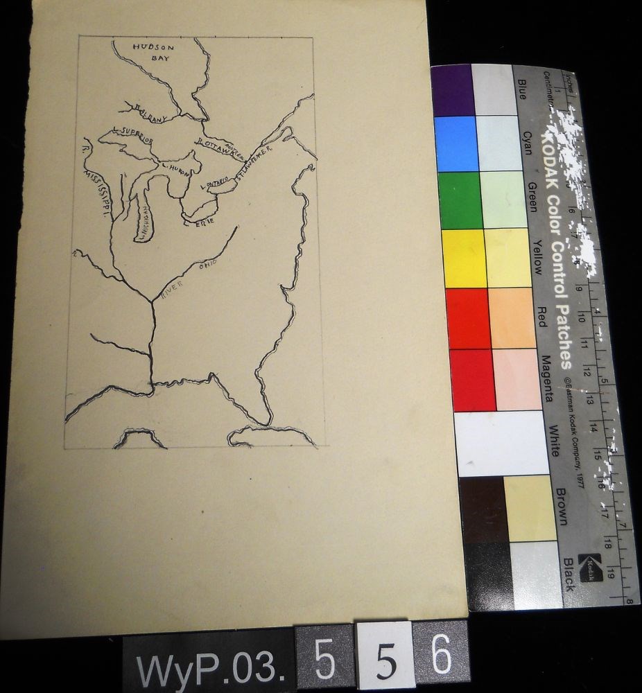
- Date
- 1917 – 1929
- Medium
- graphite; ink on paper
- Catalogue Number
- WyP.03.556
- Description
- A pencil and ink drawing of a map of Hudson Bay and the river system in eastern Canada and United States. Includes Great Lakes as well. Bodies of water are labeled.
1 image
- Title
- Untitled
- Date
- 1917 – 1929
- Medium
- graphite; ink on paper
- Dimensions
- 22.5 x 15.1 cm
- Description
- A pencil and ink drawing of a map of Hudson Bay and the river system in eastern Canada and United States. Includes Great Lakes as well. Bodies of water are labeled.
- Subject
- Canada
- Hudson Bay
- rivers
- United States
- U.S.A.
- map
- Credit
- Gift of Catharine Robb Whyte, O. C., Banff, 1979
- Catalogue Number
- WyP.03.556
Images
This material is presented as originally created; it may contain outdated cultural descriptions and
potentially offensive content.
Read more.