Narrow Results By
Map showing the northern paortion of Vancouver Island
https://archives.whyte.org/en/permalink/catalogue24531
- Medium
- Library - Maps and blueprints (unannotated; published)
- Map
- Published Date
- 1919
- Publisher
- Dept. of Lands/Honourable T.D. Pattullo. J.E. Umbach Surveyor General
- Call Number
- C10-5.1
- Publisher
- Dept. of Lands/Honourable T.D. Pattullo. J.E. Umbach Surveyor General
- Published Date
- 1919
- Scale
- Scale: 4 miles - 1 inch
- Subjects
- British Columbia
- Vancouver Island
- Accession Number
- 400
- Call Number
- C10-5.1
- Collection
- Archives Library
This material is presented as originally created; it may contain outdated cultural descriptions and
potentially offensive content.
Read more.
Geological survey [Sooke sheet - Vancouver Island]
https://archives.whyte.org/en/permalink/catalogue24741
- Medium
- Library - Book (including soft-cover and pamphlets)
- Map
- Published Date
- 1918
- Publisher
- Dept. of Mines
- Call Number
- C7-3.10
- Publisher
- Dept. of Mines
- Published Date
- 1918
- Physical Description
- 1 map : col
- Scale
- Scale: 1:125,000
- Relief: Contour interval 100 ft.
- Subjects
- Sooke Sheet - Vancouver Island
- Accession Number
- 400
- Call Number
- C7-3.10
- Collection
- Archives Library
This material is presented as originally created; it may contain outdated cultural descriptions and
potentially offensive content.
Read more.
[Duncan Sheet, Vancouver Island]
https://archives.whyte.org/en/permalink/catalogue24742
- Medium
- Library - Book (including soft-cover and pamphlets)
- Map
- Published Date
- 1917
- Call Number
- C7-3.13
- Published Date
- 1917
- Physical Description
- 1 map : col
- Scale
- Scale: 1:125,000
- Relief: contour interval 100 ft.
- Subjects
- Duncan Sheet, Vancouver Island
- Call Number
- C7-3.13
- Collection
- Archives Library
This material is presented as originally created; it may contain outdated cultural descriptions and
potentially offensive content.
Read more.
Geological Survey [Duncan Sheet - Vancouver Island]
https://archives.whyte.org/en/permalink/catalogue24743
- Medium
- Library - Book (including soft-cover and pamphlets)
- Map
- Published Date
- 1918
- Publisher
- Department of Mines
- Call Number
- C7-3.14
- Publisher
- Department of Mines
- Published Date
- 1918
- Physical Description
- 1 map : col
- Scale
- Scale: 1:25,000
- Relief: Contour interval 100 ft.
- Subjects
- Duncan Sheet, Vancouver Island
- Accession Number
- 400
- Call Number
- C7-3.14
- Collection
- Archives Library
This material is presented as originally created; it may contain outdated cultural descriptions and
potentially offensive content.
Read more.
Geological survey [Victoria Sheet - Vancouver Island]
https://archives.whyte.org/en/permalink/catalogue24744
- Medium
- Library - Book (including soft-cover and pamphlets)
- Map
- Published Date
- 1915
- Publisher
- Department of Mines
- Call Number
- C7-3.15
- Publisher
- Department of Mines
- Published Date
- 1915
- Physical Description
- 1 map : col
- Scale
- Scale: 1:62,500
- Contour interval 20 ft.
- Subjects
- Victoria sheet - Vancouver Island
- Accession Number
- 400
- Call Number
- C7-3.15
- Collection
- Archives Library
This material is presented as originally created; it may contain outdated cultural descriptions and
potentially offensive content.
Read more.
Hand-I-maps of Vancouver Island and Victoria
https://archives.whyte.org/en/permalink/catalogue20003
- Medium
- Library - Book (including soft-cover and pamphlets)
- Publisher
- Victoria, B.C. : The Island Blue Print and Map
- Call Number
- 02.5 Is4h Pam
- Publisher
- Victoria, B.C. : The Island Blue Print and Map
- Abstract
- Pertains to a series of small maps and information regarding travel in Vancouver Island and Victoria, British Columbia. The booklet includes maps outlining Vancouver Island and Victoria, as well as short collections of information pertaining to specific locations within the locations such as, Nanaimo, Parksville, Qualicum Beach, Courtenay and Comox.
- Accession Number
- 7201
- Call Number
- 02.5 Is4h Pam
- Collection
- Archives Library
This material is presented as originally created; it may contain outdated cultural descriptions and
potentially offensive content.
Read more.
Geological map [Vancouver Island], Northern part of Vancouver Island and adjacent coast
https://archives.whyte.org/en/permalink/catalogue21464
- Medium
- Library - Book (including soft-cover and pamphlets)
- Map
- Published Date
- 1887
- Publisher
- Geological and Natural History Survey of Canada
- Call Number
- C7-3.9
- Publisher
- Geological and Natural History Survey of Canada
- Published Date
- 1887
- Subjects
- Vancouver Island
- Call Number
- C7-3.9
- Collection
- Archives Library
This material is presented as originally created; it may contain outdated cultural descriptions and
potentially offensive content.
Read more.
Geological survey [East Sooke, Vancouver Island]
https://archives.whyte.org/en/permalink/catalogue15487
- Medium
- Library - Book (including soft-cover and pamphlets)
- Map
- Published Date
- 1913
- Publisher
- Department of Mines
- Call Number
- C7-3.12
- Publisher
- Department of Mines
- Published Date
- 1913
- Scale
- Scale: 1:24,000
- Relief: Contour interval 20 ft.
- Subjects
- East Sooke, Vancouver Island
- Accession Number
- 400
- Call Number
- C7-3.12
- Collection
- Archives Library
This material is presented as originally created; it may contain outdated cultural descriptions and
potentially offensive content.
Read more.
- Date
- 1943 – 1944
- Medium
- oil on canvas
- Catalogue Number
- WyC.01.178
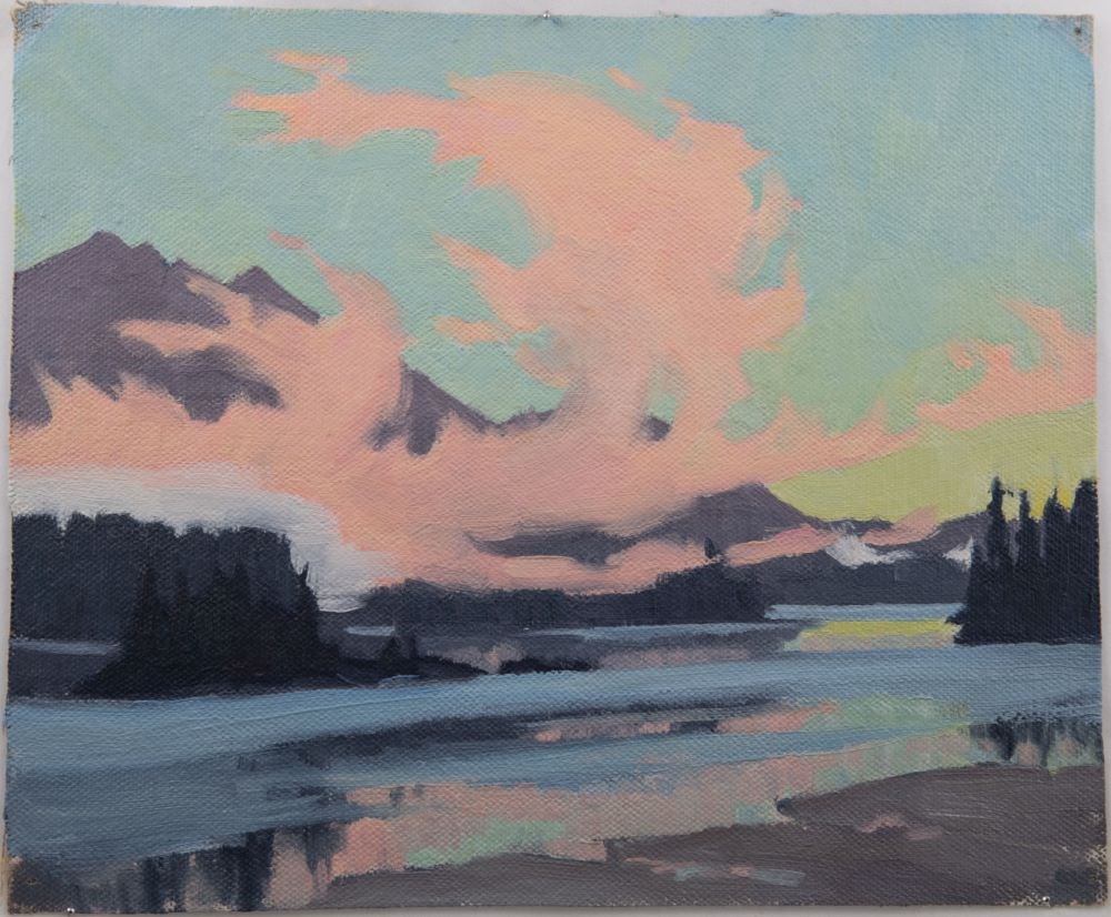
- Description
- Tofino sunset depicting pink clouds and pale sky.
1 image
- Title
- Tofino Sunset
- Date
- 1943 – 1944
- Medium
- oil on canvas
- Dimensions
- 22.8 x 28.0 cm
- Description
- Tofino sunset depicting pink clouds and pale sky.
- Subject
- landscape
- Vancouver Island
- Tofino
- seascape
- Pacific
- Credit
- Gift of Catharine Robb Whyte, O. C., Banff, 1979
- Catalogue Number
- WyC.01.178
Images
This material is presented as originally created; it may contain outdated cultural descriptions and
potentially offensive content.
Read more.
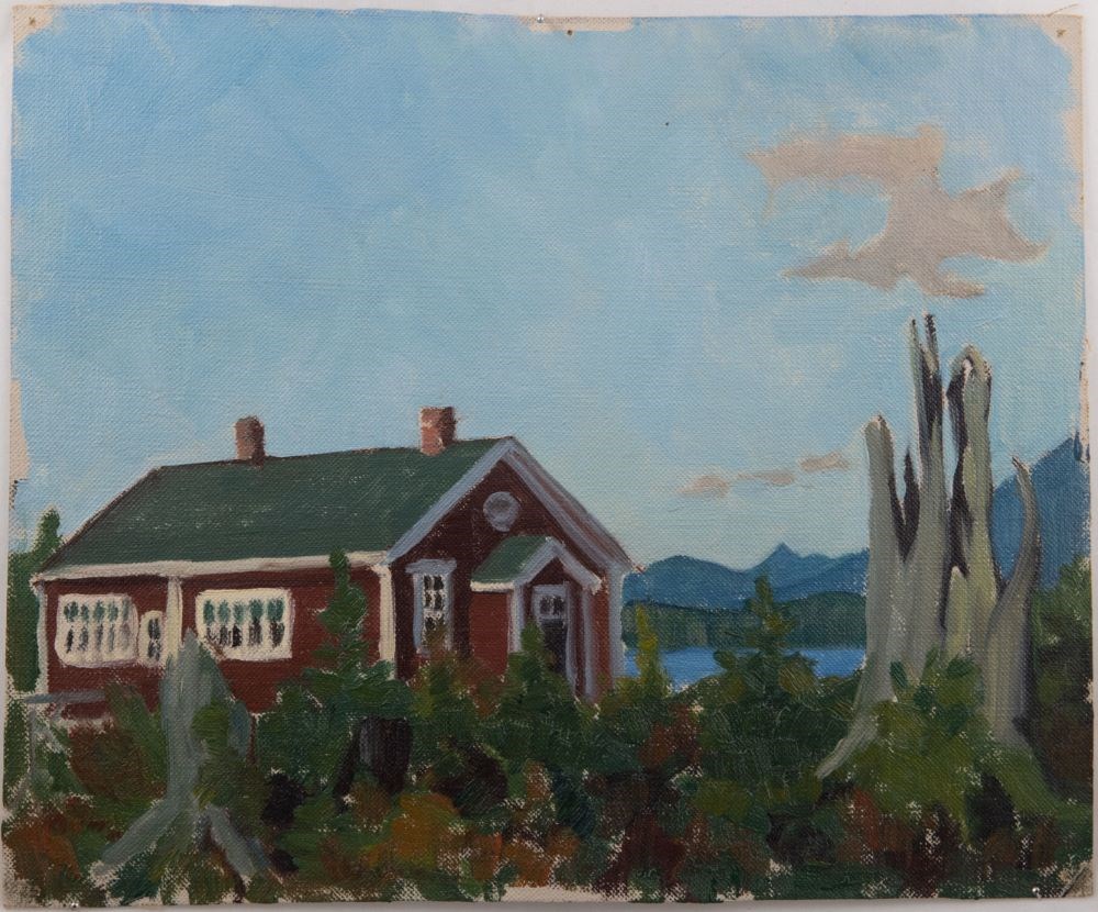
Tofino Schoolhouse
https://archives.whyte.org/en/permalink/artifactwyc.01.179
- Date
- 1943 – 1944
- Medium
- oil on canvas
- Catalogue Number
- WyC.01.179
- Description
- Red and white schoolhouse at Tofino.
1 image
- Title
- Tofino Schoolhouse
- Date
- 1943 – 1944
- Medium
- oil on canvas
- Dimensions
- 22.8 x 28.0 cm
- Description
- Red and white schoolhouse at Tofino.
- Credit
- Gift of Catharine Robb Whyte, O. C., Banff, 1979
- Catalogue Number
- WyC.01.179
Images
This material is presented as originally created; it may contain outdated cultural descriptions and
potentially offensive content.
Read more.