Narrow Results By
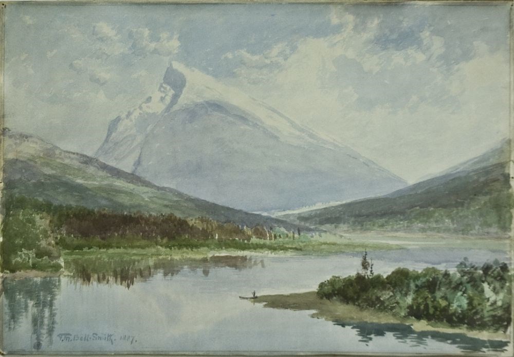
Mt. Rundle, Vermilion Lakes, Banff, N.W.T.
https://archives.whyte.org/en/permalink/artifactbes.05.06
- Date
- 1887
- Medium
- watercolour on paper
- Catalogue Number
- BeS.05.06
- Description
- Mt. Rundle with Vermilion Lakes in foreground. A figure in a canoe is on the shore of the lake in the lower centre of image.
1 image
- Title
- Mt. Rundle, Vermilion Lakes, Banff, N.W.T.
- Date
- 1887
- Medium
- watercolour on paper
- Dimensions
- 33.5 x 48.6 cm
- Description
- Mt. Rundle with Vermilion Lakes in foreground. A figure in a canoe is on the shore of the lake in the lower centre of image.
- Credit
- Gift of Ted and Judy Mills, Mill Bay, 2005
- Catalogue Number
- BeS.05.06
Images
This material is presented as originally created; it may contain outdated cultural descriptions and
potentially offensive content.
Read more.
Sketch map of Vermilion Lakes used inn Bow Valley Interpretive Unit Study
https://archives.whyte.org/en/permalink/catalogue21368
- Medium
- Library - Maps and blueprints (unannotated; published)
- Map
- Call Number
- C6-11.3(b)
- Subjects
- Vermilion Lakes
- B.N.P.
- Accession Number
- 3138
- Call Number
- C6-11.3(b)
- Collection
- Archives Library
This material is presented as originally created; it may contain outdated cultural descriptions and
potentially offensive content.
Read more.
Sketch map of Vermilion Lakes used inn Bow Valley Interpretive Unit Study
https://archives.whyte.org/en/permalink/catalogue21398
- Medium
- Library - Maps and blueprints (unannotated; published)
- Map
- Call Number
- C6-11.3(b)
- Subjects
- Vermilion Lakes
- B.N.P.
- Accession Number
- 3138
- Call Number
- C6-11.3(b)
- Collection
- Archives Library
This material is presented as originally created; it may contain outdated cultural descriptions and
potentially offensive content.
Read more.
Sketch map of Vermillion Lakes used in Vermillion Lakes, Banff National Park Study by Bow Valley Naturalists with the support of Parks Canada
https://archives.whyte.org/en/permalink/catalogue24363
- Medium
- Library - Maps and blueprints (unannotated; published)
- Map
- Published Date
- Drawn (1974) using 1958, 1965 air photos. by D.J.S.
- Call Number
- C6-11.3
- Published Date
- Drawn (1974) using 1958, 1965 air photos. by D.J.S.
- Scale
- 1:13,200
- Subjects
- Vermilion Lakes
- B.N.P.
- Accession Number
- 2982
- Call Number
- C6-11.3
- Collection
- Archives Library
This material is presented as originally created; it may contain outdated cultural descriptions and
potentially offensive content.
Read more.
Sketch map of Vermillion Lakes used in Vermillion Lakes, Banff National Park Study by Bow Valley Naturalists with the support of Parks Canada
https://archives.whyte.org/en/permalink/catalogue23430
- Medium
- Library - Maps and blueprints (unannotated; published)
- Map
- Published Date
- Drawn (1974) using 1958, 1965 air photos. by D.J.S.
- Call Number
- C6-11.3
- Published Date
- Drawn (1974) using 1958, 1965 air photos. by D.J.S.
- Scale
- 1:13,200
- Subjects
- Vermilion Lakes
- B.N.P.
- Accession Number
- 2982
- Call Number
- C6-11.3
- Collection
- Archives Library
This material is presented as originally created; it may contain outdated cultural descriptions and
potentially offensive content.
Read more.