Narrow Results By
- Luxton family fonds 67
- Byron Harmon fonds 28
- Jean A. Hembroff MacDonald fonds 13
- Alpine Club of Canada fonds 12
- Archives General File Collection 11
- Bert Riggall fonds 11
- Dorothy Wardle fonds 9
- Lillian Gest fonds 9
- Arthur Oliver Wheeler fonds 7
- Peter and Catharine Whyte fonds 7
- Bob Hind fonds 4
- Soapy Smith fonds 4
The golden grindstone : the adventures of George M. Mitchell
https://archives.whyte.org/en/permalink/catalogue26172
- Medium
- Library - Book (including soft-cover and pamphlets)
- Published Date
- 1935
- Publisher
- Toronto : Oxford University Press, Canadian Branch
- Call Number
- 08.2 G76g
- Responsibility
- Recorded by Angus Graham
- Publisher
- Toronto : Oxford University Press, Canadian Branch
- Published Date
- 1935
- Contents
- I. The general idea -- II. The geographical problem -- III. The immigrant train -- IV. Edmonton -- V. Athbasca landing -- VI. The Athabasca River -- VII. Grand rapids -- VIII. The Slave River -- IX. Great Slave Lake -- X. Fort Simpson -- XI. The Mackenzie River -- XII. Fort McPherson --XIII. The Eskimo -- XIV. The first traffic with the Indians -- XV. The Peel River -- The upper Peel River and the valley of noises -- XVII. Gold -- XVIII. The winter camp -- XIX. Prospecting and exploration -- XX. Bears and wolves -- XXI. The winter night -- XXII. The Indians' visit -- XXIII. Dogs -- XXIV. The broken knee -- XXV. The last of the white men -- XXVI. The Indian Camp -- XXVI. The Indian Camp -- XXVII. Caribou -- XXVIII. The old lady -- XXIX. Famine and riot -- XXX. Mitchell becomes an Indian -- XXXI. An Indian "Veillee" -- XXXII. Women -- XXXIII. The closest shave of all -- XXXIV. The skin boats -- XXXV. Summer hunting -- XXXVI. Mitchell remains an Indian -- XXXVII. The last of the Indians.
- Accession Number
- 2023.47
- Call Number
- 08.2 G76g
- Collection
- Archives Library
This material is presented as originally created; it may contain outdated cultural descriptions and
potentially offensive content.
Read more.
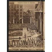
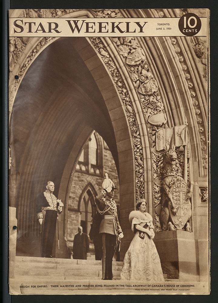
British royal family [1939 - 1940]
https://archives.whyte.org/en/permalink/descriptions22395
- Part Of
- Luxton family fonds
- Scope & Content
- Scrapbook consists of a Star Weekly, 1939 magazine publication about Queen Elizabeth and King Edward VI. Also included are newspaper clippings relating to "Know Your Empire" Contest, 1940.
- Date Range
- 1939-1940
- Reference Code
- LUX / III / B4 - 11
- Description Level
- 5 / File
- GMD
- Textual record
- Scrapbook
1 image
1 Electronic Resource
- Part Of
- Luxton family fonds
- Description Level
- 5 / File
- Fonds Number
- LUX
- Series
- III.B.4. Georgina Luxton : Collected Material : Textual Records
- Sous-Fonds
- III. Luxton Family sous-fonds
- Accession Number
- LUX
- Reference Code
- LUX / III / B4 - 11
- Date Range
- 1939-1940
- Physical Description
- 1 cm of textual records
- Scope & Content
- Scrapbook consists of a Star Weekly, 1939 magazine publication about Queen Elizabeth and King Edward VI. Also included are newspaper clippings relating to "Know Your Empire" Contest, 1940.
- Subject Access
- Royalty
- Royal Visit
- Politics
- Public events
- Regalia
- Industry
- Ship
- Travel
- Geographic Access
- Canada
- British Columbia
- Vancouver
- England
- London
- Access Restrictions
- Copyright status unknown
- Reproduction Restrictions
- Copyright status unknown
- Language
- English
- Conservation
- Metal rings removed from binding and replaced with unbleached string to protect materials from rust damage
- Two loose items have been stored in mylar
- Title Source
- Title based on contents of item
- Processing Status
- Processed
Electronic Resources
Images
This material is presented as originally created; it may contain outdated cultural descriptions and
potentially offensive content.
Read more.
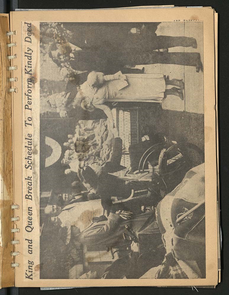
Queen Elizabeth and King George VI 1939 Canada tour
https://archives.whyte.org/en/permalink/descriptions22396
- Part Of
- Luxton family fonds
- Scope & Content
- Scrapbook consists of newspaper clippings about Queen Elizabeth and King George VI's 1939 Royal Tour across Canada.
- Date Range
- 1939
- Reference Code
- LUX / III / B4 - 12
- Description Level
- 5 / File
- GMD
- Textual record
- Scrapbook
1 image
1 Electronic Resource
- Part Of
- Luxton family fonds
- Description Level
- 5 / File
- Fonds Number
- LUX
- Series
- III.B.4. Georgina Luxton : Collected Material : Textual Records
- Sous-Fonds
- III. Luxton Family sous-fonds
- Accession Number
- LUX
- Reference Code
- LUX / III / B4 - 12
- Date Range
- 1939
- Physical Description
- 2 cm of textual records
- Scope & Content
- Scrapbook consists of newspaper clippings about Queen Elizabeth and King George VI's 1939 Royal Tour across Canada.
- Subject Access
- Royal Visit
- Royal tours
- Public events
- Community events
- Churches
- Travel
- Geographic Access
- Canada
- Alberta
- Banff
- Jasper
- Calgary
- Manitoba
- Winnipeg
- Ontario
- Toronto
- British Columbia
- Vancouver
- United States of America
- New York
- Language
- English
- Title Source
- Title based on contents of item
- Processing Status
- Processed
Electronic Resources
Images
This material is presented as originally created; it may contain outdated cultural descriptions and
potentially offensive content.
Read more.
King George VI and British royal family [ca. 1935 - 1951]
https://archives.whyte.org/en/permalink/descriptions22399
- Part Of
- Luxton family fonds
- Scope & Content
- Scrapbook consists of newspaper clippings pertaining to King George VI's coronation and Queen Elizabeth; newspaper clippings relating to British West Indies, Australia and other Empire colonies as well as related stories. Scrapbook also includes articles relating to King George VI and family. Also …
- Date Range
- [1935-1940]
- 1939
- 1951
- Reference Code
- LUX / III / B4 - 15
- Description Level
- 5 / File
- GMD
- Textual record
- Scrapbook
- Postcard
- Published record
1 image
1 Electronic Resource
- Part Of
- Luxton family fonds
- Description Level
- 5 / File
- Fonds Number
- LUX
- Series
- III.B.4. Georgina Luxton : Collected Material : Textual Records
- Sous-Fonds
- III. Luxton Family sous-fonds
- Accession Number
- LUX
- Reference Code
- LUX / III / B4 - 15
- Date Range
- [1935-1940]
- 1939
- 1951
- Physical Description
- 3 cm of textual records
- Scope & Content
- Scrapbook consists of newspaper clippings pertaining to King George VI's coronation and Queen Elizabeth; newspaper clippings relating to British West Indies, Australia and other Empire colonies as well as related stories. Scrapbook also includes articles relating to King George VI and family. Also included are two file folders containing:
- four postcards bearing images of the King and Queen's visit to Belfast, troops inspections and two publications titled: "Their Majesties' Canadian Visit, 1939" and a timetable of Pilot train and boats and itinerary of activities [placed in a mylar sleeve and file folder].
- booklet and b&w photographs relating to King George VI and Queen Elizabeth's Royal Visit, 1939 [placed in a file folder].
- Subject Access
- Politics
- Public events
- Royal tours
- Royal Visit
- Royalty
- Trains
- Travel
- Newspaper
- Publication
- Geographic Access
- Canada
- Alberta
- Banff National Park
- Jasper
- England
- London
- Access Restrictions
- Restrictions may apply
- Reproduction Restrictions
- Restrictions may apply
- Language
- English
- Conservation
- Postcard prints and other inserts have been placed in mylar inside scrapbook
- Title Source
- Title based on contents of item
- Processing Status
- Processed
Electronic Resources
Images
This material is presented as originally created; it may contain outdated cultural descriptions and
potentially offensive content.
Read more.
Personal Documents
https://archives.whyte.org/en/permalink/descriptions23022
- Part Of
- Hans Gmoser fonds
- Scope & Content
- One of three files pertaining to Personal Documents.
- Date Range
- 1880-2013
- Reference Code
- M224 / 30
- Description Level
- 5 / File
- Part Of
- Hans Gmoser fonds
- Description Level
- 5 / File
- Series
- IV.C. Textual records
- Accession Number
- 8111
- Reference Code
- M224 / 30
- Date Range
- 1880-2013
- Physical Description
- 2 cm of textual records.
- Scope & Content
- One of three files pertaining to Personal Documents.
- Subject Access
- Discovery and Exploration
- Environment and Nature
- Family and personal life
- Sports and Recreation
- Title Source
- Supplied title.
- Content Details
- Canadian Passport July 15, 1983-July 15, 1988 Canadian Passport June 30, 1988- June 30, 1993 Canadian Passport April 6, 1993-April 6, 1998 Canadian Passport Feb 18, 1998-Feb 18, 2003 Photocopy of Johann Wolfgang Gmoser’s Canadian Passport Jan 28, 2003-2008. Photocopy of Johann Wolfgang Gmoser’s Austrian Passport February 3, 2003-2013 Photocopy of passport? From an individual born in 1880.
- Processing Status
- Processed
This material is presented as originally created; it may contain outdated cultural descriptions and
potentially offensive content.
Read more.
Cartographic Materials
https://archives.whyte.org/en/permalink/descriptions23065
- Part Of
- Hans Gmoser fonds
- Scope & Content
- Cartographic materials in these four oversized files consist of the following:
- Date Range
- 1914-1973
- Reference Code
- M224 / O.S. Cartographic
- Description Level
- 5 / File
- Part Of
- Hans Gmoser fonds
- Description Level
- 5 / File
- Series
- IV.C. Textual records: Cartographic records
- Accession Number
- 7361, 7877, 8111
- Reference Code
- M224 / O.S. Cartographic
- Date Range
- 1914-1973
- Physical Description
- 48 cartographic records.
- Scope & Content
- Cartographic materials in these four oversized files consist of the following:
- Subject Access
- Discovery and Exploration
- Environment and Nature
- Family and personal life
- Sports and Recreation
- Title Source
- Title based on contents.
- Content Details
- Folder 1 Map on heavy paper, wrapped in plastic. “A Reconnaissance Topographic Map Suveyed and edited by Bradford Washburn” printed in Bern, Switzerland. Centred on Mt. McKinley.- From 7361. Palliser- Kananaskis Area British Columbia and Alberta- Publication No. 1962- Reprinted by the Surveys and Mapping Branch, Department of Mines and Technical Surveys, Ottawa. Mistaya British Columbia and Alberta- Compiled, drawn and printed at the office of the Surveyor General, Ottawa, 1931. Reprinted with corrections at the Surveys and Mapping Branch, Ottawa, 1950. National Topographic Series. Yoho British Columbia and Alberta- Compiled, drawn and printed at the office of the Surveyor General, Ottawa, 1932. Reprinted with corrections at the Surveys and Mapping Branch, Ottawa, 1952. National Topographic Series. Price 25 cents. Invermere British Columbia Kootenay Land District- National Topographic System- First Status Edition compiled and produced by the Geographic Division, Surveys, and Mapping Branch, Dept. of Lands, Forests and Water Resources, Victoria, BC 1964-65- annotated Beaton British Columbia Kootenay Land District- National Topographic System- First Status Edition compiled and produced by the Geographic Division, Surveys, and Mapping Branch, Dept. of Lands, Forests and Water Resources, Victoria, BC 1964-66- annotated Lardeau British Columbia Kootenay Land District- National Topographic System- First Status Edition compiled and produced by the Geographic Division, Surveys, and Mapping Branch, Dept. of Lands, Forests and Water Resources, Victoria, BC 1963- annotated Mount McKinley Alaska, Published by the Museum of Science, Boston, Mass, USA and the Swiss Foundation for Alpine Research, Zurich. 1960. Centennial Range Yukon Territory- M.C.R. 7 Edition 1- Produced and printed 1967 by the Surveys and Mapping Branch, Department of Energy, Mines and Resources- maps printed in 1961-62- annotated British Columbia Land Recording Dists.- Land Commissioner’s Offices- Department of Lands and Forests- first published 1957- Updated Nov. 1, 1960. Master Site Plan Bugaboo Creek Lodge Project number 6844- June 18, 1973- Cohos Delesalle & Evamy. Folder 2 Boundary Between Alberta and BC- Athabasca Pass- Sheet No. 27A – annotated- centered on Jasper Park Boundary Between Alberta and BC-All below Wheeler Maps (by hand) used for the Great Divide as per Chic-no topographical maps used for both Hans and similar maps were used by Chic bottom rip taped- Sheet No. 20- Drawn and printed by the Topographical Survey of Canada, Ottawa - centered on Clearwater forest and Lyell Icefield at bottom right Boundary Between Alberta and BC- Sheet No. 15- Drawn and printed at the Surveyor General’s Office, Ottawa, Canada- centered on Rocky Mountains Park Boundary Between Alberta and BC - Sheet No. 19- Drawn and printed at the Surveyor General’s Office, Ottawa, Canada- centered on centered on Clearwater Forest with Mt. Alan Campbell at bottom Boundary Between Alberta and BC- Sheet No. 25- annotated- Drawn and printed by the Topographical Survey of Canada, Ottawa - centered on Jasper Park with Chisel Peak at bottom Boundary Between Alberta and BC- Sheet No. 19- dirt and annotated- revised 1925- drawn and printed by the Topographical Survey of Canada, Ottawa- centered on Clearwater and Push Pass W. Boundary Between Alberta and BC- annotated- Sheet 16- revised 1925- drawn and printed by the Topographical Survey of Canada, Ottawa- centered on Yoho Park and Rocky Mountains Park Steele Glacier- Topographical Survey 1967 Arial Photography 1951 Mount St. Elias Canada- United State of America- Produced and Printed by the Surveys and Mapping Branch, Department of Mines and Technical Surveys 1962 from air photographs taken in 1951 and 1956- annotated Woolsey Glacier- Revelstoke National Park British Columbia – Printed by the Surveys and Mapping Branch Department of Energy, Mines and Resources- 1967 Windermere Kootenay District- Map 165A Issued 1918- Reprinted by the Surveys and Mapping Branch, Department of Mines and Technical Surveys, Ottawa. Folder 3 Boundary Between Alberta and BC- Sheet No. 20- heavily annotated- revised 1925- drawn and printed by the Topographical Survey of Canada, Ottawa- centered on Clearwater Forest, Saskatchewan Glacier at top left Boundary Between Alberta and BC- Sheet No. 18- heavily ripped- annotated - notes on back- revised 1925- drawn and printed by the Topographical Survey of Canada, Ottawa- centered on Clearwater Forest, Mt Mummery at bottom Boundary Between Alberta and BC- Sheet No. 17 (in pencil “A and B”)- annotated - heavily ripped- drawn and printed at the Surveyor Generals’ Office- centered on Clearwater Forest and Yoho Park Boundary Between Alberta and BC- Sheet No. 26- annotated- revised 1925- drawn and printed by the Topographical Survey of Canada, Ottawa- centered on Jasper Park and Icefields Boundary Between Alberta and BC- Sheet No. 17- revised 1925- drawn and printed by the Topographical Survey of Canada, Ottawa- centered on Clearwater Forest and Yoho Park Boundary Between Alberta and BC- Sheet No. 28- stained- centered on Jasper Park Boundary Between Alberta and BC- Sheet No. 24- annotated- revised edition, 1925- drawn and printed by the Topographical Survey of Canada, Ottawa- centered on Jasper Park Boundary Between Alberta and BC- Sheet No. 16- annotated- revised 1925- drawn and printed by the Topographical Survey of Canada, Ottawa- centered on Yoho and Rocky Mountains Park Interprovincial Boundary Commission Boundary Between Alberta and British Columbia. Revised edition 1925 drawn and printed by the Topographical Survey of Canada, Ottawa. Sheet No. 27. Following maps are from accession 7877. Interprovincial Boundary Commission Boundary Between Alberta and British Columbia. Surveyed 1920. Drawn and printed by the Topographical Survey of Canada, Ottawa. Sheet No. 26. Interprovincial Boundary Commission Boundary Between Alberta and British Columbia. Surveyed 1920, 1921. Drawn and printed by the Topographical Survey of Canada, Ottawa. Sheet No. 25. Interprovincial Boundary Commission Boundary Between Alberta and British Columbia. Surveyed 1919, 1921. Drawn and printed by the Topographical Survey of Canada, Ottawa. Sheet No. 24. Interprovincial Boundary Commission Boundary Between Alberta and British Columbia. Revised edition 1925 drawn and printed by the Topographical Survey of Canada, Ottawa. Sheet No. 21. Interprovincial Boundary Commission Boundary Between Alberta and British Columbia. Revised edition 1925 drawn and printed by the Topographical Survey of Canada, Ottawa. Sheet No. 18. Interprovincial Boundary Commission Boundary Between Alberta and British Columbia. Surveyed 1913. Drawn and printed by the Topographical Survey of Canada, Ottawa. Sheet No. 13 A. Interprovincial Boundary Commission Boundary Between Alberta and British Columbia. Surveyed 1916. Drawn and printed by the Topographical Survey of Canada, Ottawa. Sheet No. 12 A. Interprovincial Boundary Commission Boundary Between Alberta and British Columbia. Surveyed 1916. Drawn and printed by the Topographical Survey of Canada, Ottawa. Sheet No. 11. Interprovincial Boundary Commission Boundary Between Alberta and British Columbia. Surveyed 1916. Drawn and printed by the Topographical Survey of Canada, Ottawa. Sheet No. 10. Interprovincial Boundary Commission Boundary Between Alberta and British Columbia. Surveyed 1916. Drawn and printed by the Topographical Survey of Canada, Ottawa. Sheet No. 9. Interprovincial Boundary Commission Boundary Between Alberta and British Columbia. Surveyed 1916. Drawn and printed by the Topographical Survey of Canada, Ottawa. Sheet No. 8. Interprovincial Boundary Commission Boundary Between Alberta and British Columbia. Surveyed 1916. Drawn and printed by the Topographical Survey of Canada, Ottawa. Sheet No. 6. Interprovincial Boundary Commission Boundary Between Alberta and British Columbia. Surveyed 1915. Drawn and printed by the Topographical Survey of Canada, Ottawa. Sheet No. 5. Interprovincial Boundary Commission Boundary Between Alberta and British Columbia. Surveyed 1914. Drawn and printed by the Topographical Survey of Canada, Ottawa. Sheet No. 4. Interprovincial Boundary Commission Boundary Between Alberta and British Columbia. Surveyed 1922. Drawn and printed by the Topographical Survey of Canada, Ottawa. Sheet No. 31. Interprovincial Boundary Commission Boundary Between Alberta and British Columbia. Surveyed 1922, 1924. Drawn and printed by the Topographical Survey of Canada, Ottawa. Sheet No. 30. Interprovincial Boundary Commission Boundary Between Alberta and British Columbia. Surveyed 1917. Drawn and printed by the Topographical Survey of Canada, Ottawa. Sheet No. 29.
- Processing Status
- Processed
This material is presented as originally created; it may contain outdated cultural descriptions and
potentially offensive content.
Read more.
Buildings and businesses, Banff area
https://archives.whyte.org/en/permalink/descriptions55330
- Part Of
- Luxton family fonds
- Scope & Content
- File consists of 34 photographs pertaining to businesses and other properties in and around Banff. Photographs depict individuals swimming at the Cave and Basin; a boathouse near the Bow River; several hotels, including Banff Springs Hotel, Chateau Lake Louise and the Mount Royal Hotel; Fairholme R…
- Date Range
- 1901
- [1910-1950]
- Reference Code
- LUX / III / D / PA - 1 to 34
- Description Level
- 5 / File
- GMD
- Photograph
- Photograph print
- Part Of
- Luxton family fonds
- Description Level
- 5 / File
- Fonds Number
- LUX
- Series
- LUX / III / D : Other material
- Sous-Fonds
- LUX / III : Luxton family sous-fonds
- Accession Number
- LUX
- Reference Code
- LUX / III / D / PA - 1 to 34
- Date Range
- 1901
- [1910-1950]
- Physical Description
- 34 photographs : b&w prints ; 25 x 20 cm or smaller
- Scope & Content
- File consists of 34 photographs pertaining to businesses and other properties in and around Banff. Photographs depict individuals swimming at the Cave and Basin; a boathouse near the Bow River; several hotels, including Banff Springs Hotel, Chateau Lake Louise and the Mount Royal Hotel; Fairholme Ranch; and other related views.
- Notes
- Some photographs are annotated
- Subject Access
- Businesses
- Hotels
- Animals
- Banff National Park
- Banff Upper Hot Springs
- Bow River Boat House
- Boats
- Buildings
- Cave and Basin
- Chateau Lake Louise
- Fairholme Ranch
- Mount Royal Hotel
- Postcards
- Ranches
- Teahouses
- Tourism
- Travel
- Upper Hot Springs
- Geographic Access
- Canada
- Alberta
- Banff
- Banff National Park
- Lake Louise
- Access Restrictions
- Restrictions may apply
- Reproduction Restrictions
- Copyright restrictions may apply
- Language
- English
- Conservation
- Some items stored in mylar
- Category
- Exploration, discovery and travel
- Title Source
- Title based on contents of file
- Processing Status
- Processed
This material is presented as originally created; it may contain outdated cultural descriptions and
potentially offensive content.
Read more.
Natural views, Banff area
https://archives.whyte.org/en/permalink/descriptions55331
- Part Of
- Luxton family fonds
- Scope & Content
- File consists of 66 b&w photographs and 4 colour photographs pertaining to natural views in and around Banff. Includes views of the town of Banff from Sulphur Mountain; Banff Springs Hotel; Sinclair Canyon; Marble Canyon; Emerald Lake; Mount Rundle and Tunnel Mountain; Banff Buffalo Paddock; a pack…
- Date Range
- [ca.1900-1910]
- 1902-1910
- [1920-1940]
- 1930
- 1950
- 1970
- Reference Code
- LUX / III / D / PA - 35 to 104
- Description Level
- 5 / File
- GMD
- Photograph
- Photograph print
- Part Of
- Luxton family fonds
- Description Level
- 5 / File
- Fonds Number
- LUX
- Series
- LUX / III / D : Other material
- Sous-Fonds
- LUX / III : Luxton family sous-fonds
- Accession Number
- LUX
- Reference Code
- LUX / III / D / PA - 35 to 104
- Date Range
- [ca.1900-1910]
- 1902-1910
- [1920-1940]
- 1930
- 1950
- 1970
- Physical Description
- 70 photographs : b&w and col. prints ; 28 x 18 cm or smaller
- Scope & Content
- File consists of 66 b&w photographs and 4 colour photographs pertaining to natural views in and around Banff. Includes views of the town of Banff from Sulphur Mountain; Banff Springs Hotel; Sinclair Canyon; Marble Canyon; Emerald Lake; Mount Rundle and Tunnel Mountain; Banff Buffalo Paddock; a pack trip; and related views.
- Notes
- Some items are annotated
- Subject Access
- Environment
- Travel
- Mountains
- Landscapes
- Animals
- Buffalo
- Moose
- Elk
- Animal Paddock
- Horses
- Pack trips
- Geographic Access
- Canada
- Alberta
- Banff
- Banff National Park
- Marble Canyon
- Mount Rundle
- Sulphur Mountain
- Tunnel Mountain
- British Columbia
- Sinclair Canyon
- Access Restrictions
- Restrictions may apply
- Reproduction Restrictions
- Restrictions may apply
- Language
- English
- Conservation
- Some items stored in mylar
- Title Source
- Title based on contents of file
- Processing Status
- Processed
This material is presented as originally created; it may contain outdated cultural descriptions and
potentially offensive content.
Read more.
Bow Valley area, mountain ranges and views
https://archives.whyte.org/en/permalink/descriptions55530
- Part Of
- Luxton family fonds
- Scope & Content
- File consists of 34 photographs depicting views of the Bow Valley and surrounding areas, and Quebec. Depicted locations include Chinaman's Peak (now Ha Ling), End Mountain, Fairholme Range, Mount McDougall, Mount Chester, Mount Galatea, Fisher Range in Kananaskis, Mount Lougheed and Mount Sparrowha…
- Date Range
- 1938-1939
- Reference Code
- LUX / III / D / PA - 171 to 204
- Description Level
- 5 / File
- GMD
- Photograph
- Part Of
- Luxton family fonds
- Description Level
- 5 / File
- Fonds Number
- LUX
- Series
- LUX / III / D : Other material
- Sous-Fonds
- LUX / III : Luxton family sous-fonds
- Accession Number
- LUX
- Reference Code
- LUX / III / D / PA - 171 to 204
- GMD
- Photograph
- Date Range
- 1938-1939
- Physical Description
- 34 photographs : b&w prints ; 11 x 7 cm
- Scope & Content
- File consists of 34 photographs depicting views of the Bow Valley and surrounding areas, and Quebec. Depicted locations include Chinaman's Peak (now Ha Ling), End Mountain, Fairholme Range, Mount McDougall, Mount Chester, Mount Galatea, Fisher Range in Kananaskis, Mount Lougheed and Mount Sparrowhawk in Alberta; and the Laurentian Mountains and St Adele (Quebec).
- Notes
- Some photographs are individually captioned with locations, dates and other related information
- Subject Access
- Exploration
- Travel
- Mountains
- Landscapes
- Environment
- Hiking
- Recreation
- Summit
- Geographic Access
- Canada
- Alberta
- Bow Valley
- Kananaskis
- Quebec
- Reproduction Restrictions
- Copyright status unknown
- Language
- English
- Conservation
- Items stored in mylar
- Title Source
- Title based on contents of file
- Processing Status
- Processed
This material is presented as originally created; it may contain outdated cultural descriptions and
potentially offensive content.
Read more.
Community events, friends
https://archives.whyte.org/en/permalink/descriptions55539
- Part Of
- Luxton family fonds
- Scope & Content
- File consists of photographs pertaining to travel photos, family and group portraits, and other events involving friends of the Luxton family. Includes images of unidentified individuals in Egypt, standing by a large glacier in the Rockies, visiting Stanford University, and feeding birds in Paris[?…
- Date Range
- [ca.1900-1960]
- Reference Code
- LUX / III / D / PA - 205 to 231
- Description Level
- 5 / File
- GMD
- Photograph
- Part Of
- Luxton family fonds
- Description Level
- 5 / File
- Fonds Number
- LUX
- Series
- LUX / III / D : Collected material
- Sous-Fonds
- LUX / III : Luxton family sous-fonds
- Accession Number
- LUX
- Reference Code
- LUX / III / D / PA - 205 to 231
- GMD
- Photograph
- Date Range
- [ca.1900-1960]
- Physical Description
- 27 photographs : b&w and col. prints ; 13.5 x 19.5 cm or smaller
- Scope & Content
- File consists of photographs pertaining to travel photos, family and group portraits, and other events involving friends of the Luxton family. Includes images of unidentified individuals in Egypt, standing by a large glacier in the Rockies, visiting Stanford University, and feeding birds in Paris[?]; group portraits of unidentified children; a pack train fording the Pipestone River; and related views.
- Subject Access
- Family and personal life
- Travel
- Tourism
- Children
- Public events
- Community life
- Horses
- Hiking
- Recreation
- Portrait
- Christmas
- Landscapes
- Glaciers
- Geographic Access
- Canada
- Alberta
- Pipestone River
- Canadian Rocky Mountains
- Egypt
- Europe
- United States of America
- California
- Reproduction Restrictions
- Restrictions may apply
- Title Source
- Title based on contents of file
- Processing Status
- Processed
This material is presented as originally created; it may contain outdated cultural descriptions and
potentially offensive content.
Read more.