Narrow Results By
[Athabaska Falls 83C/12, Alberta]
https://archives.whyte.org/en/permalink/catalogue23455
- Medium
- Library - Maps and blueprints (unannotated; published)
- Map
- Published Date
- 1955
- Publisher
- Dept. of National Defence
- Call Number
- NTS
- 83C/12
- Publisher
- Dept. of National Defence
- Published Date
- 1955
- Physical Description
- 1 map : col
- Scale
- Scale: 1:50,000
- Relief: Contour interval 100'
- Subjects
- Athabaska Falls
- Alberta
- Notes
- National Topographic System
- Call Number
- NTS
- 83C/12
- Collection
- Archives Library
This material is presented as originally created; it may contain outdated cultural descriptions and
potentially offensive content.
Read more.
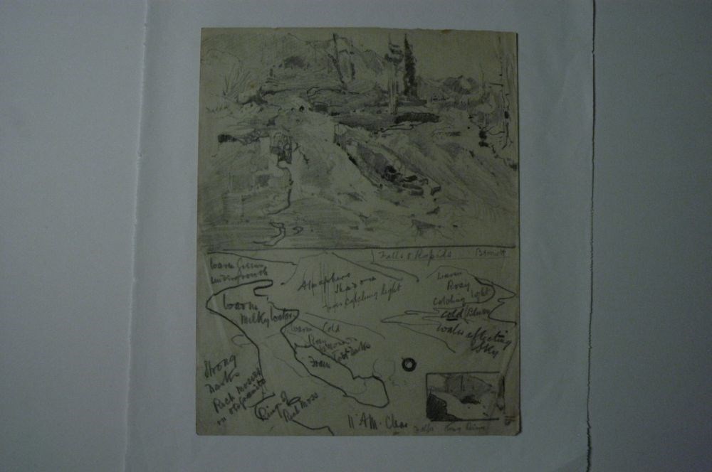
Falls & Rapids
https://archives.whyte.org/en/permalink/artifactcoj.03.325
- Date
- c. 1915
- Medium
- graphite on paper
- Catalogue Number
- CoJ.03.325
- Description
- Paper has been divided into two sections.Top: a scene of waterfalls and rapidsBottom: writing fills the bottom half and dectates colour scheme
1 image
- Title
- Falls & Rapids
- Date
- c. 1915
- Medium
- graphite on paper
- Dimensions
- 26.0 x 20.0 cm
- Description
- Paper has been divided into two sections.Top: a scene of waterfalls and rapidsBottom: writing fills the bottom half and dectates colour scheme
- Credit
- Gift of John Rivette, Seymour Arm, 1997
- Catalogue Number
- CoJ.03.325
Images
This material is presented as originally created; it may contain outdated cultural descriptions and
potentially offensive content.
Read more.
- Date
- c. 1915
- Medium
- graphite on paper
- Catalogue Number
- CoJ.03.326
- Description
- A very small framed drawing is at the top depicting a water scene?A very faint sketch along the middle shows waterfalls with moss. There is writing throughout denoting colours and light and shadow
1 image
- Title
- First Falls
- Date
- c. 1915
- Medium
- graphite on paper
- Dimensions
- 20.0 x 26.0 cm
- Description
- A very small framed drawing is at the top depicting a water scene?A very faint sketch along the middle shows waterfalls with moss. There is writing throughout denoting colours and light and shadow
- Credit
- Gift of John Rivette, Seymour Arm, 1997
- Catalogue Number
- CoJ.03.326
Images

This material is presented as originally created; it may contain outdated cultural descriptions and
potentially offensive content.
Read more.
Geological survey [Okanagan Falls - Similkameen & Osoyoos Dist.]
https://archives.whyte.org/en/permalink/catalogue24737
- Medium
- Library - Book (including soft-cover and pamphlets)
- Map
- Published Date
- 1941
- Publisher
- Dept. of Mines and Resources
- Call Number
- C7-3.5
- Publisher
- Dept. of Mines and Resources
- Published Date
- 1941
- Physical Description
- 1 map : col
- Scale
- Scale: 1 inch to 1 mile
- Relief: Contour interval 100 ft.
- Accession Number
- 673
- Call Number
- C7-3.5
- Collection
- Archives Library
This material is presented as originally created; it may contain outdated cultural descriptions and
potentially offensive content.
Read more.
[Kakwa Falls]
https://archives.whyte.org/en/permalink/catalogue23688
- Medium
- Library - Maps and blueprints (unannotated; published)
- Map
- Published Date
- 1980
- Publisher
- Dept of Energy Mines and Resources
- Edition
- 2
- Call Number
- NTS
- 83L/4
- Edition
- 2
- Publisher
- Dept of Energy Mines and Resources
- Published Date
- 1980
- Physical Description
- Colour
- Scale
- Scale: 1:50,000
- Relief: Contour Interval 100 ft.
- Subjects
- Kakwa Falls
- Notes
- National Topographic System
- Accession Number
- 13,000
- Call Number
- NTS
- 83L/4
- Collection
- Archives Library
This material is presented as originally created; it may contain outdated cultural descriptions and
potentially offensive content.
Read more.
- Date
- c. 1915
- Medium
- graphite on paper
- Catalogue Number
- CoJ.03.323
- Description
- A waterfall scene. Water tumbles over rocks as it makes its way toward the viewer.Writing at top middle “Minor Falls Irrigation Valley above Ashcroft (Sources of Irrigation)”
1 image
- Title
- Minor Falls
- Date
- c. 1915
- Medium
- graphite on paper
- Dimensions
- 26.0 x 20.0 cm
- Description
- A waterfall scene. Water tumbles over rocks as it makes its way toward the viewer.Writing at top middle “Minor Falls Irrigation Valley above Ashcroft (Sources of Irrigation)”
- Credit
- Gift of John Rivette, Seymour Arm, 1997
- Catalogue Number
- CoJ.03.323
Images

This material is presented as originally created; it may contain outdated cultural descriptions and
potentially offensive content.
Read more.
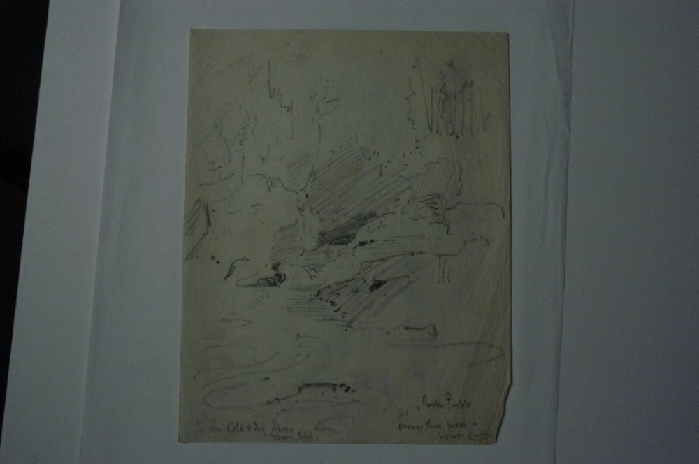
Mountain Stream
https://archives.whyte.org/en/permalink/artifactcoj.03.324
- Date
- c. 1915
- Medium
- graphite on paper
- Catalogue Number
- CoJ.03.324
- Description
- A very rough sketch of a mountain stream through the trees.Some writing in bottom left corner and bottom right corner:blc: “ - - Cold + Icy Sheen [?] foam [?] cold.”brc: “Rocks Purple, orange olive moss in forests [?] - - - “ writing disappears into fold and is indecipherable
1 image
- Title
- Mountain Stream
- Date
- c. 1915
- Medium
- graphite on paper
- Dimensions
- 26.0 x 20.0 cm
- Description
- A very rough sketch of a mountain stream through the trees.Some writing in bottom left corner and bottom right corner:blc: “ - - Cold + Icy Sheen [?] foam [?] cold.”brc: “Rocks Purple, orange olive moss in forests [?] - - - “ writing disappears into fold and is indecipherable
- Credit
- Gift of John Rivette, Seymour Arm, 1997
- Catalogue Number
- CoJ.03.324
Images
This material is presented as originally created; it may contain outdated cultural descriptions and
potentially offensive content.
Read more.
[Ocean Falls - Ootsa Lake 93SW, B.C.]
https://archives.whyte.org/en/permalink/catalogue24193
- Medium
- Library - Maps and blueprints (unannotated; published)
- Map
- Published Date
- 1965
- Publisher
- Dept. of Mines and Technical Surveys
- Call Number
- NTS
- 93SW
- Publisher
- Dept. of Mines and Technical Surveys
- Published Date
- 1965
- Scale
- Scale: 1:500,000
- Altitude tints
- Subjects
- Ocean Falls - Ootsa Lake
- British Columbia
- Notes
- National Topographic System
- Accession Number
- 3000
- Call Number
- NTS
- 93SW
- Collection
- Archives Library
This material is presented as originally created; it may contain outdated cultural descriptions and
potentially offensive content.
Read more.
[Shuswap Falls 82L/7 West - B.C.]
https://archives.whyte.org/en/permalink/catalogue23883
- Medium
- Library - Maps and blueprints (unannotated; published)
- Map
- Published Date
- 1968
- Publisher
- Department of National Defense
- Call Number
- NTS
- 82L/7W
- Publisher
- Department of National Defense
- Published Date
- 1968
- Physical Description
- Colour
- Scale
- Scale: 1:50,000
- Relief: Contour interval 100 ft.
- Subjects
- Shuswap Falls 82L/7 West - B.C.
- Notes
- National Topographic System
- Accession Number
- 7000
- Call Number
- NTS
- 82L/7W
- Collection
- Archives Library
This material is presented as originally created; it may contain outdated cultural descriptions and
potentially offensive content.
Read more.
[Shuswap Falls 82L/7East - B.C.]
https://archives.whyte.org/en/permalink/catalogue23882
- Medium
- Library - Maps and blueprints (unannotated; published)
- Map
- Published Date
- 1968
- Publisher
- Department of National Defense
- Call Number
- NTS
- 82L/7E
- Publisher
- Department of National Defense
- Published Date
- 1968
- Physical Description
- Colour
- Scale
- Scale: 1:50,000
- Relief: Contour interval 100 ft.
- Subjects
- Shuswap Falls 82L/7East - B.C.
- Notes
- National Topographic System
- Accession Number
- 7000
- Call Number
- NTS
- 82L/7E
- Collection
- Archives Library
This material is presented as originally created; it may contain outdated cultural descriptions and
potentially offensive content.
Read more.