Narrow Results By
- Ernest C. W Lamarque (1879 – 1970, Canadian) 2
- James (Sr.) Simpson (1877 – 1972, Canadian) 2
- Peter Whyte (1905 – 1966, Canadian) 2
- Walter Joseph Phillips, R. C. A. (1884 – 1963, Canadian) 2
- Homoky, Stephen G. 1
- Katherine Longstaff Wedgwood 1
- R. H. Mann 1
- Thomas Mower Martin, R. C. A. (1838 – 1934, Canadian) 1
- Chromogenic Colour Print Photograph 49
- Oil Painting 27
- Library - Periodical 23
- Painting 19
- Library - Book (including soft-cover and pamphlets) 13
- Library - Maps and blueprints (unannotated; published)
- Map 13
- Watercolour Painting
- Photograph 7
- Graphite Drawing 4
- Lithograph Print 4
- Chromogenic Colour Print Photograph 3
[Clearwater Forest, Rocky Mountains Forest Reserve]
https://archives.whyte.org/en/permalink/catalogue23243
- Medium
- Library - Maps and blueprints (unannotated; published)
- Map
- Published Date
- 1971
- Publisher
- Dept. of Lands and Forests
- Call Number
- C2-11.4
- Publisher
- Dept. of Lands and Forests
- Published Date
- 1971
- Physical Description
- 1 map : col
- Scale
- Scale: 1" : 3 miles
- Altitude tints
- Accession Number
- 3000
- Call Number
- C2-11.4
- Collection
- Archives Library
This material is presented as originally created; it may contain outdated cultural descriptions and
potentially offensive content.
Read more.
[Bow River Forest Reserve]
https://archives.whyte.org/en/permalink/catalogue23240
- Medium
- Library - Maps and blueprints (unannotated; published)
- Map
- Published Date
- 1965
- Publisher
- Dept. of Lands, Forests
- Call Number
- C2-11.2a
- Publisher
- Dept. of Lands, Forests
- Published Date
- 1965
- Physical Description
- 1 map : col
- Scale
- Scale: 1 inch : 3 miles
- Altitude tints
- Subjects
- Bow River Forest Reserve
- Notes
- C2-11.2b - 1970 reprint - Accn. 3000
- Accession Number
- 718
- Call Number
- C2-11.2a
- Collection
- Archives Library
This material is presented as originally created; it may contain outdated cultural descriptions and
potentially offensive content.
Read more.
Tourist map of the Crowsnest Forest and area/drawn by Stephen T. Homoky
https://archives.whyte.org/en/permalink/catalogue24321
- Medium
- Library - Maps and blueprints (unannotated; published)
- Map
- Published Date
- 1964
- Call Number
- C6-4.3l
- Published Date
- 1964
- Physical Description
- 1 map
- Scale
- 1 inch = 4 miles
- Subjects
- Crowsnest Forest
- Call Number
- C6-4.3l
- Collection
- Archives Library
This material is presented as originally created; it may contain outdated cultural descriptions and
potentially offensive content.
Read more.
Tourist Map of the Crowsnest Forest and Area
https://archives.whyte.org/en/permalink/catalogue23242
- Medium
- Library - Maps and blueprints (unannotated; published)
- Map
- Published Date
- 1964
- Author
- Homoky, Stephen G.
- Publisher
- Robins Printing Co. Ltd., Edmonton
- Call Number
- C2-11.3a
- Author
- Homoky, Stephen G.
- Publisher
- Robins Printing Co. Ltd., Edmonton
- Published Date
- 1964
- Physical Description
- 1 map : col
- Scale
- Scale: 1":5 miles
- Subjects
- Crowsnest Forest
- Accession Number
- 1896
- Call Number
- C2-11.3a
- Collection
- Archives Library
This material is presented as originally created; it may contain outdated cultural descriptions and
potentially offensive content.
Read more.
Tourist map of the Crowsnest Forest and area/drawn by Stephen T. Homoky
https://archives.whyte.org/en/permalink/catalogue23388
- Medium
- Library - Maps and blueprints (unannotated; published)
- Map
- Published Date
- 1964
- Call Number
- C6-4.3l
- Published Date
- 1964
- Physical Description
- 1 map
- Scale
- 1 inch = 4 miles
- Subjects
- Crowsnest Forest
- Call Number
- C6-4.3l
- Collection
- Archives Library
This material is presented as originally created; it may contain outdated cultural descriptions and
potentially offensive content.
Read more.
- Date
- 1964
- Medium
- watercolour on paper
- Catalogue Number
- SiJ.05.58
- Description
- Cloudy night sky, moon is in trc, with mountains in upper left of painting. A valley in the foreground with several trees at the centre of the painting and wooded area at the left of the image. Trees recede into the distance.
- Title
- Untitled
- Date
- 1964
- Medium
- watercolour on paper
- Description
- Cloudy night sky, moon is in trc, with mountains in upper left of painting. A valley in the foreground with several trees at the centre of the painting and wooded area at the left of the image. Trees recede into the distance.
- Subject
- landscape
- Canadian Rockies
- mountain
- forest
- Credit
- Gift of James (Jr.) Simpson, Rocky Mountain House, 2000
- Catalogue Number
- SiJ.05.58
This material is presented as originally created; it may contain outdated cultural descriptions and
potentially offensive content.
Read more.
[Rocky Mountains Forest Reserve]
https://archives.whyte.org/en/permalink/catalogue23239
- Medium
- Library - Maps and blueprints (unannotated; published)
- Map
- Published Date
- 1962
- Publisher
- Alberta Department of Lands and Forests
- Call Number
- C2-11.2
- Publisher
- Alberta Department of Lands and Forests
- Published Date
- 1962
- Scale
- Scale: 1":12 1/2 miles
- Subjects
- Rocky Mountains Forest Reserve
- Notes
- Legend: Picnic and camp facilities
- Accession Number
- 5500
- no accn. number, deaccessioned
- Call Number
- C2-11.2
- Collection
- Archives Library
This material is presented as originally created; it may contain outdated cultural descriptions and
potentially offensive content.
Read more.
[Crowsnest Forest Reserve]
https://archives.whyte.org/en/permalink/catalogue23241
- Medium
- Library - Maps and blueprints (unannotated; published)
- Map
- Published Date
- 1962 (Revised 1968)
- Publisher
- Dept. of Lands and Forests
- Call Number
- C2-11.3
- Publisher
- Dept. of Lands and Forests
- Published Date
- 1962 (Revised 1968)
- Physical Description
- 1 map : col
- Scale
- Scale: 1 inch : 3 miles
- Altitude tints
- Subjects
- Crowsnest Forest Reserve
- Accession Number
- 3000
- Call Number
- C2-11.3
- Collection
- Archives Library
This material is presented as originally created; it may contain outdated cultural descriptions and
potentially offensive content.
Read more.
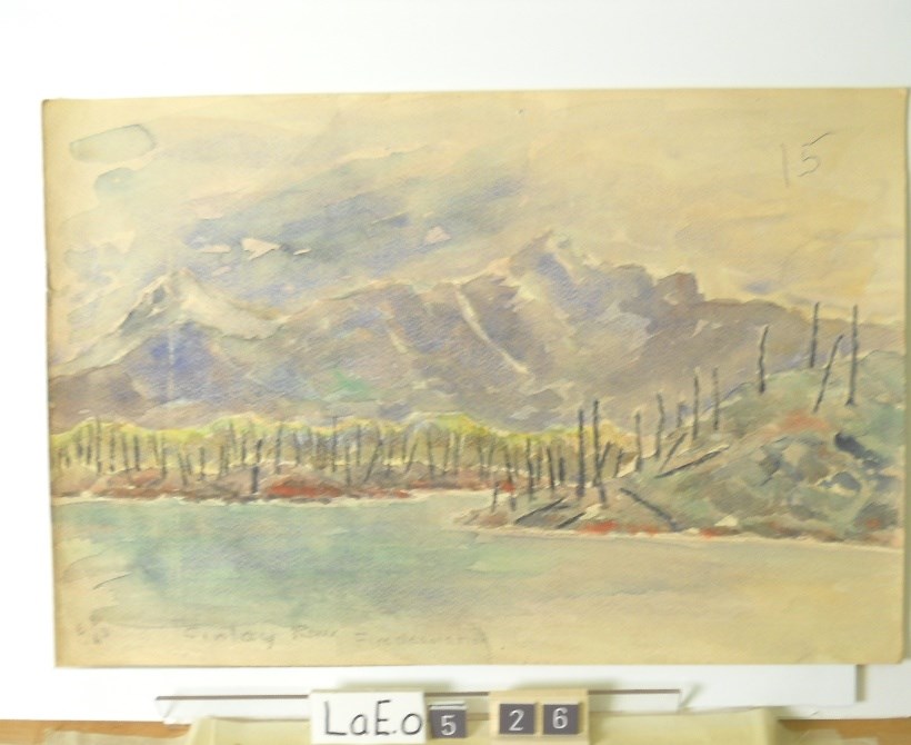
Finlay River, Fire Desolation
https://archives.whyte.org/en/permalink/artifactlae.05.26
- Date
- 1962
- Medium
- watercolour on paper
- Catalogue Number
- LaE.05.26
- Description
- lto mid:” Finlay River, Fire Desolation”
1 image
- Title
- Finlay River, Fire Desolation
- Date
- 1962
- Medium
- watercolour on paper
- Dimensions
- 30.3 x 45.4 cm
- Description
- lto mid:” Finlay River, Fire Desolation”
- Credit
- Gift of Ernest Lamarque (Estate), 1971
- Catalogue Number
- LaE.05.26
Images
This material is presented as originally created; it may contain outdated cultural descriptions and
potentially offensive content.
Read more.
Plan of Control Survey
https://archives.whyte.org/en/permalink/catalogue23244
- Medium
- Library - Maps and blueprints (unannotated; published)
- Map
- Published Date
- May 31, 1961
- Publisher
- Dept. of Highways
- Call Number
- C2-11.5(a)
- Publisher
- Dept. of Highways
- Published Date
- May 31, 1961
- Scale
- Scale: 1:250,000
- Subjects
- Rocky Mountains Forest Reserve Area
- Notes
- Legend in Colour
- Accession Number
- SG7500
- Call Number
- C2-11.5(a)
- Collection
- Archives Library
This material is presented as originally created; it may contain outdated cultural descriptions and
potentially offensive content.
Read more.