Narrow Results By
- Lorraine Gilbert 52
- Douglas Leighton 3
- John Harold Thomas Snow (1911 – 2004, Canadian) 3
- Leighton, Douglas 3
- Engler, Bruno 2
- James (Sr.) Simpson (1877 – 1972, Canadian) 2
- Keith Logan 2
- Alpine Club of Canada 1
- Anderson, Andy 1
- Clarence Ingwall Tillenius (1913 – 2012, Canadian) 1
- Ernest C. W Lamarque (1879 – 1970, Canadian) 1
- Homoky, Stephen G. 1
- Chromogenic Colour Print Photograph 49
- Library - Maps and blueprints (unannotated; published) 7
- Map 7
- Photograph 7
- Chromogenic Colour Print Photograph 3
- Lithograph Print 3
- Transparency 3
- Watercolour Painting 3
- Negative 2
- Film 1
- Graphite Drawing 1
- Library - Book (including soft-cover and pamphlets) 1
Tourist map of the Crowsnest Forest and area/drawn by Stephen T. Homoky
https://archives.whyte.org/en/permalink/catalogue24321
- Medium
- Library - Maps and blueprints (unannotated; published)
- Map
- Published Date
- 1964
- Call Number
- C6-4.3l
- Published Date
- 1964
- Physical Description
- 1 map
- Scale
- 1 inch = 4 miles
- Subjects
- Crowsnest Forest
- Call Number
- C6-4.3l
- Collection
- Archives Library
This material is presented as originally created; it may contain outdated cultural descriptions and
potentially offensive content.
Read more.
[Rocky Mountains Forest Reserve]
https://archives.whyte.org/en/permalink/catalogue23239
- Medium
- Library - Maps and blueprints (unannotated; published)
- Map
- Published Date
- 1962
- Publisher
- Alberta Department of Lands and Forests
- Call Number
- C2-11.2
- Publisher
- Alberta Department of Lands and Forests
- Published Date
- 1962
- Scale
- Scale: 1":12 1/2 miles
- Subjects
- Rocky Mountains Forest Reserve
- Notes
- Legend: Picnic and camp facilities
- Accession Number
- 5500
- no accn. number, deaccessioned
- Call Number
- C2-11.2
- Collection
- Archives Library
This material is presented as originally created; it may contain outdated cultural descriptions and
potentially offensive content.
Read more.
[Bow River Forest Reserve]
https://archives.whyte.org/en/permalink/catalogue23240
- Medium
- Library - Maps and blueprints (unannotated; published)
- Map
- Published Date
- 1965
- Publisher
- Dept. of Lands, Forests
- Call Number
- C2-11.2a
- Publisher
- Dept. of Lands, Forests
- Published Date
- 1965
- Physical Description
- 1 map : col
- Scale
- Scale: 1 inch : 3 miles
- Altitude tints
- Subjects
- Bow River Forest Reserve
- Notes
- C2-11.2b - 1970 reprint - Accn. 3000
- Accession Number
- 718
- Call Number
- C2-11.2a
- Collection
- Archives Library
This material is presented as originally created; it may contain outdated cultural descriptions and
potentially offensive content.
Read more.
[Crowsnest Forest Reserve]
https://archives.whyte.org/en/permalink/catalogue23241
- Medium
- Library - Maps and blueprints (unannotated; published)
- Map
- Published Date
- 1962 (Revised 1968)
- Publisher
- Dept. of Lands and Forests
- Call Number
- C2-11.3
- Publisher
- Dept. of Lands and Forests
- Published Date
- 1962 (Revised 1968)
- Physical Description
- 1 map : col
- Scale
- Scale: 1 inch : 3 miles
- Altitude tints
- Subjects
- Crowsnest Forest Reserve
- Accession Number
- 3000
- Call Number
- C2-11.3
- Collection
- Archives Library
This material is presented as originally created; it may contain outdated cultural descriptions and
potentially offensive content.
Read more.
Tourist Map of the Crowsnest Forest and Area
https://archives.whyte.org/en/permalink/catalogue23242
- Medium
- Library - Maps and blueprints (unannotated; published)
- Map
- Published Date
- 1964
- Author
- Homoky, Stephen G.
- Publisher
- Robins Printing Co. Ltd., Edmonton
- Call Number
- C2-11.3a
- Author
- Homoky, Stephen G.
- Publisher
- Robins Printing Co. Ltd., Edmonton
- Published Date
- 1964
- Physical Description
- 1 map : col
- Scale
- Scale: 1":5 miles
- Subjects
- Crowsnest Forest
- Accession Number
- 1896
- Call Number
- C2-11.3a
- Collection
- Archives Library
This material is presented as originally created; it may contain outdated cultural descriptions and
potentially offensive content.
Read more.
Plan of Control Survey
https://archives.whyte.org/en/permalink/catalogue23244
- Medium
- Library - Maps and blueprints (unannotated; published)
- Map
- Published Date
- May 31, 1961
- Publisher
- Dept. of Highways
- Call Number
- C2-11.5(a)
- Publisher
- Dept. of Highways
- Published Date
- May 31, 1961
- Scale
- Scale: 1:250,000
- Subjects
- Rocky Mountains Forest Reserve Area
- Notes
- Legend in Colour
- Accession Number
- SG7500
- Call Number
- C2-11.5(a)
- Collection
- Archives Library
This material is presented as originally created; it may contain outdated cultural descriptions and
potentially offensive content.
Read more.
Tourist map of the Crowsnest Forest and area/drawn by Stephen T. Homoky
https://archives.whyte.org/en/permalink/catalogue23388
- Medium
- Library - Maps and blueprints (unannotated; published)
- Map
- Published Date
- 1964
- Call Number
- C6-4.3l
- Published Date
- 1964
- Physical Description
- 1 map
- Scale
- 1 inch = 4 miles
- Subjects
- Crowsnest Forest
- Call Number
- C6-4.3l
- Collection
- Archives Library
This material is presented as originally created; it may contain outdated cultural descriptions and
potentially offensive content.
Read more.
Horses to helicopters : stories of the Alberta Forest Service
https://archives.whyte.org/en/permalink/catalogue13651
- Medium
- Library - Book (including soft-cover and pamphlets)
- Published Date
- 1980
- Author
- Huth, Robin
- Publisher
- [Edmonton] :The Service
- Call Number
- 13.124 H97h
- Author
- Huth, Robin
- Publisher
- [Edmonton] :The Service
- Published Date
- 1980
- Physical Description
- 104 p. : ill.
- Accession Number
- 7883
- Call Number
- 13.124 H97h
- Collection
- Archives Library
This material is presented as originally created; it may contain outdated cultural descriptions and
potentially offensive content.
Read more.
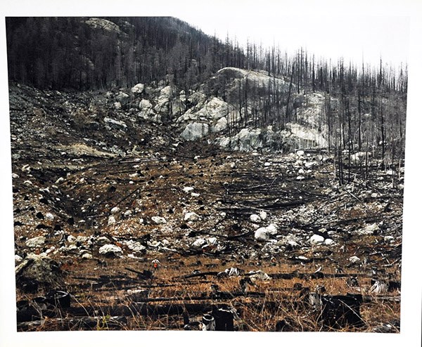
Luc in Bella Coola, B.C.
https://archives.whyte.org/en/permalink/artifactgil.18.01
- Artist
- Lorraine Gilbert
- Date
- 1988 – 1994
- Medium
- photograph on paper
- Catalogue Number
- GiL.18.01
- Description
- Photograph taken in Bella Coola, British Columbia representing the effects of logging on the British Columbian landscape.
1 image
- Artist
- Lorraine Gilbert
- Title
- Luc in Bella Coola, B.C.
- Date
- 1988 – 1994
- Medium
- photograph on paper
- Dimensions
- 20” x 24” cm
- Description
- Photograph taken in Bella Coola, British Columbia representing the effects of logging on the British Columbian landscape.
- Credit
- Gift of Lorraine Gilbert, Ottawa, 2014
- Catalogue Number
- GiL.18.01
Images
This material is presented as originally created; it may contain outdated cultural descriptions and
potentially offensive content.
Read more.
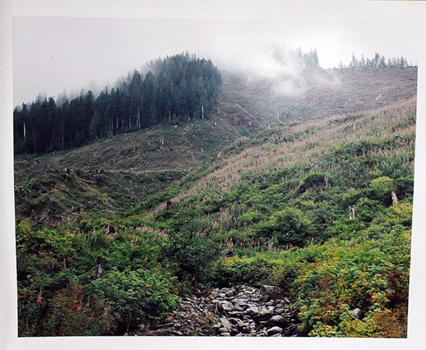
Creekbed, Vancouver Island
https://archives.whyte.org/en/permalink/artifactgil.18.02
- Artist
- Lorraine Gilbert
- Date
- 1988 – 1994
- Medium
- photograph on paper
- Catalogue Number
- GiL.18.02
- Description
- Photograph taken of a creekbed on Vancouver Island. Note: This photograph is the top photograph of a vertical diptych.
1 image
- Artist
- Lorraine Gilbert
- Title
- Creekbed, Vancouver Island
- Date
- 1988 – 1994
- Medium
- photograph on paper
- Dimensions
- 20” x 24” cm
- Description
- Photograph taken of a creekbed on Vancouver Island. Note: This photograph is the top photograph of a vertical diptych.
- Credit
- Gift of Lorraine Gilbert, Ottawa, 2014
- Catalogue Number
- GiL.18.02
Images
This material is presented as originally created; it may contain outdated cultural descriptions and
potentially offensive content.
Read more.