Narrow Results By
- Chromogenic Colour Print Photograph 49
- Oil Painting 27
- Library - Periodical 23
- Painting 19
- Library - Book (including soft-cover and pamphlets) 13
- Library - Maps and blueprints (unannotated; published) 13
- Map
- Watercolour Painting 11
- Photograph
- Graphite Drawing 4
- Lithograph Print 4
- Chromogenic Colour Print Photograph 3
[Alberta-Forest Protection Areas]
https://archives.whyte.org/en/permalink/catalogue23246
- Medium
- Library - Maps and blueprints (unannotated; published)
- Map
- Published Date
- April 1st, 1974
- Publisher
- Surveys Branch, Department of Highways and Transport
- Call Number
- C2-11.6
- Publisher
- Surveys Branch, Department of Highways and Transport
- Published Date
- April 1st, 1974
- Scale
- Scale: 1":50 miles
- Subjects
- Alberta-Forest Protection Areas
- Notes
- Legend in Green
- Accession Number
- SG7500
- Call Number
- C2-11.6
- Collection
- Archives Library
This material is presented as originally created; it may contain outdated cultural descriptions and
potentially offensive content.
Read more.
Athabaska Forest
https://archives.whyte.org/en/permalink/catalogue23248
- Medium
- Library - Maps and blueprints (unannotated; published)
- Map
- Published Date
- 1920 (signed Dec. 1919. Calgary/R.D.M)
- Publisher
- 1920 Forestry Branch
- Call Number
- C2-11.8
- Responsibility
- R.H. Campbell
- Publisher
- 1920 Forestry Branch
- Published Date
- 1920 (signed Dec. 1919. Calgary/R.D.M)
- Scale
- Scale: 3 miles to an inch
- Subjects
- Rocky Mountains Forest Reserve
- Notes
- Prepared under direction of R.H. Campbell Director of Forestry
- Call Number
- C2-11.8
- Collection
- Archives Library
This material is presented as originally created; it may contain outdated cultural descriptions and
potentially offensive content.
Read more.
[Bow River Forest Reserve]
https://archives.whyte.org/en/permalink/catalogue23240
- Medium
- Library - Maps and blueprints (unannotated; published)
- Map
- Published Date
- 1965
- Publisher
- Dept. of Lands, Forests
- Call Number
- C2-11.2a
- Publisher
- Dept. of Lands, Forests
- Published Date
- 1965
- Physical Description
- 1 map : col
- Scale
- Scale: 1 inch : 3 miles
- Altitude tints
- Subjects
- Bow River Forest Reserve
- Notes
- C2-11.2b - 1970 reprint - Accn. 3000
- Accession Number
- 718
- Call Number
- C2-11.2a
- Collection
- Archives Library
This material is presented as originally created; it may contain outdated cultural descriptions and
potentially offensive content.
Read more.
[Clearwater Forest, Rocky Mountains Forest Reserve]
https://archives.whyte.org/en/permalink/catalogue23243
- Medium
- Library - Maps and blueprints (unannotated; published)
- Map
- Published Date
- 1971
- Publisher
- Dept. of Lands and Forests
- Call Number
- C2-11.4
- Publisher
- Dept. of Lands and Forests
- Published Date
- 1971
- Physical Description
- 1 map : col
- Scale
- Scale: 1" : 3 miles
- Altitude tints
- Accession Number
- 3000
- Call Number
- C2-11.4
- Collection
- Archives Library
This material is presented as originally created; it may contain outdated cultural descriptions and
potentially offensive content.
Read more.
[Crowsnest Forest Reserve]
https://archives.whyte.org/en/permalink/catalogue23241
- Medium
- Library - Maps and blueprints (unannotated; published)
- Map
- Published Date
- 1962 (Revised 1968)
- Publisher
- Dept. of Lands and Forests
- Call Number
- C2-11.3
- Publisher
- Dept. of Lands and Forests
- Published Date
- 1962 (Revised 1968)
- Physical Description
- 1 map : col
- Scale
- Scale: 1 inch : 3 miles
- Altitude tints
- Subjects
- Crowsnest Forest Reserve
- Accession Number
- 3000
- Call Number
- C2-11.3
- Collection
- Archives Library
This material is presented as originally created; it may contain outdated cultural descriptions and
potentially offensive content.
Read more.
[Cypress Hills Forest Reserve]
https://archives.whyte.org/en/permalink/catalogue23238
- Medium
- Library - Maps and blueprints (unannotated; published)
- Map
- Published Date
- 1927
- Publisher
- Dept. of The Interior
- Call Number
- C2-11.1
- Publisher
- Dept. of The Interior
- Published Date
- 1927
- Physical Description
- 1 map : col
- Scale
- Scale: 1 inch : 1 mile
- Contour Interval 20 feet
- Subjects
- Cypress Hills Forest Reserve
- Accession Number
- 718
- Call Number
- C2-11.1
- Collection
- Archives Library
This material is presented as originally created; it may contain outdated cultural descriptions and
potentially offensive content.
Read more.
- Part Of
- Douglas Leighton fonds
- Scope & Content
- Files consist of photographs of forest fires burning or trees and area that has been burnt by fires. Includes controlled burns in Banff National Park, Controlled burn on Mt. Norquay, and helicopters and Fire fighters.
- Date Range
- 1981
- 1986
- 1990 - 1993
- 1996
- 1998
- Reference Code
- V222 / III / B / 1 / NS - 1 to 159
- Description Level
- 5 / File
- GMD
- Transparency
- Photograph
- Part Of
- Douglas Leighton fonds
- Description Level
- 5 / File
- Fonds Number
- M133
- V222
- Series
- V222 / III : Trips, Topics or Events
- Sous-Fonds
- V222
- Sub-Series
- V222 / III / B : Forest Fires
- Accession Number
- 2020.24
- Reference Code
- V222 / III / B / 1 / NS - 1 to 159
- Date Range
- 1981
- 1986
- 1990 - 1993
- 1996
- 1998
- Physical Description
- 159 photographs : col. slides ; 35 mm
- Scope & Content
- Files consist of photographs of forest fires burning or trees and area that has been burnt by fires. Includes controlled burns in Banff National Park, Controlled burn on Mt. Norquay, and helicopters and Fire fighters.
- Name Access
- Leighton, Douglas
- Subject Access
- Forest Fires
- Fire preventation
- Geographic Access
- Banff National Park
- Language
- English
- Creator
- Douglas Leighton
- Title Source
- Title based on contents of file
- Processing Status
- Processed
This material is presented as originally created; it may contain outdated cultural descriptions and
potentially offensive content.
Read more.
- Part Of
- Douglas Leighton fonds
- Scope & Content
- Files consist of photographs of forest fires burning or trees and area that has been burnt by fires. Includes controlled burns in Banff National Park, helicopters and firecrew and photos of new growth coming back after a burn.
- Date Range
- 1976
- 1977
- 1980 - 1982
- 1984
- 1986
- 1992
- 1993
- Reference Code
- V222 / III / B / 2 / NS - 1 to 128
- Description Level
- 5 / File
- GMD
- Transparency
- Photograph
- Part Of
- Douglas Leighton fonds
- Description Level
- 5 / File
- Fonds Number
- M133
- V222
- Series
- V222 / III : Trips, Topics or Events
- Sous-Fonds
- V222
- Sub-Series
- V222 / III / B : Forest Fires
- Accession Number
- 2020.24
- Reference Code
- V222 / III / B / 2 / NS - 1 to 128
- Date Range
- 1976
- 1977
- 1980 - 1982
- 1984
- 1986
- 1992
- 1993
- Physical Description
- 128 photographs : col. slides ; 35 mm
- Scope & Content
- Files consist of photographs of forest fires burning or trees and area that has been burnt by fires. Includes controlled burns in Banff National Park, helicopters and firecrew and photos of new growth coming back after a burn.
- Name Access
- Leighton, Douglas
- Subject Access
- Forest Fires
- Fire prevention
- Geographic Access
- Banff National Park
- Alberta
- Language
- English
- Creator
- Douglas Leighton
- Title Source
- Title based on contents of file
- Processing Status
- Processed
This material is presented as originally created; it may contain outdated cultural descriptions and
potentially offensive content.
Read more.
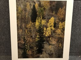
Kicking Horse Pass
https://archives.whyte.org/en/permalink/artifactlgk.18.01
- Artist
- Keith Logan
- Date
- 1982
- Medium
- cibachrome on paper
- Catalogue Number
- LgK.18.01
- Description
- A full frame of trees, coniferous and evergreen, colours mainly browns, oranges, yellows, some green.
1 image
- Artist
- Keith Logan
- Title
- Kicking Horse Pass
- Date
- 1982
- Medium
- cibachrome on paper
- Dimensions
- 50 x 40.0 cm
- Description
- A full frame of trees, coniferous and evergreen, colours mainly browns, oranges, yellows, some green.
- Subject
- landscape, forest
- Credit
- Purchased from Keith Logan, Cochrane, 1984
- Catalogue Number
- LgK.18.01
Images
This material is presented as originally created; it may contain outdated cultural descriptions and
potentially offensive content.
Read more.
Plan of Control Survey
https://archives.whyte.org/en/permalink/catalogue23244
- Medium
- Library - Maps and blueprints (unannotated; published)
- Map
- Published Date
- May 31, 1961
- Publisher
- Dept. of Highways
- Call Number
- C2-11.5(a)
- Publisher
- Dept. of Highways
- Published Date
- May 31, 1961
- Scale
- Scale: 1:250,000
- Subjects
- Rocky Mountains Forest Reserve Area
- Notes
- Legend in Colour
- Accession Number
- SG7500
- Call Number
- C2-11.5(a)
- Collection
- Archives Library
This material is presented as originally created; it may contain outdated cultural descriptions and
potentially offensive content.
Read more.


