Narrow Results By
- Ernest C. W Lamarque (1879 – 1970, Canadian) 2
- James (Sr.) Simpson (1877 – 1972, Canadian) 2
- Peter Whyte (1905 – 1966, Canadian) 2
- Walter Joseph Phillips, R. C. A. (1884 – 1963, Canadian) 2
- Homoky, Stephen G. 1
- Katherine Longstaff Wedgwood 1
- R. H. Mann 1
- Thomas Mower Martin, R. C. A. (1838 – 1934, Canadian) 1
- Chromogenic Colour Print Photograph 49
- Oil Painting 27
- Library - Periodical 23
- Painting 19
- Library - Book (including soft-cover and pamphlets) 13
- Library - Maps and blueprints (unannotated; published)
- Map 13
- Watercolour Painting
- Photograph 7
- Graphite Drawing 4
- Lithograph Print 4
- Chromogenic Colour Print Photograph 3
- Date
- later than 1886
- Medium
- oil on board
- Catalogue Number
- MrT.02.01
- Description
- General colour: green, brown. Central image is a wooden grave marker stuck at the end of a mound of dirt left of center. It reads Sacred to A.R. Underwood. Died July 31, 1886. It is shadowed by a tree whose double trunk is at the right side. Behind is woods, dark trees and light underbrush.
1 image
- Title
- Pioneer Grave
- Date
- later than 1886
- Medium
- oil on board
- Dimensions
- 16.5 x 27.5 cm
- Description
- General colour: green, brown. Central image is a wooden grave marker stuck at the end of a mound of dirt left of center. It reads Sacred to A.R. Underwood. Died July 31, 1886. It is shadowed by a tree whose double trunk is at the right side. Behind is woods, dark trees and light underbrush.
- Subject
- landscape, forest
- historical
- Credit
- Purchased from Bashford's Corner Ltd, Calgary, 1970
- Catalogue Number
- MrT.02.01
Images

This material is presented as originally created; it may contain outdated cultural descriptions and
potentially offensive content.
Read more.
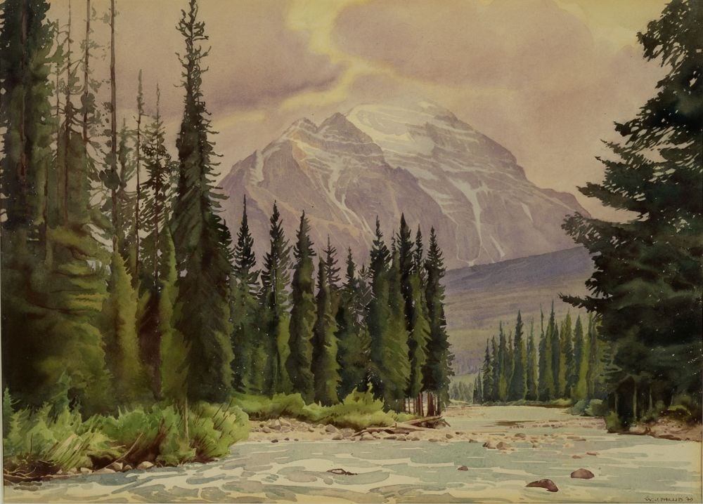
Pipestone Creek Facing Mount Temple
https://archives.whyte.org/en/permalink/artifactphw.05.05
- Date
- 1949
- Medium
- watercolour on paper
- Catalogue Number
- PhW.05.05
- Description
- Colour: green, purple. Across the bottom and up into the right of center area is a river. Rocks sit here and there across it. On each side shrubs and trees grow. In the background to the right side is a purple green hill and in the center behind is a snow capped mountain. The sky is cloudy with a b…
1 image
- Title
- Pipestone Creek Facing Mount Temple
- Date
- 1949
- Medium
- watercolour on paper
- Dimensions
- 39.1 x 55.3 cm
- Description
- Colour: green, purple. Across the bottom and up into the right of center area is a river. Rocks sit here and there across it. On each side shrubs and trees grow. In the background to the right side is a purple green hill and in the center behind is a snow capped mountain. The sky is cloudy with a break upper cnter and in the upper right corner.
- Credit
- Gift of Louise Wilson, Banff, 1969
- Catalogue Number
- PhW.05.05
Images
This material is presented as originally created; it may contain outdated cultural descriptions and
potentially offensive content.
Read more.
Plan of Control Survey
https://archives.whyte.org/en/permalink/catalogue23244
- Medium
- Library - Maps and blueprints (unannotated; published)
- Map
- Published Date
- May 31, 1961
- Publisher
- Dept. of Highways
- Call Number
- C2-11.5(a)
- Publisher
- Dept. of Highways
- Published Date
- May 31, 1961
- Scale
- Scale: 1:250,000
- Subjects
- Rocky Mountains Forest Reserve Area
- Notes
- Legend in Colour
- Accession Number
- SG7500
- Call Number
- C2-11.5(a)
- Collection
- Archives Library
This material is presented as originally created; it may contain outdated cultural descriptions and
potentially offensive content.
Read more.
Plan of S.W. 1/4 Township 26, Range 15, West of the Fifth Meridian showing Yoho Forest Reserve
https://archives.whyte.org/en/permalink/catalogue23247
- Medium
- Library - Maps and blueprints (unannotated; published)
- Map
- Publisher
- Dept. of the Interior
- Call Number
- C2-11.7
- Publisher
- Dept. of the Interior
- Scale
- Scale: 20 chains to the inch
- Series
- Mar. 12, 1917
- Subjects
- Yoho Forest Reserve
- Accession Number
- SG7500
- Call Number
- C2-11.7
- Collection
- Archives Library
This material is presented as originally created; it may contain outdated cultural descriptions and
potentially offensive content.
Read more.
Rocky Mountain Forest Reserve
https://archives.whyte.org/en/permalink/catalogue23249
- Medium
- Library - Maps and blueprints (unannotated; published)
- Map
- Published Date
- 1913-14
- Publisher
- Department of the Interior
- Call Number
- C2-11.9
- Publisher
- Department of the Interior
- Published Date
- 1913-14
- Scale
- Scale: 1".014 = 1 mile
- Accession Number
- 2781
- Call Number
- C2-11.9
- Collection
- Archives Library
This material is presented as originally created; it may contain outdated cultural descriptions and
potentially offensive content.
Read more.
[Rocky Mountains Forest Reserve]
https://archives.whyte.org/en/permalink/catalogue23239
- Medium
- Library - Maps and blueprints (unannotated; published)
- Map
- Published Date
- 1962
- Publisher
- Alberta Department of Lands and Forests
- Call Number
- C2-11.2
- Publisher
- Alberta Department of Lands and Forests
- Published Date
- 1962
- Scale
- Scale: 1":12 1/2 miles
- Subjects
- Rocky Mountains Forest Reserve
- Notes
- Legend: Picnic and camp facilities
- Accession Number
- 5500
- no accn. number, deaccessioned
- Call Number
- C2-11.2
- Collection
- Archives Library
This material is presented as originally created; it may contain outdated cultural descriptions and
potentially offensive content.
Read more.
Tourist Map of the Crowsnest Forest and Area
https://archives.whyte.org/en/permalink/catalogue23242
- Medium
- Library - Maps and blueprints (unannotated; published)
- Map
- Published Date
- 1964
- Author
- Homoky, Stephen G.
- Publisher
- Robins Printing Co. Ltd., Edmonton
- Call Number
- C2-11.3a
- Author
- Homoky, Stephen G.
- Publisher
- Robins Printing Co. Ltd., Edmonton
- Published Date
- 1964
- Physical Description
- 1 map : col
- Scale
- Scale: 1":5 miles
- Subjects
- Crowsnest Forest
- Accession Number
- 1896
- Call Number
- C2-11.3a
- Collection
- Archives Library
This material is presented as originally created; it may contain outdated cultural descriptions and
potentially offensive content.
Read more.
Tourist map of the Crowsnest Forest and area/drawn by Stephen T. Homoky
https://archives.whyte.org/en/permalink/catalogue24321
- Medium
- Library - Maps and blueprints (unannotated; published)
- Map
- Published Date
- 1964
- Call Number
- C6-4.3l
- Published Date
- 1964
- Physical Description
- 1 map
- Scale
- 1 inch = 4 miles
- Subjects
- Crowsnest Forest
- Call Number
- C6-4.3l
- Collection
- Archives Library
This material is presented as originally created; it may contain outdated cultural descriptions and
potentially offensive content.
Read more.
Tourist map of the Crowsnest Forest and area/drawn by Stephen T. Homoky
https://archives.whyte.org/en/permalink/catalogue23388
- Medium
- Library - Maps and blueprints (unannotated; published)
- Map
- Published Date
- 1964
- Call Number
- C6-4.3l
- Published Date
- 1964
- Physical Description
- 1 map
- Scale
- 1 inch = 4 miles
- Subjects
- Crowsnest Forest
- Call Number
- C6-4.3l
- Collection
- Archives Library
This material is presented as originally created; it may contain outdated cultural descriptions and
potentially offensive content.
Read more.
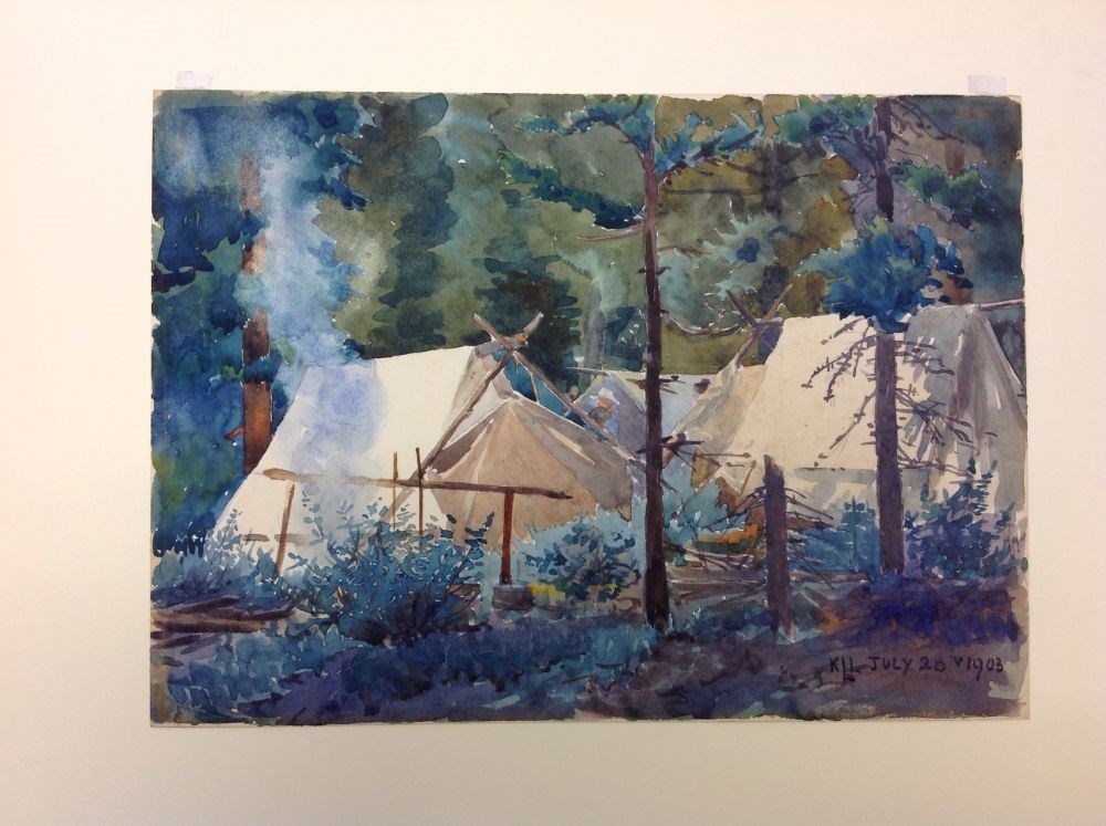
- Artist
- Katherine Longstaff Wedgwood
- Date
- 1903
- Medium
- watercolour on paper
- Catalogue Number
- WeK.05.01
- Description
- Camping scene of tents in forested area at 40 Mile Creek near Cascade Mountain. Smoke from fire on left of image.
1 image
- Artist
- Katherine Longstaff Wedgwood
- Title
- Untitled
- Date
- 1903
- Medium
- watercolour on paper
- Dimensions
- 22 x 30.4 cm
- Description
- Camping scene of tents in forested area at 40 Mile Creek near Cascade Mountain. Smoke from fire on left of image.
- Credit
- Gift of Bobby Hunter, 1973
- Catalogue Number
- WeK.05.01
Images
This material is presented as originally created; it may contain outdated cultural descriptions and
potentially offensive content.
Read more.