Narrow Results By
Surficial Geology of the Banff Area to accompany G.S.C. Bulletin # 206 by N.W. Rutter
https://archives.whyte.org/en/permalink/catalogue24698
- Medium
- Library - Book (including soft-cover and pamphlets)
- Map
- Published Date
- 1972
- Publisher
- G.S.C. Dept. of Energy, Mines and Resources
- Call Number
- C7-1.10(e)
- Publisher
- G.S.C. Dept. of Energy, Mines and Resources
- Published Date
- 1972
- Scale
- Scale: 1:50,000
- Subjects
- Banff Geology
- Accession Number
- 5500
- Call Number
- C7-1.10(e)
- Collection
- Archives Library
This material is presented as originally created; it may contain outdated cultural descriptions and
potentially offensive content.
Read more.
Geological Map. Relative ages of surficial deposits in the Banff area
https://archives.whyte.org/en/permalink/catalogue24699
- Medium
- Library - Book (including soft-cover and pamphlets)
- Map
- Published Date
- 1972
- Publisher
- G.S.C. Dept. of Energy, Mines and Resources
- Call Number
- C7-1.10(f)
- Publisher
- G.S.C. Dept. of Energy, Mines and Resources
- Published Date
- 1972
- Scale
- Scale: 1:125,000
- Subjects
- Banff Geology
- Accession Number
- 5500
- Call Number
- C7-1.10(f)
- Collection
- Archives Library
This material is presented as originally created; it may contain outdated cultural descriptions and
potentially offensive content.
Read more.
Lucerne: West half, British Columbia (83D15)
https://archives.whyte.org/en/permalink/catalogue24708
- Medium
- Library - Book (including soft-cover and pamphlets)
- Map
- Published Date
- 1990
- Publisher
- Calgary : Geological Survey of Canada
- Call Number
- C7-1.20
- Responsibility
- M.R. McDonough and E.W. Mountjoy
- Publisher
- Calgary : Geological Survey of Canada
- Published Date
- 1990
- Physical Description
- 1 map -- (Open file report 2260)
- Scale
- 1:50,000
- Accession Number
- 23,000
- Call Number
- C7-1.20
- Collection
- Archives Library
This material is presented as originally created; it may contain outdated cultural descriptions and
potentially offensive content.
Read more.
Geology of Rocky Mountain Foothills and Front Ranges in Kananaskis Country ...
https://archives.whyte.org/en/permalink/catalogue24709
- Medium
- Library - Book (including soft-cover and pamphlets)
- Map
- Published Date
- 1993
- Publisher
- Calgary : Geological Survey of Canada
- Call Number
- C7-1.21
- Publisher
- Calgary : Geological Survey of Canada
- Published Date
- 1993
- Physical Description
- 1 map. -- (Open file report 2642)
- Scale
- 1:100,000
- Accession Number
- 26,000
- Call Number
- C7-1.21
- Collection
- Archives Library
This material is presented as originally created; it may contain outdated cultural descriptions and
potentially offensive content.
Read more.
Geology : Clemenceau Icefield (west half), British Columbia
https://archives.whyte.org/en/permalink/catalogue24710
- Medium
- Library - Book (including soft-cover and pamphlets)
- Map
- Published Date
- 1993
- Publisher
- Ottawa : Geological Survey of Canada
- Edition
- 2nd ed.
- Call Number
- C7-1.22
- Edition
- 2nd ed.
- Publisher
- Ottawa : Geological Survey of Canada
- Published Date
- 1993
- Physical Description
- 1 map. -- (Open file report 2608)
- Scale
- 1:50,000
- Accession Number
- 26,000
- Call Number
- C7-1.22
- Collection
- Archives Library
This material is presented as originally created; it may contain outdated cultural descriptions and
potentially offensive content.
Read more.
Kananaskis Lakes (NTS 82J)
https://archives.whyte.org/en/permalink/catalogue24715
- Medium
- Library - Book (including soft-cover and pamphlets)
- Map
- Published Date
- 1979?
- Publisher
- Ottawa : Geological Survey of Canada
- Call Number
- C7-1.27
- Publisher
- Ottawa : Geological Survey of Canada
- Published Date
- 1979?
- Physical Description
- 1 map
- Scale
- 1:126,720
- Notes
- (Open file ; no.634)
- In Oversize Cabinet (rolled up)
- Accession Number
- 12,000
- Call Number
- C7-1.27
- Collection
- Archives Library
This material is presented as originally created; it may contain outdated cultural descriptions and
potentially offensive content.
Read more.
Geology photos for geological views
https://archives.whyte.org/en/permalink/descriptions55990
- Part Of
- Ben Gadd fonds
- Scope & Content
- File consists of printed photographs compiled by Ben Gadd pertaining to his book, Handbook of the Canadian Rockies. Images depict mountain views; bighorn sheep posing on steep rock; and highway views, possibly including Icefields Parkway.
- Date Range
- [ca.1990-1995]
- Reference Code
- V810 / II / A / PA - 40 to 138
- Description Level
- 5 / File
- GMD
- Photograph
- Part Of
- Ben Gadd fonds
- Description Level
- 5 / File
- Fonds Number
- M590
- V810
- S61
- Series
- V810 / II : Research and publication records
- Sous-Fonds
- V810
- Sub-Series
- V810 / II / B : Handbook of the Canadian Rockies
- Accession Number
- 2021.20
- Reference Code
- V810 / II / A / PA - 40 to 138
- GMD
- Photograph
- Responsibility
- Produced by Ben Gadd
- Date Range
- [ca.1990-1995]
- Physical Description
- 99 photographs : col. prints ; 15 x 10 cm
- Scope & Content
- File consists of printed photographs compiled by Ben Gadd pertaining to his book, Handbook of the Canadian Rockies. Images depict mountain views; bighorn sheep posing on steep rock; and highway views, possibly including Icefields Parkway.
- Material Details
- Photographs were originally stored in Tekarra Color Lab envelope
- Subject Access
- Publication
- Landscapes
- Travel
- Roads
- Wildlife
- Bighorn Sheep
- Mountains
- Geology
- Environment
- Natural history
- Geographic Access
- Canada
- Alberta
- Columbia Icefield
- Jasper National Park
- Canadian Rocky Mountains
- Reproduction Restrictions
- Restrictions may apply
- Language
- English
- Title Source
- Original title used
- Processing Status
- Processed
This material is presented as originally created; it may contain outdated cultural descriptions and
potentially offensive content.
Read more.
Geology and cross section : Mountain Park, Alberta
https://archives.whyte.org/en/permalink/catalogue24731
- Medium
- Library - Book (including soft-cover and pamphlets)
- Map
- Published Date
- 1992
- Publisher
- Ottawa: Calgary: Geological Survey of Canada
- Call Number
- C7-2.15
- Responsibility
- E.W. Mountjoy et al.
- Publisher
- Ottawa: Calgary: Geological Survey of Canada
- Published Date
- 1992
- Physical Description
- 2 maps on 1 sheet : col
- Scale
- Scale: 1:50,000
- Notes
- Map 1830A
- Accession Number
- 26,000
- Call Number
- C7-2.15
- Collection
- Archives Library
This material is presented as originally created; it may contain outdated cultural descriptions and
potentially offensive content.
Read more.
Geology : Waterton Lakes, Alberta
https://archives.whyte.org/en/permalink/catalogue24732
- Medium
- Library - Book (including soft-cover and pamphlets)
- Map
- Published Date
- 1994
- Publisher
- Calgary : Geological Survey of Canada
- Call Number
- C7-2.16
- Publisher
- Calgary : Geological Survey of Canada
- Published Date
- 1994
- Physical Description
- 1 map : col
- Scale
- Scale: 1:50,000
- Notes
- Open file / Geological Survey of Canada ; 2855
- Recommended citation: Lebel, D., Douglas, R.J.W. and Norris, D.K. 1994. Waterton Lakes (82H/4), Alberta - Geology (preliminary) ... Southern Alberta Natmap project
- Accession Number
- 27,500
- Call Number
- C7-2.16
- Collection
- Archives Library
This material is presented as originally created; it may contain outdated cultural descriptions and
potentially offensive content.
Read more.
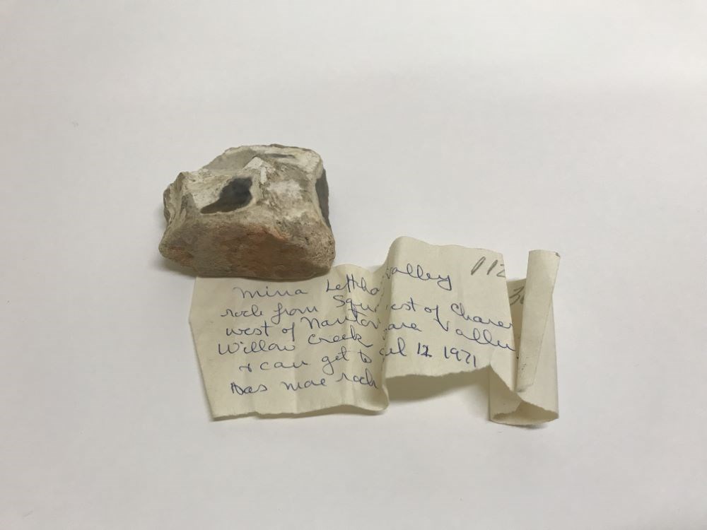
- Date
- 1971
- Material
- stone
- Catalogue Number
- 112.03.3001
- Description
- Rectangular white stone with dark green, blue and white inclusion. Accompanied by a piece of paper with CRW writing: “Mina Lefthand rock from Squaw Valley west of Nanton - willow creek is weat of Clairesholm & can get to Squaw Valley that way. Has more rock. April 12 1971.”
1 image
- Title
- Rock
- Date
- 1971
- Material
- stone
- Dimensions
- 4.0 x 6.0 x 7.5 cm
- Description
- Rectangular white stone with dark green, blue and white inclusion. Accompanied by a piece of paper with CRW writing: “Mina Lefthand rock from Squaw Valley west of Nanton - willow creek is weat of Clairesholm & can get to Squaw Valley that way. Has more rock. April 12 1971.”
- Credit
- Gift of Catharine Robb Whyte, O. C., Banff, 1979
- Catalogue Number
- 112.03.3001
Images
This material is presented as originally created; it may contain outdated cultural descriptions and
potentially offensive content.
Read more.