Narrow Results By
- Peter Whyte (1905 – 1966, Canadian) 10
- Janet Holly Middleton (1922 – 2018, Canadian) 5
- Aldro T. Hibbard (1886 – 1972, American) 2
- Catharine Robb Whyte, O. C. (1906 – 1979, Canadian) 1
- Charles John Collings (1848 – 1931, British) 1
- John Davenall Turner (1900 – 1980, Canadian) 1
- Laurier Hunter 1
- Robert J. Hope (1948 – 2023, Canadian) 1
[Wildcat Hills 82 0/7 East - Alberta]
https://archives.whyte.org/en/permalink/catalogue23952
- Medium
- Library - Maps and blueprints (unannotated; published)
- Map
- Published Date
- 1961
- Publisher
- Dept. Of Mines and Technical Surveys
- Call Number
- NTS
- 820/7E
- Publisher
- Dept. Of Mines and Technical Surveys
- Published Date
- 1961
- Physical Description
- Black and White
- Scale
- Scale: 1:50,000
- Relief: Contour interval 25'
- Subjects
- Wildcat Hills 82 0/7 East - Alberta
- Notes
- National Topographic System
- Call Number
- NTS
- 820/7E
- Collection
- Archives Library
This material is presented as originally created; it may contain outdated cultural descriptions and
potentially offensive content.
Read more.
[Wildcat Hills 82 0/7 West - Alberta]
https://archives.whyte.org/en/permalink/catalogue23953
- Medium
- Library - Maps and blueprints (unannotated; published)
- Map
- Published Date
- 1960
- Publisher
- Dept. of Mines and Technical Surveys
- Call Number
- NTS
- 820/7W
- Publisher
- Dept. of Mines and Technical Surveys
- Published Date
- 1960
- Physical Description
- Colour
- Scale
- Scale: 1:50,000
- Relief: Contour interval 100'
- Subjects
- Wildcat Hills 82 0/7 West - Alberta
- Notes
- National Topographic System
- Call Number
- NTS
- 820/7W
- Collection
- Archives Library
This material is presented as originally created; it may contain outdated cultural descriptions and
potentially offensive content.
Read more.
Geological map of the Wildcat Hills area. West Half
https://archives.whyte.org/en/permalink/catalogue24724
- Medium
- Library - Book (including soft-cover and pamphlets)
- Map
- Published Date
- 1972
- Publisher
- Geological Survey of Canada
- Call Number
- C7-2.10
- Publisher
- Geological Survey of Canada
- Published Date
- 1972
- Scale
- Scale: 1:50,000
- Series
- Map 1351A
- Subjects
- Alberta, Wildcat Hills
- Accession Number
- 11000
- Call Number
- C7-2.10
- Collection
- Archives Library
This material is presented as originally created; it may contain outdated cultural descriptions and
potentially offensive content.
Read more.
Geological maps
https://archives.whyte.org/en/permalink/catalogue24792
- Medium
- Library - Book (including soft-cover and pamphlets)
- Map
- Published Date
- 1885
- Publisher
- Geological and Natural History Survey of Canada
- Call Number
- C7-6.19
- Publisher
- Geological and Natural History Survey of Canada
- Published Date
- 1885
- Scale
- 1:506,880
- Notes
- (a) Geological and Topographical
- (b) Surface Character
- Accession Number
- 400
- Call Number
- C7-6.19
- Collection
- Archives Library
This material is presented as originally created; it may contain outdated cultural descriptions and
potentially offensive content.
Read more.
[Alberta, Wildcat Hills]
https://archives.whyte.org/en/permalink/catalogue21463
- Medium
- Library - Book (including soft-cover and pamphlets)
- Map
- Published Date
- 1972
- Publisher
- Geological Survey of Canada
- Call Number
- C7-2.10(a)
- Publisher
- Geological Survey of Canada
- Published Date
- 1972
- Series
- Map 1351A
- Subjects
- Alberta, Wildcat Hills
- Notes
- Diagrammatic structure to accompany C7-2.10 (Map 1351A) map of the Wildcat Hills, geological
- Accession Number
- 11000
- Call Number
- C7-2.10(a)
- Collection
- Archives Library
This material is presented as originally created; it may contain outdated cultural descriptions and
potentially offensive content.
Read more.
[Cypress Hills Forest Reserve]
https://archives.whyte.org/en/permalink/catalogue23238
- Medium
- Library - Maps and blueprints (unannotated; published)
- Map
- Published Date
- 1927
- Publisher
- Dept. of The Interior
- Call Number
- C2-11.1
- Publisher
- Dept. of The Interior
- Published Date
- 1927
- Physical Description
- 1 map : col
- Scale
- Scale: 1 inch : 1 mile
- Contour Interval 20 feet
- Subjects
- Cypress Hills Forest Reserve
- Accession Number
- 718
- Call Number
- C2-11.1
- Collection
- Archives Library
This material is presented as originally created; it may contain outdated cultural descriptions and
potentially offensive content.
Read more.
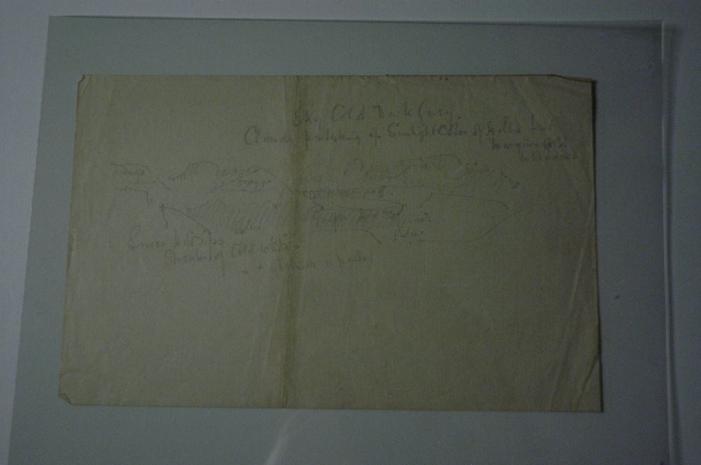
Rough Hillscape
https://archives.whyte.org/en/permalink/artifactcoj.03.530
- Date
- c. 1920
- Medium
- graphite on paper
- Catalogue Number
- CoJ.03.530
- Description
- A faint and rough sketch of hills and valley appears in middle of page. Above and below this sketch, there is writing that denotes colour scheme and details.
1 image
- Title
- Rough Hillscape
- Date
- c. 1920
- Medium
- graphite on paper
- Dimensions
- 16.5 x 25.0 cm
- Description
- A faint and rough sketch of hills and valley appears in middle of page. Above and below this sketch, there is writing that denotes colour scheme and details.
- Credit
- Gift of John Rivette, Seymour Arm, 1997
- Catalogue Number
- CoJ.03.530
Images
This material is presented as originally created; it may contain outdated cultural descriptions and
potentially offensive content.
Read more.
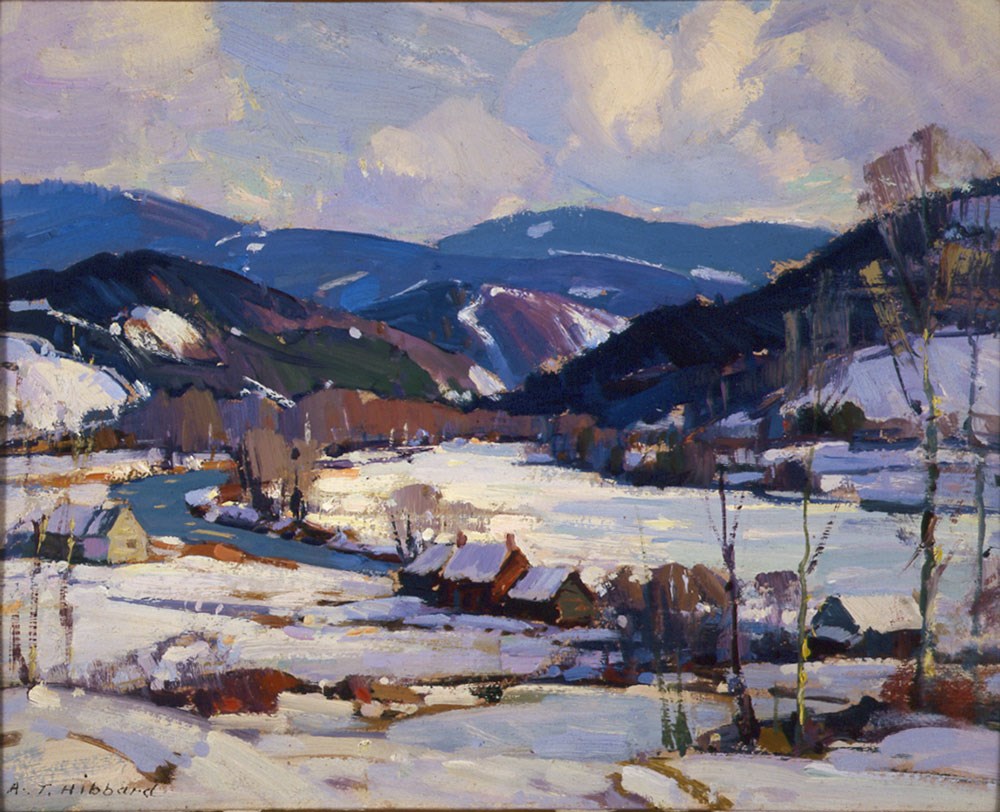
Landscape in Vermont
https://archives.whyte.org/en/permalink/artifacthba.01.01
- Date
- n.d.
- Medium
- oil on board
- Catalogue Number
- HbA.01.01
- Description
- Snow landscape with houses, river and distant mountains; signed blc A.T. Hibbard; penciled on board Landscape in Vermont - Hibbard.
1 image
- Title
- Landscape in Vermont
- Date
- n.d.
- Medium
- oil on board
- Dimensions
- 19.5 x 24.3 cm
- Description
- Snow landscape with houses, river and distant mountains; signed blc A.T. Hibbard; penciled on board Landscape in Vermont - Hibbard.
- Credit
- Gift of Catharine Robb Whyte, O. C., Banff, 1979
- Catalogue Number
- HbA.01.01
Images
This material is presented as originally created; it may contain outdated cultural descriptions and
potentially offensive content.
Read more.
Covered Bridge
https://archives.whyte.org/en/permalink/artifacthba.04.02
- Date
- 1938
- Medium
- woodcut on paper
- Catalogue Number
- HbA.04.02
1 image
- Title
- Covered Bridge
- Date
- 1938
- Medium
- woodcut on paper
- Dimensions
- 12.3 x 17.4 cm
- Credit
- Gift of Catharine Robb Whyte, O. C., Banff, 1979
- Catalogue Number
- HbA.04.02
Images

This material is presented as originally created; it may contain outdated cultural descriptions and
potentially offensive content.
Read more.
Drawing from Timberline Tales
https://archives.whyte.org/en/permalink/artifacthor.03.01
- Date
- 1975
- Medium
- ink; watercolour on paper
- Catalogue Number
- HoR.03.01
- Description
- General colour: black, gold on white. Two frames within a third. Top frame is empty. However frame has all four corners slightly separated from the main. In the foreground there are rocks and a little trail. In the middleground are a group of trees and two dark rocks. In the background is the outli…
- Title
- Drawing from Timberline Tales
- Date
- 1975
- Medium
- ink; watercolour on paper
- Dimensions
- 12.7 x 16.5 cm
- Description
- General colour: black, gold on white. Two frames within a third. Top frame is empty. However frame has all four corners slightly separated from the main. In the foreground there are rocks and a little trail. In the middleground are a group of trees and two dark rocks. In the background is the outline of mountains.
- Subject
- landscape, hills
- Credit
- Purchased from Robert J. Hope, 1975
- Catalogue Number
- HoR.03.01
This material is presented as originally created; it may contain outdated cultural descriptions and
potentially offensive content.
Read more.