Narrow Results By
Showing part of the Summit Range of the Canadian Rocky Mountains
https://archives.whyte.org/en/permalink/catalogue24615
- Medium
- Library - Maps and blueprints (unannotated; published)
- Map
- Published Date
- 1900
- Author
- Wilcox, Walter D.
- Call Number
- C3-2.1a
- Author
- Wilcox, Walter D.
- Responsibility
- Surveyed and drawn by Walter D. Wilcox
- Published Date
- 1900
- Physical Description
- Colour
- Scale
- Scale: 1 1/2 inch = 1 mile
- Relief: Contour interval 100'
- Subjects
- Lake Louise
- Notes
- Photostatic copy
- Accession Number
- 400
- 675
- Call Number
- C3-2.1a
- Collection
- Archives Library
This material is presented as originally created; it may contain outdated cultural descriptions and
potentially offensive content.
Read more.
Maps of exploration survey of divide between Great Slave Lake and Hudson Bay
https://archives.whyte.org/en/permalink/catalogue21400
- Medium
- Library - Maps and blueprints (unannotated; published)
- Map
- Published Date
- 1900
- Publisher
- Districts of MacKenzie and Keewatin, Dominion of Canada
- Call Number
- C8-3.3(a-v)
- Publisher
- Districts of MacKenzie and Keewatin, Dominion of Canada
- Published Date
- 1900
- Notes
- See: Sheets 1-22 (no. 11 missing)
- Accession Number
- 1248
- Call Number
- C8-3.3(a-v)
- Collection
- Archives Library
This material is presented as originally created; it may contain outdated cultural descriptions and
potentially offensive content.
Read more.
Banff in the Canadian Rockies and the glaciers of the Selkirks
https://archives.whyte.org/en/permalink/catalogue15311
- Medium
- Library - Book (including soft-cover and pamphlets)
- Published Date
- 1900
- Call Number
- 08.3 B22c Pam
- Responsibility
- Canadian Pacific Railway
- Published Date
- 1900
- Subjects
- Banff
- Banff Springs Hotel
- Bow Valley
- Field
- Fraser River
- Hot springs
- Lake Louise
- Minnewanka, Lake
- Revelstoke
- Vancouver, British Columbia
- Vermilion Lakes
- Accession Number
- 2014.8385
- Call Number
- 08.3 B22c Pam
- Collection
- Archives Library
This material is presented as originally created; it may contain outdated cultural descriptions and
potentially offensive content.
Read more.
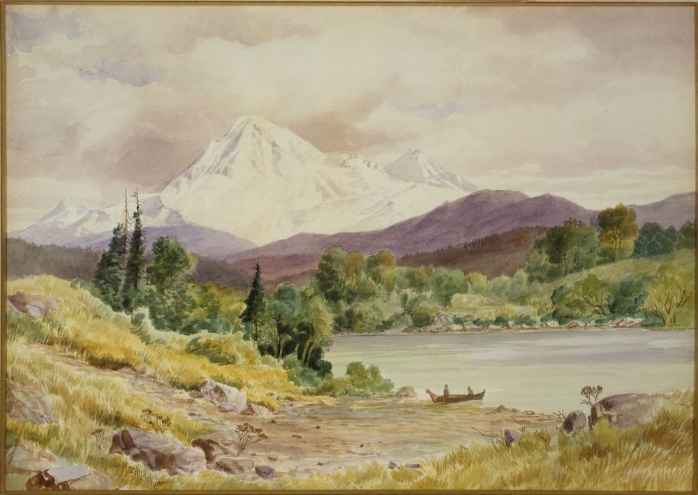
Mount Baker from B.C. Coast, Olympic Range, Siwash Indian Boat
https://archives.whyte.org/en/permalink/artifactmrt.05.01
- Date
- 1900
- Medium
- watercolour on paper
- Catalogue Number
- MrT.05.01
- Description
- Foreground has yellow grasses, rocks and a bare ground leading towards light blue water to the right of the picture. On the edge of the water on the bare embankment is a canoe with two people. Green trees to left centre of foreground and across the river, low blue/purple mountains are in front of s…
1 image
- Title
- Mount Baker from B.C. Coast, Olympic Range, Siwash Indian Boat
- Date
- 1900
- Medium
- watercolour on paper
- Dimensions
- 46.5 x 66.0 cm
- Description
- Foreground has yellow grasses, rocks and a bare ground leading towards light blue water to the right of the picture. On the edge of the water on the bare embankment is a canoe with two people. Green trees to left centre of foreground and across the river, low blue/purple mountains are in front of snow-capped mountains to centre left. Cloudy sky with a few patches of blue.
- Subject
- landscape
- mountain
- lake
- figure, male
- Credit
- Purchased from Sotheby Parke Bernet (Canada) Ltd, Toronto, 1984
- Catalogue Number
- MrT.05.01
Images
This material is presented as originally created; it may contain outdated cultural descriptions and
potentially offensive content.
Read more.
Topographical map
https://archives.whyte.org/en/permalink/catalogue24617
- Medium
- Library - Maps and blueprints (unannotated; published)
- Map
- Published Date
- 1902
- Publisher
- Dept. of the Interior
- Call Number
- C3-2.2
- Publisher
- Dept. of the Interior
- Published Date
- 1902
- Physical Description
- Colour
- Scale
- Scale: 2 miles to 1 inch
- Relief: Contour interval 250'
- Subjects
- Lake Louise
- Notes
- Duplicates (7) in Map Room
- Accession Number
- 400
- Call Number
- C3-2.2
- Collection
- Archives Library
This material is presented as originally created; it may contain outdated cultural descriptions and
potentially offensive content.
Read more.
Climbing English crags
https://archives.whyte.org/en/permalink/catalogue372
- Medium
- Library - Book (including soft-cover and pamphlets)
- Published Date
- 1904
- Author
- Benson, Claude E
- Call Number
- DA670 L1 B45 Pam
- Author
- Benson, Claude E
- Published Date
- 1904
- Subjects
- Lake District
- Notes
- Fry's magazine
- Call Number
- DA670 L1 B45 Pam
- Collection
- Alpine Club of Canada Library
This material is presented as originally created; it may contain outdated cultural descriptions and
potentially offensive content.
Read more.
[Lake Louise, Moraine Lake and Vermilion Pass]
https://archives.whyte.org/en/permalink/catalogue24616
- Medium
- Library - Maps and blueprints (unannotated; published)
- Map
- Published Date
- 1905
- Publisher
- Dept. of the Interior
- Call Number
- C3-2.1(b)
- Publisher
- Dept. of the Interior
- Published Date
- 1905
- Physical Description
- Colour
- Scale
- Scale: 1:60,000
- Relief: Contour interval 500 ft.
- Accession Number
- 400
- Call Number
- C3-2.1(b)
- Collection
- Archives Library
This material is presented as originally created; it may contain outdated cultural descriptions and
potentially offensive content.
Read more.
Sketch map showing the vicinity of Lake Louise, Moraine Lake and Vermilion Pass
https://archives.whyte.org/en/permalink/catalogue21355
- Medium
- Library - Maps and blueprints (unannotated; published)
- Map
- Published Date
- 1905
- Publisher
- Department of the Interior
- Call Number
- C6-4.3(i)
- Publisher
- Department of the Interior
- Published Date
- 1905
- Subjects
- Lake Louise - Roads & Trails
- Notes
- Driving Roads, Pony trails
- From photographic surveys by A.O. Wheeler, Topographer of the Department assisted by M.P. Bridgland D.L.S. and H.G. Wheeler
- Accession Number
- 3120
- Call Number
- C6-4.3(i)
- Collection
- Archives Library
This material is presented as originally created; it may contain outdated cultural descriptions and
potentially offensive content.
Read more.
Sketch map showing the vicinity of Lake Louise, Moraine Lake and Vermilion Pass
https://archives.whyte.org/en/permalink/catalogue21385
- Medium
- Library - Maps and blueprints (unannotated; published)
- Map
- Published Date
- 1905
- Publisher
- Department of the Interior
- Call Number
- C6-4.3(i)
- Publisher
- Department of the Interior
- Published Date
- 1905
- Subjects
- Lake Louise - Roads & Trails
- Notes
- Driving Roads, Pony trails
- From photographic surveys by A.O. Wheeler, Topographer of the Department assisted by M.P. Bridgland D.L.S. and H.G. Wheeler
- Accession Number
- 3120
- Call Number
- C6-4.3(i)
- Collection
- Archives Library
This material is presented as originally created; it may contain outdated cultural descriptions and
potentially offensive content.
Read more.
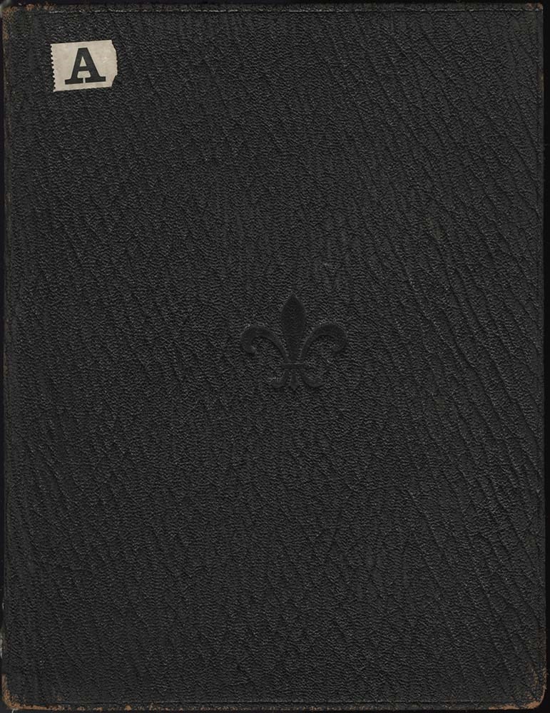
Canadian Mountains Album
https://archives.whyte.org/en/permalink/descriptions57659
- Part Of
- Alpine Club of Canada fonds
- Scope & Content
- Item consists of 1 photograph album compiled by Frank W. Freeborn of New York City for the Alpine Club of Canada. The album pertains to a 1905 ACC trip in and around the Banff & Lake Louise areas and includes black and white photographs and colourized postcards, all of which are annotated in white …
- Date Range
- 1905
- Reference Code
- V14 / AC 55P / PD - 1
- Description Level
- 6 / Item
- GMD
- Album
- Photograph
1 image
1 Electronic Resource
- Part Of
- Alpine Club of Canada fonds
- Description Level
- 6 / Item
- Fonds Number
- M200 / S6 / V14
- Series
- IV.B. Other material: photographic
- Sous-Fonds
- V14
- Accession Number
- 5200
- Reference Code
- V14 / AC 55P / PD - 1
- GMD
- Album
- Photograph
- Date Range
- 1905
- Physical Description
- 1 album (112 photographs : b&w and col. ; 25.7 x 20.3 cm)
- Scope & Content
- Item consists of 1 photograph album compiled by Frank W. Freeborn of New York City for the Alpine Club of Canada. The album pertains to a 1905 ACC trip in and around the Banff & Lake Louise areas and includes black and white photographs and colourized postcards, all of which are annotated in white ink. A fleur-de-lis is stamped into the center of the front cover, a small adhesive paper with an "A" printed on it is adhered to the top left corner, and "1905" is written in white ink on the spine.
- Name Access
- Alpine Club of Canada
- Subject Access
- Activities
- Alpine Club of Canada
- Animals
- Backpacking
- Banff townsite
- Bow Falls
- Bow River
- Bow Valley
- Buildings
- Camps
- Chateau Lake Louise
- Climbing
- Clothing and dress
- Club
- Environment and Nature
- Glaciers
- Hiking
- Horses
- Hotels
- Lake Louise
- Landscapes
- Mountaineering
- Mountaineers
- Mountains
- Period costume
- Photography
- Portrait
- Railways
- Scenery
- scenic
- Trails
- Transportation
- Geographic Access
- Banff
- Lake Louise
- Banff National Park
- Alberta
- Language
- English
- Finding Aid
- Inventory of the Alpine Club of Canada Collection, 1986, provides group or item-level description to this material
- Title Source
- Title based on item
- Processing Status
- Processed
Electronic Resources
Images
This material is presented as originally created; it may contain outdated cultural descriptions and
potentially offensive content.
Read more.