Narrow Results By
- Lillian Gest fonds 6
- Murray Hay fonds 4
- Nicholas Morant fonds 4
- Bruno Engler fonds 3
- Ron Duke fonds 3
- Trail Riders of the Canadian Rockies fonds 3
- Jean A. Hembroff MacDonald fonds 2
- Lawrence Grassi fonds 2
- Luxton family fonds 2
- John M. Storey fonds 1
- Kuwahara Sataro fonds 1
- Lake O'Hara Lodge fonds 1
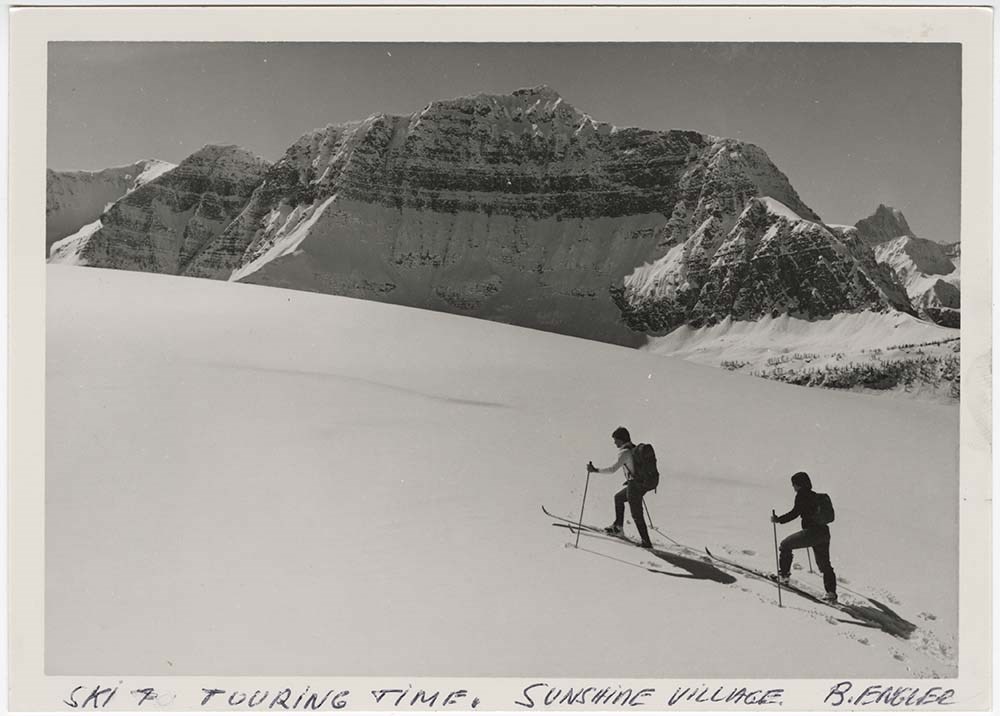
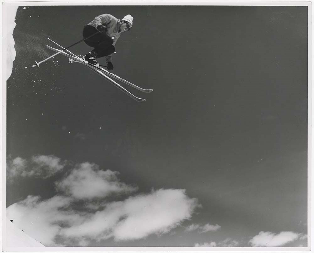
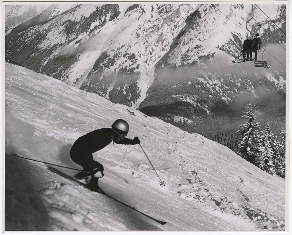
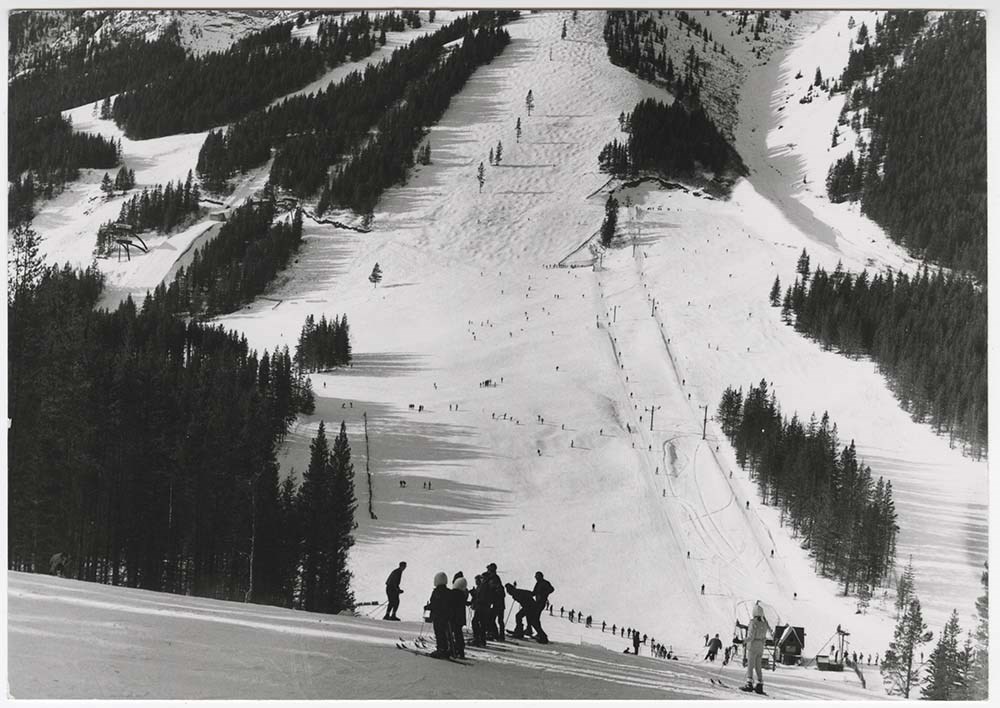
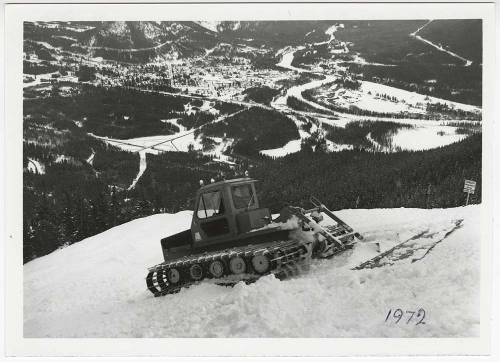
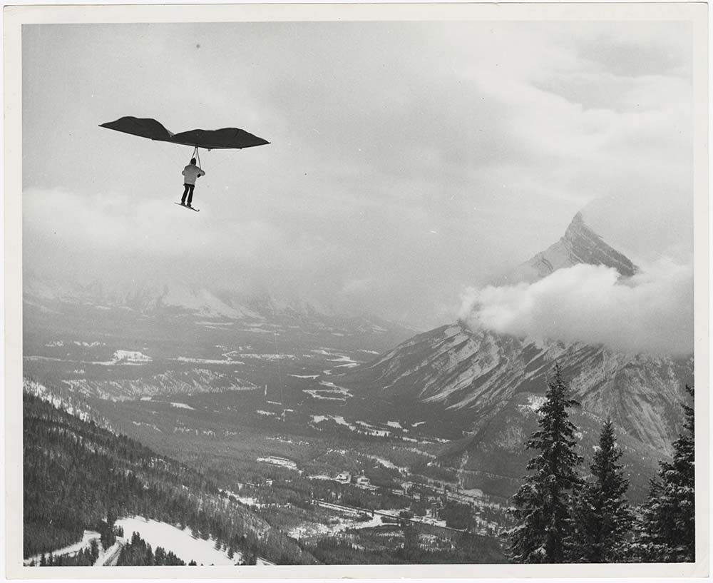
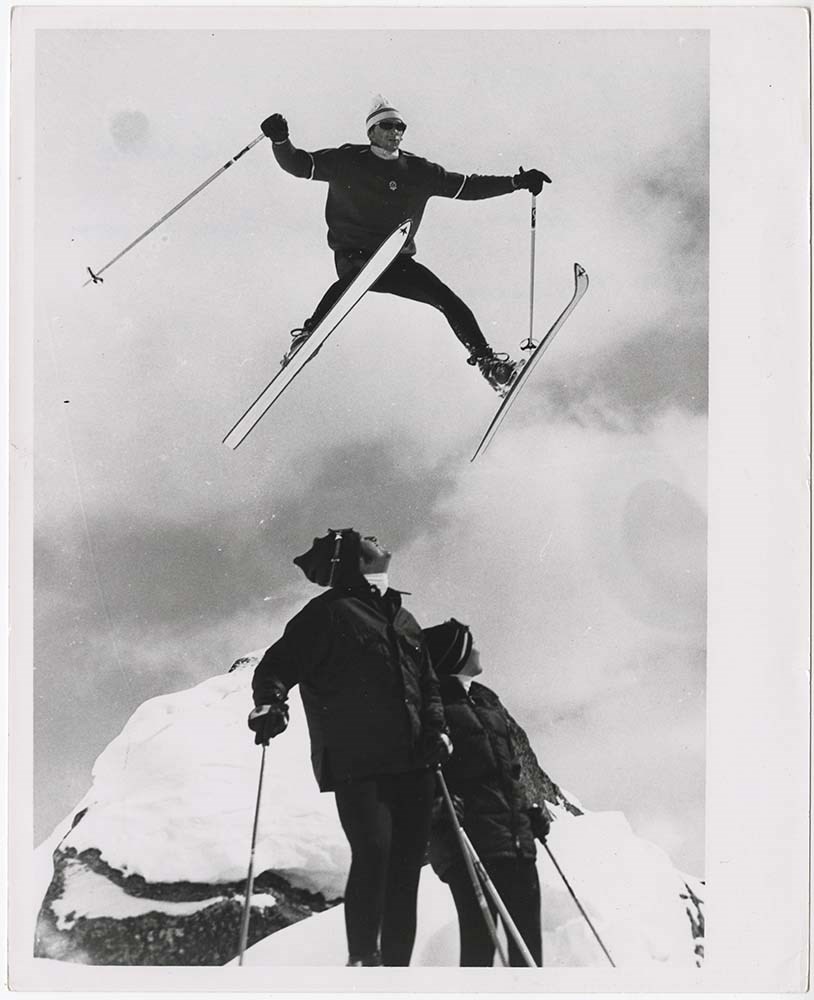
Action on Skis
https://archives.whyte.org/en/permalink/descriptions56697
- Part Of
- Bruno Engler fonds
- Scope & Content
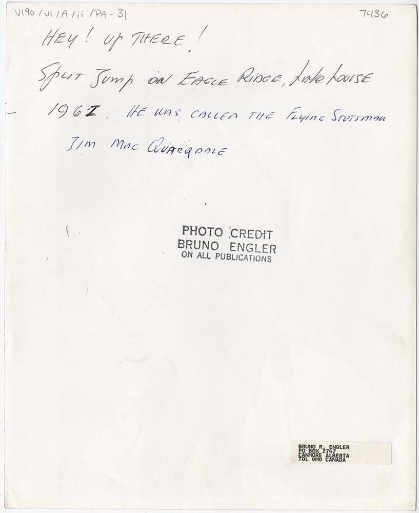
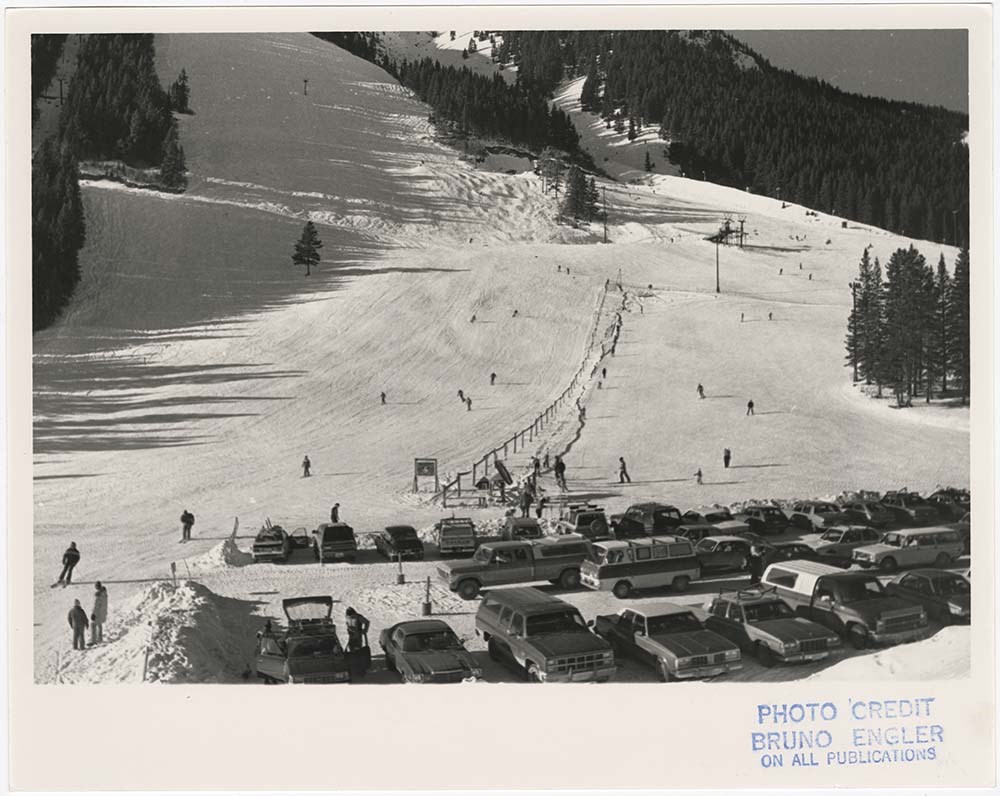
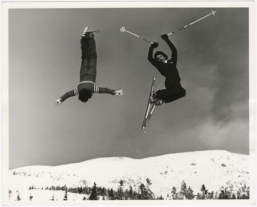
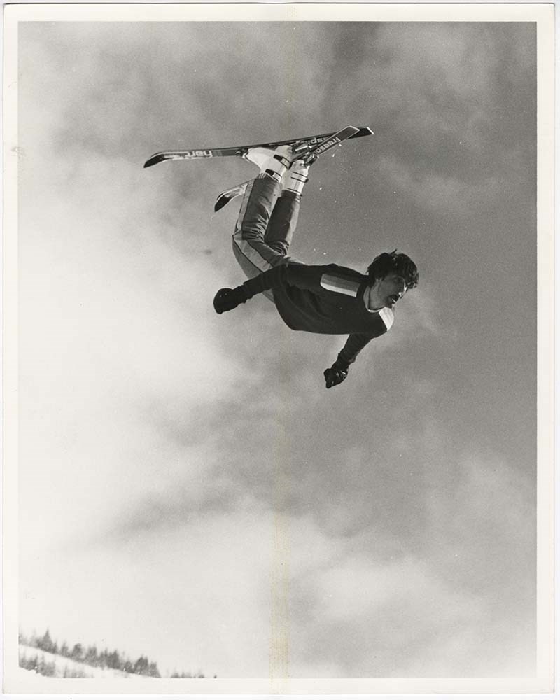
- File pertains to 38 b&w prints of people skiing. Includes action shots of people skiing at Norquay, Lake Louise, and Sunshine, the Norquay parking lot, ski jumping, ski racing, and an unidentified person paragliding on skis at Norquay.
- Date Range
- [ca. 1948-1980]
- Reference Code
- V190 / VI / A / ii / PA - 01 to PA - 38
- Description Level
- 5 / File
- GMD
- Photograph print
12 images
- Part Of
- Bruno Engler fonds
- Description Level
- 5 / File
- Fonds Number
- M323 / S40 / V190
- Series
- VI : Retained file, A : Alphabetical order
- Sous-Fonds
- V190
- Sub-Series
- ii : Action on Skis
- Accession Number
- 7436
- Reference Code
- V190 / VI / A / ii / PA - 01 to PA - 38
- Date Range
- [ca. 1948-1980]
- Physical Description
- 38 photographs : b&w ; 25.5 x 20.5 cm or smaller
- History / Biographical
- See fonds level description
- Scope & Content
- File pertains to 38 b&w prints of people skiing. Includes action shots of people skiing at Norquay, Lake Louise, and Sunshine, the Norquay parking lot, ski jumping, ski racing, and an unidentified person paragliding on skis at Norquay.
- Name Access
- Engler, Bruno
- Subject Access
- Activities
- Lake Louise Ski Area
- Mountains
- Norquay Ski Hill
- Ski areas
- Ski jumping
- Ski racing
- Skiing
- Sports and leisure
- Sunshine Ski Resort
- Winter
- Winter sports
- Geographic Access
- Banff
- Lake Louise
- Banff National Park
- Alberta
- Language
- English
- Creator
- Engler, Bruno
- Title Source
- Original title kept
- Processing Status
- Processed
Images
This material is presented as originally created; it may contain outdated cultural descriptions and
potentially offensive content.
Read more.
[Aishihik Lake 115H, Yukon]
https://archives.whyte.org/en/permalink/catalogue24002
- Medium
- Library - Maps and blueprints (unannotated; published)
- Map
- Published Date
- 1971
- Publisher
- Dept. of Energy, Mines and Resources
- Call Number
- NTS
- 115H
- Publisher
- Dept. of Energy, Mines and Resources
- Published Date
- 1971
- Physical Description
- 1 map : col
- Scale
- Scale: 1:250,000
- Relief: Contour interval 500 ft.
- Subjects
- Aishihik Lake
- Yukon Territory
- Notes
- National Topographic System
- Accession Number
- 3000
- Call Number
- NTS
- 115H
- Collection
- Archives Library
This material is presented as originally created; it may contain outdated cultural descriptions and
potentially offensive content.
Read more.
[Anahim Lake 93C, B.C.]
https://archives.whyte.org/en/permalink/catalogue24005
- Medium
- Library - Maps and blueprints (unannotated; published)
- Map
- Published Date
- 1955
- Publisher
- Dept. of Mines and Technical Surveys
- Call Number
- NTS
- 93C
- Publisher
- Dept. of Mines and Technical Surveys
- Published Date
- 1955
- Physical Description
- 1 map : col
- Scale
- Scale: 1:250,000
- Relief: Contour interval 500 ft.
- Subjects
- Anahim Lake
- British Columbia
- Accession Number
- 3000
- Call Number
- NTS
- 93C
- Collection
- Archives Library
This material is presented as originally created; it may contain outdated cultural descriptions and
potentially offensive content.
Read more.
[Anahim Lake, B.C.] Canada Land Inventory Map, Land capability for wildlife-ungulates
https://archives.whyte.org/en/permalink/catalogue24004
- Medium
- Library - Maps and blueprints (unannotated; published)
- Map
- Published Date
- 1971
- Publisher
- Dept. of Energy, Mines and Resources
- Call Number
- NTS
- 93C
- Publisher
- Dept. of Energy, Mines and Resources
- Published Date
- 1971
- Physical Description
- 1 map : col
- Scale
- Scale: 1:250,000
- Subjects
- Anahim Lake
- British Columbia
- Accession Number
- 4000
- Call Number
- NTS
- 93C
- Collection
- Archives Library
This material is presented as originally created; it may contain outdated cultural descriptions and
potentially offensive content.
Read more.
[Angus Horne Lake 83D/5 B.C.]
https://archives.whyte.org/en/permalink/catalogue23450
- Medium
- Library - Maps and blueprints (unannotated; published)
- Map
- Published Date
- 1972
- Publisher
- Department of Energy, Mines and Resources
- Call Number
- NTS
- 83D/5
- Publisher
- Department of Energy, Mines and Resources
- Published Date
- 1972
- Physical Description
- 1 map : col
- Scale
- Scale: 1:50,000
- Relief: Contour interval 100 ft.
- Subjects
- Angus Horne Lake
- British Columbia
- Notes
- National Topographic System
- Accession Number
- 7000
- Call Number
- NTS
- 83D/5
- Collection
- Archives Library
This material is presented as originally created; it may contain outdated cultural descriptions and
potentially offensive content.
Read more.
[Baffin Island 37E/8E] Bieler Lake East, District of Franklin, Northwest Territories
https://archives.whyte.org/en/permalink/catalogue23471
- Medium
- Library - Maps and blueprints (unannotated; published)
- Map
- Published Date
- 1964
- Publisher
- Department of Mines and Technical Surveys
- Call Number
- NTS
- 37E/8E
- Publisher
- Department of Mines and Technical Surveys
- Published Date
- 1964
- Physical Description
- 1 map : black and white
- Scale
- Scale: 1:50,000
- Relief: Contour intervals
- Notes
- Arctic provisional map
- National Topographic System
- Accession Number
- 7000
- Call Number
- NTS
- 37E/8E
- Collection
- Archives Library
This material is presented as originally created; it may contain outdated cultural descriptions and
potentially offensive content.
Read more.
[Baffin Island 37E/8W] Bieler Lake East, District of Franklin, Northwest Territories
https://archives.whyte.org/en/permalink/catalogue23472
- Medium
- Library - Maps and blueprints (unannotated; published)
- Map
- Published Date
- 1964
- Publisher
- Department of Mines and Technical Surveys
- Call Number
- NTS
- 37E/8E
- Publisher
- Department of Mines and Technical Surveys
- Published Date
- 1964
- Physical Description
- 1 map : black and white
- Scale
- Scale: 1:50,000
- Relief: Contour intervals
- Notes
- Arctic provisional map
- National Topographic System
- Accession Number
- 7000
- Call Number
- NTS
- 37E/8E
- Collection
- Archives Library
This material is presented as originally created; it may contain outdated cultural descriptions and
potentially offensive content.
Read more.
[Baffin Island, Bieler Lake East] District of Franklin, Northwest Territories
https://archives.whyte.org/en/permalink/catalogue23473
- Medium
- Library - Maps and blueprints (unannotated; published)
- Map
- Published Date
- 1964
- Publisher
- Department of Mines and Technical Surveys
- Call Number
- NTS
- 37E/8W
- Publisher
- Department of Mines and Technical Surveys
- Published Date
- 1964
- Physical Description
- 1 map : black and white
- Scale
- Scale: 1:50,000
- Relief: Contour intervals
- Notes
- National Topographic System
- Arctic provisional map
- Accession Number
- 7000
- Call Number
- NTS
- 37E/8W
- Collection
- Archives Library
This material is presented as originally created; it may contain outdated cultural descriptions and
potentially offensive content.
Read more.
[Baffin Island, Bieler Lake West, Barnes Ice Cap 37E/7E] District of Franklin, Northwest Territories
https://archives.whyte.org/en/permalink/catalogue23469
- Medium
- Library - Maps and blueprints (unannotated; published)
- Map
- Published Date
- 1964
- Publisher
- Department of Mines and Technical Surveys
- Call Number
- NTS
- 37E/7E
- Publisher
- Department of Mines and Technical Surveys
- Published Date
- 1964
- Physical Description
- 1 map : black and white
- Scale
- Scale: 1:50,000
- Relief: Contour intervals
- Subjects
- Baffin Island, Bieler Lake West, Barnes Ice Cap
- District of Franklin, Northwest Territories
- Notes
- National Topographic System
- Accession Number
- 7000
- Call Number
- NTS
- 37E/7E
- Collection
- Archives Library
This material is presented as originally created; it may contain outdated cultural descriptions and
potentially offensive content.
Read more.
[Baffin Island, Bieler Lake West, Barnes Ice Cap 37E/7W] District of Franklin, Northwest Territories
https://archives.whyte.org/en/permalink/catalogue23470
- Medium
- Library - Maps and blueprints (unannotated; published)
- Map
- Published Date
- 1964
- Publisher
- Department of Mines and Technical Surveys
- Call Number
- NTS
- 37E/7W
- Publisher
- Department of Mines and Technical Surveys
- Published Date
- 1964
- Physical Description
- 1 map : black and white
- Scale
- Scale: 1:50,000
- Relief: Contour intervals
- Subjects
- Baffin Island, Bieler Lake West, Barnes Ice Cap
- District of Franklin, Northwest Territories
- Notes
- National Topographic System
- Arctic provisional map
- Accession Number
- 7000
- Call Number
- NTS
- 37E/7W
- Collection
- Archives Library
This material is presented as originally created; it may contain outdated cultural descriptions and
potentially offensive content.
Read more.