Narrow Results By
- James (Sr.) Simpson (1877 – 1972, Canadian) 10
- Ernest C. W Lamarque (1879 – 1970, Canadian) 4
- Frederic Marlett Bell-Smith, R. C. A. (1846 – 1923, Canadian) 4
- Robert J. McGuinness (1886 – 1961, Canadian) 4
- Janet Holly Middleton (1922 – 2018, Canadian) 3
- John Hartman (1950 – , Canadian) 3
- Doris Cormie 2
- Thomas Mower Martin, R. C. A. (1838 – 1934, Canadian) 2
- Alfred Crocker Leighton, R. C. A. (1901 – 1965, Canadian) 1
- Barbara Spohr (1955 – 1987, Canadian) 1
- Bern Smith (1928 – 2009, Canadian) 1
- Catherine Perehudoff Fowler (1958 – , Canadian) 1
Airplane Lake, British Columbia
https://archives.whyte.org/en/permalink/artifactlae.05.02
- Date
- 1936
- Medium
- watercolour on paper
- Catalogue Number
- LaE.05.02
- Description
- General colour: light green, brown. The lake sits in the lower third of the picture between two points of grassy treed land. One comes from the left side across the bottom, the other from the right side, part way up to right of center. A brown mountain range rises up from the lake and to the right …
1 image
- Title
- Airplane Lake, British Columbia
- Date
- 1936
- Medium
- watercolour on paper
- Dimensions
- 26.9 x 43.5 cm
- Description
- General colour: light green, brown. The lake sits in the lower third of the picture between two points of grassy treed land. One comes from the left side across the bottom, the other from the right side, part way up to right of center. A brown mountain range rises up from the lake and to the right side. Sky beyond with two birds flying center and left.
- Subject
- landscape
- mountain
- lake
- Ernest Lamarque
- Credit
- Gift of Ernest Lamarque (Estate), 1971
- Catalogue Number
- LaE.05.02
Images

This material is presented as originally created; it may contain outdated cultural descriptions and
potentially offensive content.
Read more.
[Aishihik Lake 115H, Yukon]
https://archives.whyte.org/en/permalink/catalogue24002
- Medium
- Library - Maps and blueprints (unannotated; published)
- Map
- Published Date
- 1971
- Publisher
- Dept. of Energy, Mines and Resources
- Call Number
- NTS
- 115H
- Publisher
- Dept. of Energy, Mines and Resources
- Published Date
- 1971
- Physical Description
- 1 map : col
- Scale
- Scale: 1:250,000
- Relief: Contour interval 500 ft.
- Subjects
- Aishihik Lake
- Yukon Territory
- Notes
- National Topographic System
- Accession Number
- 3000
- Call Number
- NTS
- 115H
- Collection
- Archives Library
This material is presented as originally created; it may contain outdated cultural descriptions and
potentially offensive content.
Read more.
[Anahim Lake 93C, B.C.]
https://archives.whyte.org/en/permalink/catalogue24005
- Medium
- Library - Maps and blueprints (unannotated; published)
- Map
- Published Date
- 1955
- Publisher
- Dept. of Mines and Technical Surveys
- Call Number
- NTS
- 93C
- Publisher
- Dept. of Mines and Technical Surveys
- Published Date
- 1955
- Physical Description
- 1 map : col
- Scale
- Scale: 1:250,000
- Relief: Contour interval 500 ft.
- Subjects
- Anahim Lake
- British Columbia
- Accession Number
- 3000
- Call Number
- NTS
- 93C
- Collection
- Archives Library
This material is presented as originally created; it may contain outdated cultural descriptions and
potentially offensive content.
Read more.
[Anahim Lake, B.C.] Canada Land Inventory Map, Land capability for wildlife-ungulates
https://archives.whyte.org/en/permalink/catalogue24004
- Medium
- Library - Maps and blueprints (unannotated; published)
- Map
- Published Date
- 1971
- Publisher
- Dept. of Energy, Mines and Resources
- Call Number
- NTS
- 93C
- Publisher
- Dept. of Energy, Mines and Resources
- Published Date
- 1971
- Physical Description
- 1 map : col
- Scale
- Scale: 1:250,000
- Subjects
- Anahim Lake
- British Columbia
- Accession Number
- 4000
- Call Number
- NTS
- 93C
- Collection
- Archives Library
This material is presented as originally created; it may contain outdated cultural descriptions and
potentially offensive content.
Read more.
[Angus Horne Lake 83D/5 B.C.]
https://archives.whyte.org/en/permalink/catalogue23450
- Medium
- Library - Maps and blueprints (unannotated; published)
- Map
- Published Date
- 1972
- Publisher
- Department of Energy, Mines and Resources
- Call Number
- NTS
- 83D/5
- Publisher
- Department of Energy, Mines and Resources
- Published Date
- 1972
- Physical Description
- 1 map : col
- Scale
- Scale: 1:50,000
- Relief: Contour interval 100 ft.
- Subjects
- Angus Horne Lake
- British Columbia
- Notes
- National Topographic System
- Accession Number
- 7000
- Call Number
- NTS
- 83D/5
- Collection
- Archives Library
This material is presented as originally created; it may contain outdated cultural descriptions and
potentially offensive content.
Read more.
At Lake Minnewanka
https://archives.whyte.org/en/permalink/artifactcmd.05.05
- Artist
- Doris Cormie
- Date
- 1938
- Medium
- painting on paper
- Catalogue Number
- CmD.05.05
- Description
- A watercolour landscape painting of mountains and a lake. There are three grey mountains in the background and behind them is a cloudless blue sky. In the foreground is a blue-green lake. On the bottom right, part of the shore with three large rocks, is visible. In the centre at the bottom, a few b…
1 image
- Artist
- Doris Cormie
- Title
- At Lake Minnewanka
- Date
- 1938
- Medium
- painting on paper
- Dimensions
- 26.0 x 37.0 cm
- Description
- A watercolour landscape painting of mountains and a lake. There are three grey mountains in the background and behind them is a cloudless blue sky. In the foreground is a blue-green lake. On the bottom right, part of the shore with three large rocks, is visible. In the centre at the bottom, a few branches and two logs are breaking through the water. On the left side a large boulder sits in the water. In the middle ground there is forest along the lake shore. The forest starts out of frame on the right and extends just over halfway across the painting. Behind the forest on the left are two green hills. Greys, blues, greens and brown are the primary colours used. The artist signature is in the bottom rhc. Au verso, written in pencil along the bottom edge is, “At Lake Minnewanka aug 28/38 Doris Cormie” and also in pencil in the centre of the paper is “27” with a circle around it. Just right of centre near the top is written, “5334”.
- Subject
- landscape
- lake
- mountains
- Doris Cormie
- Credit
- Gift of Barry Hunter Gillis, Richmond, 2006
- Catalogue Number
- CmD.05.05
Images

This material is presented as originally created; it may contain outdated cultural descriptions and
potentially offensive content.
Read more.
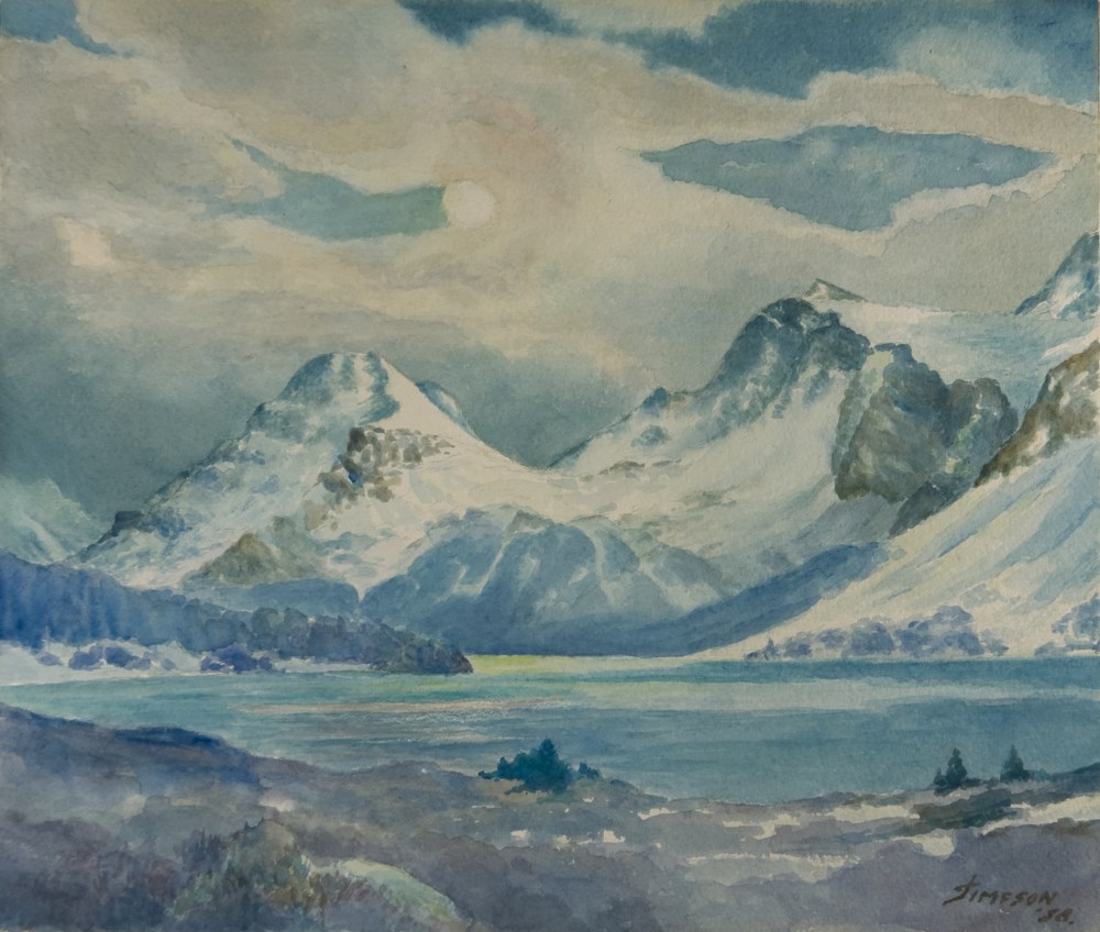
Autumn Evening, 1958
https://archives.whyte.org/en/permalink/artifactsij.05.60
- Date
- 1958
- Medium
- watercolour on paper
- Catalogue Number
- SiJ.05.60
- Description
- Cloudy, moonlit scene, mountains in background stretch across image, Bow Lake at the foot of the mountains in the foreground. In the immediate foreground at the bottom of the image is the shore of the lake, a few trees on it. At the centre left of the image, a line of trees on the bank extends i…
1 image
- Title
- Autumn Evening, 1958
- Date
- 1958
- Medium
- watercolour on paper
- Description
- Cloudy, moonlit scene, mountains in background stretch across image, Bow Lake at the foot of the mountains in the foreground. In the immediate foreground at the bottom of the image is the shore of the lake, a few trees on it. At the centre left of the image, a line of trees on the bank extends in towards the middle of the image.
- Subject
- landscape
- Canadian Rockies
- Bow Lake
- Credit
- Gift of James (Jr.) Simpson, Rocky Mountain House, 2000
- Catalogue Number
- SiJ.05.60
Images
This material is presented as originally created; it may contain outdated cultural descriptions and
potentially offensive content.
Read more.
[Baffin Island 37E/8E] Bieler Lake East, District of Franklin, Northwest Territories
https://archives.whyte.org/en/permalink/catalogue23471
- Medium
- Library - Maps and blueprints (unannotated; published)
- Map
- Published Date
- 1964
- Publisher
- Department of Mines and Technical Surveys
- Call Number
- NTS
- 37E/8E
- Publisher
- Department of Mines and Technical Surveys
- Published Date
- 1964
- Physical Description
- 1 map : black and white
- Scale
- Scale: 1:50,000
- Relief: Contour intervals
- Notes
- Arctic provisional map
- National Topographic System
- Accession Number
- 7000
- Call Number
- NTS
- 37E/8E
- Collection
- Archives Library
This material is presented as originally created; it may contain outdated cultural descriptions and
potentially offensive content.
Read more.
[Baffin Island 37E/8W] Bieler Lake East, District of Franklin, Northwest Territories
https://archives.whyte.org/en/permalink/catalogue23472
- Medium
- Library - Maps and blueprints (unannotated; published)
- Map
- Published Date
- 1964
- Publisher
- Department of Mines and Technical Surveys
- Call Number
- NTS
- 37E/8E
- Publisher
- Department of Mines and Technical Surveys
- Published Date
- 1964
- Physical Description
- 1 map : black and white
- Scale
- Scale: 1:50,000
- Relief: Contour intervals
- Notes
- Arctic provisional map
- National Topographic System
- Accession Number
- 7000
- Call Number
- NTS
- 37E/8E
- Collection
- Archives Library
This material is presented as originally created; it may contain outdated cultural descriptions and
potentially offensive content.
Read more.
[Baffin Island, Bieler Lake East] District of Franklin, Northwest Territories
https://archives.whyte.org/en/permalink/catalogue23473
- Medium
- Library - Maps and blueprints (unannotated; published)
- Map
- Published Date
- 1964
- Publisher
- Department of Mines and Technical Surveys
- Call Number
- NTS
- 37E/8W
- Publisher
- Department of Mines and Technical Surveys
- Published Date
- 1964
- Physical Description
- 1 map : black and white
- Scale
- Scale: 1:50,000
- Relief: Contour intervals
- Notes
- National Topographic System
- Arctic provisional map
- Accession Number
- 7000
- Call Number
- NTS
- 37E/8W
- Collection
- Archives Library
This material is presented as originally created; it may contain outdated cultural descriptions and
potentially offensive content.
Read more.