Narrow Results By
- Alpine Club of Canada fonds 52
- Bruno Engler fonds 24
- Peter and Catharine Whyte fonds 15
- Trail Riders of the Canadian Rockies fonds 11
- Douglas Leighton fonds 9
- Lillian Gest fonds 5
- Murray Hay fonds 3
- Nicholas Morant fonds 3
- George Paris fonds 2
- Luxton family fonds 2
- Bruce Hatfield fonds 1
- Calgary Mountain Club fonds 1
- Alpine Club of Canada 52
- Engler, Bruno 24
- Robert William Sinclair (1939 – , Canadian) 15
- Douglas Leighton 9
- Leighton, Douglas 9
- Canada. Environment Canada. Parks. Western Region 8
- Ron Brown (1955 – , Canadian) 6
- Alice Saltiel (1948 – , Canadian) 5
- Dorothy Elsie Knowles Perehudoff (1927 – 2023, Canadian) 5
- Gest, Lillian 5
- Auger, Tim 4
- Canadian Parks Service. Western Region 4
Topographical sheet
https://archives.whyte.org/en/permalink/catalogue24646
- Medium
- Library - Maps and blueprints (unannotated; published)
- Map
- Published Date
- 1890
- Publisher
- Dept. of the Interior
- Call Number
- C3-8.6
- Publisher
- Dept. of the Interior
- Published Date
- 1890
- Scale
- Scale: 1:40,000
- Relief: Contour interval 100 ft.
- Subjects
- Castle Mountain
- Notes
- Photostatic copy from Public Archives
- Accession Number
- 675
- Call Number
- C3-8.6
- Collection
- Archives Library
This material is presented as originally created; it may contain outdated cultural descriptions and
potentially offensive content.
Read more.
Topographical sheet
https://archives.whyte.org/en/permalink/catalogue24648
- Medium
- Library - Maps and blueprints (unannotated; published)
- Map
- Published Date
- 1890
- Publisher
- Dept. of the Interior
- Call Number
- C3-8.8
- Publisher
- Dept. of the Interior
- Published Date
- 1890
- Scale
- Scale: 1:40,000
- Relief: Contour interval 100 ft.
- Subjects
- Cascade Mountain
- Notes
- Photostatic copy from Public Archives
- Accession Number
- 675
- Call Number
- C3-8.8
- Collection
- Archives Library
This material is presented as originally created; it may contain outdated cultural descriptions and
potentially offensive content.
Read more.
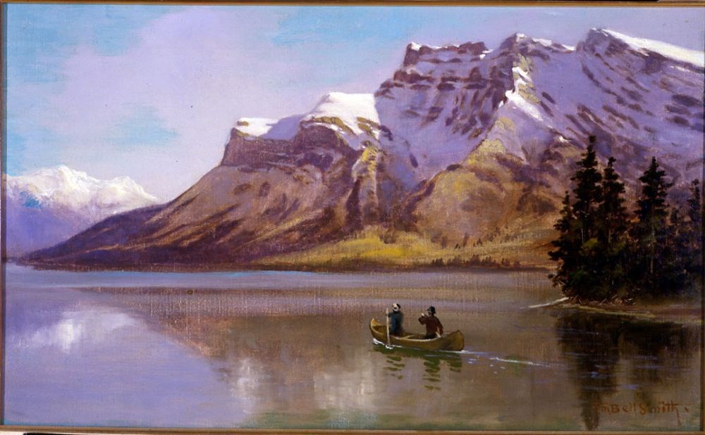
Lake Minnewanka and Mount Inglismaldie
https://archives.whyte.org/en/permalink/artifactbes.02.01
- Date
- 1890
- Medium
- oil on canvas
- Catalogue Number
- BeS.02.01
- Description
- Colour: blue, green. The lower half is a lake with two people in a canoe right of center. A piece of land with evergreens comes out at the right side. The upper half is a mountain range. At the left side in the distance is another range. Above is clear blue sky.This painting was lent to the Winnipe…
1 image
- Title
- Lake Minnewanka and Mount Inglismaldie
- Date
- 1890
- Medium
- oil on canvas
- Dimensions
- 34.0 x 57.0 cm
- Description
- Colour: blue, green. The lower half is a lake with two people in a canoe right of center. A piece of land with evergreens comes out at the right side. The upper half is a mountain range. At the left side in the distance is another range. Above is clear blue sky.This painting was lent to the Winnipeg Art Gallery in 1975 to be included in the exhibition The Railway: A Patron of the Arts in Canada. The exhibition was circulated accross the country for two years.
- Credit
- Purchased from Red River Books, 1968
- Catalogue Number
- BeS.02.01
Images
This material is presented as originally created; it may contain outdated cultural descriptions and
potentially offensive content.
Read more.
Topographical sheet
https://archives.whyte.org/en/permalink/catalogue24656
- Medium
- Library - Maps and blueprints (unannotated; published)
- Map
- Published Date
- 1891
- Publisher
- Dept. of the Interior
- Call Number
- C3-8.16
- Publisher
- Dept. of the Interior
- Published Date
- 1891
- Scale
- Scale: 1:40,000
- Relief: Contour interval 100 ft.
- Subjects
- End Mountain
- Notes
- Photostatic copy from Public Archives
- Accession Number
- 675
- Call Number
- C3-8.16
- Collection
- Archives Library
This material is presented as originally created; it may contain outdated cultural descriptions and
potentially offensive content.
Read more.
Topographical sheet
https://archives.whyte.org/en/permalink/catalogue24651
- Medium
- Library - Maps and blueprints (unannotated; published)
- Map
- Published Date
- 1892
- Publisher
- Dept. of the Interior
- Call Number
- C3-8.11
- Publisher
- Dept. of the Interior
- Published Date
- 1892
- Scale
- Scale: 1:40,000
- Relief: Contour interval 100 ft.
- Subjects
- Copper Mountain
- Notes
- Photostatic copy from Public Archives
- Accession Number
- 675
- Call Number
- C3-8.11
- Collection
- Archives Library
This material is presented as originally created; it may contain outdated cultural descriptions and
potentially offensive content.
Read more.
Topographical sheets
https://archives.whyte.org/en/permalink/catalogue24652
- Medium
- Library - Maps and blueprints (unannotated; published)
- Map
- Published Date
- 1892
- Publisher
- Dept. of the Interior
- Call Number
- C3-8.12
- Publisher
- Dept. of the Interior
- Published Date
- 1892
- Scale
- Scale: 1: 40,000
- Relief: Contour interval 100 ft.
- Subjects
- Pilot Mountain
- Notes
- Photostatic copy from Public Archives
- Accession Number
- 675
- Call Number
- C3-8.12
- Collection
- Archives Library
This material is presented as originally created; it may contain outdated cultural descriptions and
potentially offensive content.
Read more.
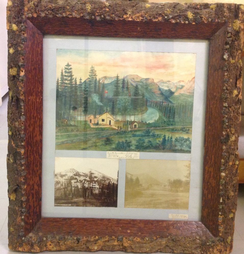
Castle Mountain Siding
https://archives.whyte.org/en/permalink/artifactzoc.13.01
- Artist
- C. Zollern
- Date
- 1895
- Medium
- watercolour; photograph on paper
- Catalogue Number
- ZoC.13.01
- Description
- Colour: green, yellow. Three frames inside one. Top picture is a painting of a group of wooden buildings left of center with a flag pole (flag is flying) and antlers on the roof. In front are railway tracks with a team of four workers going along on a cart. Behind is a river with a man fishing in i…
1 image
- Artist
- C. Zollern
- Title
- Castle Mountain Siding
- Date
- 1895
- Medium
- watercolour; photograph on paper
- Dimensions
- 34.8 x 47.5 cm
- Description
- Colour: green, yellow. Three frames inside one. Top picture is a painting of a group of wooden buildings left of center with a flag pole (flag is flying) and antlers on the roof. In front are railway tracks with a team of four workers going along on a cart. Behind is a river with a man fishing in it on the right. On both sides of the river are trees and in the distance are mountains. Sky fills the top. The lower two pictures are photographs. The left is of the first Banff Springs Hotel and Rundle Mountain. The right is looking down the main street of Banff in 1895.
- Credit
- Gift of Catharine Robb Whyte, O. C., Banff, 1974
- Catalogue Number
- ZoC.13.01
Images
This material is presented as originally created; it may contain outdated cultural descriptions and
potentially offensive content.
Read more.
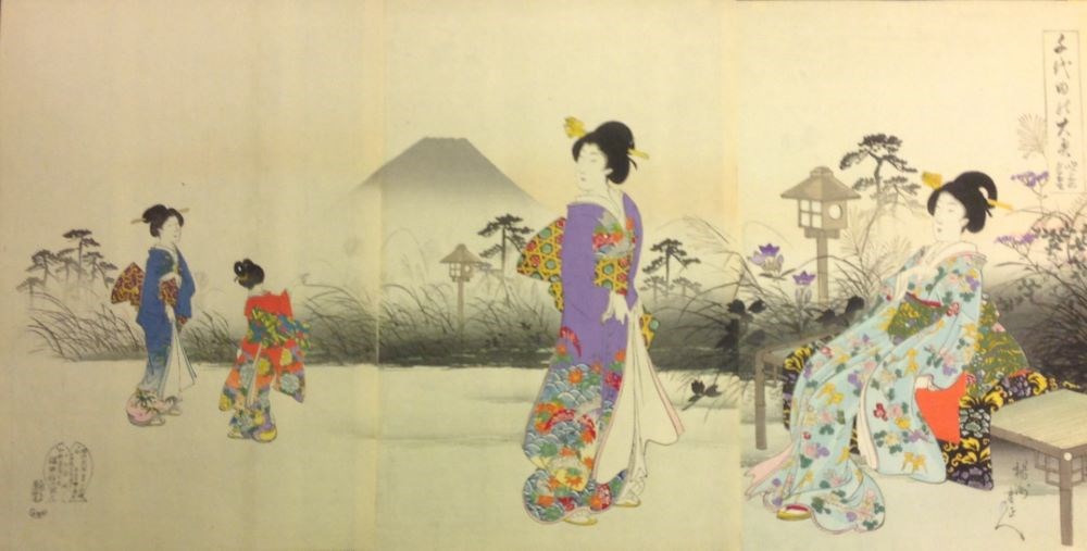
Evening Mt. Fuji During the Upward Wind
https://archives.whyte.org/en/permalink/artifactchy.04.08%20a-c
- Date
- 1895
- Medium
- woodblock on paper
- Catalogue Number
- ChY.04.08 a-c
- Description
- This triptych features four women spread across three panels with Mt. Fuji softly in the background. A stretch of bushes separated the women from the background and is mostly grey. The lone Mt. Fuji is the only background with paper tone behind it. In the first panel Mt. Fuji starts and two wome…
1 image
- Title
- Evening Mt. Fuji During the Upward Wind
- Date
- 1895
- Medium
- woodblock on paper
- Dimensions
- 37 x 72 cm
- Description
- This triptych features four women spread across three panels with Mt. Fuji softly in the background. A stretch of bushes separated the women from the background and is mostly grey. The lone Mt. Fuji is the only background with paper tone behind it. In the first panel Mt. Fuji starts and two women stand with their bodies facing eachother. The smaller woman is pointing at Mt. Fuji. In the second panel a woman stands in the rc, her body facing right and her head turned back to the left. She has her back to the mountain which is mostly featured in the second panel. In the third panel a woman sits on a bench facing left with her hand by her chest. A lamp is to the left of her bench. The ground the woman are on is mostly paper tone with a light wash.
- Credit
- Gift of Catharine Robb Whyte, O. C., Banff, 1979
- Catalogue Number
- ChY.04.08 a-c
Images
This material is presented as originally created; it may contain outdated cultural descriptions and
potentially offensive content.
Read more.
Argonaut Mountain, Kootenay Land District, British Columbia
https://archives.whyte.org/en/permalink/catalogue23451
- Medium
- Library - Maps and blueprints (unannotated; published)
- Map
- Published Date
- 1980
- Publisher
- Ottawa: Surveys and Mapping Branch, Dept. of Energy, Mines and Resources
- Edition
- 2d ed.
- Call Number
- NTS
- 82M/16
- Edition
- 2d ed.
- Publisher
- Ottawa: Surveys and Mapping Branch, Dept. of Energy, Mines and Resources
- Published Date
- 1980
- Physical Description
- 1 map : col
- Scale
- Scale: 1:50,000
- Subjects
- Argonaut Mountain
- British Columbia
- Accession Number
- 27,000
- 7030
- Call Number
- NTS
- 82M/16
- Collection
- Archives Library
This material is presented as originally created; it may contain outdated cultural descriptions and
potentially offensive content.
Read more.
[Canoe Mountain]
https://archives.whyte.org/en/permalink/catalogue23537
- Medium
- Library - Maps and blueprints (unannotated; published)
- Map
- Published Date
- 1980
- Publisher
- Dept. of Energy, Mines and Resources
- Edition
- Edition 2
- Call Number
- NTS
- 83D/11
- Edition
- Edition 2
- Publisher
- Dept. of Energy, Mines and Resources
- Published Date
- 1980
- Physical Description
- 1 map : col
- Scale
- Scale: 1:50,000
- Relief: Contour Interval 100 ft.
- Subjects
- Canoe Mountain
- Notes
- National Topographic System
- Accession Number
- 13,000
- Call Number
- NTS
- 83D/11
- Collection
- Archives Library
This material is presented as originally created; it may contain outdated cultural descriptions and
potentially offensive content.
Read more.