Narrow Results By
- Peter Whyte (1905 – 1966, Canadian) 293
- Catharine Robb Whyte, O. C. (1906 – 1979, Canadian) 143
- Les Graff (1936 – , Canadian) 30
- Carl Clemens Moritz Rungius (1869 – 1959, American) 18
- Peter or Catharine Whyte 7
- Belmore Browne (1880 – 1954, American) 6
- Sydney C. Vick (1855 – 1922, Canadian) 4
- Unknown 4
- Frederic Marlett Bell-Smith, R. C. A. (1846 – 1923, Canadian) 3
- Henry George Glyde (1906 – 1998, Canadian) 3
- Clarence Ingwall Tillenius (1913 – 2012, Canadian) 2
- Edmee Moore (1908 – 1971, Canadian) 2
Drawing of Rocky Mountain by J.L.*
https://archives.whyte.org/en/permalink/catalogue21324
- Medium
- Library - Maps and blueprints (unannotated; published)
- Map
- Published Date
- 1873
- Call Number
- C4-5.2
- Published Date
- 1873
- Subjects
- Rocky Mountain House
- Notes
- Photostatic copy from Public Archives * See The Cairn, vol III, no. 2 last page re: Jean L'Heureux by E.J. Hart
- * See: The Cairn, vol III, no. 2 last page re: Jean L'Hereux by E.J. Hart
- Accession Number
- 675
- Call Number
- C4-5.2
- Collection
- Archives Library
This material is presented as originally created; it may contain outdated cultural descriptions and
potentially offensive content.
Read more.
Topographical sheet
https://archives.whyte.org/en/permalink/catalogue24655
- Medium
- Library - Maps and blueprints (unannotated; published)
- Map
- Published Date
- 1889
- Publisher
- Dept. of the Interior
- Call Number
- C3-8.15
- Publisher
- Dept. of the Interior
- Published Date
- 1889
- Scale
- Scale: 1:40,000
- Relief: Contour interval 100 ft.
- Subjects
- Saddle Mountain
- Notes
- Photostatic copy from Public Archives
- Accession Number
- 675
- Call Number
- C3-8.15
- Collection
- Archives Library
This material is presented as originally created; it may contain outdated cultural descriptions and
potentially offensive content.
Read more.
Topographical sheet
https://archives.whyte.org/en/permalink/catalogue24646
- Medium
- Library - Maps and blueprints (unannotated; published)
- Map
- Published Date
- 1890
- Publisher
- Dept. of the Interior
- Call Number
- C3-8.6
- Publisher
- Dept. of the Interior
- Published Date
- 1890
- Scale
- Scale: 1:40,000
- Relief: Contour interval 100 ft.
- Subjects
- Castle Mountain
- Notes
- Photostatic copy from Public Archives
- Accession Number
- 675
- Call Number
- C3-8.6
- Collection
- Archives Library
This material is presented as originally created; it may contain outdated cultural descriptions and
potentially offensive content.
Read more.
Topographical sheet
https://archives.whyte.org/en/permalink/catalogue24648
- Medium
- Library - Maps and blueprints (unannotated; published)
- Map
- Published Date
- 1890
- Publisher
- Dept. of the Interior
- Call Number
- C3-8.8
- Publisher
- Dept. of the Interior
- Published Date
- 1890
- Scale
- Scale: 1:40,000
- Relief: Contour interval 100 ft.
- Subjects
- Cascade Mountain
- Notes
- Photostatic copy from Public Archives
- Accession Number
- 675
- Call Number
- C3-8.8
- Collection
- Archives Library
This material is presented as originally created; it may contain outdated cultural descriptions and
potentially offensive content.
Read more.
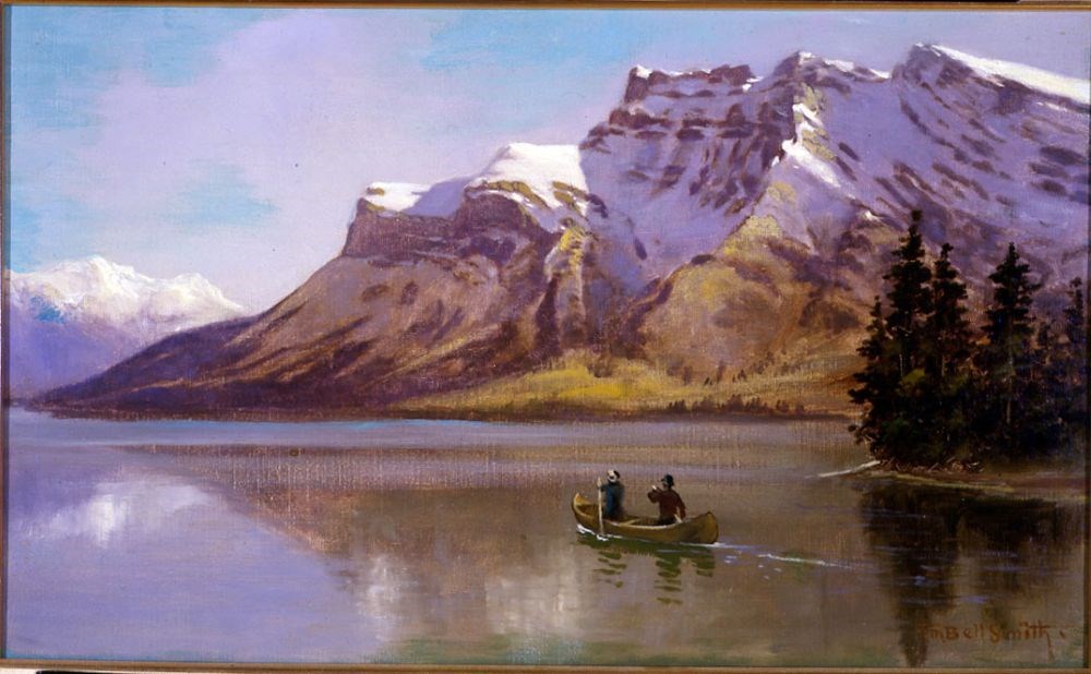
Lake Minnewanka and Mount Inglismaldie
https://archives.whyte.org/en/permalink/artifactbes.02.01
- Date
- 1890
- Medium
- oil on canvas
- Catalogue Number
- BeS.02.01
- Description
- Colour: blue, green. The lower half is a lake with two people in a canoe right of center. A piece of land with evergreens comes out at the right side. The upper half is a mountain range. At the left side in the distance is another range. Above is clear blue sky.This painting was lent to the Winnipe…
1 image
- Title
- Lake Minnewanka and Mount Inglismaldie
- Date
- 1890
- Medium
- oil on canvas
- Dimensions
- 34.0 x 57.0 cm
- Description
- Colour: blue, green. The lower half is a lake with two people in a canoe right of center. A piece of land with evergreens comes out at the right side. The upper half is a mountain range. At the left side in the distance is another range. Above is clear blue sky.This painting was lent to the Winnipeg Art Gallery in 1975 to be included in the exhibition The Railway: A Patron of the Arts in Canada. The exhibition was circulated accross the country for two years.
- Credit
- Purchased from Red River Books, 1968
- Catalogue Number
- BeS.02.01
Images
This material is presented as originally created; it may contain outdated cultural descriptions and
potentially offensive content.
Read more.
Topographical sheet
https://archives.whyte.org/en/permalink/catalogue24656
- Medium
- Library - Maps and blueprints (unannotated; published)
- Map
- Published Date
- 1891
- Publisher
- Dept. of the Interior
- Call Number
- C3-8.16
- Publisher
- Dept. of the Interior
- Published Date
- 1891
- Scale
- Scale: 1:40,000
- Relief: Contour interval 100 ft.
- Subjects
- End Mountain
- Notes
- Photostatic copy from Public Archives
- Accession Number
- 675
- Call Number
- C3-8.16
- Collection
- Archives Library
This material is presented as originally created; it may contain outdated cultural descriptions and
potentially offensive content.
Read more.
Topographical sheet
https://archives.whyte.org/en/permalink/catalogue24651
- Medium
- Library - Maps and blueprints (unannotated; published)
- Map
- Published Date
- 1892
- Publisher
- Dept. of the Interior
- Call Number
- C3-8.11
- Publisher
- Dept. of the Interior
- Published Date
- 1892
- Scale
- Scale: 1:40,000
- Relief: Contour interval 100 ft.
- Subjects
- Copper Mountain
- Notes
- Photostatic copy from Public Archives
- Accession Number
- 675
- Call Number
- C3-8.11
- Collection
- Archives Library
This material is presented as originally created; it may contain outdated cultural descriptions and
potentially offensive content.
Read more.
Topographical sheets
https://archives.whyte.org/en/permalink/catalogue24652
- Medium
- Library - Maps and blueprints (unannotated; published)
- Map
- Published Date
- 1892
- Publisher
- Dept. of the Interior
- Call Number
- C3-8.12
- Publisher
- Dept. of the Interior
- Published Date
- 1892
- Scale
- Scale: 1: 40,000
- Relief: Contour interval 100 ft.
- Subjects
- Pilot Mountain
- Notes
- Photostatic copy from Public Archives
- Accession Number
- 675
- Call Number
- C3-8.12
- Collection
- Archives Library
This material is presented as originally created; it may contain outdated cultural descriptions and
potentially offensive content.
Read more.
Special edition map showing lands disposed of
https://archives.whyte.org/en/permalink/catalogue24587
- Medium
- Library - Maps and blueprints (unannotated; published)
- Map
- Published Date
- 1908
- Publisher
- Dept. of the Interior
- Call Number
- C11-6.10
- Publisher
- Dept. of the Interior
- Published Date
- 1908
- Scale
- 6 miles - 1 inch
- Notes
- Sectional map
- References: Trails, Trails surveyed, Post Offices, Railway Stations, Range numbers, Township numbers...
- Accession Number
- 400
- Call Number
- C11-6.10
- Collection
- Archives Library
This material is presented as originally created; it may contain outdated cultural descriptions and
potentially offensive content.
Read more.
Special edition map showing lands disposed of
https://archives.whyte.org/en/permalink/catalogue24588
- Medium
- Library - Maps and blueprints (unannotated; published)
- Map
- Published Date
- 1908
- Publisher
- Dept. of the Interior
- Call Number
- C11-6.11
- Publisher
- Dept. of the Interior
- Published Date
- 1908
- Scale
- 6 miles - 1 inch
- Notes
- Sectional map
- References: Trails, Trails surveyed, Post Offices, Railway Stations, Range numbers, Township numbers....
- Accession Number
- 400
- Call Number
- C11-6.11
- Collection
- Archives Library
This material is presented as originally created; it may contain outdated cultural descriptions and
potentially offensive content.
Read more.