Narrow Results By
[Atlantic Ocean]
https://archives.whyte.org/en/permalink/catalogue24848
- Medium
- Library - Maps and blueprints (unannotated; published)
- Map
- Published Date
- 1939
- Publisher
- National Geographic Society
- Call Number
- C13-9.1
- Publisher
- National Geographic Society
- Published Date
- 1939
- Scale
- 316 miles to 1 inch
- Subjects
- Atlantic Ocean
- Accession Number
- 400
- Call Number
- C13-9.1
- Collection
- Archives Library
This material is presented as originally created; it may contain outdated cultural descriptions and
potentially offensive content.
Read more.
[Ocean Falls - Ootsa Lake 93SW, B.C.]
https://archives.whyte.org/en/permalink/catalogue24193
- Medium
- Library - Maps and blueprints (unannotated; published)
- Map
- Published Date
- 1965
- Publisher
- Dept. of Mines and Technical Surveys
- Call Number
- NTS
- 93SW
- Publisher
- Dept. of Mines and Technical Surveys
- Published Date
- 1965
- Scale
- Scale: 1:500,000
- Altitude tints
- Subjects
- Ocean Falls - Ootsa Lake
- British Columbia
- Notes
- National Topographic System
- Accession Number
- 3000
- Call Number
- NTS
- 93SW
- Collection
- Archives Library
This material is presented as originally created; it may contain outdated cultural descriptions and
potentially offensive content.
Read more.
[Pacific Ocean]
https://archives.whyte.org/en/permalink/catalogue24838
- Medium
- Library - Maps and blueprints (unannotated; published)
- Map
- Published Date
- 1936
- Publisher
- National Geographic Society
- Call Number
- C13-6.2
- Publisher
- National Geographic Society
- Published Date
- 1936
- Scale
- 552.4 miles to 1 inch
- Subjects
- Pacific Ocean
- Accession Number
- 400
- Call Number
- C13-6.2
- Collection
- Archives Library
This material is presented as originally created; it may contain outdated cultural descriptions and
potentially offensive content.
Read more.
Perspective Range
https://archives.whyte.org/en/permalink/artifactbel.06.01
- Date
- 1982
- Medium
- ceramic
- Catalogue Number
- BeL.06.01
- Description
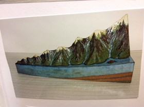
- A pie-shaped sculpture of a mountain range. The mountains gradually get taller, the shortest ones being at the tip of the wedge. On one side of the mountain range is a patchwork of prairies. On the other side is the Pacific Ocean. Along the bottom and back of the sculpture, the strata of the ea…
1 image
- Title
- Perspective Range
- Date
- 1982
- Medium
- ceramic
- Dimensions
- 31.75 x 21.59 x 44.45 cm
- Description
- A pie-shaped sculpture of a mountain range. The mountains gradually get taller, the shortest ones being at the tip of the wedge. On one side of the mountain range is a patchwork of prairies. On the other side is the Pacific Ocean. Along the bottom and back of the sculpture, the strata of the earth is visible. The mountains are snow-capped and rivers run down either side of them, perhaps representing the Great Divide.
- Credit
- Gift of Lorne Beug, Regina, 2001
- Catalogue Number
- BeL.06.01
Images
This material is presented as originally created; it may contain outdated cultural descriptions and
potentially offensive content.
Read more.


