Narrow Results By
- Peter Whyte (1905 – 1966, Canadian) 18
- Catharine Robb Whyte, O. C. (1906 – 1979, Canadian) 6
- Frederic Marlett Bell-Smith, R. C. A. (1846 – 1923, Canadian) 2
- George Weber (1907 – 2002, Canadian) 2
- Palmer, Howard 2
- Band, George 1
- Barry, John 1
- Belmore Browne (1880 – 1954, American) 1
- Brower, Kenneth 1
- Clinch, Nicholas B 1
- Corrigan, Buck 1
- Dainelli, Giotto 1
- Map 53
- Library - Maps and blueprints (unannotated; published) 52
- Library - Book (including soft-cover and pamphlets) 35
- Graphite Drawing 14
- Oil Painting 11
- Ink Drawing 2
- Serigraph Print 2
- Commemorative Plaque 1
- Graphite 1
- Library - Moving image (includes film and digital video - published) 1
- Library - Periodical 1
- Photograph 1
An unexplored pass : a narrative of a thousand mile journey to the Kara-koram Himalaya
https://archives.whyte.org/en/permalink/catalogue973
- Medium
- Library - Book (including soft-cover and pamphlets)
- Published Date
- 1926
- Author
- Featherstone, Belford Kinchant
- Publisher
- London : Hutchinson
- Call Number
- DS485 H6 F4
- Publisher
- London : Hutchinson
- Published Date
- 1926
- Subjects
- Karakoram Range
- Notes
- Edward C. Porter Mountaineering Library
- Call Number
- DS485 H6 F4
- Collection
- Alpine Club of Canada Library
This material is presented as originally created; it may contain outdated cultural descriptions and
potentially offensive content.
Read more.
(area adjacent to Jasper Park)
https://archives.whyte.org/en/permalink/catalogue24891
- Medium
- Library - Book (including soft-cover and pamphlets)
- Map
- Published Date
- November 4, 1920
- Publisher
- Department of the Interior
- Call Number
- C-7.47
- Publisher
- Department of the Interior
- Published Date
- November 4, 1920
- Physical Description
- 1 map : black and white
- Scale
- 40 chains: 1 inch
- Accession Number
- SG7500
- Call Number
- C-7.47
- Collection
- Archives Library
This material is presented as originally created; it may contain outdated cultural descriptions and
potentially offensive content.
Read more.
(Athabaska River area) - junction with Snarling River
https://archives.whyte.org/en/permalink/catalogue24502
- Medium
- Library - Maps and blueprints (unannotated; published)
- Map
- Published Date
- February 24, 1911
- Publisher
- Department of the Interior
- Call Number
- C9-7.46
- Publisher
- Department of the Interior
- Published Date
- February 24, 1911
- Physical Description
- 1 map : black and white
- Scale
- 40 chains: 1 inch
- Accession Number
- SG7500
- Call Number
- C9-7.46
- Collection
- Archives Library
This material is presented as originally created; it may contain outdated cultural descriptions and
potentially offensive content.
Read more.
(Athabaska River-Talbot Lake area)
https://archives.whyte.org/en/permalink/catalogue24508
- Medium
- Library - Maps and blueprints (unannotated; published)
- Map
- Published Date
- October 19, 1911
- Publisher
- Department of the Interior
- Call Number
- C9-7.48
- Publisher
- Department of the Interior
- Published Date
- October 19, 1911
- Physical Description
- 1 map : black and white
- Scale
- 40 chains: 1 inch
- Accession Number
- SG7500
- Call Number
- C9-7.48
- Collection
- Archives Library
This material is presented as originally created; it may contain outdated cultural descriptions and
potentially offensive content.
Read more.
Attempts to ascend Mustagh-Ata
https://archives.whyte.org/en/permalink/catalogue1291
- Medium
- Library - Book (including soft-cover and pamphlets)
- Author
- Hedin, Sven Anders
- Call Number
- DS485 K2 H43
- Author
- Hedin, Sven Anders
- Subjects
- Karakoram Range
- Notes
- From Geographical Journal, vol.6, 1895
- Edward C. Porter Mountaineering Library
- Call Number
- DS485 K2 H43
- Collection
- Alpine Club of Canada Library
This material is presented as originally created; it may contain outdated cultural descriptions and
potentially offensive content.
Read more.
Bourgeau Range
https://archives.whyte.org/en/permalink/artifactwyp.01.187
- Date
- 1932
- Medium
- oil on canvas
- Catalogue Number
- WyP.01.187
1 image
- Title
- Bourgeau Range
- Date
- 1932
- Medium
- oil on canvas
- Dimensions
- 27.8 x 35.5 cm
- Credit
- Gift of Catharine Robb Whyte, O. C., Banff, 1979
- Catalogue Number
- WyP.01.187
Images

This material is presented as originally created; it may contain outdated cultural descriptions and
potentially offensive content.
Read more.
(Bow Lake Area)
https://archives.whyte.org/en/permalink/catalogue24487
- Medium
- Library - Maps and blueprints (unannotated; published)
- Map
- Published Date
- October 31, 1888
- Publisher
- Dominion Lands Office
- Call Number
- C9-7.31
- Publisher
- Dominion Lands Office
- Published Date
- October 31, 1888
- Physical Description
- 1 map : black and white
- Scale
- 40 chains: 1 inch
- Notes
- xerox copy
- Accession Number
- SG7500
- Call Number
- C9-7.31
- Collection
- Archives Library
This material is presented as originally created; it may contain outdated cultural descriptions and
potentially offensive content.
Read more.
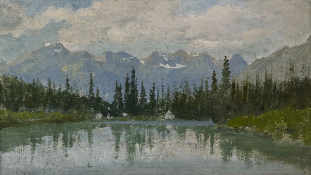
Bow River, Banff
https://archives.whyte.org/en/permalink/artifactbes.02.02
- Date
- prior to 1887
- Medium
- oil on pressed paperboard
- Catalogue Number
- BeS.02.02
- Description
- A view of the Bow River, the river covers most of the bottom half of the picture, 4 white (tents?) structures on bank, middle of picture. A line of evergreens runs through center of picture, mountains (Borgeau Range), some snow,in background, the sky is blue with lots of white clouds.
1 image
- Title
- Bow River, Banff
- Date
- prior to 1887
- Medium
- oil on pressed paperboard
- Dimensions
- 11.9 x 21.7 cm
- Description
- A view of the Bow River, the river covers most of the bottom half of the picture, 4 white (tents?) structures on bank, middle of picture. A line of evergreens runs through center of picture, mountains (Borgeau Range), some snow,in background, the sky is blue with lots of white clouds.
- Credit
- Purchased from Sotheby Parke Bernet (Canada) Ltd, Toronto, 1982
- Catalogue Number
- BeS.02.02
Images
This material is presented as originally created; it may contain outdated cultural descriptions and
potentially offensive content.
Read more.
(Brazeau River area)
https://archives.whyte.org/en/permalink/catalogue24494
- Medium
- Library - Maps and blueprints (unannotated; published)
- Map
- Published Date
- January 4, 1912
- Publisher
- Department of the Interior
- Call Number
- C9-7.41
- Publisher
- Department of the Interior
- Published Date
- January 4, 1912
- Physical Description
- 1 map : black and white
- Scale
- 40 chains: 1 inch
- Accession Number
- SG7500
- Call Number
- C9-7.41
- Collection
- Archives Library
This material is presented as originally created; it may contain outdated cultural descriptions and
potentially offensive content.
Read more.
(Brule Lake-Athabasca River-J.N.P.)
https://archives.whyte.org/en/permalink/catalogue24510
- Medium
- Library - Maps and blueprints (unannotated; published)
- Map
- Published Date
- December 4, 1934
- Publisher
- Department of the Interior
- Call Number
- C9-7.49
- Publisher
- Department of the Interior
- Published Date
- December 4, 1934
- Physical Description
- 1 map : black and white
- Scale
- 40 chains: 1 inch
- Accession Number
- SG7500
- Call Number
- C9-7.49
- Collection
- Archives Library
This material is presented as originally created; it may contain outdated cultural descriptions and
potentially offensive content.
Read more.