Narrow Results By
Banff and Yoho National Parks Photographs
https://archives.whyte.org/en/permalink/descriptions17543
- Part Of
- Bob Hind fonds
- Scope & Content
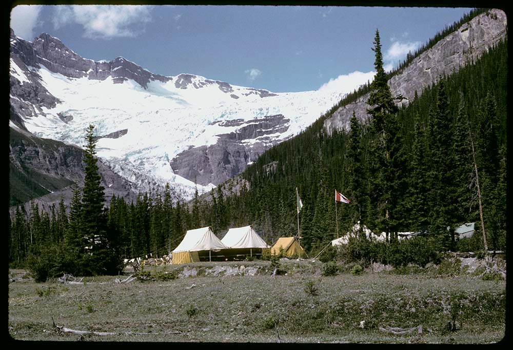
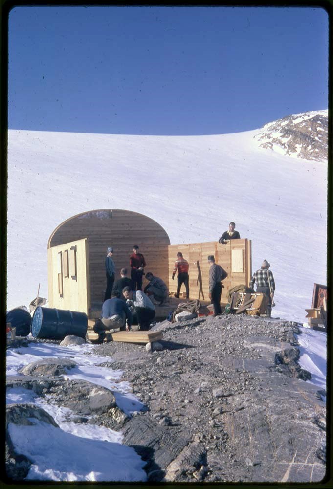
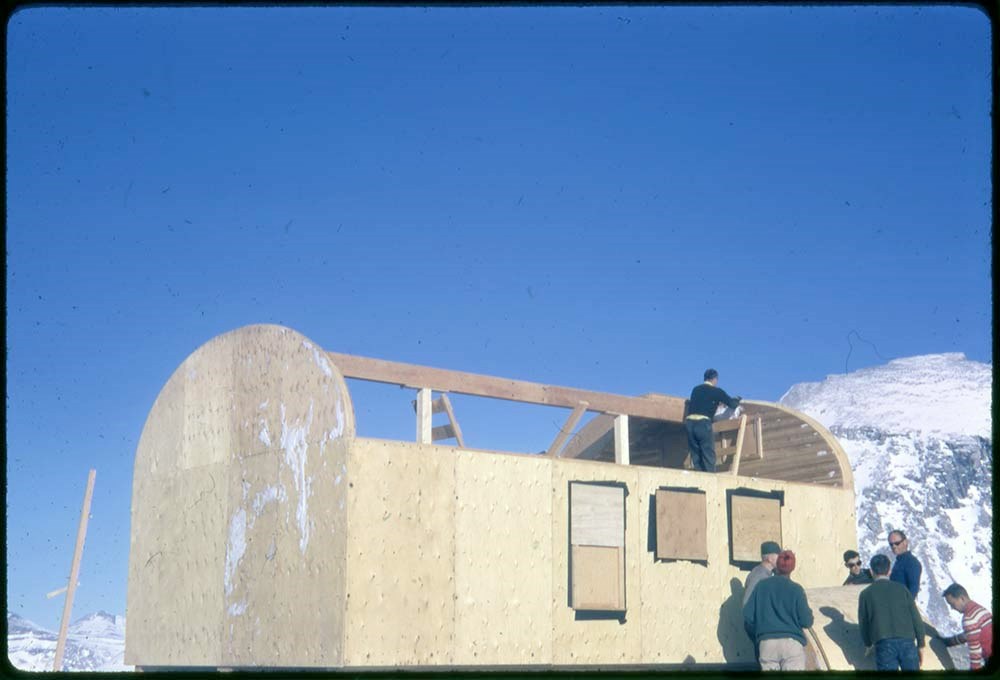
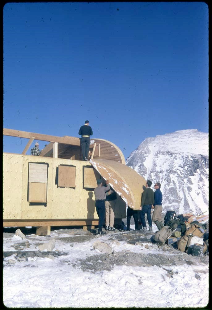
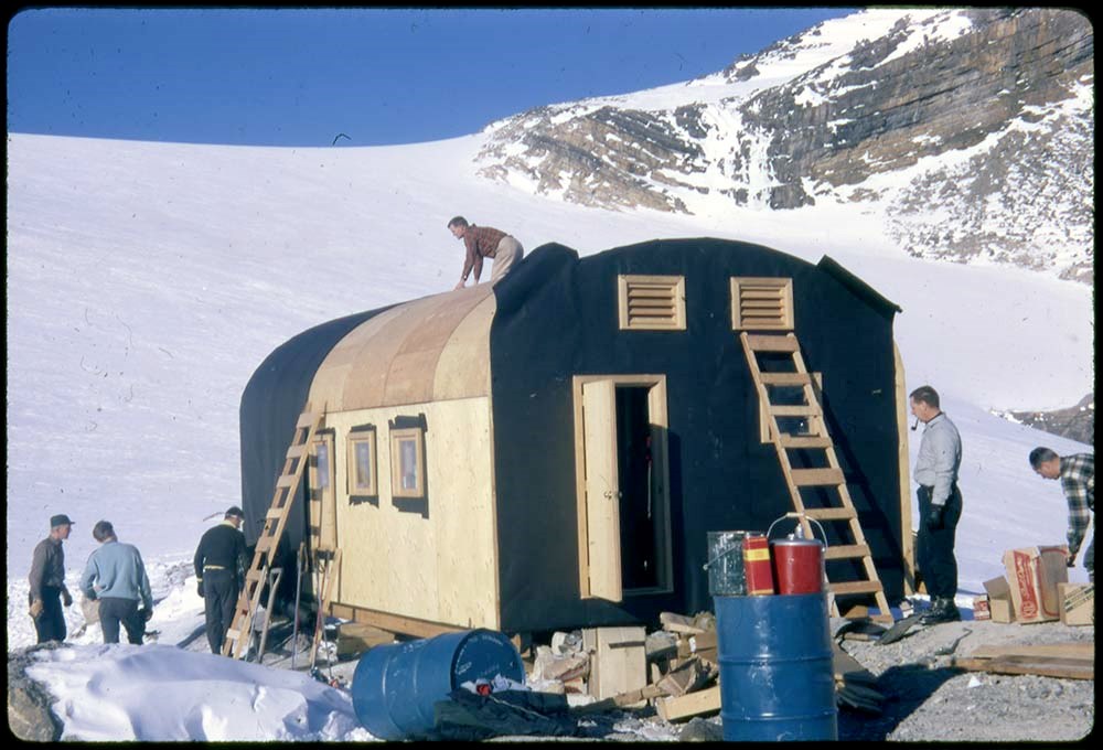
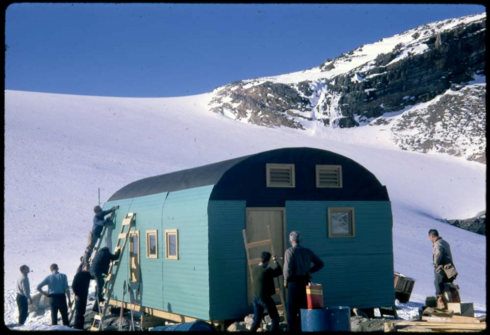
- File pertains to climbing, skiing, ski touring, camps, facilities and landscape views in Banff and Yoho National Parks. Includes the construction of Bow Hut.
- Date Range
- 1944-1990
- Reference Code
- V46 / I / A / 29 / NS - 1 to 493
- Description Level
- 5 / File
- GMD
- Negative
8 images
- Part Of
- Bob Hind fonds
- Description Level
- 5 / File
- Fonds Number
- M7 / V46
- Series
- I.A. Mountain travel and recreation, western Canada : Trips and activities
- Sous-Fonds
- V46
- Accession Number
- 7181
- Reference Code
- V46 / I / A / 29 / NS - 1 to 493
- GMD
- Negative
- Other Title Info
- Alternate title: Banff, Yoho etc from 1950, Gl lake
- Date Range
- 1944-1990
- Physical Description
- 493 photographs : transparencies, 35mm, col
- History / Biographical
- See fonds level description
- Scope & Content
- File pertains to climbing, skiing, ski touring, camps, facilities and landscape views in Banff and Yoho National Parks. Includes the construction of Bow Hut.
- Notes
- LIST OF CONTENTS (V46 / 29 ) :
- * Alta 47, Atha 47 - 1947
- * Landscape/s and hut - 1948
- * M50 : Maligne Lake and camp - 1950
- * SG 51 : glacier, climbing - 1951
- * Mount Hooker area, camps, landscape view/s (S53), climbing - 1953
- * EC55 : Mount Edith Cavell - 1955
- * Moat Lake 57, Athz 57, T57, Eremite 57: landscape view/s, camp, hut - 1957
- * Landscape view/s - 1958
- * Mal62, Maligne 62, Col 62, Colum 62 : landscape view/s, horse trail - 1962
- * Landscape view/s - 1968
- * F76 : flora - 1976
- * Winter landscape view/s and hut - 1978
- Name Access
- Hind, Bob
- Subject Access
- Alpine Club of Canada
- Backcountry skiing
- Buildings and facilities
- Construction
- Exploration
- Glaciers
- Guides
- Guiding
- Geographic Access
- Bow Hut
- Banff National Park
- Yoho National Park
- Alberta
- British Columbia
- Canada
- Language
- NA
- Title Source
- Title based on contents of file
- Content Details
- LIST OF CONTENTS (V46 / 27) :
- * Mountain landscape views - 1947
- * Ski touring, Skoki area; skiing at Mount Norquay - 1948
- * Skiing in Sunshine area - 1949
- * Ski meet : ski meet at Mount Norquay, includes Banff Winter Carnival queen and John Hunter, Stoney First Nation - 1950
- * F50 : Fay Hut, climbing, landscape views. Includes some photographs by MH - 1950
- * KL, KH, Baker, Wapta : Castle Mountain, Wapta cabin and car, landscape views - 1950
- * B51 : Banff Springs Hotel panorama, Cascade of Times garden, bears - 1951
- * S51 : Skoki area, ski touring and landscape views - 1951
- * Cos 51 : wildlife - 1951
- * Y51 : Stanley Mitchell Hut in winter, ski touring group, Yoho area landscape - 1951
- * EIC 51 : landscape views - 1951
- * Hiking in Lake O'Hara area - 1951
- * Sk52 : Skoki area, ski touring and landscape views - 1952
- * Skoki area, Mount Whyte - 1953
- * Banff climbing, landscape views, Lake Louise area, camps, Skoki area, Mount Whyte - 1954
- * Climbing, Skoki Lodge, landscape views - 1955
- * Ski touring, Sunshine area, Mount Temple and Skoki areas, landscape views, Skoki Lodge. Includes label: Class III, Marj Bugler - 1956
- * Mount Cory, climbing and landscape views - 1957
- * Mountain rescue - 1957
- * Banff area, climbing and landscape views - 1958
- * Mount Ishbel, Pilot Mountain, climbing - 1959
- * Ice school, snow school, Banff townsite, Yoho area, climbing Mount Cory, Mount Edith, Mount Ishbel, St. Nic - 1960
- * Skoki : includes Skoki Lodge, ski touring - [1960?]
- * Banff : Vermilion Lakes, Bow Falls, wildlife, Mount Norquay - [1960?]
- * Banff : Banff area, Mount Norquay, chairlift - [ca.1960]
- * Yoho : group at Stanley Mitchell Hut - [ca.1960]
- * Lake Louise - [ca.1960]
- * Emerald : Mount Burgess, Kicking Horse River, ski touring at Sunshine and Mount Temple areas, Mount Norquay ski area, landscape views and people, Peyto Lake, Emerald Lake, Banff-Jasper Highway - [ca.1960]
- * Yoho area, Stanley Mitchell Hut, climber, snowman, climbing Mount Cory, Banff views - 1961
- * Bow Lake - 1962
- * Mount Temple, Banff area - 1963
- * GL recce : Glacier Lake area reconnaissance views, horses and ski touring - 1964
- * Glacier Lake, Alpine Club of Canada camp, botany, glacier climbing - 1965
- * Larch Valley, Moraine Lake, Mount Inglismaldie, Dolomite Peak - 1966
- * Ski touring, Hole-in-the-Wall, landscape, botany - 1967
- * Bow Hut construction, Shadow Lake cabin, children, landscape views - 1968
- * Yoho landscape, Stanley Mitchell Hut, children hiking - 1969
- * Lake O'Hara area - 1969
- * Castleguard Meadows camp, hiking and landscape, Saskatchewan Glacier Hut - 1944-1972
- * Glacier Lake camp (summer), hiking, botany, landscape. Includes competition entries by MGH and RG Hind: Class I, II and IV - 1973
- * Banff area, hiking and landscape, including Heart Mountain, Emerald Lake - 1974
- * Banff Indian Days, Healy Creek - 1975
- * Mountain glacier - 1976
- * Pilot Mountain area (fall/winter) and ski touring; man - 1977
- * Camp (summer), hiking, landscape views - 1978
- * Landscape views, man, woman - 1980
- * Snow crystals, Yoho map - 1981
- * Bow River? view - 1982
- * Cathy wedding; woman at Cascade Mountain - 1983
- * Banff area, Moraine Lake tourist - 1984
- * Man and woman at Castle Mountain - 1987
- * Chateau Lake Louise dinner group - 1990
- Processing Status
- Processed
Images


This material is presented as originally created; it may contain outdated cultural descriptions and
potentially offensive content.
Read more.
Isolated Peak Summit Records
https://archives.whyte.org/en/permalink/descriptions57690
- Part Of
- Alpine Club of Canada fonds
- Scope & Content
- Files consist of summit notes and summit registers and notes from Isolated Peak between 1996 and 2012 produced by the Alpine Club of Canada. Summit records include entries from visitors to the various summits which pertain to individuals' hiking and climbing trips; details of specific events which …
- Date Range
- 1996-2012
- Reference Code
- M200 / V / A / 83 to 84
- Description Level
- 5 / File
- GMD
- Textual record
- Organization record
- Part Of
- Alpine Club of Canada fonds
- Description Level
- 5 / File
- Fonds Number
- M200
- V14
- S6
- Series
- M200 / V: Summit Records
- Sous-Fonds
- M200
- Sub-Series
- M200 / V / A: Identified Summit Records
- Accession Number
- accn. 8002
- accn. 2023.19
- Reference Code
- M200 / V / A / 83 to 84
- Responsibility
- Summit Registers and Notes produced by Alpine Club of Canada
- Date Range
- 1996-2012
- Physical Description
- 2 volumes ca. 2 cm of textual records
- History / Biographical
- Isolated Peak is located in Little Yoho Valley of Yoho National Park, B.C. in the Canadian Rockies. Nearby are Mount McArthur, Arete Peak and Mont des Poilus, Vice President and President Mountains.
- Scope & Content
- Files consist of summit notes and summit registers and notes from Isolated Peak between 1996 and 2012 produced by the Alpine Club of Canada. Summit records include entries from visitors to the various summits which pertain to individuals' hiking and climbing trips; details of specific events which occurred while at the summit, wildlife sightings, trail updates, and related topics. Files include: M200 / V / A / 83: Summit Register - Isolated Peak, July 1996 - Aug 2009 M200 / V / A / 84: Isolated Peak [2009-2012]
- Name Access
- Alpine Club of Canada
- Subject Access
- Alpine Club of Canada
- Backpacking
- Backcountry skiing
- British Columbia
- Climbing
- Club
- Cross-country skiing
- Description and travel
- Environment
- Environment and Nature
- Hiking
- Mountain
- Mountaineering
- Mountaineers
- Mountains
- National parks and reserves
- Parks Canada
- Record keeping
- Ski area
- Ski areas
- Ski mountaineering
- Skiing
- Skiers
- Snowshoes and snowshoeing
- Sports and leisure
- Sports and recreation
- Summit
- Trails
- Winter sports
- Geographic Access
- Canada
- Canadian Rocky Mountains
- Rocky Mountains
- British Columbia
- Yoho National Park
- Little Yoho Valley
- The Vice President
- The President
- Isolated Peak
- Access Restrictions
- Restrictions may apply
- Language
- English
- French
- Conservation
- Summit notes are loose pages and contain water damage. Summit notes may contain rust damage.
- Related Material
- M235
- Biographical Source Notes
- Peak Finder, Isolated Peak, Canadian Rockies Database: https://cdnrockiesdatabases.ca/peaks/687#undefined1
- Title Source
- Title based on contents of file
- Processing Status
- Processed
This material is presented as originally created; it may contain outdated cultural descriptions and
potentially offensive content.
Read more.
Mount Victoria Summit Record
https://archives.whyte.org/en/permalink/descriptions57688
- Part Of
- Alpine Club of Canada fonds
- Scope & Content
- File consists of one summit register from Mount Victoria produced by the Alpine Club of Canada between 1998 and 2004. Summit record include entries from visitors to the various summits which pertain to individuals' hiking and climbing trips; details of specific events which occurred while at the su…
- Date Range
- September 1998 - August 2004
- Reference Code
- M200 / V / A / 81
- Description Level
- 5 / File
- GMD
- Textual record
- Organization record
- Part Of
- Alpine Club of Canada fonds
- Description Level
- 5 / File
- Fonds Number
- M200
- V14
- S6
- Series
- M200 / V: Summit Records
- Sous-Fonds
- M200
- Sub-Series
- M200 / V / A: Identified Summit Records
- Accession Number
- accn. 8002
- Reference Code
- M200 / V / A / 81
- Responsibility
- Summit Registers and Notes produced by Alpine Club of Canada
- Date Range
- September 1998 - August 2004
- Physical Description
- 1 cm of textual records 1 volume
- History / Biographical
- Mount Victoria is located in both Yoho National Park, B. C. and Banff National Park, AB in the Canadian Rockies. The mountain is part of the mountain range along the Continental Divide, between Alberta and B.C. Nearby are Lake O'Hara, Lake Louise, Abbot Pass and Mount Lefroy. Mount Victoria was named for Queen Victoria.
- Scope & Content
- File consists of one summit register from Mount Victoria produced by the Alpine Club of Canada between 1998 and 2004. Summit record include entries from visitors to the various summits which pertain to individuals' hiking and climbing trips; details of specific events which occurred while at the summit, wildlife sightings, trail updates, and related topics. File: M200 / V / A / 81: Summit - MT. Victoria, Sept. 1998 - Aug. 2004
- Name Access
- Alpine Club of Canada
- Subject Access
- Alberta
- Abbot Pass
- Alpine Club of Canada
- Backcountry skiing
- Backpacking
- Banff National Park
- Bow Valley
- British Columbia
- Climbing
- Club
- Cross-country skiing
- Description and travel
- Environment
- Environment and Nature
- Hiking
- Lake Louise
- Lake O'hara
- Mountain
- Mountaineering
- Mountaineers
- Mountains
- Parks Canada
- Record keeping
- Ski area
- Ski areas
- Ski mountaineering
- Ski touring
- Skiers
- Skiing
- Snowshoes and snowshoeing
- Sports and leisure
- Sports and recreation
- Summit
- Trails
- Winter sports
- Geographic Access
- Canada
- Alberta
- British Columbia
- Banff National Park
- Yoho National Park
- Lake O'Hara
- Lake Louise
- Lake Louise, AB
- Abbot Pass
- Abbott Pass
- Mount Lefroy
- Mount Victoria
- Access Restrictions
- Restrictions may apply
- Language
- English
- French
- German
- Japanese
- Related Material
- M235
- Biographical Source Notes
- Peak Finder: Mount Victoria, Canadian Rockies Database: https://cdnrockiesdatabases.ca/peaks/1459
- Title Source
- Title based on contents of file
- Processing Status
- Processed
This material is presented as originally created; it may contain outdated cultural descriptions and
potentially offensive content.
Read more.
Mt. Carnarvon Summit Records
https://archives.whyte.org/en/permalink/descriptions57760
- Part Of
- Alpine Club of Canada fonds
- Scope & Content
- Files consist of summit records from Mount Carnarvon produced by the Alpine Club of Canada between 1990 and 2010. Summit record includes entries from visitors to the various summits which pertain to individuals' hiking and climbing trips; details of specific events which occurred while at the summi…
- Date Range
- 1990-2010
- Reference Code
- M200 / V / A / 203 to 204
- Description Level
- 5 / File
- GMD
- Textual record
- Organization record
- Part Of
- Alpine Club of Canada fonds
- Description Level
- 5 / File
- Fonds Number
- M200
- V14
- S6
- Series
- M200 / V: Summit Records
- Sous-Fonds
- M200
- Sub-Series
- M200 / V / A: Identified Summit Records
- Accession Number
- accn. 2014.8315
- accn. 7779
- Reference Code
- M200 / V / A / 203 to 204
- Responsibility
- Summit Registers and Notes produced by Alpine Club of Canada
- Date Range
- 1990-2010
- Physical Description
- 2 volume 2 cm of textual record
- History / Biographical
- Mount Carnarvon is located in Kiwetinok River Valley of Yoho National Park, British Columbia. It is part of the President Range of the Canadian Rocky Mountains.
- Scope & Content
- Files consist of summit records from Mount Carnarvon produced by the Alpine Club of Canada between 1990 and 2010. Summit record includes entries from visitors to the various summits which pertain to individuals' hiking and climbing trips; details of specific events which occurred while at the summit, wildlife sightings, trail updates, and related topics. File: M200 / V / A / 203: Mt. Carnarvon Jul 14, 1990 - Jul 20, 1997 M200 / V / A / 204: Mt. Carnarvon Log Book [1997-2010]
- Name Access
- Alpine Club of Canada
- Subject Access
- Alpine Club of Canada
- Backpacking
- Backcountry skiing
- British Columbia
- Club
- Climbing
- Description and travel
- Environment
- Environment and Nature
- Hiking
- Mountain
- Mountaineering
- Mountaineers
- Mountains
- National parks and reserves
- Record keeping
- Sports and leisure
- Sports and recreation
- Summit
- Trails
- Geographic Access
- Canada
- Canadian Rocky Mountains
- Rocky Mountains
- President Range
- British Columbia
- Yoho National Park
- Kiwetinok River Valley
- Isolated Peak
- Emerald Lake
- Mount Carnarvon
- Access Restrictions
- Restrictions may apply
- Language
- English
- French
- Spanish
- Related Material
- M235
- Biographical Source Notes
- Peak Finder: Mount Carnarvon, Canadian Rockies Database: https://cdnrockiesdatabases.ca/peaks/216
- Title Source
- Title based on contents of file
- Processing Status
- Processed
This material is presented as originally created; it may contain outdated cultural descriptions and
potentially offensive content.
Read more.
[Mt. Field, 1994-2000]
https://archives.whyte.org/en/permalink/descriptions57708
- Part Of
- Alpine Club of Canada fonds
- Scope & Content
- File consists of a summit record from Mount Field produced by the Alpine Club of Canada between 1994 and 2000. Summit record includes entries from visitors to the various summits which pertain to individuals' hiking and climbing trips; details of specific events which occurred while at the summit, …
- Date Range
- 1994-2000
- Reference Code
- M200 / V / A / 118
- Description Level
- 5 / File
- GMD
- Textual record
- Organization record
- Part Of
- Alpine Club of Canada fonds
- Description Level
- 5 / File
- Fonds Number
- M200
- V14
- S6
- Series
- M200 / V: Summit Records
- Sous-Fonds
- M200
- Sub-Series
- M200 / V / A: Identified Summit Records
- Accession Number
- accn. 2023.10
- Reference Code
- M200 / V / A / 118
- Responsibility
- Summit Registers and Notes produced by Alpine Club of Canada
- Date Range
- 1994-2000
- Physical Description
- 1 volume 0.5 cm of textual record
- History / Biographical
- Mt. Field is located in the Canadian Rockies, in Yoho National Park near the town of Field, B.C. Nearby are Mount Burgess, Wapta Mountain, and Emerald Lake.
- Scope & Content
- File consists of a summit record from Mount Field produced by the Alpine Club of Canada between 1994 and 2000. Summit record includes entries from visitors to the various summits which pertain to individuals' hiking and climbing trips; details of specific events which occurred while at the summit, wildlife sightings, trail updates, and related topics. File: M200 / V / A / 118: [Mt. Field, 1994-2000]
- Name Access
- Alpine Club of Canada
- Subject Access
- Alpine Club of Canada
- Backcountry skiing
- Backpacking
- British Columbia
- Climbing
- Club
- Cross-country skiing
- Description and travel
- Environment
- Environment and Nature
- Hiking
- Mountain
- Mountaineering
- Mountaineers
- Mountains
- National parks and reserves
- Record keeping
- Ski areas
- Ski area
- Ski mountaineering
- Skiers
- Skiing
- Skis
- Sports and leisure
- Sports and recreation
- Summit
- Trails
- Winter sports
- Geographic Access
- Canada
- Canadian Rocky Mountains
- British Columbia
- Yoho National Park
- Field
- Mount Burgess
- Wapta Mountain
- Emerald Lake
- Mount Field, B.C.
- Access Restrictions
- Restrictions may apply
- Language
- English
- Related Material
- M235
- Title Source
- Title based on contents of file
- Processing Status
- Processed
This material is presented as originally created; it may contain outdated cultural descriptions and
potentially offensive content.
Read more.
Mt. Lefroy Summit Records
https://archives.whyte.org/en/permalink/descriptions57737
- Part Of
- Alpine Club of Canada fonds
- Scope & Content
- Files consist of summit notes and summit registers Mount Lefroy produced by the Alpine Club of Canada between 1985 and 2010. Summit records include entries from visitors to the various summits which pertain to individuals' hiking and climbing trips; details of specific events which occurred while a…
- Date Range
- 1985-2010
- Reference Code
- M200 / V / A / 148 to 149
- Description Level
- 5 / File
- GMD
- Textual record
- Organization record
- Part Of
- Alpine Club of Canada fonds
- Description Level
- 5 / File
- Fonds Number
- M200
- V14
- S6
- Series
- M200 / V: Summit Records
- Sous-Fonds
- M200
- Sub-Series
- M200 / V / A: Identified Summit Records
- Accession Number
- accn. 5631
- accn. 2023.19
- Reference Code
- M200 / V / A / 148 to 149
- Responsibility
- Summit Registers and Notes produced by Alpine Club of Canada
- Date Range
- 1985-2010
- Physical Description
- 2 volumes 3 cm of textual records
- History / Biographical
- Mount Lefroy is located in along the Continental/Great Divide, and is part of the Canadian Rocky Mountains. Nearby are Abbot Pass and Mount Victoria. Mount Lefroy is the site of the first fatal mountaineering accident in Canada.
- Scope & Content
- Files consist of summit notes and summit registers Mount Lefroy produced by the Alpine Club of Canada between 1985 and 2010. Summit records include entries from visitors to the various summits which pertain to individuals' hiking and climbing trips; details of specific events which occurred while at the summit, wildlife sightings, trail updates, and related topics. Files include: M200 / V / A / 148: [Mt. Lefroy register 1985-1987] M200 / V / A / 149: Mt. Lefroy. [ca. 1986-2010]
- Name Access
- Alpine Club of Canada
- Subject Access
- Alberta
- Alpine Club of Canada
- Backcountry skiing
- Backpacking
- Banff
- Banff National Park
- British Columbia
- Climbing
- Club
- Description and travel
- Environment
- Environment and Nature
- Great Divide
- Hiking
- Mountain
- Mountaineering
- Mountaineers
- Mountains
- National parks and reserves
- Provincial parks and reserves
- Record keeping
- Ski mountaineering
- Skiing
- Skiers
- Skis
- Sports and leisure
- Sports and recreation
- Summit
- Trails
- Geographic Access
- Canada
- Canadian Rocky Mountains
- Rocky Mountains
- Continental Divide
- Great Divide
- Alberta
- British Columbia
- Banff National Park
- Yoho National Park
- Abbott Pass
- Abbot Pass
- Mount Victoria
- Mount Lefroy
- Access Restrictions
- Restrictions may apply
- Language
- English
- Japanese
- French
- Conservation
- Register has evidence of rust damage and loose pages. Pages have tears and some water damage.
- Related Material
- M235
- Title Source
- Title based on contents of file
- Processing Status
- Processed
This material is presented as originally created; it may contain outdated cultural descriptions and
potentially offensive content.
Read more.
Mt. McPhail Summit Register
https://archives.whyte.org/en/permalink/descriptions57711
- Part Of
- Alpine Club of Canada fonds
- Scope & Content
- File consists of a summit record from Mount McPhail produced by the Alpine Club of Canada around 1994. Summit record includes entries from visitors to the various summits which pertain to individuals' hiking and climbing trips; details of specific events which occurred while at the summit, wildlife…
- Date Range
- ca. 1994
- Reference Code
- M200 / V / A / 121
- Description Level
- 5 / File
- GMD
- Textual record
- Organization record
- Part Of
- Alpine Club of Canada fonds
- Description Level
- 5 / File
- Fonds Number
- M200
- V14
- S6
- Series
- M200 / V: Summit Records
- Sous-Fonds
- M200
- Sub-Series
- M200 / V / A: Identified Summit Records
- Accession Number
- accn. 2014.8293
- Reference Code
- M200 / V / A / 121
- Responsibility
- Summit Registers and Notes produced by Alpine Club of Canada
- Date Range
- ca. 1994
- Physical Description
- 1 volume 1 cm of textual record
- History / Biographical
- Mount McPhail is located in the Elk Range of the Park Ranges of the Canadian Rockies and is along the Continental Divide, between the Alberta and British Columbia border. It is within the Kananaskis Country Provincial Park boundary, Mount McPhail is also known as "The Pyramid" for its shape. The mountain was named for Corporal Norman RR. McPhail, a member of the Surveyor General staff, who fought and was killed in action in WWI.
- Scope & Content
- File consists of a summit record from Mount McPhail produced by the Alpine Club of Canada around 1994. Summit record includes entries from visitors to the various summits which pertain to individuals' hiking and climbing trips; details of specific events which occurred while at the summit, wildlife sightings, trail updates, and related topics. File: M200 / V / A / 121: Mt. McPhail Summit Register
- Name Access
- Alpine Club of Canada
- Subject Access
- Alberta
- Alpine Club of Canada
- Backcountry skiing
- Backpacking
- Banff
- Banff National Park
- Bow Valley
- British Columbia
- Climbing
- Club
- Cross-country skiing
- Description and travel
- Environment
- Environment and Nature
- Hiking
- Kananaskis Country
- Mountain
- Mountaineering
- Mountaineers
- Mountains
- National parks and reserves
- Provincial parks and reserves
- Record keeping
- Ski area
- Ski areas
- Ski mountaineering
- Skiing
- Skiers
- Sports and leisure
- Sports and recreation
- Summit
- Winter sports
- Geographic Access
- Canada
- Canadian Rocky Mountains
- Alberta
- British Columbia
- Banff National Park
- Yoho National Park
- Continental Divide
- Elk Range Mountains
- Mount McPhail
- Access Restrictions
- Restrictions may apply
- Language
- English
- Conservation
- Register contains black mold, water damage. Register is placed in mylar.
- Related Material
- M235
- Biographical Source Notes
- Peak Finder: Mount McPhail, Canadian Rockies Database: https://cdnrockiesdatabases.ca/peaks/889
- Title Source
- Original title used
- Processing Status
- Processed
This material is presented as originally created; it may contain outdated cultural descriptions and
potentially offensive content.
Read more.
Mt. Yukness Summit Records
https://archives.whyte.org/en/permalink/descriptions57687
- Part Of
- Alpine Club of Canada fonds
- Scope & Content
- Files consist of summit notes and summit registers from Mt. Yukness produced by the Alpine Club of Canada between ca. 1962 and 2003. Summit records include entries from visitors to the various summits which pertain to individuals' hiking and climbing trips; details of specific events which occurred…
- Date Range
- ca. 1962-1985
- 1994-2003
- Reference Code
- M200 / V / A / 79 to 80
- Description Level
- 5 / File
- GMD
- Textual record
- Organization record
- Part Of
- Alpine Club of Canada fonds
- Description Level
- 5 / File
- Fonds Number
- M200
- V14
- S6
- Series
- M200 / V: Summit Records
- Sous-Fonds
- M200
- Sub-Series
- M200 / V / A: Identified Summit Records
- Accession Number
- accn. 2023.32
- accn. 8002
- Reference Code
- M200 / V / A / 79 to 80
- Responsibility
- Summit Registers and Notes produced by Alpine Club of Canada
- Date Range
- ca. 1962-1985
- 1994-2003
- Physical Description
- 2 cm of textual records 2 volumes
- History / Biographical
- Mt. Yukness is located near Lake O'Hara in Yoho National Park, B.C. Nearby is Ringrose Peak, Mount Huber, Mount Lefroy, Glacier Peak, and Mount Biddle.
- Scope & Content
- Files consist of summit notes and summit registers from Mt. Yukness produced by the Alpine Club of Canada between ca. 1962 and 2003. Summit records include entries from visitors to the various summits which pertain to individuals' hiking and climbing trips; details of specific events which occurred while at the summit, wildlife sightings, trail updates, and related topics. Files include: M200 / V / A / 79: Mt. Yukness [ca. 1962 - 1985] M200 / V / A / 80: Summit Register - MT. Yukness, 1994 - 2003
- Name Access
- Alpine Club of Canada
- Subject Access
- Alpine Club of Canada
- Backcountry skiing
- Backpacking
- British Columbia
- Climbing
- Cross-country skiing
- Description and travel
- Environment
- Environment and Nature
- Hiking
- Lake O'hara
- Mountain
- Mountaineering
- Mountaineers
- Mountains
- National parks and reserves
- Parks
- Record keeping
- Ski area
- Ski areas
- Ski mountaineering
- Ski touring
- Skiers
- Skiing
- Snowshoes and snowshoeing
- Sports and leisure
- Sports and recreation
- Summit
- Trails
- Winter sports
- Geographic Access
- Canada
- British Columbia
- Canadian Rocky Mountains
- Rocky Mountains
- Yoho National Park
- Lake O'Hara
- Mount Huber
- Mount Lefroy
- Ringrose Peak
- Access Restrictions
- Restrictions may apply
- Language
- English
- Conservation
- M200 / V / A / 80: Summit Register - MT. Yukness, 1994 - 2003 register is placed in mylar due to evidence of mold. This register also contains water damage.
- Related Material
- M235
- Biographical Source Notes
- Mount Yukness, Peak Finder, Canadian Rockies Database: https://cdnrockiesdatabases.ca/peaks/1559
- Title Source
- Title based on contents of file
- Processing Status
- Processed
This material is presented as originally created; it may contain outdated cultural descriptions and
potentially offensive content.
Read more.